|
Submarine Landslide
Submarine landslides are marine landslides that transport sediment across the continental shelf and into the deep ocean. A submarine landslide is initiated when the downwards driving stress (gravity and other factors) exceeds the resisting stress of the seafloor slope material, causing movements along one or more concave to planar rupture surfaces. Submarine landslides take place in a variety of different settings, including planes as low as 1°, and can cause significant damage to both life and property. Recent advances have been made in understanding the nature and processes of submarine landslides through the use of sidescan sonar and other seafloor mapping technology. Causes Submarine landslides have different causes which relate to both the geological attributes of the landslide material and transient environmental factors affecting the submarine environment. Common causes of landslides include: i) presence of weak geological layers, ii) overpressure due to rapid accumulati ... [...More Info...] [...Related Items...] OR: [Wikipedia] [Google] [Baidu] |
Geotechnical
Geotechnical engineering, also known as geotechnics, is the branch of civil engineering concerned with the engineering behavior of earth materials. It uses the principles of soil mechanics and rock mechanics to solve its engineering problems. It also relies on knowledge of geology, hydrology, geophysics, and other related sciences. Geotechnical engineering has applications in military engineering, mining engineering, petroleum engineering, coastal engineering, and offshore construction. The fields of geotechnical engineering and engineering geology have overlapping knowledge areas. However, while geotechnical engineering is a specialty of civil engineering, engineering geology is a specialty of geology. History Humans have historically used soil as a material for flood control, irrigation purposes, burial sites, building foundations, and construction materials for buildings. Dykes, dams, and canals dating back to at least 2000 BCE—found in parts of ancient Egypt, ancient Mes ... [...More Info...] [...Related Items...] OR: [Wikipedia] [Google] [Baidu] |
Groundwater Seepage
Groundwater is the water present beneath Earth's surface in rock and soil pore spaces and in the fractures of rock formations. About 30 percent of all readily available fresh water in the world is groundwater. A unit of rock or an unconsolidated deposit is called an ''aquifer'' when it can yield a usable quantity of water. The depth at which soil pore spaces or fractures and voids in rock become completely saturated with water is called the ''water table''. Groundwater is recharged from the surface; it may discharge from the surface naturally at springs and seeps, and can form oases or wetlands. Groundwater is also often withdrawn for agricultural, municipal, and industrial use by constructing and operating extraction wells. The study of the distribution and movement of groundwater is ''hydrogeology'', also called groundwater hydrology. Typically, groundwater is thought of as water flowing through shallow aquifers, but, in the technical sense, it can also contain soil moistu ... [...More Info...] [...Related Items...] OR: [Wikipedia] [Google] [Baidu] |
Natural Gas
Natural gas (also fossil gas, methane gas, and gas) is a naturally occurring compound of gaseous hydrocarbons, primarily methane (95%), small amounts of higher alkanes, and traces of carbon dioxide and nitrogen, hydrogen sulfide and helium. Methane is a colorless and odorless gas, and, after carbon dioxide, is the second-greatest greenhouse gas that contributes to global climate change. Because natural gas is odorless, a commercial odorizer, such as Methanethiol (mercaptan brand), that smells of hydrogen sulfide (rotten eggs) is added to the gas for the ready detection of gas leaks. Natural gas is a fossil fuel that is formed when layers of organic matter (primarily marine microorganisms) are thermally decomposed under oxygen-free conditions, subjected to intense heat and pressure underground over millions of years. The energy that the decayed organisms originally obtained from the sun via photosynthesis is stored as chemical energy within the molecules of methane and other ... [...More Info...] [...Related Items...] OR: [Wikipedia] [Google] [Baidu] |
Hurricane Camille
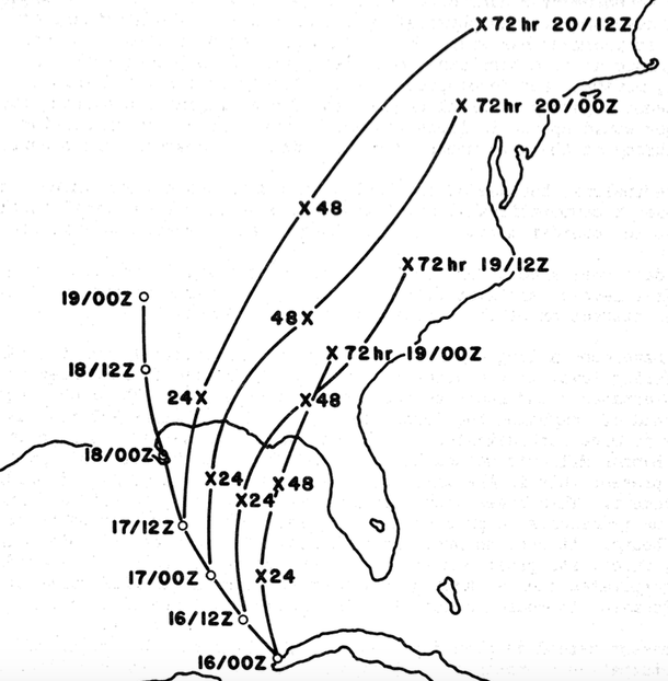
Hurricane Camille was a powerful, deadly and destructive tropical cyclone which became the second most intense on record to strike the United States (behind the 1935 Labor Day hurricane) and is one of the four Category 5 hurricanes to make landfall in the United States. The most intense storm of the 1969 Atlantic hurricane season, Camille originated as a tropical depression on August 14, south of Cuba, from a long-tracked tropical wave. Located in a favorable environment for strengthening, the storm quickly intensified into a Category 2 hurricane before striking the western part of Cuba on August 15. Emerging into the Gulf of Mexico, Camille underwent another period of rapid intensification and became a Category 5 hurricane the next day as it moved northward towards Louisiana and Mississippi. Despite weakening slightly on August 17, the hurricane quickly re-intensified back into a Category 5 hurricane before it made landfall a half hour before midnight in Bay St. Louis, ... [...More Info...] [...Related Items...] OR: [Wikipedia] [Google] [Baidu] |
Mississippi Delta
The Mississippi Delta, also known as the Yazoo–Mississippi Delta, or simply the Delta, is the distinctive northwest section of the U.S. state of Mississippi (and portions of Arkansas and Louisiana) that lies between the Mississippi and Yazoo rivers. The region has been called "The Most Southern Place on Earth" ("Southern" in the sense of "characteristic of its region, the American South"), because of its unique racial, cultural, and economic history. The Delta is long and across at its widest point, encompassing about , or, almost 7,000 square miles of alluvial floodplain. Originally covered in hardwood forest across the bottomlands, it was developed as one of the richest cotton-growing areas in the nation before the American Civil War (1861–1865). The region attracted many speculators who developed land along the riverfronts for cotton plantations; they became wealthy planters dependent on the labor of people they enslaved, who composed the vast majority of the popula ... [...More Info...] [...Related Items...] OR: [Wikipedia] [Google] [Baidu] |
Hurricane
A tropical cyclone is a rapidly rotating storm system with a low-pressure area, a closed low-level atmospheric circulation, strong winds, and a spiral arrangement of thunderstorms that produce heavy rain and squalls. Depending on its location and strength, a tropical cyclone is called a hurricane (), typhoon (), tropical storm, cyclonic storm, tropical depression, or simply cyclone. A hurricane is a strong tropical cyclone that occurs in the Atlantic Ocean or northeastern Pacific Ocean. A typhoon is the same thing which occurs in the northwestern Pacific Ocean. In the Indian Ocean and South Pacific, comparable storms are referred to as "tropical cyclones". In modern times, on average around 80 to 90 named tropical cyclones form each year around the world, over half of which develop hurricane-force winds of or more. Tropical cyclones typically form over large bodies of relatively warm water. They derive their energy through the evaporation of water from the ocean ... [...More Info...] [...Related Items...] OR: [Wikipedia] [Google] [Baidu] |
Grand Banks
The Grand Banks of Newfoundland are a series of underwater plateaus south-east of the island of Newfoundland on the North American continental shelf. The Grand Banks are one of the world's richest fishing grounds, supporting Atlantic cod, swordfish, haddock and capelin, as well as shellfish, seabirds and sea mammals. Significance The Grand Banks of Newfoundland are a group of underwater plateaus south-east of Newfoundland on the North American continental shelf. These areas are relatively shallow, ranging from in depth. The cold Labrador Current mixes with the warm waters of the Gulf Stream here, often causing extreme foggy conditions. The mixing of these waters and the shape of the ocean bottom lifts nutrients to the surface. These conditions helped to create one of the richest fishing grounds in the world. Fish species include Atlantic cod, swordfish, haddock and capelin; shellfish include scallop and lobster. The area also supports large colonies of seabirds such a ... [...More Info...] [...Related Items...] OR: [Wikipedia] [Google] [Baidu] |
Earthquake
An earthquakealso called a quake, tremor, or tembloris the shaking of the Earth's surface resulting from a sudden release of energy in the lithosphere that creates seismic waves. Earthquakes can range in intensity, from those so weak they cannot be felt, to those violent enough to propel objects and people into the air, damage critical infrastructure, and wreak destruction across entire cities. The seismic activity of an area is the frequency, type, and size of earthquakes experienced over a particular time. The seismicity at a particular location in the Earth is the average rate of seismic energy release per unit volume. In its most general sense, the word ''earthquake'' is used to describe any seismic event that generates seismic waves. Earthquakes can occur naturally or be induced by human activities, such as mining, fracking, and nuclear weapons testing. The initial point of rupture is called the hypocenter or focus, while the ground level directly above it is the ... [...More Info...] [...Related Items...] OR: [Wikipedia] [Google] [Baidu] |
Hurricane Camile
Hurricane Camille was a powerful, deadly and destructive tropical cyclone which became the second most intense on record to strike the United States (behind the 1935 Labor Day hurricane) and is one of the four Category 5 hurricanes to make landfall in the United States. The most intense storm of the 1969 Atlantic hurricane season, Camille originated as a tropical depression on August 14, south of Cuba, from a long-tracked tropical wave. Located in a favorable environment for strengthening, the storm quickly intensified into a Category 2 hurricane before striking the western part of Cuba on August 15. Emerging into the Gulf of Mexico, Camille underwent another period of rapid intensification and became a Category 5 hurricane the next day as it moved northward towards Louisiana and Mississippi. Despite weakening slightly on August 17, the hurricane quickly re-intensified back into a Category 5 hurricane before it made landfall a half hour before midnight in Bay St. Louis ... [...More Info...] [...Related Items...] OR: [Wikipedia] [Google] [Baidu] |
Mississippi River Delta
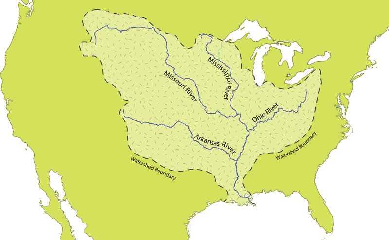
The Mississippi River Delta is the confluence of the Mississippi River with the Gulf of Mexico in Louisiana, southeastern United States. The river delta is a area of land that stretches from Vermilion Bay on the west, to the Chandeleur Islands in the east, on Louisiana's southeastern coast. Scale 1:265,000, 12 p. pamphlet. It is part of the Gulf of Mexico and the Louisiana coastal plain, one of the largest areas of coastal wetlands in the United States.Louisiana's Coastal Area. "Ecosystem Restoration." LCA – Louisiana Coastal Area. The Mississippi River Delta is the seventh-largest river delta on Earth (USGS) and is an important coastal region for the United States, containing more than of coastal wetlands and 37% of the estuarine marsh in the conterminous U.S. The coastal area is the nation's largest drainage basin and drains about 41% of the contiguous United States into the Gulf of Mexico at an average rate of . History and growth The modern Mississippi River D ... [...More Info...] [...Related Items...] OR: [Wikipedia] [Google] [Baidu] |
Sediment
Sediment is a solid material that is transported to a new location where it is deposited. It occurs naturally and, through the processes of weathering and erosion, is broken down and subsequently sediment transport, transported by the action of wind, water, or ice or by the force of gravity acting on the particles. For example, sand and silt can be carried in suspension (chemistry), suspension in river water and on reaching the sea bed deposited by sedimentation; if buried, they may eventually become sandstone and siltstone (sedimentary rocks) through lithification. Sediments are most often transported by water (fluvial, fluvial processes), but also wind (aeolian processes) and glaciers. Beach sands and stream channel, river channel deposits are examples of fluvial transport and deposition (geology), deposition, though sediment also often settles out of slow-moving or standing water in lakes and oceans. Desert sand dunes and loess are examples of aeolian transport and deposition. ... [...More Info...] [...Related Items...] OR: [Wikipedia] [Google] [Baidu] |


