|
St. Mary's Bay (Newfoundland And Labrador)
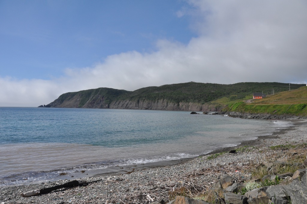
St. Mary's Bay is one of many bays in Newfoundland and Labrador, Newfoundland, Canada, where bay is taken as a regional subdivision, somewhat along the lines of county divisions (Newfoundland, a largely maritime society, lacks counties). It is the most southern and eastern of Newfoundland's major bays. It is located on the southern shore of the Avalon Peninsula and is the heartland of the Irish Newfoundlanders, who live all along its shores, stretching west to the Cape Shore and Placentia, Newfoundland and Labrador, Placentia and northeast to the Southern Shore and St. John's, Newfoundland and Labrador, St. John's. Like most Irish Newfoundlanders, area residents trace their ancestry to County Waterford, County Wexford, County Kilkenny, south County Tipperary and east County Cork. In addition to being Irish, the region is also overwhelmingly Roman Catholic. St. Mary's Bay is an exceedingly rural area. None of the communities in the bay have a population in excess of 1000, and the ... [...More Info...] [...Related Items...] OR: [Wikipedia] [Google] [Baidu] |
Newfoundland And Labrador
Newfoundland and Labrador is the easternmost province of Canada, in the country's Atlantic region. The province comprises the island of Newfoundland and the continental region of Labrador, having a total size of . As of 2025 the population of Newfoundland and Labrador was estimated to be 545,579. The island of Newfoundland (and its smaller neighbouring islands) is home to around 94 per cent of the province's population, with more than half residing in the Avalon Peninsula. Labrador has a land border with both the province of Quebec, as well as a short border with the territory of Nunavut on Killiniq Island. The French overseas collectivity of Saint Pierre and Miquelon lies about west of the Burin Peninsula. According to the 2016 census, 97.0% of residents reported English as their native language, making Newfoundland and Labrador Canada's most linguistically homogeneous province. Much of the population is descended from English and Irish settlers, with the majority ... [...More Info...] [...Related Items...] OR: [Wikipedia] [Google] [Baidu] |
Placentia Bay
Placentia Bay () is a body of water on the southeast coast of Newfoundland, Canada. It is formed by Burin Peninsula on the west and Avalon Peninsula on the east. Fishing grounds in the bay were used by native people long before the first European fishermen arrived in the 16th century. For a time, the French controlled the bay. They built their capital at Placentia on the east coast. The British gained Placentia during the Treaty of Utrecht in 1713. The town and nearby Castle Hill are national historic sites. English settlement followed in the bay and today the main communities are Burin, Marystown, and Placentia. On 14 August 1941 US Naval Station Argentia located in Little Placentia Sound was the site of the Atlantic Conference for the Atlantic Charter, where Winston Churchill and Franklin D. Roosevelt met face to face for the first time since both took office and the start of World War II World War II or the Second World War (1 September 1939 – 2 Septem ... [...More Info...] [...Related Items...] OR: [Wikipedia] [Google] [Baidu] |
New Bridge, Newfoundland And Labrador
New Bridge is a settlement in Newfoundland and Labrador Newfoundland and Labrador is the easternmost province of Canada, in the country's Atlantic region. The province comprises the island of Newfoundland and the continental region of Labrador, having a total size of . As of 2025 the populatio .... Populated places in Newfoundland and Labrador {{Newfoundland-geo-stub ... [...More Info...] [...Related Items...] OR: [Wikipedia] [Google] [Baidu] |
Mitchells Brook, Newfoundland And Labrador
Mount Carmel-Mitchells Brook-St. Catherines is a town in the Canadian province of Newfoundland and Labrador. The town had a population of 382 in the Canada 2021 Census. Demographics In the 2021 Census of Population conducted by Statistics Canada, Mount Carmel-Mitchells Brook-St. Catherine's had a population of living in of its total private dwellings, a change of from its 2016 population of . With a land area of , it had a population density of in 2021. See also * List of cities and towns in Newfoundland and Labrador Newfoundland and Labrador is the ninth-most populous province in Canada, with 510,550 residents recorded in the 2021 Canadian Census, and is the seventh-largest in land area, with . Newfoundland and Labrador has 278 municipalities, including 3 ... References Towns in Newfoundland and Labrador {{Newfoundland-geo-stub ... [...More Info...] [...Related Items...] OR: [Wikipedia] [Google] [Baidu] |
Mount Carmel, Newfoundland And Labrador
Mount is often used as part of the name of specific mountains, e.g. Mount Everest. Mount or Mounts may also refer to: Places * Mount, Cornwall, a village in Warleggan parish, England * Mount, Perranzabuloe, a hamlet in Perranzabuloe parish, Cornwall, England People * Mount (surname) * William L. Mounts (1862–1929), American lawyer and politician Computing and software * Mount (computing), the process of making a file system accessible * Mount (Unix), the utility in Unix-like operating systems which mounts file systems Books * ''Mount!'', a 2016 novel by Jilly Cooper Displays and equipment * Mount, a fixed point for attaching equipment, such as a hardpoint on an airframe * Mounting board, in picture framing * Mount, a hanging scroll for mounting paintings * Mount, to display an item on a heavy backing such as foamcore, e.g.: ** To pin a biological specimen, on a heavy backing in a stretched stable position for ease of dissection or display ** To prepare dead animal ... [...More Info...] [...Related Items...] OR: [Wikipedia] [Google] [Baidu] |
Division 1, Newfoundland And Labrador
Division 1, Newfoundland and Labrador is a census division covering the entire Avalon Peninsula including the Isthmus of Avalon of the Canadian province of Newfoundland and Labrador. Like all census divisions in Newfoundland and Labrador, but unlike the census divisions of some other provinces, the division exists only as a statistical division for census data, and is not a political entity. The area has the largest population of the province, totaling 270,348 – 52% of the provincial total – in 2016. The total land area is 9,220.61 square kilometres. The coast of the Avalon Peninsula is characterized by four main bays and a number of smaller bays. The four main bays are; Trinity Bay, Conception Bay, St. Mary's Bay and Placentia Bay. The largest bay is Placentia Bay. St. John's, the capital of the province, is located in this division along with the second largest of the three cities of the province, Mount Pearl. The majority of the towns and villages are located along the coa ... [...More Info...] [...Related Items...] OR: [Wikipedia] [Google] [Baidu] |
North Harbour, Newfoundland And Labrador
North Harbour is a designated place in the Canadian province of Newfoundland and Labrador on St. Mary's Bay of the island of Newfoundland. Geography North Harbour is in Newfoundland within Subdivision X of Division No. 1. Demographics As a designated place in the 2016 Census of Population conducted by Statistics Canada, North Harbour recorded a population of 69 living in 32 of its 61 total private dwellings, a change of from its 2011 population of 92. With a land area of , it had a population density of in 2016. See also *List of communities in Newfoundland and Labrador *List of designated places in Newfoundland and Labrador A designated place is a type of geographic unit used by Statistics Canada to disseminate census data. It is usually "a small community that does not meet the criteria used to define incorporated municipalities or Statistics Canada Population cen ... References {{Subdivisions of Newfoundland and Labrador, state=collapsed, LSD/DPL=yes ... [...More Info...] [...Related Items...] OR: [Wikipedia] [Google] [Baidu] |
Branch, Newfoundland And Labrador
The Town of Branch is an incorporated community of Newfoundland and Labrador, Canada and had a population of 223 (as of the 2021 census). Geography It is located on St. Mary's Bay and can be accessed via Route 100 or Route 92. Nearby communities include Point Lance and St. Bride's, Newfoundland and Labrador. History The first settler of Branch was Thomas Nash, an Irish fisherman and boat builder. He arrived in Caplin Bay (Calvert) on the Southern Shore in 1765 and eventually came to Branch in the year 1790. Demographics In the 2021 Census of Population conducted by Statistics Canada Statistics Canada (StatCan; ), formed in 1971, is the agency of the Government of Canada commissioned with producing statistics to help better understand Canada, its population, resources, economy, society, and culture. It is headquartered in ..., Branch had a population of living in of its total private dwellings, a change of from its 2016 population of . With a land area of ... [...More Info...] [...Related Items...] OR: [Wikipedia] [Google] [Baidu] |
Point Lance, Newfoundland And Labrador
Point Lance is a town in the Canadian province of Newfoundland and Labrador. In 2016, Point Lance Road was voted Worst Road in Atlantic Canada by the Canadian Automobile Association's Worst Roads list. Demographics In the 2021 Census of Population conducted by Statistics Canada, Point Lance had a population of living in of its total private dwellings, a change of from its 2016 population of . With a land area of , it had a population density of in 2021. Notable people * Nick Careen, politician See also * List of cities and towns in Newfoundland and Labrador Newfoundland and Labrador is the ninth-most populous province in Canada, with 510,550 residents recorded in the 2021 Canadian Census, and is the seventh-largest in land area, with . Newfoundland and Labrador has 278 municipalities, including 3 ... References Towns in Newfoundland and Labrador {{Newfoundland-geo-stub ... [...More Info...] [...Related Items...] OR: [Wikipedia] [Google] [Baidu] |
Clockwise
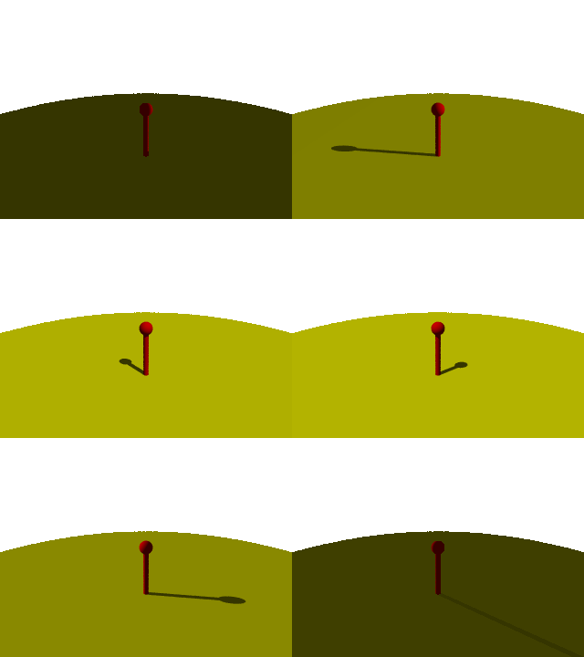
Two-dimensional rotation can occur in two possible directions or senses of rotation. Clockwise motion (abbreviated CW) proceeds in the same direction as a clock's hands relative to the observer: from the top to the right, then down and then to the left, and back up to the top. The opposite sense of rotation or revolution is (in Commonwealth English) anticlockwise (ACW) or (in North American English) counterclockwise (CCW). Three-dimensional rotation can have similarly defined senses when considering the corresponding angular velocity vector. Terminology Before clocks were commonplace, the terms " sunwise" and "deasil", "deiseil" and even "deocil" from the Scottish Gaelic language and from the same root as the Latin "dexter" ("right") were used for clockwise. " Widdershins" or "withershins" (from Middle Low German "weddersinnes", "opposite course") was used for counterclockwise. The terms clockwise and counterclockwise can only be applied to a rotational motion once a side ... [...More Info...] [...Related Items...] OR: [Wikipedia] [Google] [Baidu] |


