|
Spatial Reconnaissance
:''This article incorporates text from thUnited States Governmentaccess site.'' Spatial reconnaissance, or "space reconnaissance", is the reconnaissance of any celestial bodies in space by use of spacecraft and satellite photography. NASA personnel utilize space reconnaissance to scout other planets, military uses space reconnaissance by using spy satellites onto the Earth's surface. Space reconnaissance assets provide access to all parts of the globe and use a variety of sensors to collect information responsive to virtually every intelligence need. They also constitute an integral part of the U.S. military force structure, providing critical information with sufficient accuracy and timeliness to support the maneuver of military forces and the targeting of their weapons. Space reconnaissance is also very expensive. Although procured in limited numbers, the large satellite systems developed by the United States and the ground stations needed to operate them require expenditure ... [...More Info...] [...Related Items...] OR: [Wikipedia] [Google] [Baidu] |
Reconnaissance
In military operations, reconnaissance or scouting is the exploration of an area by military forces to obtain information about enemy forces, terrain, and other activities. Examples of reconnaissance include patrolling by troops ( skirmishers, long-range reconnaissance patrol, U.S. Army Rangers, cavalry scouts, or military intelligence specialists), ships or submarines, crewed or uncrewed reconnaissance aircraft, satellites, or by setting up observation posts. Espionage is usually considered to be different from reconnaissance, as it is performed by non-uniformed personnel operating behind enemy lines. Often called recce (British, Canadian and Australian English) or recon (American English), the word for this activity has at its root the associated verb ''reconnoitre'' or ''reconnoiter''. Etymology The word from the Middle French ''reconoissance''. Overview Reconnaissance conducted by ground forces includes special reconnaissance, armored reconnaissance, amph ... [...More Info...] [...Related Items...] OR: [Wikipedia] [Google] [Baidu] |
Satellite Photography
Satellite images (also Earth observation imagery, spaceborne photography, or simply satellite photo) are images of Earth collected by imaging satellites operated by governments and businesses around the world. Satellite imaging companies sell images by licensing them to governments and businesses such as Apple Maps and Google Maps. History The first images from space were taken on sub-orbital flights. The U.S-launched V-2 flight on October 24, 1946, took one image every 1.5 seconds. With an apogee of 65 miles (105 km), these photos were from five times higher than the previous record, the 13.7 miles (22 km) by the Explorer II balloon mission in 1935. The first satellite (orbital) photographs of Earth were made on August 14, 1959, by the U.S. Explorer 6. The first satellite photographs of the Moon might have been made on October 6, 1959, by the Soviet satellite Luna 3, on a mission to photograph the far side of the Moon. The Blue Marble photograph was taken from spa ... [...More Info...] [...Related Items...] OR: [Wikipedia] [Google] [Baidu] |
Reconnaissance Satellite
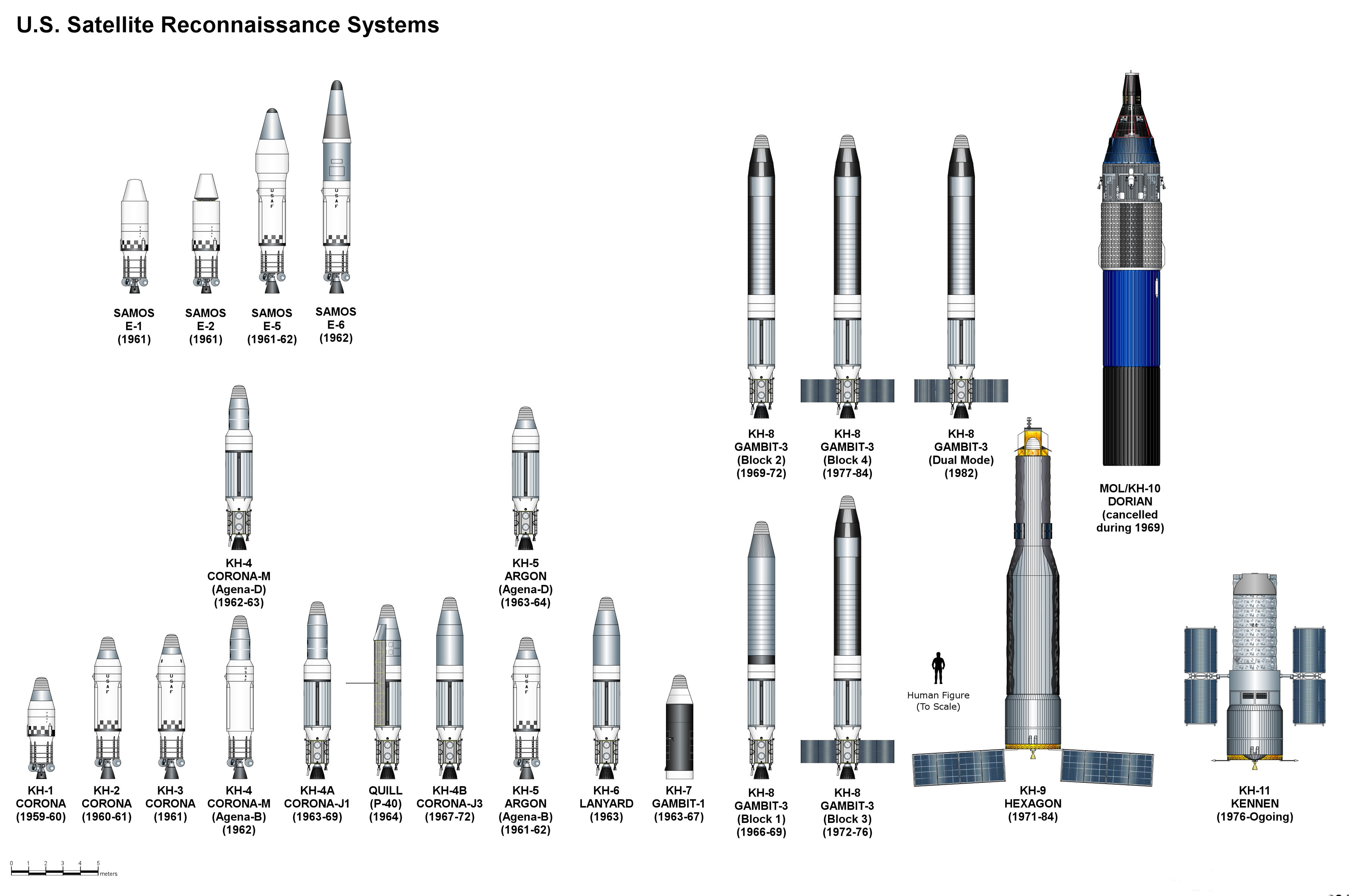
A reconnaissance satellite or intelligence satellite (commonly, although unofficially, referred to as a spy satellite) is an Earth observation satellite or communications satellite deployed for military or intelligence applications. The first generation type (i.e., Corona and Zenit) took photographs, then ejected canisters of photographic film which would descend back down into Earth's atmosphere. Corona capsules were retrieved in mid-air as they floated down on parachutes. Later, spacecraft had digital imaging systems and downloaded the images via encrypted radio links. In the United States, most information available about reconnaissance satellites is on programs that existed up to 1972, as this information has been declassified due to its age. Some information about programs before that time is still classified information, and a small amount of information is available on subsequent missions. A few up-to-date reconnaissance satellite images have been declassif ... [...More Info...] [...Related Items...] OR: [Wikipedia] [Google] [Baidu] |
Aerial Surveillance
A surveillance aircraft is an aircraft used for surveillance. They are operated by military forces and other government agencies in roles such as intelligence gathering, battlefield surveillance, airspace surveillance, reconnaissance, observation (e.g. artillery spotting), border patrol and fishery protection. This article concentrates on aircraft used in those roles, rather than for traffic monitoring, law enforcement and similar activities. Surveillance aircraft usually carry no armament, or only limited defensive armament. They do not always require high-performance capability or stealth characteristics, and may be modified civilian aircraft. Surveillance aircraft have also included moored balloons (e.g. TARS) and unmanned aerial vehicles (UAVs). Definitions The terms “surveillance” and “reconnaissance” have sometimes been used interchangeably, but, in the military context, a distinction can be drawn between surveillance, which monitors a changing situation ... [...More Info...] [...Related Items...] OR: [Wikipedia] [Google] [Baidu] |
National Reconnaissance Office
The National Reconnaissance Office (NRO) is a member of the United States Intelligence Community and an agency of the United States Department of Defense which designs, builds, launches, and operates the reconnaissance satellites of the U.S. federal government, and provides satellite intelligence to several government agencies, particularly signals intelligence (SIGINT) to the NSA, imagery intelligence (IMINT) to the NGA, and measurement and signature intelligence (MASINT) to the DIA. NRO is considered, along with the Central Intelligence Agency (CIA), National Security Agency (NSA), Defense Intelligence Agency (DIA), and National Geospatial-Intelligence Agency (NGA), to be one of the "big five" U.S. intelligence agencies. The NRO is headquartered in Chantilly, Virginia, south of the Washington Dulles International Airport. The Director of the NRO reports to both the Director of National Intelligence and the Secretary of Defense. The NRO's federal workforce is a hybr ... [...More Info...] [...Related Items...] OR: [Wikipedia] [Google] [Baidu] |
Reconnaissance Satellites
A reconnaissance satellite or intelligence satellite (commonly, although unofficially, referred to as a spy satellite) is an Earth observation satellite or communications satellite deployed for military or intelligence applications. The first generation type (i.e., Corona and Zenit) took photographs, then ejected canisters of photographic film which would descend back down into Earth's atmosphere. Corona capsules were retrieved in mid-air as they floated down on parachutes. Later, spacecraft had digital imaging systems and downloaded the images via encrypted radio links. In the United States, most information available about reconnaissance satellites is on programs that existed up to 1972, as this information has been declassified due to its age. Some information about programs before that time is still classified information, and a small amount of information is available on subsequent missions. A few up-to-date reconnaissance satellite images have been declassif ... [...More Info...] [...Related Items...] OR: [Wikipedia] [Google] [Baidu] |
Spaceflight Concepts
Spaceflight (or space flight) is an application of astronautics to fly spacecraft into or through outer space, either with or without humans on board. Most spaceflight is uncrewed and conducted mainly with spacecraft such as satellites in orbit around Earth, but also includes space probes for flights beyond Earth orbit. Such spaceflight operates either by telerobotic or autonomous control. The more complex human spaceflight has been pursued soon after the first orbital satellites and has reached the Moon and permanent human presence in space around Earth, particularly with the use of space stations. Human spaceflight programs include the Soyuz, Shenzhou, the past Apollo Moon landing and the Space Shuttle programs, with currently the International Space Station as the main destination of human spaceflight missions while China's Tiangong Space Station is under construction. Spaceflight is used for placing in Earth's orbit communications satellites, reconnaissance satell ... [...More Info...] [...Related Items...] OR: [Wikipedia] [Google] [Baidu] |


