|
Pian D'Alma
Pian d'Alma is a village in Tuscany, central Italy, administratively a frazione of the comuni of Castiglione della Pescaia and Scarlino, province of Grosseto. At the time of the 2001 census its population amounted to 24. Istat Pian d'Alma is about 38 km from , 17 km from |
Province Of Grosseto
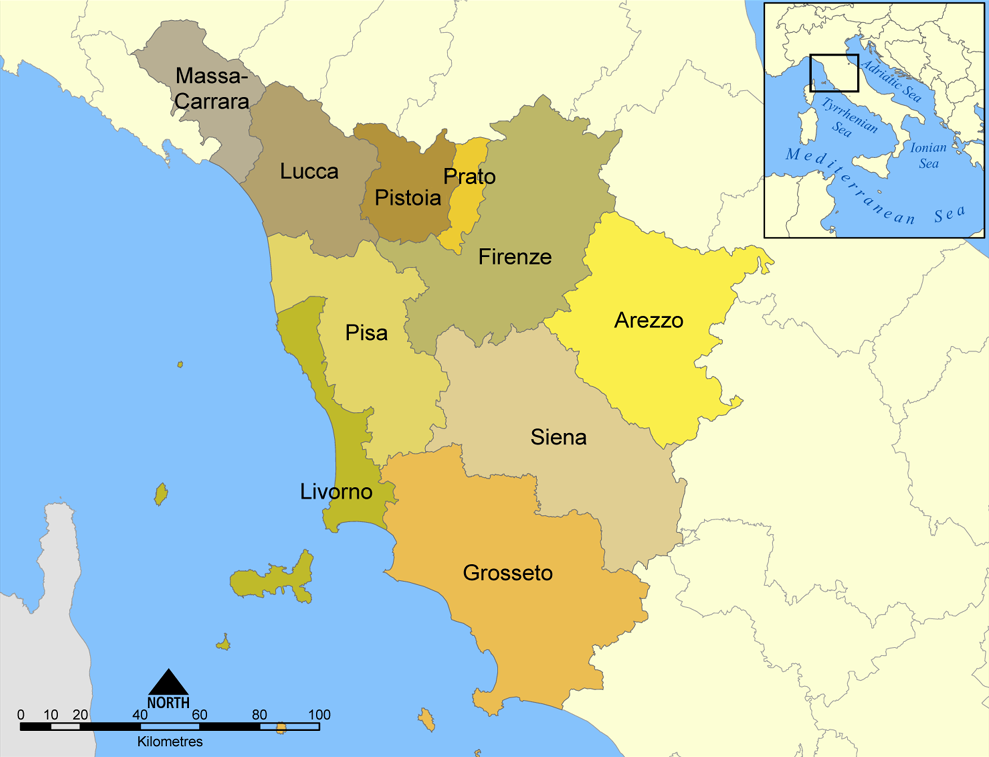
The province of Grosseto () is a Provinces of Italy, province in the Tuscany region of Italy. Its capital is the city of Grosseto. As of 2013 the province had a total population of 225,098 people. Geography The Province of Grosseto completely occupies the southern end of Tuscany, and with a territorial area of , it is the most extensive in the region and one of the least dense in population in Italy. The province is bordered to the northwest by the Province of Livorno, to the north by the Province of Pisa, to the northeast by the Province of Siena, and to the southeast by the Province of Viterbo in Lazio. To the south is the Tyrrhenian Sea, which includes the southern islands of the Tuscan archipelago, including Isola del Giglio and the smaller Giannutri islands and Formiche di Grosseto and Formica di Burano. The Arcipelago Toscano National Park spans both the provinces of Grosseto and Livorno, and includes the seven main islands of the Tuscan Archipelago: Elba, Isola del Gigl ... [...More Info...] [...Related Items...] OR: [Wikipedia] [Google] [Baidu] |
Tyrrhenian Sea
The Tyrrhenian Sea (, ; or ) , , , , is part of the Mediterranean Sea off the western coast of Italy. It is named for the Tyrrhenians, Tyrrhenian people identified with the Etruscans of Italy. Geography The sea is bounded by the islands of Corsica and Sardinia (to the west), the Italian Peninsula (regions of Tuscany, Lazio, Campania, Basilicata, and Calabria) to the north and east, and the island of Sicily (to the south). The Tyrrhenian Sea also includes a number of smaller islands like Capri, Elba, Ischia, and Ustica. The maximum depth of the sea is . The Tyrrhenian Sea is situated near where the African Plate, African and Eurasian Plates meet; therefore mountain chains and active volcanoes, such as Mount Marsili, are found in its depths. The eight Aeolian Islands and Ustica are located in the southern part of the sea, north of Sicily. Extent The International Hydrographic Organization defines the limits of the Tyrrhenian Sea as follows: * In the Strait of Messina: A line ... [...More Info...] [...Related Items...] OR: [Wikipedia] [Google] [Baidu] |
Vetulonia
Vetulonia, formerly called Vetulonium ( Etruscan: ''Vatluna''), was an ancient town of Etruria, Italy, the site of which is probably occupied by the modern village of Vetulonia, which up to 1887 bore the name of Colonnata and Colonna di Buriano: the site is currently a ''frazione'' of the comune of Castiglione della Pescaia (province of Grosseto) with some 400 inhabitants. It lies 300m above sea level, about ten miles directly northwest of Grosseto, on the northeast side of the hills which project from the flat Maremma and form the promontory of Castiglione. History and main sights Vetulonia has Etruscan origins. It was, by 600 BC, part of the Etruscan League of twelve cities. Dionysius of Halicarnassus places the city within the Latin alliance against Rome in the seventh century BC. According to Silius Italicus (''Punica'' VIII.485ff), the Romans adopted their magisterial insignia, the Lictors' rods and fasces and the curule seat, from Vetulonia; in 1898, a tomb in t ... [...More Info...] [...Related Items...] OR: [Wikipedia] [Google] [Baidu] |
Tirli
Tirli is a village in Tuscany, central Italy, administratively a frazione of the comune of Castiglione della Pescaia, province of Grosseto. At the time of the 2001 census its population amounted to 284. Tirli is about 28 km from Grosseto and 18 km from Castiglione della Pescaia, and it is situated on a hill next to the peak of Poggio Ballone. History The village dates back to the Early Middle Ages, as it was mentioned in a document of 814. Destroyed by the Ottoman Empire, Turks in the 16th century, it was then part of the Principality of Piombino. Main sights * Church of ''Sant'Andrea Apostolo'' (17th century), main parish church of the village, Conferenza Episcopale Italiana, CEI official site. it was consecrated in 1674.Bruno Santi, ''Gui ... [...More Info...] [...Related Items...] OR: [Wikipedia] [Google] [Baidu] |
Rocchette
Rocchette is a village in Tuscany, central Italy, administratively a frazione of the comune of Castiglione della Pescaia, province of Grosseto. Geography Rocchette is about 25 km from Grosseto and 6 km from Castiglione della Pescaia, and it is situated at the foot of Poggio Peroni, one of the peaks of the promontory of Punta Ala, in the pine forest of Roccamare along the Tyrrhenian coast. Rocchette is known for its beaches and it is populated especially in summer, by tourists, mainly from Northern Europe. The village is situated west to the Provincial Road which links Castiglione della Pescaia to Follonica. History Rocchette was formerly known as ''Campo Albo'', a small village born in the Middle Ages, with a castle and a notable ''pieve'', that no longer exists.Bruno Santi, ''Guida storico-artistica alla Maremma. Itinerari culturali nella provincia di Grosseto'', Siena, Nuova Immagine, 1995, pp. 78-79. Emanuele Repetti, Rocchette�, ''Dizionario Geografico Fisic ... [...More Info...] [...Related Items...] OR: [Wikipedia] [Google] [Baidu] |
Roccamare
Roccamare is a village in Tuscany, central Italy, administratively a frazione of the comune of Castiglione della Pescaia, province of Grosseto. At the time of the 2001 census its population was 107. Geography Roccamare is about 25 km from Grosseto and 5 km from Castiglione della Pescaia, and it is situated in the pine forest along the Tyrrhenian coast. The pinewood of Roccamare (''Pineta di Roccamare'') marks the northern end of the ''Pineta del Tombolo'', an ancient pinewood (18th century) that stretches from Principina a Mare (south) to Rocchette (north). The village is situated along the Provincial Road which links Castiglione della Pescaia to Follonica. Main sights The seaside village of Roccamare was born as a gated community in the early 1960s on a project by Count Federigo Ginori Conti who conceived, financed and implemented the idea. The originary settlement consisted of two hundred villas designed by architects Ugo Miglietta and Antonio Canali. Other vi ... [...More Info...] [...Related Items...] OR: [Wikipedia] [Google] [Baidu] |
Punta Ala
Punta Ala (formerly Punta Troia) is a ''frazione'' of the town of Castiglione della Pescaia, in the province of Grosseto, Tuscany, Italy. The small town with a population of 402 people lies at the bottom of the northern hillsides of the promontory of the same name. The coastal town is a popular summer seaside destination. History Previously known as Punta Troia (derived from the Latin ''Port Traiani''), changed its name to Punta Ala (from aviation jargon, Ala means wing in Italian) after the Italian aviator Italo Balbo, who had purchased some fortifications and villas in the area which later became his residences. Punta Ala literally translates to "point wing", describing the whole area as a wing of a plane with Punta Ala situated in the very tip of it. The modern day tourist center developed during the course of the twentieth century, particularly in the 1960s withe the plan of the architect Walter Di Salvo. The village is known for its residential and commercial buildings with ... [...More Info...] [...Related Items...] OR: [Wikipedia] [Google] [Baidu] |
Pian Di Rocca
Pian may refer to: * Pian (disease), a tropical infection of the skin, bones and joints * Pian-e Olya, a village in Khuzestan Province, Iran * Pian-e Sofla, a village in Khuzestan Province, Iran * Pian Rural District, in Khuzestan Province, Iran * Pian Camuno, a commune in the province of Brescia, in Lombardy, Italy * Pian di Scò, a commune in the province of Arezzo, in Tuscany, Italy * Pian, Uganda, a county of Moroto District, in Uganda * Rulan Chao Pian, ethnomusicologist and scholar of Chinese language. * Pians also refers to seminarians and alumni of St. Pius X Seminary and Sancta Maria Mater et Regina Seminarium. {{disambig, geo ... [...More Info...] [...Related Items...] OR: [Wikipedia] [Google] [Baidu] |
Buriano, Castiglione Della Pescaia
Buriano is a village in Tuscany, central Italy, administratively a frazione of the comune of Castiglione della Pescaia, province of Grosseto. At the time of the 2001 census its population amounted to 257. Buriano is about 17 km from Grosseto and 20 km from Castiglione della Pescaia, and it is situated on a hill in the massif of Poggio Ballone. History The village dates back to the Early Middle Ages, when it was one of the towns held by the Aldobrandeschi family; then it was ruled by the Lambardi (until the 14th century) and by the Appiani of Piombino (until 1815). Main sights * Church of ''Santa Maria Assunta'' (9th century), main parish church of the village, [...More Info...] [...Related Items...] OR: [Wikipedia] [Google] [Baidu] |
Ernesto Ganelli
Ernesto Ganelli (24 February 1901 – 9 September 1985) was an Italian civil engineer who designed various public and religious buildings in Tuscany. Biography Born in Alessandria, Ganelli graduated in civil engineering at the Sapienza University of Rome in 1924. He moved to Grosseto, Tuscany, where he became one of the most influential civil engineers and architects of that city. In his career he designed hundreds of public, religious and private buildings in southern Tuscany, and he designed almost all of the churches built in the Roman Catholic Diocese of Grosseto, dioceses of Grosseto and Roman Catholic Diocese of Pitigliano-Sovana-Orbetello, Pitigliano-Sovana-Orbetello during the 20th century. Works (selection) * Palazzo ONMI (1933–1934) in Grosseto * Elementary School (1934) in Sassofortino * Restoration of Palazzo Stella d'Italia (1934) in Grosseto * Episcopal Seminary (1934–1936) in Grosseto * San Giuseppe, Grosseto, Church of San Giuseppe (1935–1940) in Grosseto * ... [...More Info...] [...Related Items...] OR: [Wikipedia] [Google] [Baidu] |
Poggio Ballone
Poggio Ballone is a hilly massif in southern Tuscany, near the northern-central coast of the Maremma region. It forms the southwestern extension of the Colline Metallifere, separating the Pecora River plain from the Grosseto plain, crossed by the Bruna and Ombrone rivers. The massif, spanning the municipalities of Castiglione della Pescaia, Gavorrano, and Scarlino, reaches its highest point at 631 meters above sea level. Several smaller hills and streams originate from its slopes, including the Alma River, which flows into the sea south of Torre Civette. The western and southern slopes descend towards the coast, forming promontories such as the Bandite di Scarlino, Punta Ala, and Poggio Petriccio, near Castiglione della Pescaia. The northern and eastern slopes transition into the Maremma plain, featuring peaks like Monte d'Alma (559 m), Monte Calvo (468 m), Poggio Scodella (355 m), Poggio Bruno (368 m), and Poggio di Vetulonia (335 m), near the historic town and archaeological si ... [...More Info...] [...Related Items...] OR: [Wikipedia] [Google] [Baidu] |
Castiglione Della Pescaia
Castiglione della Pescaia (; abbreviated by locals as Castiglione or Castiglioni), is an ancient seaside town in the province of Grosseto, in Tuscany, central Italy. The modern town grew around a medieval 12th century fortress () and a large fishery, from which it acquired its designation. Today Castiglione is a very popular tourist destination with attractions that include beaches, natural parks, biking trails, historical Etruscan archaeological sites, a panoramic mediaeval hamlet as well as the natural reserve ''Diaccia Botrona'', a swampy humid environment of historical relevance whose endangered wildlife comprise pink flamingoes, mallards and ducks. Castiglione della Pescaia is home to the second most expensive street in Italy for property prices, with average values exceeding those of homes in every other Italian street except one, also in Tuscany. Geography Castiglione della Pescaia consists of a High City built on the hill that ends a chain of hills towards the sea, an ... [...More Info...] [...Related Items...] OR: [Wikipedia] [Google] [Baidu] |


