|
National Register Of Historic Places Listings In St. Louis County, Minnesota
This is a list of the National Register of Historic Places listings in Saint Louis County, Minnesota. It is intended to be a complete list of the properties and districts on the National Register of Historic Places in Saint Louis County, Minnesota, United States. The locations of National Register properties and districts for which the latitude and longitude coordinates are included below, may be seen in an online map. There are 130 properties and districts listed on the National Register in the county, including three National Historic Landmarks. A supplementary list includes two additional sites that were formerly on the National Register. Many of Saint Louis County's listings are associated with the city of Duluth's role as the westernmost port on the Great Lakes, shared with Superior, Wisconsin. The iron ore of the Mesabi Range and the Vermilion Range led to the development of the cities of Chisholm, Hibbing, Virginia, and Ely. Three of the iron mines are National Hist ... [...More Info...] [...Related Items...] OR: [Wikipedia] [Google] [Baidu] |
Map Of Minnesota Highlighting Saint Louis County
A map is a symbolic depiction emphasizing relationships between elements of some space, such as objects, regions, or themes. Many maps are static, fixed to paper or some other durable medium, while others are dynamic or interactive. Although most commonly used to depict geography, maps may represent any space, real or fictional, without regard to context or scale, such as in brain mapping, DNA mapping, or computer network topology mapping. The space being mapped may be two dimensional, such as the surface of the earth, three dimensional, such as the interior of the earth, or even more abstract spaces of any dimension, such as arise in modeling phenomena having many independent variables. Although the earliest maps known are of the heavens, geographic maps of territory have a very long tradition and exist from ancient times. The word "map" comes from the , wherein ''mappa'' meant 'napkin' or 'cloth' and ''mundi'' 'the world'. Thus, "map" became a shortened term referring to ... [...More Info...] [...Related Items...] OR: [Wikipedia] [Google] [Baidu] |
Vertical-lift Bridge
A vertical-lift bridge or just lift bridge is a type of movable bridge in which a span rises vertically while remaining parallel with the deck. The vertical lift offers several benefits over other movable bridges such as the bascule and swing-span bridges. Generally speaking, they cost less to build for longer moveable spans. The counterweights in a vertical lift are only required to be equal to the weight of the deck, whereas bascule bridge counterweights must weigh several times as much as the span being lifted. As a result, heavier materials can be used in the deck, and so this type of bridge is especially suited for heavy railroad use. The biggest disadvantage to the vertical-lift bridge (in comparison with many other designs) is the height restriction for vessels passing under it, due to the deck remaining suspended above the passageway. Although most vertical-lift bridges use towers, each equipped with counterweights, some use hydraulic jacks located below the deck. ... [...More Info...] [...Related Items...] OR: [Wikipedia] [Google] [Baidu] |
Iron Range
The term Iron Range refers collectively or individually to a number of elongated iron-ore mining districts around Lake Superior in the United States and Canada. Much of the ore-bearing region lies alongside the range of granite hills formed by the Giants Range batholith. These cherty iron ore deposits are Precambrian in the Vermilion Range and middle Precambrian in the Mesabi and Cuyuna ranges, all in Minnesota. The Gogebic Range in Wisconsin and the Marquette Iron Range and Menominee Range in Michigan have similar characteristics and are of similar age. Natural ores and concentrates were produced from 1848 until the mid-1950s, when taconites and jaspers were concentrated and pelletized, and started to become the major source of iron production. The mining districts are in Minnesota's Arrowhead region. The region's far eastern area, containing the Duluth Complex along the shore of Lake Superior, and the far northern area, along the Canada–U.S. border, are not associated w ... [...More Info...] [...Related Items...] OR: [Wikipedia] [Google] [Baidu] |
Wild Rice
Wild rice, also called manoomin, Canada rice, Indian rice, or water oats, is any of four species of grasses that form the genus ''Zizania'', and the grain that can be harvested from them. The grain was historically gathered and eaten in both North America and China, but eaten less in China, where the plant's stem is used as a vegetable. Wild rice is not directly related to domesticated rice (''Oryza sativa'' and ''Oryza glaberrima''), although they are close cousins, all belonging to the tribe Oryzeae. Wild-rice grains have a chewy outer sheath with a tender inner grain that has a slightly vegetal taste. The plants grow in shallow water in small lakes and slow-flowing streams; often, only the flowering head of wild rice rises above the water. The grain is eaten by dabbling ducks and other aquatic wildlife. Species Three species of wild rice are native to North America: * Northern wild rice (''Zizania palustris'') is an annual plant native to the Great Lakes region of Nor ... [...More Info...] [...Related Items...] OR: [Wikipedia] [Google] [Baidu] |
Woodland Period
In the classification of :category:Archaeological cultures of North America, archaeological cultures of North America, the Woodland period of North American pre-Columbian cultures spanned a period from roughly 1000 Common Era, BCE to European contact in the eastern part of North America, with some archaeologists distinguishing the Mississippian period, from 1000 CE to European contact as a separate period. The term "Woodland Period" was introduced in the 1930s as a generic term for prehistoric, prehistoric sites falling between the Archaic period in the Americas, Archaic hunter-gatherers and the agriculturalist Mississippian cultures. The Eastern Woodlands cultural region covers what is now eastern Canada south of the Subarctic region, the Eastern United States, along to the Gulf of Mexico. This period is variously considered a developmental stage, a time period, a suite of technological adaptations or "traits", and a "family tree" of cultures related to earlier Archaic cultures. ... [...More Info...] [...Related Items...] OR: [Wikipedia] [Google] [Baidu] |
Laurel Complex
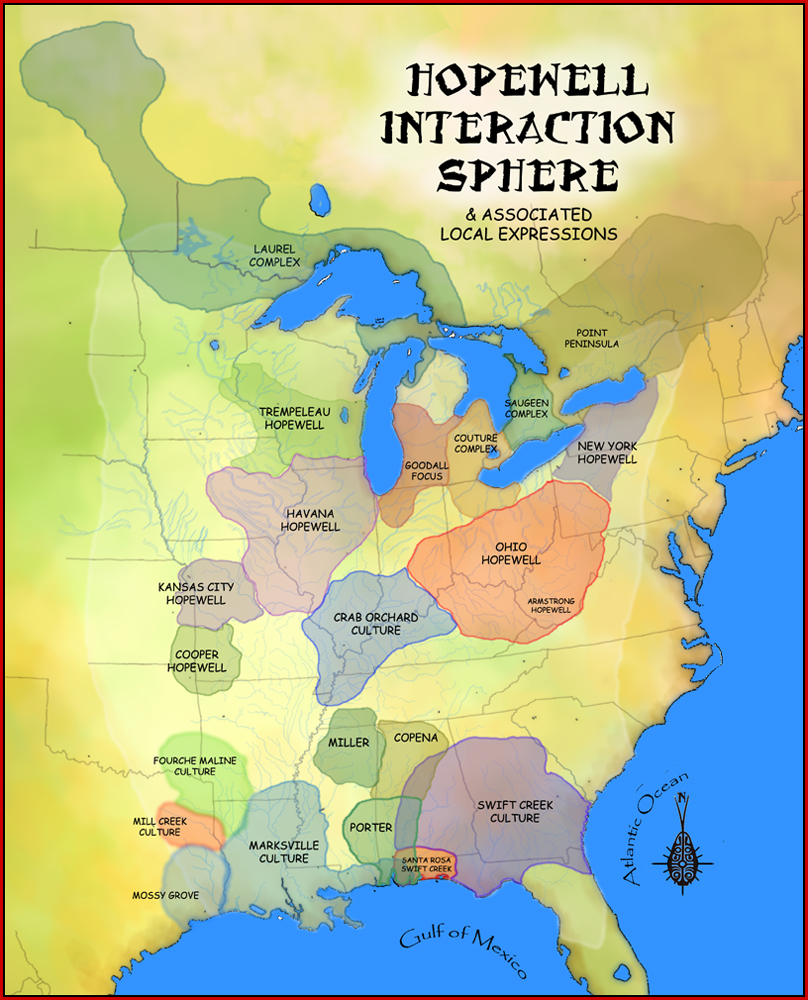
The Laurel complex or Laurel tradition is an archaeological culture which was present in what is now southern Quebec, southern and northwestern Ontario and east-central Manitoba in Canada, and northern Michigan, northwestern Wisconsin and northern Minnesota in the United States. They were the first pottery using people of Ontario north of the Trent–Severn Waterway. The complex is named after the former unincorporated community of Laurel, Minnesota. It was first defined by Lloyd Wilford in 1941. Hopewell Interaction Sphere The Hopewell Exchange system began in the Ohio and Illinois River Valleys about 300 BCE. The culture is referred to more as a system of interaction among a variety of societies than as a single society or culture. Hopewell trading networks were quite extensive, with obsidian from the Yellowstone area, copper from Lake Superior, and shells from the Gulf Coast. The construction of ceremonial mounds was an important feature of the Laurel complex, as it was fo ... [...More Info...] [...Related Items...] OR: [Wikipedia] [Google] [Baidu] |
Voyageurs National Park
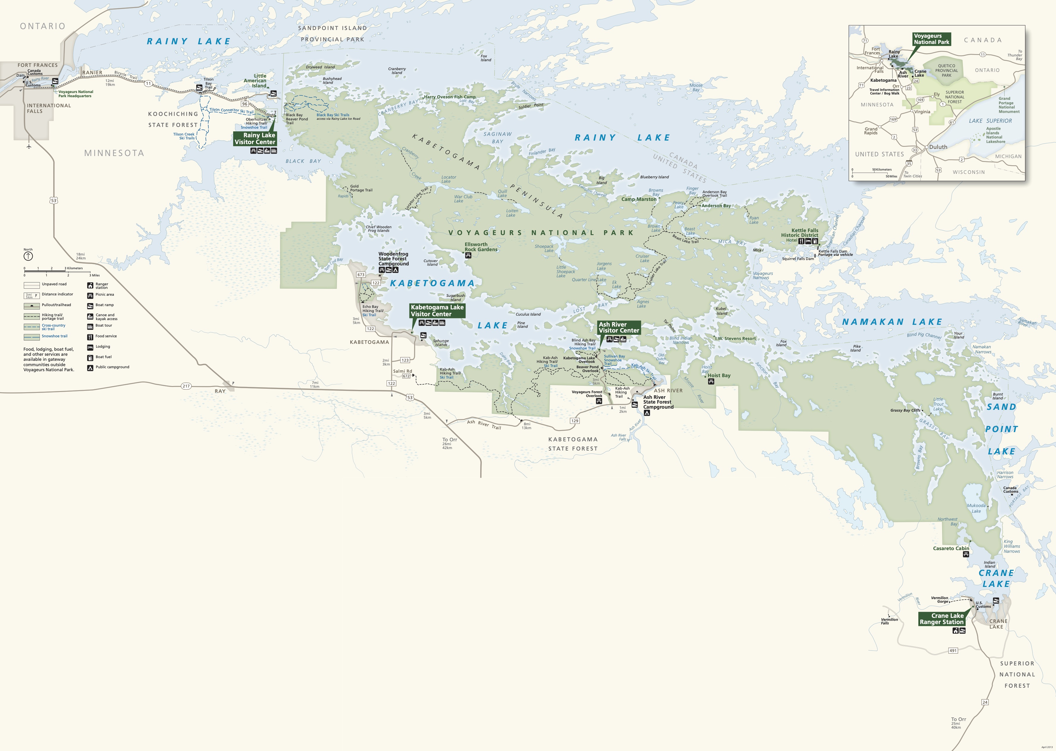
Voyageurs National Park is an American national park in northern Minnesota near the city of International Falls established in 1975. The park's name commemorates the ''voyageurs''—French-Canadian fur traders who were the first European settlers to frequently travel through the area. Notable for its outstanding water resources, the park is popular with canoeists, kayakers, other boaters, and fishermen. The Kabetogama Peninsula, which lies entirely within the park and makes up most of its land area, is accessible only by boat. To the east of the park lies the Boundary Waters Canoe Area Wilderness. The park has several boat ramps and visitor centers on its periphery, though the main body of the park is only accessible by boat or, in the winter, by snowmobile, ski, or snowshoe. In 2018, the park hosted 239,656 visitors. Geology Voyageurs National Park is located on the Canadian Shield, with the rocks averaging between 1 and 3 billion years old. These are some of the oldest r ... [...More Info...] [...Related Items...] OR: [Wikipedia] [Google] [Baidu] |
East Howard Street Commercial Historic District
The East Howard Street Commercial Historic District is a historic business district in Hibbing, Minnesota, United States. It comprises both sides of East Howard Street along the four blocks between 1st and 5th Avenues. It was the new business district designed and built for Hibbing by the Oliver Iron Mining Company from 1920 to 1921, when the company arranged to move the city a mile south to expand the Hull–Rust–Mahoning Open Pit Iron Mine. With The district was listed on the National Register of Historic Places in 1993 for its local significance in the theme of community planning and development. It was nominated as a key portion of Hibbing that represents the efforts of the Oliver Iron Mining Company to relocate the entire town, and the economic importance of iron mining on the Mesabi Range. The historic district consists of 34 contributing properties. Two, the Androy Hotel and the Delvic Building, are also listed individually on the National Register. See also * ... [...More Info...] [...Related Items...] OR: [Wikipedia] [Google] [Baidu] |
Oliver Iron Mining Company
The Oliver Iron Mining Company was a mining company operating in Minnesota, United States. It was one of the most prominent companies in the early decades of mining on the Mesabi Range. As a division of U.S. Steel, Oliver dwarfed its competitors—in 1920, it operated 128 mines across the region, while its largest competitor operated only 65. After the Merritt brothers began shipping iron ore from their Mountain Iron Mine in 1892, Henry W. Oliver, a Pittsburgh businessman, traveled to the Iron Range to consider investing in the fledgling industry. Impressed by what he saw, Oliver offered to purchase one of the ore deposits for $75,000 and 65 cents per ton of ore mined. The Merritts sold Oliver the deposit, and Oliver Iron Mining Company was born. Many early mines on the Mesabi were controlled by East Coast financiers. John D. Rockefeller bought the Merritt brothers' holdings in February 1894. That April, Andrew Carnegie loaned Oliver $500,000 for half of Oliver's stock so he coul ... [...More Info...] [...Related Items...] OR: [Wikipedia] [Google] [Baidu] |
Renaissance Revival Architecture
Renaissance Revival architecture (sometimes referred to as "Neo-Renaissance") is a group of 19th century architectural revival styles which were neither Greek Revival nor Gothic Revival but which instead drew inspiration from a wide range of classicizing Italian modes. Under the broad designation Renaissance architecture nineteenth-century architects and critics went beyond the architectural style which began in Florence and Central Italy in the early 15th century as an expression of Renaissance humanism; they also included styles that can be identified as Mannerist or Baroque. Self-applied style designations were rife in the mid- and later nineteenth century: "Neo-Renaissance" might be applied by contemporaries to structures that others called "Italianate", or when many French Baroque features are present (Second Empire). The divergent forms of Renaissance architecture in different parts of Europe, particularly in France and Italy, has added to the difficulty of defining an ... [...More Info...] [...Related Items...] OR: [Wikipedia] [Google] [Baidu] |
Spanish Colonial Revival Architecture
The Spanish Colonial Revival Style ( es, Arquitectura neocolonial española) is an architectural stylistic movement arising in the early 20th century based on the Spanish Colonial architecture of the Spanish colonization of the Americas. In the United States, the Panama-California Exposition of 1915 in San Diego, highlighting the work of architect Bertram Goodhue, is credited with giving the style national exposure. Embraced principally in California and Florida, the Spanish Colonial Revival movement enjoyed its greatest popularity between 1915 and 1931. In Mexico, the Spanish Colonial Revival in architecture was tied to the nationalist movement in arts encouraged by the post- Mexican Revolution government. The Mexican style was primarily influenced by the Baroque architecture of central New Spain, in contrast to the U.S. style which was primarily influenced by the northern missions of New Spain. Subsequently, the U.S. interpretation saw popularity in Mexico and was locally ... [...More Info...] [...Related Items...] OR: [Wikipedia] [Google] [Baidu] |
Colonial Revival Architecture
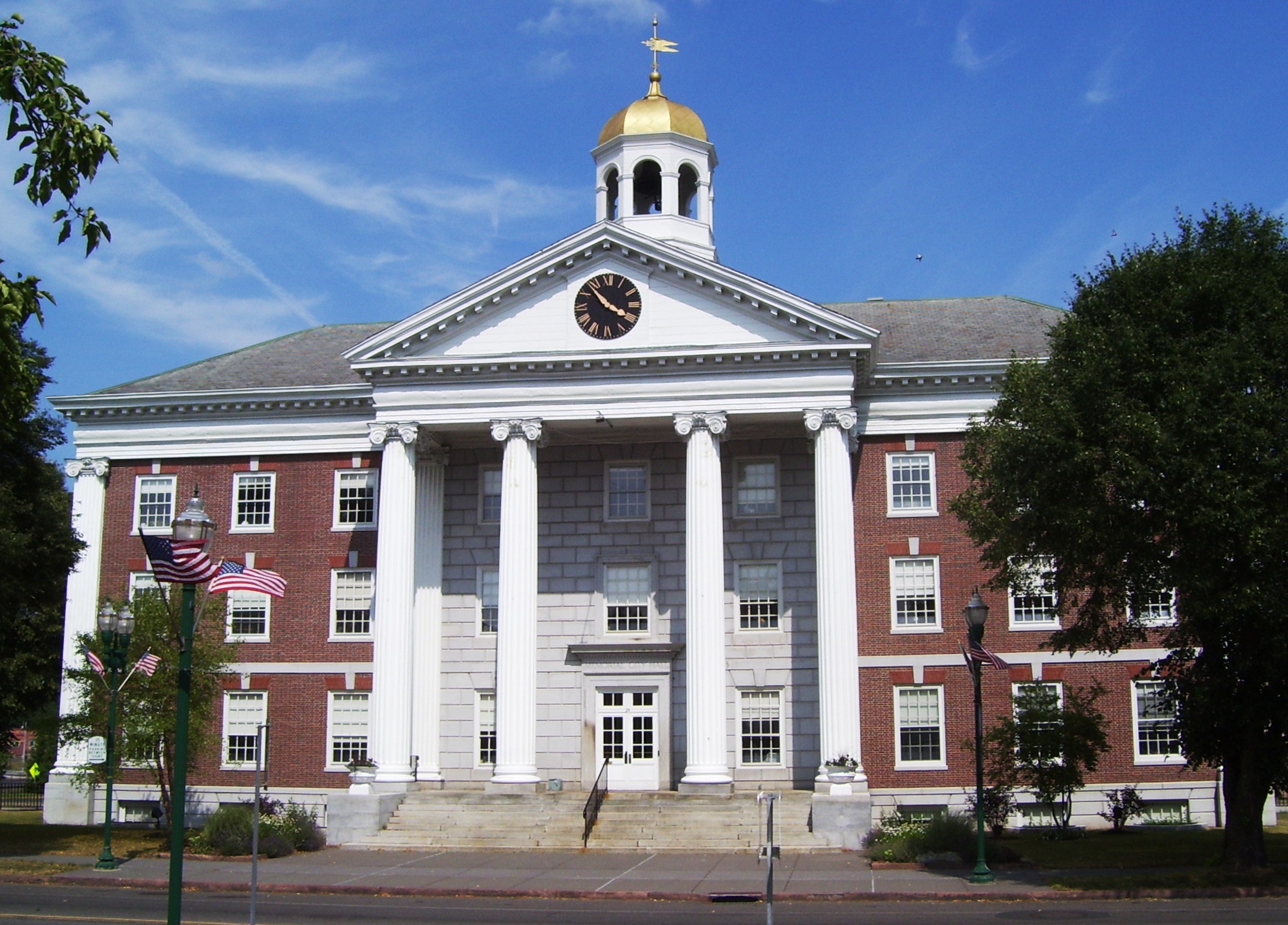
The Colonial Revival architectural style seeks to revive elements of American colonial architecture. The beginnings of the Colonial Revival style are often attributed to the Centennial Exhibition of 1876, which reawakened Americans to the architectural traditions of their colonial past. Fairly small numbers of Colonial Revival homes were built c. 1880–1910, a period when Queen Anne-style architecture was dominant in the United States. From 1910–1930, the Colonial Revival movement was ascendant, with about 40% of U.S. homes built during this period in the Colonial Revival style. In the immediate post-war period (c. 1950s–early 1960s), Colonial Revival homes continued to be constructed, but in simplified form. In the present-day, many New Traditional homes draw from Colonial Revival styles. While the dominant influences in Colonial Revival style are Georgian and Federal architecture, Colonial Revival homes also draw, to a lesser extent, from the Dutch Colonial ... [...More Info...] [...Related Items...] OR: [Wikipedia] [Google] [Baidu] |


