|
Nuristan
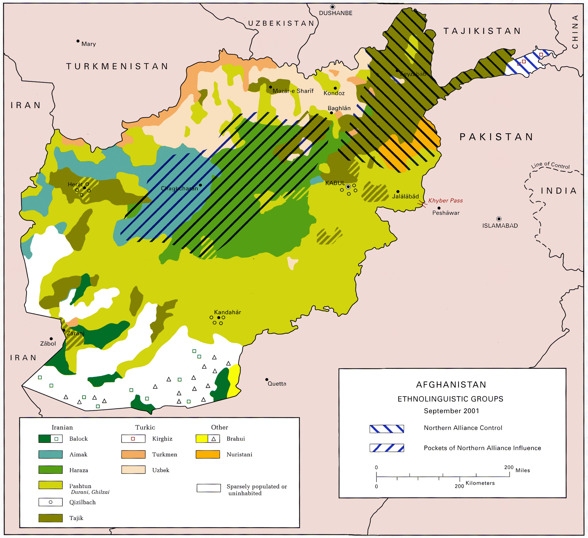
Nuristan, also spelled as Nurestan or Nooristan (Pashto: ; Katë: ), is one of the 34 provinces of Afghanistan, located in the eastern part of the country. It is divided into seven districts and is Afghanistan's least populous province, with a population of around 167,000. Parun serves as the provincial capital. Nuristan is bordered on the south by Laghman and Kunar provinces, on the north by Badakhshan province, on the west by Panjshir province, and on the east by Pakistan. The origin of the local Nuristani people has been disputed, ranging from being the indigenous inhabitants forced to flee to this region after refusing to surrender to invaders, to being linked to various ancient groups of people and the Turk Shahi kings. Some Nuristanis claim being descendants of the Greek occupying forces of Alexander the Great. It was formerly called Kafiristan () ("Land of the Infidels") until the inhabitants were forcibly converted from an animist religion with elements from I ... [...More Info...] [...Related Items...] OR: [Wikipedia] [Google] [Baidu] |
Nuristani Languages
The Nuristani languages are one of the three groups within the Indo-Iranian languages, Indo-Iranian language family, alongside the Indo-Aryan languages, Indo-Aryan and Iranian languages, Iranian languages. They have approximately 214,000 speakers primarily in Nuristan and Kunar Province, Kunar provinces in northeastern Afghanistan and a few adjacent valleys in Khyber Pakhtunkhwa's Chitral District, Pakistan. The region inhabited by the Nuristanis is located in the southern Hindu Kush mountains, and is drained by the Alingar River in the west, the Pech River in the center, and the Landai Sin River, Landai Sin and Kunar River, Kunar rivers in the east. More broadly, the Nuristan region is located at the northern intersection of the Indian subcontinent and the Iranian plateau. The Nuristani languages were not described in literature until the 19th century. The older name for the region was Kafiristan due to the pre-Islamic religious practices of its residents, but this term has been ... [...More Info...] [...Related Items...] OR: [Wikipedia] [Google] [Baidu] |
Nuristanis
The Nuristanis are an Indo-Iranian ethnic group native to the Nuristan Province (formerly Kafiristan) of northeastern Afghanistan and Chitral District of northwestern Pakistan. Their languages comprise the Nuristani branch of Indo-Iranian languages. In the mid-1890s, after the establishment of the Durand Line when Afghanistan and the British Indian Empire reached an agreement regarding the Indo-Afghan border as the region of Kafiristan became part of the Great Game and for a period of time, Emir Abdur Rahman Khan conducted a military campaign to secure the eastern regions and followed up his conquest by imposition of Islam; the region thenceforth being known as ''Nuristan'', the "Land of Light". Before their conversion, the Nuristanis practised an Indo-Iranian (Vedic- or Hindu-like) religion. Non-Muslim religious practices endure in Nuristan today to some degree as folk customs. In their native rural areas, they are often farmers, herders, and dairymen. The Nuristan regio ... [...More Info...] [...Related Items...] OR: [Wikipedia] [Google] [Baidu] |
Katë Language
Katë, also known as Kati or Kamkata-vari, is a Nuristani languages, Nuristani language. It is a dialect continuum comprising three separate dialects spoken mostly in Afghanistan, with additional speakers in the Chitral District of Pakistan deriving from recent migrations a century ago. The ''Kata-vari'' (comprising Western and Northeastern) and ''Kamviri'' (comprising Southeastern) dialects are sometimes erroneously reckoned as two separate languages, but according to linguist Richard Strand they form one language. The Katë language is the largest Nuristani language, spoken by 40,000–60,000 people, from the Kata (people), Kata, Kom people (Afghanistan), Kom, Mumo, Kshto and some smaller Nuristani people, Black-Robed tribes in parts of Afghanistan and Pakistan. The most used alternative names for the language are ''Kati'' or ''Bashgali''. A descriptive grammar of Katë was written by Jakob Halfmann in 2024. Name The name, pronounced , is the ethnonym of the Kata people. Cog ... [...More Info...] [...Related Items...] OR: [Wikipedia] [Google] [Baidu] |
Kafiristan
Kāfiristān, or Kāfirstān (; ; ), is a historical region that covered present-day Nuristan Province in Afghanistan and its surroundings. This historic region lies on, and mainly comprises, the basins of the rivers Alingar, Pech (Kamah), Landai Sin and Kunar, and the intervening mountain ranges. It is bounded by the main range of the Hindu Kush on the north, Pakistan's Chitral District to the east, the Kunar Valley in the south and the Alishang River in the west. Kafiristan took its name from the enduring kafir (non-Muslim) Nuristani inhabitants who once practised what authors consider as a form of animism and ancestor worship with elements of Indo-Iranian ( Vedic- or Hindu-like) religion; they were thus known to the surrounding predominantly Sunni Muslim population as Kafirs, meaning "disbelievers" or "infidels". They are closely related to the Kalash people, an independent people with a distinctive culture, language and religion, who reside in the Chitral District ... [...More Info...] [...Related Items...] OR: [Wikipedia] [Google] [Baidu] |
Districts Of Afghanistan
The districts of Afghanistan, known as ''wuleswali'' (, ''wuləswāləi''; , ''wuləswālī''; ''ulasvolik''), are secondary-level administrative units, one level below Provinces of Afghanistan, provinces. The Afghan government issued its first district map in 1973. It recognized 325 districts, counting ''wuleswalis'' (districts), ''alaqadaries'' (sub-districts), and ''markaz-e-wulaiyat'' (provincial center districts). In the ensuing years, additional districts have been added through splits, and some eliminated through merges. In June 2005, the Afghan government issued a map of 398 districts. It was widely adopted by many information management systems, though usually with the addition of ''Sharak-e-Hayratan'' for 399 districts in total. It remains the ''de facto'' standard as of late 2018, despite a string of government announcements of the creation of new districts. The latest announced set includes 421 districts. The country's Central Statistics Office (CSO) and the Indepe ... [...More Info...] [...Related Items...] OR: [Wikipedia] [Google] [Baidu] |
Languages Of Afghanistan
Afghanistan is a linguistically diverse nation with upwards of 40 distinct languages spoken. Dari and Pashto serve as the two main official languages. Dari historically served as the ''lingua franca'' between different ethnic groups, particularly in the north and west and many big cities, while Pashto is the dominant language in the south and east. Dari is spoken by over 75% of the population in Afghanistan, followed by Pashto 48%, Uzbek 11%, English 6%, Turkmen 3%, Urdu 3%, Pashayi 1%, Nuristani 1%, Arabic 1%, and Balochi 1% (2020 est). Data represents the most widely-spoken languages; shares sum to more than 100% because there is much bilingualism in the country and because respondents were allowed to select more than one language. The Turkic languages, Uzbek and Turkmen, as well as Balochi, Pashayi, Nuristani, and Pamiri are the third official languages in areas where the majority speaks them. Both Farsi (Persian) and Pashto are Indo-European languages from the Iran ... [...More Info...] [...Related Items...] OR: [Wikipedia] [Google] [Baidu] |
Kunar Province
Kunar (Pashto: ; Dari: ) is one of the 34 provinces of Afghanistan, located in the northeastern part of the country. Its capital is Asadabad. Its population is estimated to be 508,224. Kunar's major political groups include Wahhabis or Ahl-e- Hadith, ''Nazhat-e Hambastagi Milli, Hezb-e Afghanistan Naween, Hezb-e Islami Gulbuddin''. It is one of the four " N2KL" provinces (Nangarhar Province, Nuristan Province, Kunar Province and Laghman Province). N2KL was the designation used by the US and Coalition Forces in Afghanistan for the rugged region along the Afghanistan–Pakistan border opposite Pakistan's Federally Administered Tribal Areas (merged in 2018 with Khyber Pakhtunkhwa). Kunar is the center of the N2KL region. Kunar, along with Nuristan, was part of the borderlands known as Kafiristan, and until a few decades ago, it was never considered a true part of Afghanistan. Kunar is a sparsely populated, mountainous, forested border area. Geography Kunar province is loca ... [...More Info...] [...Related Items...] OR: [Wikipedia] [Google] [Baidu] |
List Of Governors Of Nuristan
This is a list of the governors of the province of Nuristan, Afghanistan. Governors of Nuristan Province See also * List of current governors of Afghanistan Notes {{Nuristan Province Nuristan Nuristan, also spelled as Nurestan or Nooristan (Pashto: ; Katë: ), is one of the 34 provinces of Afghanistan, located in the eastern part of the country. It is divided into seven districts and is Afghanistan's least populous province, with a ... * ... [...More Info...] [...Related Items...] OR: [Wikipedia] [Google] [Baidu] |
Parun
Parun (, , ), also called Prasûn and Prasungul, is a small town and administrative center of Nuristan Province and its Parun District in Afghanistan. The city of Parun has a population of 1,647. It has 1 district and a total land area of 350 hectares. The total number of dwellings in Parun is 183. On 15 August 2021, Parun was seized by Taliban fighters, becoming the thirty-second provincial capital to be captured by the Taliban as part of the wider 2021 Taliban offensive. Land use Parun is a village in northeastern Afghanistan with only 350 hectares and 183 dwellings. It is predominantly forest land (54%) followed by agriculture (33%). Built-up land only accounts for 7% of total land use. But unlike many other cities, Parun does not have any barren land and only 4 hectares of vacant plots. Geography Parun has 6 villages: Ishtewi, Pronz, Dewa, Kushteki, Tsutsum and Pashki. They are located over a distance of 20 km from north to south along the Parun River. Ishtewi ... [...More Info...] [...Related Items...] OR: [Wikipedia] [Google] [Baidu] |
Provinces Of Afghanistan
The provinces of Afghanistan ( ''Wilayah, wilāyat'') are the primary administrative divisions. Afghanistan is divided into 34 provinces. Each province encompasses a number of Districts of Afghanistan, districts or usually over 1,000 villages. Provincial governors played a critical role in the reconstruction of the Afghan state following the creation of the new government under Hamid Karzai. According to international security scholar Dipali Mukhopadhyay, many of the provincial governors of the western-backed government were former warlords who were incorporated into the political system. Provinces of Afghanistan Administrative The following table lists the province, capital, number of districts, UN region, region, ISO 3166-2:AF code and license plate code. Demographic The following table lists the province, population in 2024, area in square kilometers and population density. Regions of Afghanistan The following tables summarize data from the demographic ... [...More Info...] [...Related Items...] OR: [Wikipedia] [Google] [Baidu] |
Laghman Province
Laghman (Persian language, Persian/Pashto: ) is one of the 34 provinces of Afghanistan, located in the eastern part of the country. It has a population of about 502,148, which is multi-ethnic and mostly a rural society. Laghman hosts a large number of historical landmarks, minarets, monuments, and other cultural relics that are manifestation of its old history and culture. The city of Mihtarlam serves as the capital of the province. In some historical texts the name is written as "Lamghan" or as "Lamghanat". In 2021, the Taliban gained control of the province during the 2021 Taliban offensive. Etymology Laghman or Lamghan is originally named after Lamech (father of Noah), Lamech (Mether Lam Baba), the father of Noah. History Located currently at the Kabul Museum are Aramaic inscriptions that were found in Laghman which indicated an ancient trade route from India to Palmyra. Aramaic was the bureaucratic script language of the Achaemenids whose influence had extended toward Lag ... [...More Info...] [...Related Items...] OR: [Wikipedia] [Google] [Baidu] |


