|
List Of The Oldest Buildings In Arizona
This article lists the oldest extant buildings in Arizona, including extant buildings and structures constructed during Spanish, Mexican, and early American rule over Arizona. Only buildings built prior to 1850 are suitable for inclusion on this list, or the building must be the oldest of its type. In order to qualify for the list, a structure must: * be a recognizable building (defined as any human-made structure used or intended for supporting or sheltering any use or continuous occupancy); * incorporate features of building work from the claimed date to at least in height and/or be a listed building. This consciously excludes ruins of limited height, roads and statues. Bridges may be included if they otherwise fulfill the above criteria. Dates for many of the oldest structures have been arrived at by radiocarbon dating or dendrochronology and should be considered approximate. If the exact year of initial construction is estimated, it will be shown as a range of dates. List ... [...More Info...] [...Related Items...] OR: [Wikipedia] [Google] [Baidu] |
Spanish California
The history of California can be divided into the Native American period (about 10,000 years ago until 1542), the European exploration period (1542–1769), the Spanish colonial period (1769–1821), the Mexican period (1821–1848), and United States statehood (September 9, 1850–present). California was one of the most culturally and linguistically diverse areas in pre-Columbian North America. After contact with Spanish explorers, most of the Native Americans died out from foreign diseases and genocide campaigns. After the Portolá expedition of 1769–70, Spanish missionaries began setting up 21 California missions on or near the coast of Alta (Upper) California, beginning with the Mission San Diego de Alcala near the location of the modern day city of San Diego, California. During the same period, Spanish military forces built several forts ('' presidios'') and three small towns (''pueblos''). Two of the pueblos would eventually grow into the cities of Los Angeles an ... [...More Info...] [...Related Items...] OR: [Wikipedia] [Google] [Baidu] |
Camp Verde, Arizona
Camp Verde ( yuf-x-yav, ʼMatthi:wa; Western Apache: Gambúdih) is a town in Yavapai County, Arizona, United States. As of the 2010 census, the population of the town is 10,873. The town hosts an annual corn festival in July, sponsored and organized by Hauser and Hauser Farms. Other annual festivals include Fort Verde Days (October); the Pecan, Wine and Antiques Festival (February); and the Crawdad Festival (June). Geography The town is bisected by I-17, extending to the west and to the east of the interstate. Highway 260 connects Camp Verde with Payson to the east and Cottonwood to the west. Three freeway exits provide local access: Exits 285, 287, and 289. The town's historic downtown is approximately from I-17 and contains a grocery store, physician facilities, shopping, dining, historical museum, Fort Verde State Historic Park, chamber of commerce/visitor center and town offices. Camp Verde is located at (34.5667, -111.8562). According to the United States Censu ... [...More Info...] [...Related Items...] OR: [Wikipedia] [Google] [Baidu] |
Sierra Ancha Dwellings
Sierra (Spanish for "mountain range" and " saw", from Latin '' serra'') may refer to the following: Places Mountains and mountain ranges * Sierra de Juárez, a mountain range in Baja California, Mexico * Sierra de las Nieves, a mountain range in Andalusia, Spain * Sierra Madre (other), various mountain ranges ** Sierra Madre (Philippines), a mountain range in the east of Luzon, Philippines * Sierra mountains (other) * Sierra Nevada, a mountain range in the U.S. states of California and Nevada * Sierra Nevada (Spain), a mountain range in Andalusia, Spain * Sierra de San Pedro Mártir, a mountain range in Baja California, Mexico * Sierra Maestra, a mountain range in Cuba Other places Africa * Sierra Leone, a country located on the coast of West Africa Asia * Sierra Bullones, Bohol, Philippines Europe * Sierra Nevada National Park (Spain), Andalusia, Spain * Sierra Nevada Observatory, Granada, Spain North America * High Sierra Trail, California, United Sta ... [...More Info...] [...Related Items...] OR: [Wikipedia] [Google] [Baidu] |
Sierra Ancha Cliff Dwellings
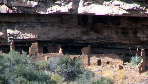
The Sierra Ancha Cliff Dwellings are a series of Pre-Columbian native American cliff-dwellings located in the Sierra Ancha Wilderness. They were built between 1280 and 1350, likely by the Salado people. The Sierra Ancha is home to several prominent ruin sites known as the Devil's Chasm Fortress, the Canyon Creek Ruins, the Pueblo Canyon Ruins, the Cold Springs Canyon Ruins, and the Cooper Forks Canyon Ruins. Collectively they have been called the Cherry Creek Ruins. See also * Cliff Palace * Montezuma's Castle * Cherry Creek Campaign * List of the oldest buildings in Arizona This article lists the oldest extant buildings in Arizona, including extant buildings and structures constructed during Spanish, Mexican, and early American rule over Arizona. Only buildings built prior to 1850 are suitable for inclusion on this ... References {{Cliff dwellings Cliff dwellings Ancient Puebloan archaeological sites in Arizona ... [...More Info...] [...Related Items...] OR: [Wikipedia] [Google] [Baidu] |
Kayenta, Arizona
Kayenta ( nv, ) is a U.S. town which is part of the Navajo Nation and is in Navajo County, Arizona, United States. Established November 13, 1986, the Kayenta Township is the only "township" existing under the laws of the Navajo Nation, making it unique in this way. The population was 5,189 at the 2010 census. Kayenta is located south of Monument Valley and contains a number of hotels and motels which serve visitors to Monument Valley. Like other places on the Navajo Nation, it is illegal to serve alcohol. Arizona does not observe Daylight Time; however, the Navajo reservation does. Kayenta Township is the only municipal-style government on the Navajo Nation. It is regarded as a political sub-division of the Navajo Nation. It is managed by a five-member elected town board, which hires the township manager. Kayenta is the name for the Chapter, as well as the township. Kayenta Chapter (a political division within the Navajo Nation that is analogous to a county within a state) e ... [...More Info...] [...Related Items...] OR: [Wikipedia] [Google] [Baidu] |
Keet Seel Closeup , American politician
{{disambig ...
Keet may refer to: * Keet, a name for some types of parakeet * Keet, a young guineafowl * KEET, a television station in California * Keet, an orca * Blauwe Keet, a Dutch hamlet People * BB Keet, Afrikaner theologian * Darren Keet, South African association football player * Jim Keet James Holland Keet (born May 12, 1949), is an American restaurateur and politician in Little Rock, Arkansas, and a former member of the Arkansas House of Representatives and Arkansas Senate. Keet was the Republican nominee for governor of Arkans ... [...More Info...] [...Related Items...] OR: [Wikipedia] [Google] [Baidu] |
Navajo National Monument
Navajo National Monument is a National Monument located within the northwest portion of the Navajo Nation territory in northern Arizona, which was established to preserve three well-preserved cliff dwellings of the Ancestral Puebloan people: Keet Seel (Broken Pottery) (), Betatakin (Ledge House) (), and Inscription House (). The monument is high on the Shonto plateau, overlooking the Tsegi Canyon system, west of Kayenta, Arizona. It features a visitor center with a museum, three short self-guided trails, two small campgrounds, and a picnic area. The Sandal Trail is an accessible self-guided roundtrip trail that ends at an overlook of the Betatakin ruins across the 560-foot-deep (170 m) Betatakin Canyon. The overlook is the only point in the monument where visitors can view the cliff dwelling other than on the guided tours. Rangers guide visitors on free (3-5 hour long) tours of the Betatakin cliff dwellings and on roundtrip back-country hikes to the Keet Seel. The Inscription ... [...More Info...] [...Related Items...] OR: [Wikipedia] [Google] [Baidu] |
Clarkdale, Arizona
Clarkdale (Yavapai: Saupkasuiva) is a town in Yavapai County, Arizona, United States. The Verde River flows through the town as does Bitter Creek, an intermittent tributary of the river. According to the 2010 census, the population of the town was 4,097. Clarkdale, formerly a mining town, is now largely a retirement community and arts community. History Clarkdale was founded in 1912 as a company smelter town by William A. Clark, for his copper mine in nearby Jerome. Clarkdale was one of the most modern mining towns in the world, including telephone, telegraph, electrical, sewer and spring water services, and was an early example of a planned community. The Clark Mansion, a local landmark, was built in the late 1920s by William Clark III, Clark's grandson and heir to the United Verde Copper Company. The structure, east of town across the Verde River near Pecks Lake, was destroyed in 2010 by a fire of "suspicious" origin. The town center and business district were built in Spa ... [...More Info...] [...Related Items...] OR: [Wikipedia] [Google] [Baidu] |
Sycamore Canyon Cliff Dwelling
Sycamore is a name which has been applied to several types of trees, but with somewhat similar leaf forms. The name derives from the ancient Greek ' (''sūkomoros'') meaning "fig-mulberry". Species of trees known as sycamore: * ''Acer pseudoplatanus'', a species of maple native to central Europe and southwestern Asia * ''Ficus sycomorus'', the sycamore (or sycomore) of the Bible; a species of fig, also called the sycamore fig or fig-mulberry, native to the Middle East and eastern Africa * ''Platanus orientalis'', chinar tree (Old World sycamore) * Some North American members of the genus ''Platanus'', including ** ''Platanus occidentalis'', the American sycamore ** '' Platanus racemosa'', the California sycamore or western sycamore ** ''Platanus wrightii'', the Arizona sycamore ** '' Platanus mexicana''. the Mexican sycamore * In Australia, there are numerous trees which have the common name "sycamore": ** '' Litsea reticulata'' or '' Cryptocarya glaucescens'' (silver sycamore) ** ... [...More Info...] [...Related Items...] OR: [Wikipedia] [Google] [Baidu] |
Globe, Arizona
Globe ( apw, Bésh Baa Gowąh "Place of Metal") is a city in Gila County, Arizona, United States. As of the 2020 census, the population of the city was 7,249. The city is the county seat of Gila County. Globe was founded c. 1875 as a mining camp. Mining, tourism, government and retirees are most important in the present-day Globe economy. The Globe Downtown Historic District was added to the National Register of Historic Places in 1987. Geography Globe is in southern Gila County at (33.399858, −110.781570), in the valley of Pinal Creek, a north-flowing tributary of the Salt River. U.S. Route 60 passes through the city, leading northeast through the Fort Apache Indian Reservation to Show Low, and west to Phoenix. The western terminus of U.S. Route 70 is in Globe at US 60 on the east side of town; US 70 leads southeast through the San Carlos Apache Indian Reservation to Safford and to its eastern terminus at Atlantic, North Carolina. Arizona State Route 77 leads s ... [...More Info...] [...Related Items...] OR: [Wikipedia] [Google] [Baidu] |
Tonto National Monument
Tonto National Monument is a National Monument in the Superstition Mountains, in Gila County of central Arizona. The area lies on the northeastern edge of the Sonoran Desert ecoregion, an arid habitat with annual rainfall of about 16 inches (400 mm). Western Regional Climate Center. The Salt River runs through this area, providing a rare, year-round source of water. Cliff dwellings Well-preserved cliff dwellings were occupied by the |

.png)


