|
Lagrangian Drifter
A drifter (not to be confused with a ''profiling float, float'') is an Oceanography, oceanographic device floating on the surface to investigate ocean currents by tracking location. They can also measure other parameters like sea surface temperature, salinity, barometric pressure, and wave height. Modern drifters are typically tracked by satellite, often GPS. They are sometimes called Lagrangian and Eulerian specification of the flow field, Lagrangian drifters since the location of the measurements they make moves with the flow. A major user of drifters is National Oceanic and Atmospheric Administration, NOAA's Global Drifter Program. Construction principle The major components of a drifter include surface floats for buoyancy, underwater drogues to ensure the drifter follows the movements of the water and is unaffected by wind, instruments (e.g., data collecting instruments, transmitters to transmit the collected data, and GPS devices), and waterproof containers for instruments. ... [...More Info...] [...Related Items...] OR: [Wikipedia] [Google] [Baidu] |
Real-time Data
Real-time data (RTD) is information that is delivered immediately after collection. There is no delay in the timeliness of the information provided. Real-time data is often used for navigation or tracking. Such data is usually data processing, processed using real-time computing although it can also be stored for later or off-line data analysis. Real-time data is not the same as dynamic data. Real-time data can be dynamic (e.g. a variable indicating current location) or static (e.g. a fresh log entry indicating location at a specific time). In economics Real-time economic data, and other official statistics, are often based on preliminary estimates, and therefore are frequently adjusted as better estimates become available. These later adjusted data are called "Official statistics#Data revision, revised data". The terms real-time economic data and real-time economic analysis were coined by Francis X. Diebold and Glenn D. Rudebusch. Macroeconomics, Macroeconomist Glenn D. Rudebusch ... [...More Info...] [...Related Items...] OR: [Wikipedia] [Google] [Baidu] |
Advection
In the fields of physics, engineering, and earth sciences, advection is the transport of a substance or quantity by bulk motion of a fluid. The properties of that substance are carried with it. Generally the majority of the advected substance is also a fluid. The properties that are carried with the advected substance are conserved properties such as energy. An example of advection is the transport of pollutants or silt in a river by bulk water flow downstream. Another commonly advected quantity is energy or enthalpy. Here the fluid may be any material that contains thermal energy, such as water or air. In general, any substance or conserved extensive quantity can be advected by a fluid that can hold or contain the quantity or substance. During advection, a fluid transports some conserved quantity or material via bulk motion. The fluid's motion is described mathematically as a vector field, and the transported material is described by a scalar field showing its distribution ... [...More Info...] [...Related Items...] OR: [Wikipedia] [Google] [Baidu] |
Seaglider
The Seaglider™ is a deep-diving Autonomous Underwater Vehicle (AUV) designed for missions lasting many months and covering thousands of miles. In military applications the Seaglider is more commonly referred to as an Unmanned Underwater Vehicle (UUV). Seaglider was initially developed by the University of Washington (UW) in the 1990s by a team led by professor of oceanography Charles C. Eriksen, with funding primarily from the US Office of Naval Research. In June 2008, iRobot received an exclusive five-year license to produce the Seaglider for customers outside the University of Washington. In May 2013 Kongsberg Underwater Technology, Inc. (part of Kongsberg Maritime) announced that they had completed negotiations with the University of Washington's Center for Commercialization to obtain the sole rights to produce, market and continue the development of Seaglider technology. The Seaglider license was in Kongsberg's subsidiary Hydroid, Inc., which was sold to Huntington Ingalls ... [...More Info...] [...Related Items...] OR: [Wikipedia] [Google] [Baidu] |
20130516DrifterBuoysNOAA
Thirteen or 13 may refer to: * 13 (number) * Any of the years 13 BC, AD 13, 1913, or 2013 Music Albums * ''13'' (Black Sabbath album), 2013 * ''13'' (Blur album), 1999 * ''13'' (Borgeous album), 2016 * ''13'' (Brian Setzer album), 2006 * ''13'' (Die Ärzte album), 1998 * ''13'' (The Doors album), 1970 * ''13'' (Havoc album), 2013 * ''13'' (HLAH album), 1993 * ''13'' (Indochine album), 2017 * ''13'' (Marta Savić album), 2011 * ''13'' (Norman Westberg album), 2015 * ''13'' (Ozark Mountain Daredevils album), 1997 * ''13'' (Six Feet Under album), 2005 * ''13'' (Suicidal Tendencies album), 2013 * ''13'' (Solace album), 2003 * ''13'' (Second Coming album), 2003 * 13 (Timati album), 2013 * ''13'' (Ces Cru EP), 2012 * ''13'' (Denzel Curry EP), 2017 * ''Thirteen'' (CJ & The Satellites album), 2007 * ''Thirteen'' (Emmylou Harris album), 1986 * ''Thirteen'' (Harem Scarem album), 2014 * ''Thirteen'' (James Reyne album), 2012 * ''Thirteen'' (Megadeth album), 2011 * ... [...More Info...] [...Related Items...] OR: [Wikipedia] [Google] [Baidu] |
Wind Vane
A wind vane, weather vane, or weathercock is an list of weather instruments, instrument used for showing the wind direction, direction of the wind. It is typically used as an architectural ornament to the highest point of a building. The word ''vane'' comes from the Old English word , meaning "flag". Although partly functional, wind vanes are generally decorative, often featuring the traditional chicken, cockerel design with letters indicating the points of the compass. Other common motifs include ships, arrows, and horses. Not all wind vanes have pointers. In a sufficiently strong wind, the head of the arrow or cockerel (or equivalent) will indicate the direction from which the wind is blowing. Wind vanes are also found on small wind turbines to keep the wind turbine pointing into the wind. History The oldest known textual references to weather vanes date from 1800-1600 BCE Babylon, where a fable called ''The Fable of the Willow'' describes people looking at a weather vane ... [...More Info...] [...Related Items...] OR: [Wikipedia] [Google] [Baidu] |
Anemometer
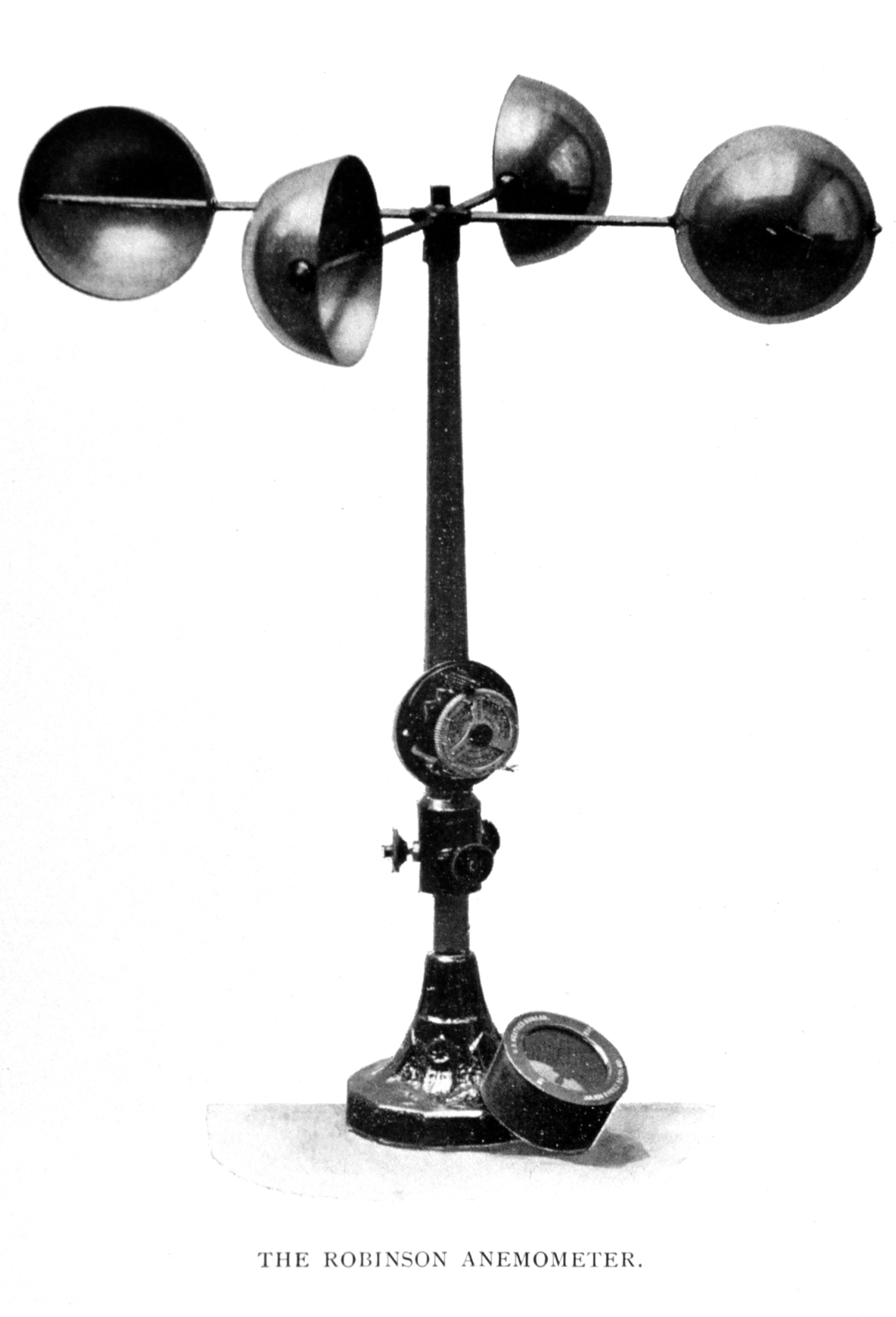
In meteorology, an anemometer () is a device that measures wind speed and direction. It is a common instrument used in weather stations. The earliest known description of an anemometer was by Italian architect and author Leon Battista Alberti (1404–1472) in 1450. History The anemometer has changed little since its development in the 15th century. Alberti is said to have invented it around 1450. In the ensuing centuries numerous others, including Robert Hooke (1635–1703), developed their own versions, with some mistakenly credited as its inventor. In 1846, Thomas Romney Robinson (1792–1882) improved the design by using four hemispherical cups and mechanical wheels. In 1926, Canadian meteorologist John Patterson (1872–1956) developed a three-cup anemometer, which was improved by Brevoort and Joiner in 1935. In 1991, Derek Weston added the ability to measure wind direction. In 1994, Andreas Pflitsch developed the sonic anemometer. Velocity anemometers Cup anemometers ... [...More Info...] [...Related Items...] OR: [Wikipedia] [Google] [Baidu] |
Salinity
Salinity () is the saltiness or amount of salt (chemistry), salt dissolved in a body of water, called saline water (see also soil salinity). It is usually measured in g/L or g/kg (grams of salt per liter/kilogram of water; the latter is dimensionless and equal to per mille, ‰). Salinity is an important factor in determining many aspects of the chemistry of natural waters and of biological processes within it, and is a state function, thermodynamic state variable that, along with temperature and pressure, governs physical characteristics like the density and heat capacity of the water. A contour line of constant salinity is called an ''isohaline'', or sometimes ''isohale''. Definitions Salinity in rivers, lakes, and the ocean is conceptually simple, but technically challenging to define and measure precisely. Conceptually the salinity is the quantity of dissolved salt content of the water. Salts are compounds like sodium chloride, magnesium sulfate, potassium nitrate, and sod ... [...More Info...] [...Related Items...] OR: [Wikipedia] [Google] [Baidu] |
Sea Surface Temperature
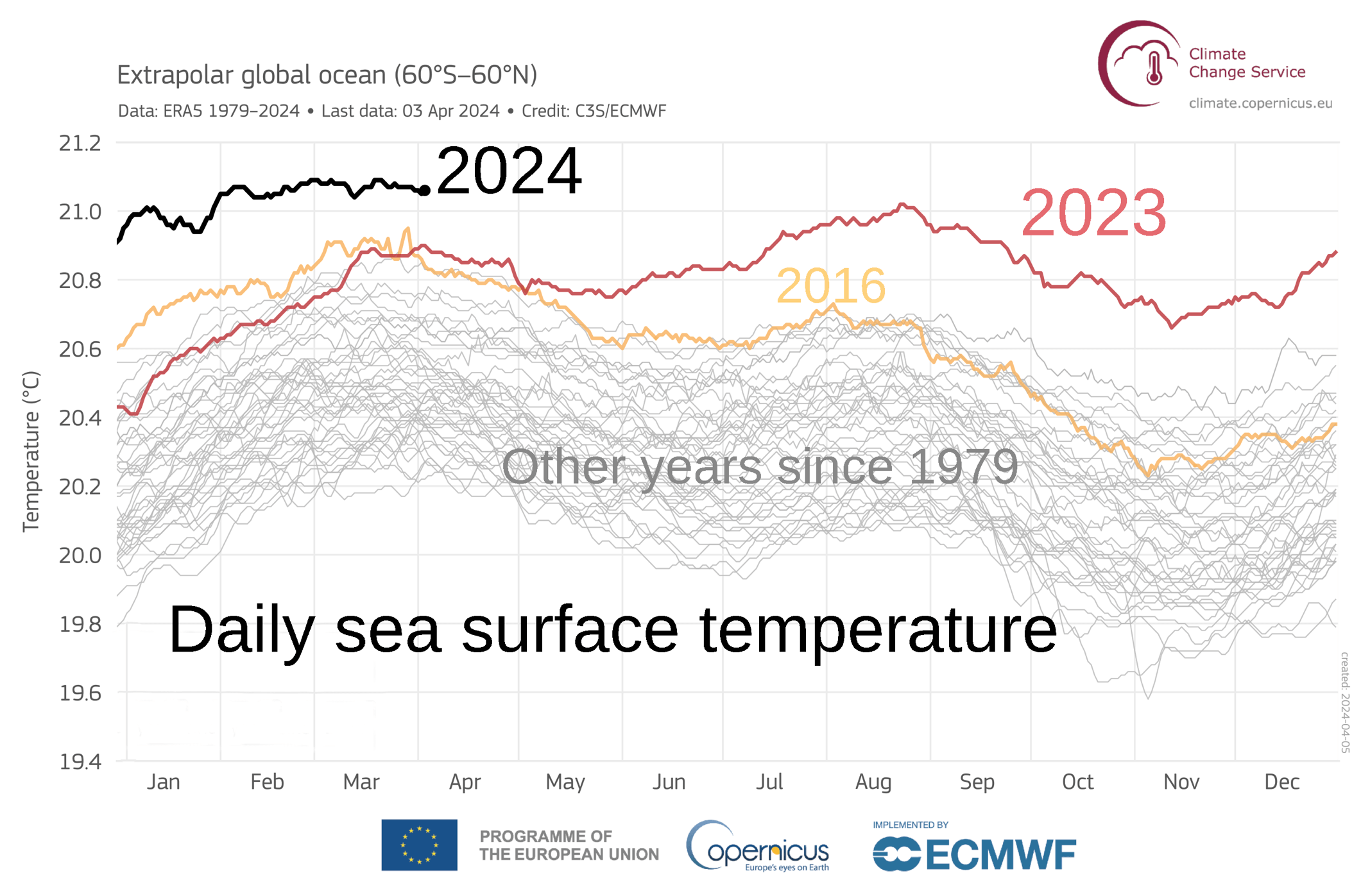
Sea surface temperature (or ocean surface temperature) is the ocean temperature, temperature of ocean water close to the surface. The exact meaning of ''surface'' varies in the literature and in practice. It is usually between and below the sea surface. Sea surface temperatures greatly modify air masses in the Atmosphere of Earth, Earth's atmosphere within a short distance of the shore. The thermohaline circulation has a major impact on average sea surface temperature throughout most of the world's oceans. Warm sea surface temperatures can develop and Tropical cyclogenesis, strengthen cyclones over the ocean. Tropical cyclones can also cause a cool wake. This is due to turbulent mixing of the upper of the ocean. Sea surface temperature changes during the day. This is like the air above it, but to a lesser degree. There is less variation in sea surface temperature on breezy days than on calm days. Coastal sea surface temperatures can cause offshore winds to generate upwelling ... [...More Info...] [...Related Items...] OR: [Wikipedia] [Google] [Baidu] |
Barometric Pressure
Atmospheric pressure, also known as air pressure or barometric pressure (after the barometer), is the pressure within the atmosphere of Earth. The standard atmosphere (symbol: atm) is a unit of pressure defined as , which is equivalent to 1,013.25 millibars, 760 mm Hg, 29.9212 inchesHg, or 14.696 psi.International Civil Aviation Organization. ''Manual of the ICAO Standard Atmosphere'', Doc 7488-CD, Third Edition, 1993. . The atm unit is roughly equivalent to the mean sea-level atmospheric pressure on Earth; that is, the Earth's atmospheric pressure at sea level is approximately 1 atm. In most circumstances, atmospheric pressure is closely approximated by the hydrostatic pressure caused by the weight of air above the measurement point. As elevation increases, there is less overlying atmospheric mass, so atmospheric pressure decreases with increasing elevation. Because the atmosphere is thin relative to the Earth's radius—especially the dense atmospheric layer at low altitudes ... [...More Info...] [...Related Items...] OR: [Wikipedia] [Google] [Baidu] |
El Niño–Southern Oscillation
El Niño–Southern Oscillation (ENSO) is a global climate phenomenon that emerges from variation in winds and sea surface temperatures over the tropical Pacific Ocean. Those variations have an irregular pattern but do have some semblance of cycles. The occurrence of ENSO is not predictable. It affects the climate of much of the tropics and subtropics, and has links (Teleconnection, teleconnections) to higher-latitude regions of the world. The warming phase of the sea surface temperature is known as "El Niño" and the cooling phase as "La Niña". The Southern Oscillation is the accompanying atmospheric oscillation, which is coupled with the sea temperature change. El Niño is associated with higher than normal air sea level pressure over Indonesia, Australia and across the Indian Ocean to the Atlantic Ocean, Atlantic. La Niña has roughly the reverse pattern: high pressure over the central and eastern Pacific and lower pressure through much of the rest of the tropics and subtrop ... [...More Info...] [...Related Items...] OR: [Wikipedia] [Google] [Baidu] |
Numerical Weather Prediction
Numerical weather prediction (NWP) uses mathematical models of the atmosphere and oceans to weather forecasting, predict the weather based on current weather conditions. Though first attempted in the 1920s, it was not until the advent of computer simulation in the 1950s that numerical weather predictions produced realistic results. A number of global and regional forecast models are run in different countries worldwide, using current weather observations relayed from radiosondes, weather satellites and other observing systems as inputs. Mathematical models based on the same physical principles can be used to generate either short-term weather forecasts or longer-term climate predictions; the latter are widely applied for understanding and projecting climate change. The improvements made to regional models have allowed significant improvements in Tropical cyclone track forecasting, tropical cyclone track and air quality forecasts; however, atmospheric models perform poorly at han ... [...More Info...] [...Related Items...] OR: [Wikipedia] [Google] [Baidu] |


