|
L (SEPTA Metro)
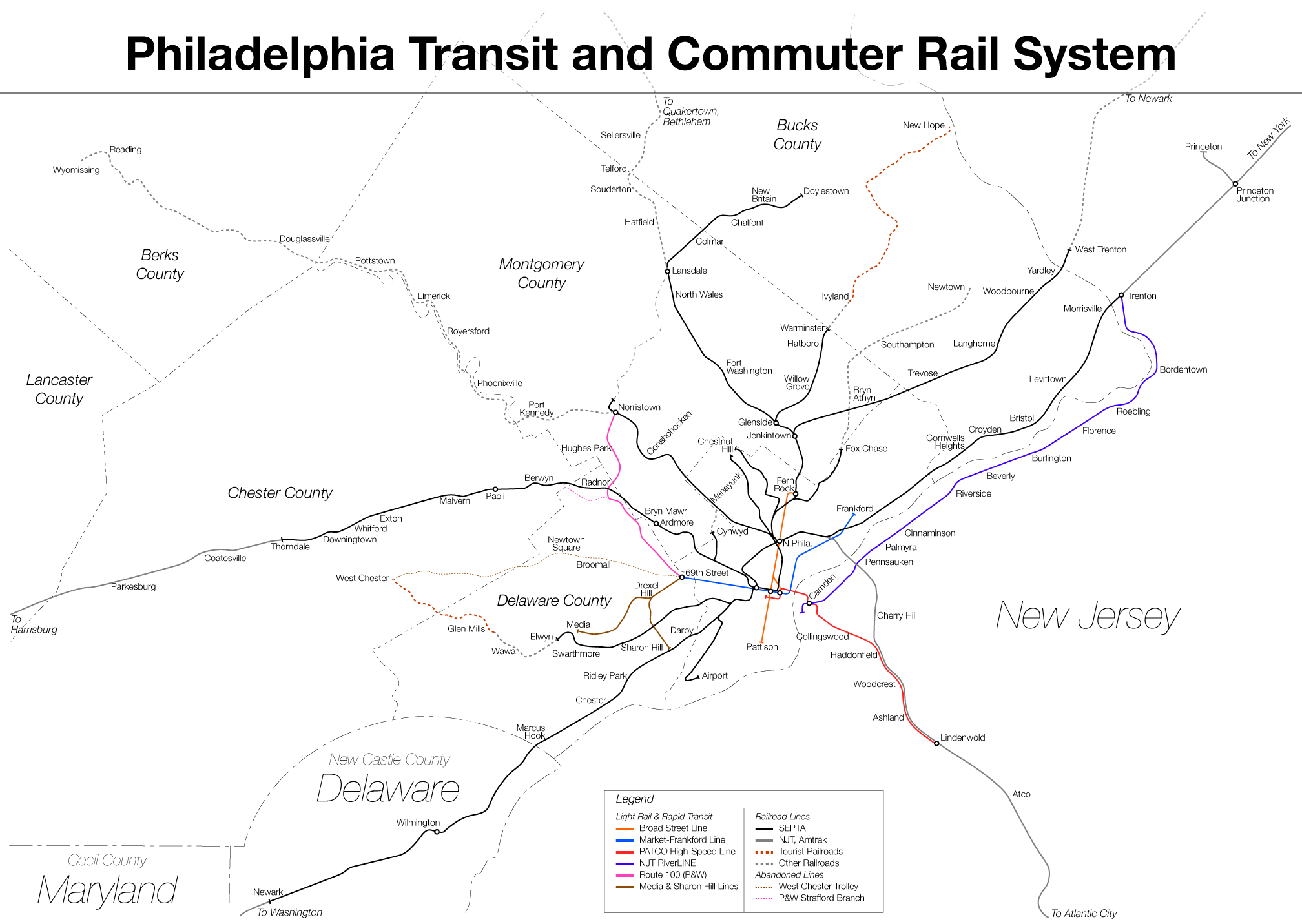
The L, formerly known as the Market–Frankford Line, is a rapid transit line in the SEPTA Metro network in Philadelphia, Pennsylvania, United States. The L runs from the 69th Street Transit Center in Upper Darby, just outside of West Philadelphia, through Center City Philadelphia to the Frankford Transit Center in Near Northeast Philadelphia. Starting in 2024, the line was rebranded as the "L" as part of the implementation of SEPTA Metro, wherein line names are simplified to a single letter. The L is the busiest route in the SEPTA system; it had more than 170,000 boardings on an average weekday in 2019. The line has elevated and underground portions. Route The L begins at 69th Street Transit Center in Upper Darby. The L then heads east at ground level and passes north of the borough of Millbourne. From there, it enters West Philadelphia and is elevated over Market Street until 46th Street, where it curves north and east and then descends underground via a portal at 44th ... [...More Info...] [...Related Items...] OR: [Wikipedia] [Google] [Baidu] |
SEPTA L Icon
SEPTA, the Southeastern Pennsylvania Transportation Authority, is a regional public transportation authority that operates transit bus, bus, rapid transit, commuter rail, light rail, and electric trolleybus services for nearly four million people throughout five counties in and around Philadelphia, Pennsylvania. It also manages projects that maintain, replace, and expand its infrastructure, facilities, and vehicles. SEPTA is the major transit provider for Philadelphia and four surrounding counties within the Philadelphia metropolitan area, including Delaware County, Pennsylvania, Delaware, Montgomery County, Pennsylvania, Montgomery, Bucks County, Pennsylvania, Bucks, and Chester County, Pennsylvania, Chester counties. It is a state-created authority, with the majority of its board appointed by the five counties it serves. Several SEPTA commuter rail and bus services serve New Castle County, Delaware and Mercer County, New Jersey, although service to Philadelphia from South Jers ... [...More Info...] [...Related Items...] OR: [Wikipedia] [Google] [Baidu] |
Center City, Philadelphia
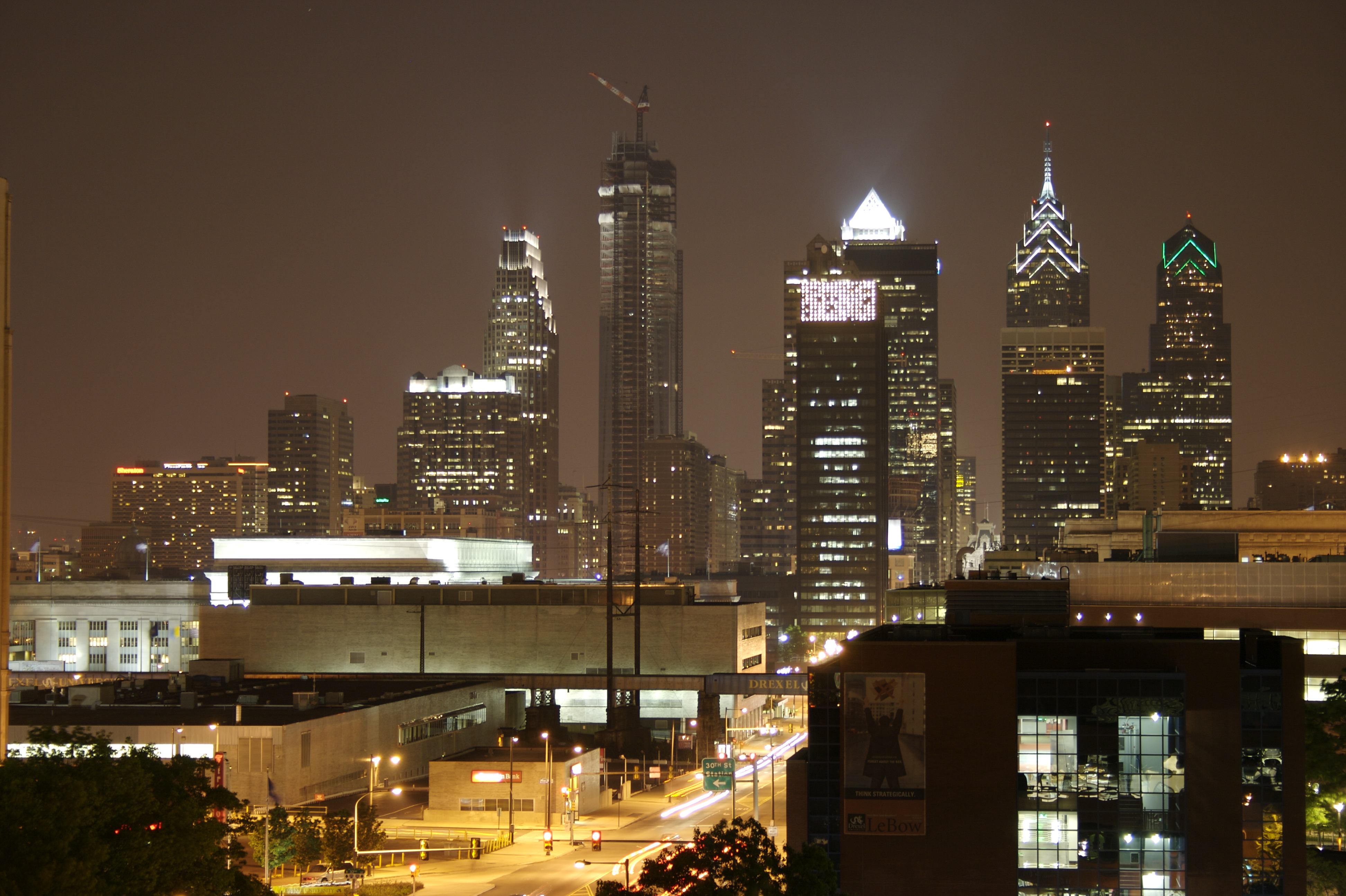
Center City includes the central business district and central neighborhoods of Philadelphia, Pennsylvania, United States. It comprises the area that made up the City of Philadelphia prior to the Act of Consolidation, 1854, which extended the city borders to be coterminous with Philadelphia County, Pennsylvania, Philadelphia County. The area has grown to the second-most densely populated downtown area in the United States (after Midtown Manhattan in New York City), with an estimated 202,000 residents in 2020 and a population density of 26,234 per square mile. Geography Boundaries Center City is bounded by South Street (Philadelphia), South Street to the south, the Delaware River to the east, the Schuylkill River to the west, and Vine Street to the north. The district occupies the old boundaries of the City of Philadelphia before Act of Consolidation, 1854, the city was made coterminous with Philadelphia County in 1854. The Center City District, which has special powers of taxa ... [...More Info...] [...Related Items...] OR: [Wikipedia] [Google] [Baidu] |
Philadelphia City Hall
Philadelphia City Hall is the seat of the municipal government of the City of Philadelphia in the U.S. state of Pennsylvania. Built in the ornate Second Empire style, City Hall houses the chambers of the Philadelphia City Council and the offices of the List of mayors of Philadelphia, Mayor of Philadelphia. This building is also a courthouse, serving as the seat of the First Judicial District of Pennsylvania. It houses the Civil Trial and Orphans' Court Divisions of the Pennsylvania courts of common pleas, Court of Common Pleas of Philadelphia County, Pennsylvania, Philadelphia County. It also houses the Philadelphia facilities for the Supreme Court of Pennsylvania (which also holds session and accepts filings in Harrisburg, Pennsylvania, Harrisburg and Pittsburgh). Built using brick, white marble and limestone, Philadelphia City Hall is the world's largest free-standing masonry building and was the History of the world's tallest buildings, world's tallest habitable building upo ... [...More Info...] [...Related Items...] OR: [Wikipedia] [Google] [Baidu] |
Balloon Loop
A balloon loop, turning loop, or reversing loop ( North American Terminology) allows a rail vehicle or train to reverse direction without having to shunt or stop. Balloon loops can be useful for passenger trains and unit freight trains. Balloon loops are common on tram and streetcar systems. Many streetcar and tram systems use single-ended vehicles that have doors on only one side and controls at only one end. These systems may also haul trailers with no controls in the rear car, and, as such, must be turned at each end of the route. History Balloon loops were first introduced on tram and, later, metro lines. They did not commonly appear on freight railways until the 1960s, when the modernising British Rail system introduced '' merry-go-round'' (MGR) coal trains that operated from mines to power stations and back again without shunting. Tramways On the former Sydney tram system, loops were used from 1881 until the second-generation system's closure in 1961. Initial ... [...More Info...] [...Related Items...] OR: [Wikipedia] [Google] [Baidu] |
Broad Street Line
The B, formerly known as the Broad Street Line (BSL), is a rapid transit line in the SEPTA Metro network in Philadelphia, Pennsylvania, United States. The line runs primarily north-south from the Fern Rock Transit Center in North Philadelphia through Center City Philadelphia to NRG Station at Pattison Avenue in South Philadelphia; the latter station provides access to the stadiums and arenas for the city's major professional sports teams at the South Philadelphia Sports Complex, about a quarter mile away. The trains of the B run underneath Broad Street for almost its entire length. The line, which is entirely underground except for the northern terminus at Fern Rock, has four tracks in a local/express configuration from Fern Rock to Walnut–Locust and two tracks from Lombard-South to the southern terminus at NRG Station. It is one of only two rapid transit lines in the SEPTA Metro system overall alongside the L, though Center City Philadelphia is also served by five st ... [...More Info...] [...Related Items...] OR: [Wikipedia] [Google] [Baidu] |
19th Street Station (SEPTA)
19th Street station is an underground trolley station serving all routes of the SEPTA Metro SEPTA subway–surface trolley lines, T in Philadelphia. It is located underneath Market Street in Center City Philadelphia, Center City. The station was opened by the Philadelphia Transportation Company in 1907. Touches of the original 1907 station, such as columns and railings, still remain. The station lies in the heart of Philadelphia's financial district, steps away from the Philadelphia Stock Exchange and two blocks north of Rittenhouse Square. History The station was built by the Philadelphia Rapid Transit Company (PRT), and for the first two years formed part of a subway–surface trolley loop operating underground between and the Schuylkill River. In 1907, the Market–Frankford Line, Market Street subway–elevated line was completed from 15th Street to . The original line featured a bridge – located north of Market Street and south of Filbert Street – that carried bo ... [...More Info...] [...Related Items...] OR: [Wikipedia] [Google] [Baidu] |
22nd Street Station (SEPTA)
22nd Street station is an underground trolley station in Center City, Philadelphia that serves all lines of the SEPTA Metro T. Similar to 19th Street station, three blocks east of it, the station has two side platforms and a total of four tracks. The station serves only subway–surface trolleys on the two outer tracks; the Market-Frankford Line subway uses the two inner tracks and bypasses the station as it travels between 15th Street and 30th Street station. The station was constructed by the Philadelphia Transportation Company in 1955, a replacement for the nearby 24th Street station just north of Market Street at the east end of the now-removed shared train and trolley bridge over the Schuylkill River. The former station site is now the Crown Lights Building (a tall rectangular black skyscraper topped with four large LED message boards atop its upper sides), the headquarters of PECO Energy. History 22nd Street station was opened October 15, 1955 by the Philadelphia Tr ... [...More Info...] [...Related Items...] OR: [Wikipedia] [Google] [Baidu] |
15th Street/City Hall Station
15th Street/City Hall station is a SEPTA Metro rapid transit complex in Philadelphia, Pennsylvania. The station is located beneath Philly's City Hall building. It is served by the L, the B, and the T. Each of the three lines have their own separate platforms, but there is an interchange to any of the services through an underground concourse referred to by some Philadelphians as "The Labyrinth" due to the underground's confusing navigation. Interchanges A free interchange is available between all of the subway lines here, including the 15th Street platform for the L and the T lines, and the B at City Hall platform. The station is connected to the Center City Concourse, a system of underground passageways, which connects to Suburban Station, which provides access to SEPTA Regional Rail. 15th Street/City Hall station is also connected to the B Walnut–Locust station, which in turn is connected to PATCO Speedline's 12–13th & Locust Station, and 15–16th & Locust S ... [...More Info...] [...Related Items...] OR: [Wikipedia] [Google] [Baidu] |
Schuylkill River
The Schuylkill River ( , ) is a river in eastern Pennsylvania. It flows for U.S. Geological Survey. National Hydrography Dataset high-resolution flowline dataThe National Map(). accessed April 1, 2011. from Pottsville, Pennsylvania, Pottsville southeast to Philadelphia, the nation's sixth-largest city, where it joins the Delaware River as one of its largest tributaries. The river's Drainage basin, watershed of about lies entirely within the state of Pennsylvania, stretching from the Ridge-and-Valley Appalachians through the Piedmont (United States), Piedmont to the Atlantic Plain. Historically the Schuylkill lay within the territory of the Susquehannock and Lenape peoples. In 1682, William Penn founded the city of Philadelphia between the Schuylkill and Delaware rivers on lands purchased from the Lenape Indian tribe. The Schuylkill River became key in the development of the city and the surrounding region. While long used for transport, the river was made fully navigable via ... [...More Info...] [...Related Items...] OR: [Wikipedia] [Google] [Baidu] |
Tram
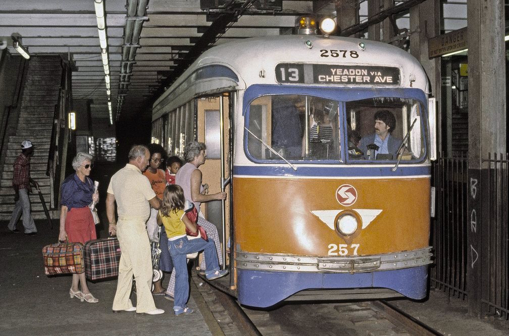
A tram (also known as a streetcar or trolley in Canada and the United States) is an urban rail transit in which Rolling stock, vehicles, whether individual railcars or multiple-unit trains, run on tramway tracks on urban public streets; some include segments on segregated Right-of-way (property access), right-of-way. The tramlines or tram networks operated as public transport are called tramways or simply trams/streetcars. Because of their close similarities, trams are commonly included in the wider term ''light rail'', which also includes systems separated from other traffic. Tram vehicles are usually lighter and shorter than Main line (railway), main line and rapid transit trains. Most trams use electrical power, usually fed by a Pantograph (transport), pantograph sliding on an overhead line; older systems may use a trolley pole or a bow collector. In some cases, a contact shoe on a third rail is used. If necessary, they may have dual power systems—electricity in city stre ... [...More Info...] [...Related Items...] OR: [Wikipedia] [Google] [Baidu] |
Drexel Station At 30th Street
Drexel Station at 30th Street (known as 30th Street station prior to 2024) is an underground SEPTA Metro station in Philadelphia. It is located under Market Street between 30th and 31st streets in the University City neighborhood, adjacent to 30th Street Station and Drexel University. The station features four tracks – the inner pair serving the L and the outer pair for the T. History The station opened on November 6, 1955 by the Philadelphia Transportation Company (PTC), built as a replacement for the elevated 32nd Street station that had opened in 1907 as part of the Philadelphia Rapid Transit Company's original Market Street subway–elevated line from to , which was elevated west of 23rd Street. The PRT announced a project to bury the elevated tracks between 23rd to 46th streets in the 1920s. The tunnel from 23rd to 32nd streets was completed by 1933, but construction on the remaining segment was put on hiatus due to the Great Depression and World War II. The P ... [...More Info...] [...Related Items...] OR: [Wikipedia] [Google] [Baidu] |
SEPTA Subway–surface Trolley Lines
The T, formerly known as the Subway–Surface Trolleys, is a light rail trolley system of the SEPTA Metro serving Philadelphia and Delaware County, Pennsylvania. The system comprises five trolley services that operate on street-level tracks in West Philadelphia and Delaware County, and also underneath Market Street in Philadelphia's Center City. The services— T1, T2, T3, T4, and T5—collectively operate on about of route. Like Boston's Green Line and San Francisco's Muni Metro, the T is the descendant of a pre-World War II streetcar system. It also shares many similarities with the premetro and stadtbahn systems of continental Europe. Where Boston and San Francisco's systems use longer, articulated LRT vehicles, Philadelphia uses rigid vehicles roughly longer than the PCC streetcar they replaced. The lines use Kawasaki Type K LRVs delivered in 1981–82. The cars are similar to those on the Media–Sharon Hill Line 100 series, SEPTA's suburban trolley routes, ... [...More Info...] [...Related Items...] OR: [Wikipedia] [Google] [Baidu] |


