|
Kuttanad
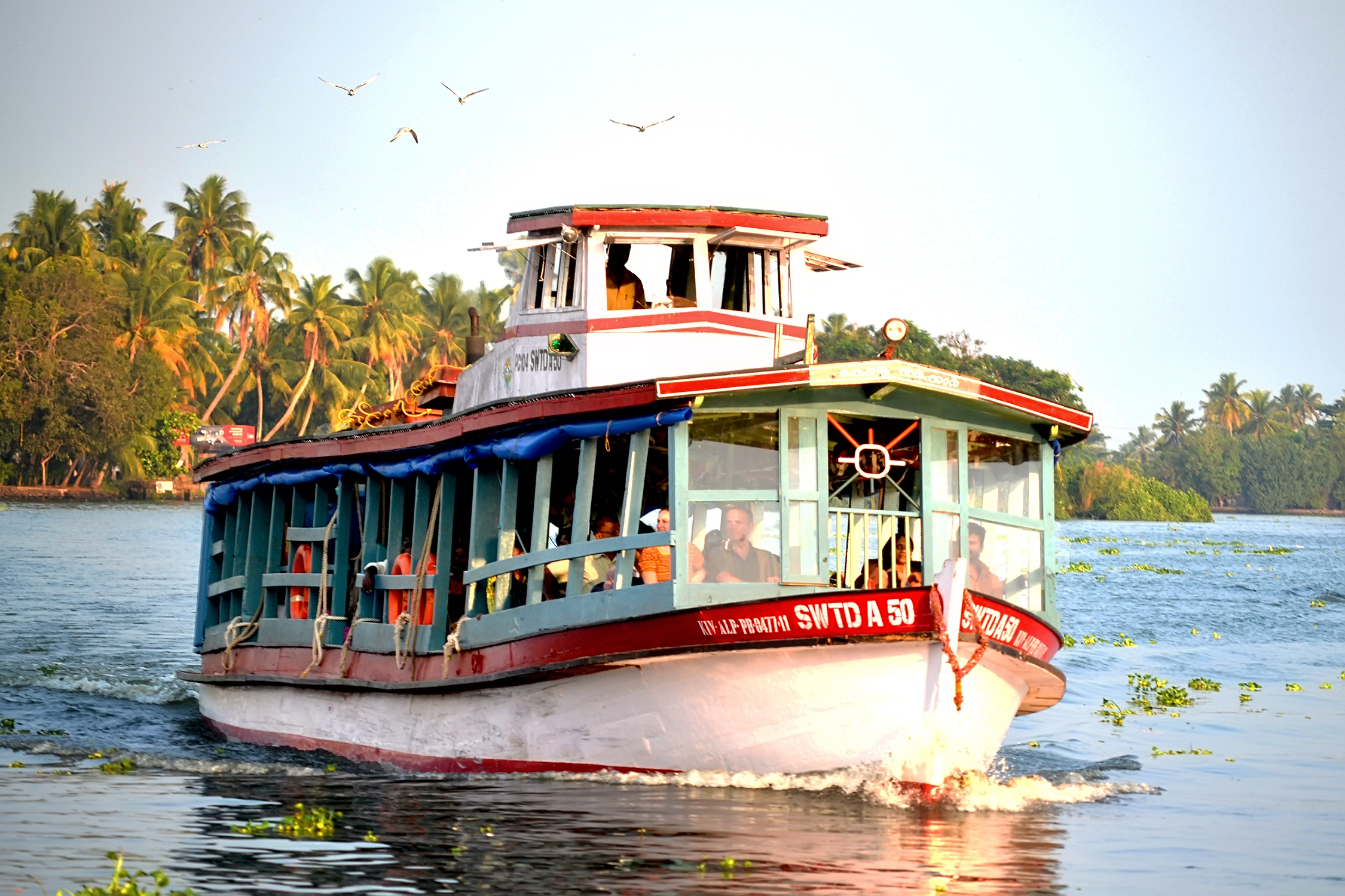
Kuttanad is a river delta landscape region in the state of Kerala, India, known for its vast paddy fields and geographical peculiarities. It is in the Districts of Alappuzha, Kottayam and Pathanamthitta. The region has the lowest altitude in India, and is one of the few places in the world where farming is carried on around below sea level, using rice paddies largely located on reclaimed land amid the delta. Kuttanad is historically important in the ancient history of South India and is the major rice producer in the state. Farmers of Kuttanad are famous for Biosaline Farming. The United Nations Food and Agriculture Organization (FAO) has declared the Kuttanad Farming System as a Globally Important Agricultural Heritage Systems, Globally Important Agricultural Heritage System (GIAHS) in 2013. Four of Kerala's major rivers, the Pamba River, Pamba, Meenachil River, Meenachil, Achankovil and Manimala flow into the region. It is well known for its boat race in the Punnamada Backw ... [...More Info...] [...Related Items...] OR: [Wikipedia] [Google] [Baidu] |
Alappuzha
Alappuzha (, आलप्पुळ) or Alleppey is a municipality and town on the Laccadive Sea in the southern Indian state of Kerala. It is the district headquarters of the district, and is located about north of the state capital Thiruvananthapuram. As per the 2011 Indian census, Alappuzha has a population of 240,991 people, and a population density of . Alappuzha dates back to the Sangam era, and was mentioned by Pliny the Elder as far back as the 1st century AD as "Baraces". Later in the 16th and 17th centuries, the town flourished as an important hub for trading spices with various European powers including the Dutch and the Portuguese. Under the rule of Raja Kesavadas, a port was constructed and canals for transport were laid throughout the city, and the town experienced rapid development. However, by the late 18th century, the region had come under British rule and experienced a decline in its status as a centre for commerce and culture. Today, Alappuzha is a pro ... [...More Info...] [...Related Items...] OR: [Wikipedia] [Google] [Baidu] |
Alappuzha District
Alappuzha district (), is one of the 14 Districts of Kerala, districts in the States and union territories of India, Indian state of Kerala. It was formed as Alleppey district on 17 August 1957, the name of the district being changed to ''Alappuzha'' in 1990. Alappuzha is the smallest district of Kerala. Alleppey town, the district headquarters, was renamed Alappuzha in 2012. A town with canals, Kerala Backwaters, backwaters, Alappuzha Beach, beaches, and lagoons, Alappuzha was described by George Curzon, 1st Marquess Curzon of Kedleston, George Curzon, the British Raj, British Governor-General of India in the beginning of the 20th century CE, as the "Venice of the Eastern world." The district is best known for its picturesque Kerala Backwaters, by which it is well connected to other parts of Kerala, including the tourist destination of Kumarakom, the district being a well known tourist destination in India. It is also known for its Alleppy Coir, coir factories, as most of Keral ... [...More Info...] [...Related Items...] OR: [Wikipedia] [Google] [Baidu] |
Kottayam District
Kottayam () is one of List of districts of Kerala, 14 districts in the States and union territories of India, Indian state of Kerala. Kottayam district comprises six municipal towns: Kottayam, Changanassery, Pala, Kerala, Pala, Erattupetta, Ettumanoor, and Vaikom. Situated in the south-central part of Kerala, Kottayam shares its borders with Ernakulam, Idukki, Pathanamthitta, and Alappuzha districts. It is the only List of districts in India, district in Kerala that does not border either the Arabian Sea or another Indian state. The district is bordered by hills in the east, and the Vembanad Lake and paddy fields of Kuttanad on the west. The area's geographic features include paddy fields, highlands, and hills. As of the 2011 census, 28.6% of the district's residents live in urban areas, and it reports a 97.2% Literacy in India, literacy rate. In 2008, the district became the first tobacco-free district in India. Kottayam registered the lowest Multidimensional Poverty Index (MPI) ... [...More Info...] [...Related Items...] OR: [Wikipedia] [Google] [Baidu] |
Kerala Water Transport DS
Kerala ( , ) is a state on the Malabar Coast of India. It was formed on 1 November 1956, following the passage of the States Reorganisation Act, by combining Malayalam-speaking regions of the erstwhile regions of Cochin, Malabar, South Canara, and Travancore. Spread over , Kerala is the 14th smallest Indian state by area. It is bordered by Karnataka to the north and northeast, Tamil Nadu to the east and south, and the Lakshadweep Sea to the west. With 33 million inhabitants as per the 2011 census, Kerala is the 13th-largest Indian state by population. It is divided into 14 districts with the capital being Thiruvananthapuram. Malayalam is the most widely spoken language and is also the official language of the state. The Chera dynasty was the first prominent kingdom based in Kerala. The Ay kingdom in the deep south and the Ezhimala kingdom in the north formed the other kingdoms in the early years of the Common Era (CE). The region had been a prominent spice exporter sinc ... [...More Info...] [...Related Items...] OR: [Wikipedia] [Google] [Baidu] |
Kerala
Kerala ( , ) is a States and union territories of India, state on the Malabar Coast of India. It was formed on 1 November 1956, following the passage of the States Reorganisation Act, by combining Malayalam-speaking regions of the erstwhile regions of Kingdom of Cochin, Cochin, Malabar District, Malabar, South Canara, and Travancore. Spread over , Kerala is the 14th List of states and union territories of India by area, smallest Indian state by area. It is bordered by Karnataka to the north and northeast, Tamil Nadu to the east and south, and the Laccadive Sea, Lakshadweep Sea to the west. With 33 million inhabitants as per the 2011 Census of India, 2011 census, Kerala is the List of states of India by population, 13th-largest Indian state by population. It is divided into 14 List of districts of Kerala, districts with the capital being Thiruvananthapuram. Malayalam is the most widely spoken language and is also the official language of the state. The Chera dynasty was the f ... [...More Info...] [...Related Items...] OR: [Wikipedia] [Google] [Baidu] |
Achankovil
Achankovil is a long west flowing river in Kerala, India. It flows through the districts of Kollam, Pathanamthitta and Alappuzha. The river drains vast tract of fertile plains of Upper Kuttanad in the Alappuzha and Pathanamthitta districts. It also sustains numerous urban settlements along its course such as Konni, Pathanamthitta, Pandalam and Mavelikkara. Course The river has its origin in Devar Mala peak of the Western Ghats situated in the Konni Reserve Forest. Rivers like Rishimala, Pashukidamettu and Ramakkaltheri form the major tributaries of the Achenkovil river. It flows south west from its origin and enters Kollam district near Achencovil village. Then the river switches its course towards north west and flows almost 20 kms through Kollam district before re-entering Pathanamthitta district near Kalleli. Later it flows through the hilly towns of Konni, Kumbazha, Mylapra, Konnithazham, Vettoor, Pathanamthitta, Pramadam, Vallikode and enters in ... [...More Info...] [...Related Items...] OR: [Wikipedia] [Google] [Baidu] |
Globally Important Agricultural Heritage Systems
The Food and Agriculture Organization, Food and Agriculture Organization of the United Nations (FAO) leads the programme Globally Important Agricultural Heritage Systems (GIAHS), which helps identify ways to mitigate threats faced by these systems and their people and enhance the benefits derived from these dynamic systems. Globally Important Agricultural Heritage Systems recognize remarkable land use systems and landscapes full of life and biodiversity, resilient ecosystems, and valuable cultural heritages managed by farmers, herders, fisherfolk, and forest people. Communities that have preserved and developed complex, diverse, and locally adapted agricultural systems that nowadays provide sustainably many goods and services, food, and livelihood security for millions of people around the world. As of November 2023, the GIAHS Programme has awarded the designation to 86 sites in 26 countries, with 10 additional proposals in queue. List of UN-designated Globally Important Agricul ... [...More Info...] [...Related Items...] OR: [Wikipedia] [Google] [Baidu] |
Chera
The Chera dynasty ( or Cēra, ), also known as Keralaputra, from the early historic or the Sangam period in Tamil-speaking southern India, ruled over parts of present-day states Kerala and Tamil Nadu. The Cheras, known as one of the mu-ventar (the Three Crowned Kings) of Tamilakam (the Tamil Country) alongside the Cholas and Pandyas, have been documented as early as the third century BCE. The Chera country was geographically well placed at the tip of the Indian peninsula to profit from maritime trade via the extensive Indian Ocean networks. Exchange of spices, especially black pepper, with Middle Eastern or Graeco-Roman merchants is attested to in several sources. Chera influence extended over central Kerala and western Tamil Nadu until the end of the early historic period in southern India. The Cheras of the early historical period (c. second century BCE – c. third/fifth century CE) had their capital in interior Tamil country ( Vanchi-Karur, Kongu Nadu), and ports/capitals ... [...More Info...] [...Related Items...] OR: [Wikipedia] [Google] [Baidu] |
Pamba River
The Pamba River (also called Pampa River) is the longest river in the Indian state of Kerala after Periyar (river), Periyar and Bharathappuzha, and the longest river in the erstwhile former princely state of Travancore. The Sabarimala Temple, dedicated to Ayyappa, Lord Ayyappa, is located on the banks of the river Pamba. The River Pamba enriches the lands of Pathanamthitta District, Pathanamthitta district and the Kuttanad area of Alappuzha District, Alappuzha district and Kottayam Course The Pamba originates at the Pulachimalai Hill in the Peerumedu Plateau in the Western Ghats at an altitude of . Starting from the Idukki district and traversing a distance of through Pathanamthitta and Alappuzha districts, the river joins the Arabian Sea through a number of channels. The basin extends over an area of with the entire catchment area within Kerala state. The basin is bounded on the east by the Western Ghats and on the west by the Arabian Sea. The river shares its northern boun ... [...More Info...] [...Related Items...] OR: [Wikipedia] [Google] [Baidu] |
Chera Dynasty
The Chera dynasty ( or Cēra, ), also known as Keralaputra, from the early historic or the Sangam period in Tamil-speaking southern India, ruled over parts of present-day states Kerala and Tamil Nadu. The Cheras, known as one of the mu-ventar (the Three Crowned Kings) of Tamilakam (the Tamil Country) alongside the Cholas and Pandyas, have been documented as early as the third century BCE. The Chera country was geographically well placed at the tip of the Indian peninsula to profit from maritime trade via the extensive Indian Ocean networks. Exchange of spices, especially black pepper, with Middle Eastern or Graeco-Roman merchants is attested to in several sources. Chera influence extended over central Kerala and western Tamil Nadu until the end of the early historic period in southern India. The Cheras of the early historical period (c. second century BCE – c. third/fifth century CE) had their capital in interior Tamil country ( Vanchi-Karur, Kongu Nadu), and ports/capit ... [...More Info...] [...Related Items...] OR: [Wikipedia] [Google] [Baidu] |
List Of Districts Of India
A district (''Zila (country subdivision), zila''), also known as revenue district, is an Administrative divisions of India, administrative division of an States and union territories of India, Indian state or territory. In some cases, districts are further subdivided into Revenue division, sub-divisions, and in others directly into tehsil, ''tehsils'' or ''talukas''. , there are a total of 780 districts in India. This count includes Mahe and Yanam which are Census districts and not Administrative districts and also includes the temporary Maha Kumbh Mela district but excludes Itanagar Capital Complex which has a Deputy Commissioner but is not an official district. District Administration ;The District officials include: *District Judge (India), District & Sessions Judge (Principal & additional), an officer belonging to the Judiciary of India, Indian Judicial Service (state), responsible for justice and passing orders of imprisonment, including the Capital punishment, death pena ... [...More Info...] [...Related Items...] OR: [Wikipedia] [Google] [Baidu] |
States And Territories Of India
India is a federalism, federal union comprising 28 federated state, states and 8 union territory, union territories, for a total of 36 subnational entities. The states and union territories are further subdivided into 800 List of districts in India, districts and smaller administrative divisions of India, administrative divisions by the respective subnational government. The states of India are self-governing administrative divisions, each having a State governments of India, state government. The governing powers of the states are shared between the state government and the Government of India, union government. On the other hand, the union territories are directly governed by the union government. History 1876–1919 The British Raj was a very complex political entity consisting of various imperial divisions and states and territories of varying autonomy. At the time of its establishment in 1876, it was made up of 584 princely state, constituent states and the prov ... [...More Info...] [...Related Items...] OR: [Wikipedia] [Google] [Baidu] |


