|
Krýsuvík (volcanic System)
The volcanic system of Krýsuvík (or Krísuvík, both pronounced in Icelandic language, Icelandic, also Trölladyngja-Krýsuvík or Krýsuvík-Trölladyngja volcanic system), is situated in the south–west of Iceland on the Reykjanes peninsula. It is located in the middle of Reykjanes and on the divergent plate tectonics, plate boundary of the Mid-Atlantic Ridge which traverses Iceland. It was named after the Krýsuvík area which is part of it and consists of a fissure system without a central volcano.Thorvaldur Thordarson, Ármann Höskuldsson: ''Postglacial volcanism in Iceland. Jökull No. 58'' (2008). [...More Info...] [...Related Items...] OR: [Wikipedia] [Google] [Baidu] |
Central Volcano
A central volcano is a type of volcano formed by basalts and silica-rich volcanic rocks. They contain very few or no volcanic rocks of intermediate composition, such that they are chemically bimodal volcanism, bimodal. Large silicic eruptions at central volcanoes often result in the formation of one or more calderas. Central volcanoes can be stratovolcanoes or shield volcanoes. Central volcanoes undergo periodic eruptions throughout their lifetime, which can span more than a million years. In Iceland, volcanic systems are normally named after an associated central volcano. The largest known glaciovolcanism, glaciovolcanic central volcano on Earth is Mount Haddington, a glacier-covered shield volcano on James Ross Island in Antarctica. Examples Antarctica *Mount Discovery *Mount Morning Canada *Armadillo Peak *Ice Peak *Ilgachuz Range *Itcha Range *Level Mountain *Mount Edziza *Rainbow Range (Chilcotin Plateau), Rainbow Range *Spectrum Range Iceland *Askja *Eyjafjallajökull *K ... [...More Info...] [...Related Items...] OR: [Wikipedia] [Google] [Baidu] |
Hengill
Hengill () is a volcanic table mountain situated in the south-west of Iceland, to the south of Þingvellir. The volcano is still active, as evidenced by its numerous hot springs and fumaroles, but the last eruption occurred approximately 2,000 years ago, before the settlement of Iceland. Geography The mountain is south of Lake Thingvallavatn (Þingvallavatn in Icelandic), south-west of the Nesjavellir geothermal area, south of Þingvellir National Park and is the most prominent part of a volcanic region that extends to the coast. South of the mountain towards the coast is the Hellisheiði geothermal area to its south-west, and the town of Hveragerði on Iceland's main ringroad, Route 1 about east of Reykjavík. At the coast is the port of Þorlákshöfn. Geology The mountain is part of the long Hengill volcanic system, which is part of the Reykjanes volcanic belt, and is a hyaloclastite massif of tuyas and tindars. The dominant lava in the Hengill volcanic system is ... [...More Info...] [...Related Items...] OR: [Wikipedia] [Google] [Baidu] |
Computational Geophysics
Computational geophysics is the field of study that uses any type of numerical computations to generate and analyze models of complex geophysical systems. It can be considered an extension, or sub-field, of both computational physics and geophysics. In recent years, computational power, data availability, and modelling capabilities have all improved exponentially, making computational geophysics a more populated discipline. Due to the large computational size of many geophysical problems, high-performance computing can be required to handle analysis. Modeling applications of computational geophysics include atmospheric modelling, oceanic modelling, general circulation models, and geological modelling. In addition to modelling, some problems in remote sensing fall within the scope of computational geophysics such as tomography, inverse problems, and 3D reconstruction. Geophysical models The generation of geophysical models are a key component of computational geophysics. Geophysi ... [...More Info...] [...Related Items...] OR: [Wikipedia] [Google] [Baidu] |
Field Research
Field research, field studies, or fieldwork is the collection of raw data outside a laboratory, library, or workplace setting. The approaches and methods used in field research vary across disciplines. For example, biologists who conduct field research may simply observe animals interacting with their environments, whereas social scientists conducting field research may interview or observe people in their natural environments to learn their languages, folklore, and social structures. Field research involves a range of well-defined, although variable, methods: informal interviews, direct observation, participation in the life of the group, collective discussions, analyses of personal documents produced within the group, self-analysis, results from activities undertaken off- or on-line, and life-histories. Although the method generally is characterized as qualitative research, it may (and often does) include quantitative dimensions. History Field research has a long histor ... [...More Info...] [...Related Items...] OR: [Wikipedia] [Google] [Baidu] |
Electrical Conductivity And Resistivity
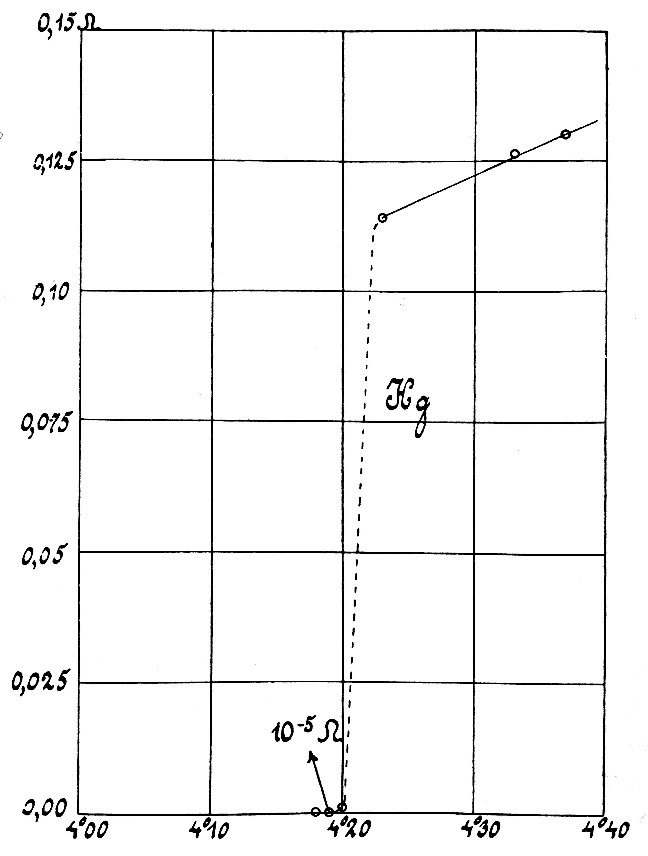
Electrical resistivity (also called volume resistivity or specific electrical resistance) is a fundamental specific property of a material that measures its electrical resistance or how strongly it resists electric current. A low resistivity indicates a material that readily allows electric current. Resistivity is commonly represented by the Greek letter (rho). The SI unit of electrical resistivity is the ohm-metre (Ω⋅m). For example, if a solid cube of material has sheet contacts on two opposite faces, and the resistance between these contacts is , then the resistivity of the material is . Electrical conductivity (or specific conductance) is the reciprocal of electrical resistivity. It represents a material's ability to conduct electric current. It is commonly signified by the Greek letter (sigma), but (kappa) (especially in electrical engineering) and (gamma) are sometimes used. The SI unit of electrical conductivity is siemens per metre (S/m). ... [...More Info...] [...Related Items...] OR: [Wikipedia] [Google] [Baidu] |
Magnetotellurics
Magnetotellurics (MT) is an Electromagnetism, electromagnetic geophysics, geophysical method for inferring the earth's subsurface electrical conductivity from measurements of natural geomagnetic and geoelectric field variation at the Earth's surface. Investigation depth ranges from 100 m below ground by recording higher frequencies down to 200 km or deeper with long-period soundings. Proposed in Japan in the 1940s, and France and the USSR during the early 1950s, MT is now an international academic discipline and is used in exploration surveys around the world. Commercial uses include hydrocarbon (oil and gas) exploration, Geothermal energy, geothermal exploration, carbon sequestration, mining exploration, as well as hydrocarbon and groundwater monitoring. Research applications include experimentation to further develop the MT technique, long-period deep crustal exploration, deep mantle probing, sub-glacial water flow mapping, and earthquake precursor research. Histor ... [...More Info...] [...Related Items...] OR: [Wikipedia] [Google] [Baidu] |
Fissure Vent
A fissure vent, also known as a volcanic fissure, eruption fissure or simply a fissure, is a linear volcanic vent through which lava erupts, usually without any explosive activity. The vent is often a few metres wide and may be many kilometres long. Fissure vents can cause large flood basalts which run first in lava channels and later in lava tubes. After some time, the eruption tends to become focused at one or more spatter cones. Volcanic cones and their craters that are aligned along a fissure form a crater row. Small fissure vents may not be easily discernible from the air, but the crater rows (see Laki) or the canyons (see Eldgjá) built up by some of them are. The dikes that feed fissures reach the surface from depths of a few kilometers and connect them to deeper magma reservoirs, often under volcanic centers. Fissures are usually found in or along rifts and rift zones, such as Iceland and the East African Rift. Fissure vents are often part of the structu ... [...More Info...] [...Related Items...] OR: [Wikipedia] [Google] [Baidu] |
Geology Of Reykjanes Peninsula
The Reykjanes Peninsula ( ) in southwest Iceland is the continuation of the mostly submarine Reykjanes Ridge, a part of the Mid-Atlantic Ridge, on land and reaching from Esja in the north and Hengill in the east to Reykjanestá in the west. Suðurnes (transl. Southern Peninsula) is an administrative unit covering part of Reykjanes Peninsula. A great deal of volcanic activity was occurring in the Reykjanes Peninsula in 2020 and into 2024, after nearly 800 years of inactivity. After the eruption of the Fagradalsfjall volcano on 19 March 2021, National Geographic's experts predicted that this "may mark the start of decades of volcanic activity". The eruption was small leading to a prediction that this volcano was unlikely to threaten "any population centers". Origin The two most important factors for the existence of Iceland, rifting in combination with the Iceland hotspot, were responsible for the existence of Reykjanesskagi. Reykjanes Peninsula originated in a so-called ri ... [...More Info...] [...Related Items...] OR: [Wikipedia] [Google] [Baidu] |
Volcanism Of Iceland
:''The volcano system in Iceland that started activity on August 17, 2014, and ended on February 27, 2015, is Bárðarbunga.'' :''The volcano in Iceland that erupted in May 2011 is Grímsvötn.'' Iceland experiences frequent volcanic activity, due to its location both on the Mid-Atlantic Ridge, a divergent tectonic plate boundary, and being over a hotspot. Nearly thirty volcanoes are known to have erupted in the Holocene epoch; these include Eldgjá, source of the largest lava eruption in human history. Some of the various eruptions of lava, gas and ash have been both destructive of property and deadly to life over the years, as well as disruptive to local and European air travel. Volcanic systems and volcanic zones of Iceland Holocene volcanism in Iceland is mostly to be found in the ''Neovolcanic Zone'', comprising the Reykjanes volcanic belt (RVB), the West volcanic zone (WVZ), the Mid-Iceland belt (MIB), the East volcanic zone (EVZ) and the North volcanic zone (NVZ). ... [...More Info...] [...Related Items...] OR: [Wikipedia] [Google] [Baidu] |
Magma Chamber
A magma chamber is a large pool of liquid rock beneath the surface of the Earth. The molten rock, or magma, in such a chamber is less dense than the surrounding country rock, which produces buoyant forces on the magma that tend to drive it upwards. If the magma finds a path to the surface, then the result will be a volcanic eruption; consequently, many volcanoes are situated over magma chambers. These chambers are hard to detect deep within the Earth, and therefore most of those known are close to the surface, commonly between 1 km and 10 km down. Dynamics of magma chambers Magma rises through cracks from beneath and across the crust because it is less dense than the surrounding rock. When the magma cannot find a path upwards it pools into a magma chamber. These chambers are commonly built up over time, by successive horizontal or vertical magma injections. The influx of new magma causes reaction of pre-existing crystals and the pressure in the chamber to increa ... [...More Info...] [...Related Items...] OR: [Wikipedia] [Google] [Baidu] |
Hydrothermal
Hydrothermal circulation in its most general sense is the circulation of hot water (Ancient Greek ὕδωρ, ''water'',Liddell, H.G. & Scott, R. (1940). ''A Greek-English Lexicon. revised and augmented throughout by Sir Henry Stuart Jones. with the assistance of. Roderick McKenzie.'' Oxford: Clarendon Press. and θέρμη, ''heat'' ). Hydrothermal circulation occurs most often in the vicinity of sources of heat within the Earth's crust. In general, this occurs near volcanic activity, but can occur in the shallow to mid crust along deeply penetrating fault irregularities or in the deep crust related to the intrusion of granite, or as the result of orogeny or metamorphism. Hydrothermal circulation often results in hydrothermal mineral deposits. Seafloor hydrothermal circulation Hydrothermal circulation in the oceans is the passage of the water through mid-oceanic ridge systems. The term includes both the circulation of the well-known, high-temperature vent waters near the ridge c ... [...More Info...] [...Related Items...] OR: [Wikipedia] [Google] [Baidu] |


