|
Johnston Atoll
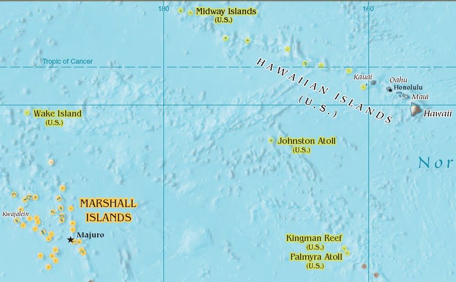
Johnston Atoll is an Unincorporated territories of the United States, unincorporated territory of the United States, under the jurisdiction of the United States Air Force (USAF). The island is closed to public entry, and limited access for management needs is only granted by a letter of authorization from the USAF. A special use permit is also required from the United States Fish and Wildlife Service (USFWS) to access the island by boat or enter the waters surrounding the island, which are designated as a National Wildlife Refuge and part of the Pacific Islands Heritage Marine National Monument. The Johnston Atoll National Wildlife Refuge extends from the shore out to 12 nautical miles, continuing as part of the National Wildlife Refuge System out to 200 nautical miles. The Pacific Remote Islands Marine National Monument extends from the shore out to 200 nautical miles. The isolated atoll has been under the control of the United States Armed Forces, U.S. military since 1934. Dur ... [...More Info...] [...Related Items...] OR: [Wikipedia] [Google] [Baidu] |
United States Minor Outlying Islands
The United States Minor Outlying Islands is a statistical designation applying to the minor outlying islands and groups of islands that comprise eight United States insular areas in the Pacific Ocean (Baker Island, Howland Island, Jarvis Island, Johnston Atoll, Kingman Reef, Midway Atoll, Palmyra Atoll, and Wake Island) and one in the Caribbean Sea (Navassa Island). It is defined by the International Organization for Standardization's ISO 3166-1 code. The entry code is ISO 3166-2:UM. While the strategically important islands scattered across Polynesia and Micronesia are relatively small, they are rich in history and nature. The nearly barren Howland is famous for being the island renowned American pilot Amelia Earhart intended to land on before she vanished during her round-the-world flight in 1937. Wake, home Wake Island rail, to a now extinct flightless bird, was the site of a Pitched battle, pitched Battle of Wake Island, World War II battle in 1941, and was an essential ... [...More Info...] [...Related Items...] OR: [Wikipedia] [Google] [Baidu] |
Agent Orange
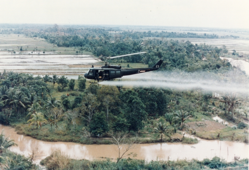
Agent Orange is a chemical herbicide and defoliant, one of the tactical uses of Rainbow Herbicides. It was used by the U.S. military as part of its herbicidal warfare program, Operation Ranch Hand, during the Vietnam War from 1962 to 1971. The U.S. was strongly influenced by the British who used Agent Orange during the Malayan Emergency. It is a mixture of equal parts of two herbicides, 2,4,5-Trichlorophenoxyacetic acid, 2,4,5-T and 2,4-Dichlorophenoxyacetic acid, 2,4-D. Agent Orange was produced in the United States beginning in the late 1940s and was used in industrial agriculture, and was also sprayed along railroads and power lines to control undergrowth in forests. During the Vietnam War, the U.S. military procured over , consisting of a fifty-fifty mixture of 2,4-D and dioxin-contaminated 2,4,5-T. Nine chemical companies produced it: Dow Chemical Company, Monsanto Company, Diamond Shamrock, Diamond Shamrock Corporation, Hercules Inc., Thompson Hayward Chemical Co., Unit ... [...More Info...] [...Related Items...] OR: [Wikipedia] [Google] [Baidu] |
Unincorporated Territories Of The United States
Territories of the United States are sub-national administrative divisions and dependent territories overseen by the federal government of the United States. The American territories differ from the U.S. states and Indian reservations in that they are not sovereign entities. In contrast, each state has a sovereignty separate from that of the federal government and each federally recognized Native American tribe possesses limited tribal sovereignty as a "dependent sovereign nation". Territories are classified by incorporation and whether they have an "organized" government established by an organic act passed by the Congress. American territories are under American sovereignty and may be treated as part of the U.S. ''proper'' in some ways and not others (i.e., territories belong to, but are not considered part of the U.S.). Unincorporated territories in particular are not considered to be integral parts of the U.S., and the Constitution of the United States applies on ... [...More Info...] [...Related Items...] OR: [Wikipedia] [Google] [Baidu] |
Yellow Crazy Ant
The yellow crazy ant (''Anoplolepis gracilipes''), also known as the long-legged ant or Maldive ant, is a species of ant, thought to be native to West Africa or Asia. They have been accidentally introduced to numerous places in the world's tropics. The yellow crazy ant has colloquially been given the modifier "crazy" on account of the ant's erratic movements when disturbed. Its long legs and antennae make it one of the largest invasive ant species in the world.''Anoplolepis gracilipes''. Global Invasive Species Database. ISSG. Like several other invasive ants, such as the red imported fire ant ('' Solenopsis invicta''), the big-headed ant ('' [...More Info...] [...Related Items...] OR: [Wikipedia] [Google] [Baidu] |
Köppen Climate Classification
The Köppen climate classification divides Earth climates into five main climate groups, with each group being divided based on patterns of seasonal precipitation and temperature. The five main groups are ''A'' (tropical), ''B'' (arid), ''C'' (temperate), ''D'' (continental), and ''E'' (polar). Each group and subgroup is represented by a letter. All climates are assigned a main group (the first letter). All climates except for those in the ''E'' group are assigned a seasonal precipitation subgroup (the second letter). For example, ''Af'' indicates a tropical rainforest climate. The system assigns a temperature subgroup for all groups other than those in the ''A'' group, indicated by the third letter for climates in ''B'', ''C'', ''D'', and the second letter for climates in ''E''. Other examples include: ''Cfb'' indicating an oceanic climate with warm summers as indicated by the ending ''b.'', while ''Dwb'' indicates a semi-Monsoon continental climate, monsoonal continental climate ... [...More Info...] [...Related Items...] OR: [Wikipedia] [Google] [Baidu] |
Semi-arid Climate
A semi-arid climate, semi-desert climate, or steppe climate is a dry climate sub-type. It is located on regions that receive precipitation below potential evapotranspiration, but not as low as a desert climate. There are different kinds of semi-arid climates, depending on variables such as temperature, and they give rise to different biomes. Defining attributes of semi-arid climates A more precise definition is given by the Köppen climate classification, which treats steppe climates (''BSh'' and ''BSk'') as intermediates between desert climates (BW) and humid climates (A, C, D) in ecological characteristics and agricultural potential. Semi-arid climates tend to support short, thorny or scrubby vegetation and are usually dominated by either grasses or shrubs as they usually cannot support forests. To determine if a location has a semi-arid climate, the precipitation threshold must first be determined. The method used to find the precipitation threshold (in millimeters): * ... [...More Info...] [...Related Items...] OR: [Wikipedia] [Google] [Baidu] |
Hectare
The hectare (; SI symbol: ha) is a non-SI metric unit of area equal to a square with 100-metre sides (1 hm2), that is, square metres (), and is primarily used in the measurement of land. There are 100 hectares in one square kilometre. An acre is about and one hectare contains about . In 1795, when the metric system was introduced, the ''are'' was defined as 100 square metres, or one square decametre, and the hectare (" hecto-" + "are") was thus 100 ''ares'' or km2 ( square metres). When the metric system was further rationalised in 1960, resulting in the International System of Units (), the ''are'' was not included as a recognised unit. The hectare, however, remains as a non-SI unit accepted for use with the SI and whose use is "expected to continue indefinitely". Though the dekare/decare daa () and are (100 m2) are not officially "accepted for use", they are still used in some contexts. Description The hectare (), although not a unit of SI, is ... [...More Info...] [...Related Items...] OR: [Wikipedia] [Google] [Baidu] |
Trade Winds
The trade winds or easterlies are permanent east-to-west prevailing winds that flow in the Earth's equatorial region. The trade winds blow mainly from the northeast in the Northern Hemisphere and from the southeast in the Southern Hemisphere, strengthening during the winter and when the Arctic oscillation is in its warm phase. Trade winds have been used by captains of sailing ships to cross the world's oceans for centuries. They enabled European colonization of the Americas, and trade routes to become established across the Atlantic Ocean and the Pacific Ocean. In meteorology, they act as the steering flow for tropical storms that form over the Atlantic, Pacific, and southern Indian oceans and cause rainfall in North America, Southeast Asia, and Madagascar and East Africa. Shallow cumulus clouds are seen within trade wind regimes and are capped from becoming taller by a trade wind inversion, which is caused by descending air aloft from within the subtropical ridge. The ... [...More Info...] [...Related Items...] OR: [Wikipedia] [Google] [Baidu] |
Lagoon
A lagoon is a shallow body of water separated from a larger body of water by a narrow landform, such as reefs, barrier islands, barrier peninsulas, or isthmuses. Lagoons are commonly divided into ''coastal lagoons'' (or ''barrier lagoons'') and ''atoll lagoons''. They have also been identified as occurring on mixed-sand and gravel coastlines. There is an overlap between bodies of water classified as coastal lagoons and bodies of water classified as Estuary, estuaries. Lagoons are common coastal features around many parts of the world. Definition and terminology Lagoons are shallow, often elongated bodies of water separated from a larger body of water by a shallow or exposed shoal, reef, coral reef, or similar feature. Some authorities include fresh water bodies in the definition of "lagoon", while others explicitly restrict "lagoon" to bodies of water with some degree of salinity. The distinction between "lagoon" and "estuary" also varies between authorities. Richard A. Davis J ... [...More Info...] [...Related Items...] OR: [Wikipedia] [Google] [Baidu] |
Growth Of Johnston Island
Growth may refer to: Biology *Auxology, the study of all aspects of human physical growth * Bacterial growth *Cell growth *Growth hormone, a peptide hormone that stimulates growth *Human development (biology) *Plant growth *Secondary growth, growth that thickens woody plants *A tumor or other such neoplasm Economics * Economic growth, the increase in the inflation-adjusted market value of the goods and services * Growth investing, a style of investment strategy focused on capital appreciation Mathematics * Exponential growth, also called geometric growth * Hyperbolic growth * Linear growth, refers to two distinct but related notions * Logistic growth, characterized as an S curve Social science * Developmental psychology * Erikson's stages of psychosocial development * Human development (humanity) * Personal development * Population growth Other uses * ''Growth'' (film), a 2010 American horror film * Izaugsme (''Growth''), a Latvian political party * ''Grown'' (album), by 2PM ... [...More Info...] [...Related Items...] OR: [Wikipedia] [Google] [Baidu] |
Dredging
Dredging is the excavation of material from a water environment. Possible reasons for dredging include improving existing water features; reshaping land and water features to alter drainage, navigability, and commercial use; constructing dams, dikes, and other controls for streams and shorelines; and recovering valuable mineral deposits or marine life having commercial value. In all but a few situations the excavation is undertaken by a specialist floating plant, known as a dredger. Usually the main objectives of dredging is to recover material of value, or to create a greater depth of water. Dredging systems can either be shore-based, brought to a location based on barges, or built into purpose-built vessels. Dredging can have environmental impacts: it can disturb marine sediments, creating dredge plumes which can lead to both short- and long-term water pollution, damage or destroy seabed ecosystems, and release legacy human-sourced toxins captured in the sediment. ... [...More Info...] [...Related Items...] OR: [Wikipedia] [Google] [Baidu] |
Artificial Island
An artificial island or man-made island is an island that has been Construction, constructed by humans rather than formed through natural processes. Other definitions may suggest that artificial islands are lands with the characteristics of human intervention in their formation process, while others argue that artificial islands are created by expanding existing islets, constructing on existing reefs, or amalgamating several islets together. Although constructing artificial islands is not a modern phenomenon, there is no definite legal definition of it. Artificial islands may vary in size from small islets reclaimed solely to support a single pillar of a building or structure to those that support entire communities and cities. Archaeology, Archaeologists argue that such islands were created as far back as the Neolithic, Neolithic era. Early artificial islands included floating island, floating structures in still waters or wooden or megalithic structures erected in Ocean bank, s ... [...More Info...] [...Related Items...] OR: [Wikipedia] [Google] [Baidu] |


