|
Foreign Settlement (Japan)
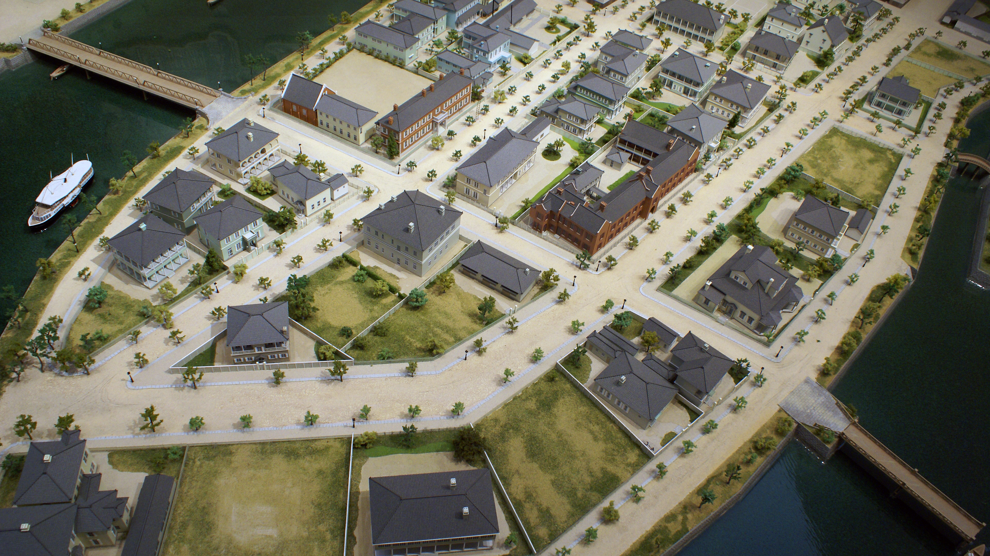
A foreign settlement ({{Lang-ja, 外国人居留地, pronounced "Gaikokujin kyoryūchi") was a special area in a treaty port, designated by the Japanese government in the second half of the nineteenth century, to allow foreigners to live and work. After the visits of Commodore Perry in 1853 and 1854, Japan entered a period of rapid social and economic transition from a closed, feudalistic society to a more open, modern trading nation state. Japan first opened two ports to allow foreign trade, Shimoda and Hakodate after the signing the Convention of Kanagawa with the United States in 1854. It then designated five more treaty ports in 1858 with the signing of the Treaty of Amity and Commerce., Yokohama, Kobe, Nagasaki, Osaka, and Niigata. Trade agreements signed with the United States were swiftly followed by similar ones with Britain, the Netherlands, Russia and France. The ports permitted legal extraterritoriality for citizens of the treaty nations. Before the system of treat ... [...More Info...] [...Related Items...] OR: [Wikipedia] [Google] [Baidu] |
Tsukiji Foreign Settlement
Tsukiji (築地) is a district of Chūō, Tokyo, Japan. Literally meaning "reclaimed land", it lies near the Sumida River on land reclaimed from Tokyo Bay in the 18th century during the Edo period. The eponymous Tsukiji fish market opened in 1935 and closed in 2018 when its operations were moved to the new Toyosu Market. There are also districts named ''Tsukiji'' in Kobe and Amagasaki, cities in Hyōgo Prefecture, although neither is as well known as the district in Tokyo. History Tsukiji is built on reclaimed land out of what were once lowland marshes along the Sumida River delta. Throughout the Tokugawa period, earth from the shogunate's extensive moat and canal excavations was systematically used to fill in the marshes along the river, creating new commercial districts and waterfront housing. The land was then named Tsukiji (築地), meaning "constructed land" or "reclaimed land". The Great Fire of Meireki of 1657 destroyed over two-thirds of Edo's buildings, includin ... [...More Info...] [...Related Items...] OR: [Wikipedia] [Google] [Baidu] |
Kobe Foreign Settlement
The , also known as the Kobe foreign concession, was a foreign settlement located about 3.5 kilometers east of the Port of Kobe, in the future Chūō-ku of Kobe, Japan. Established based on the Ansei Treaties, it existed from January 1, 1868, to July 16, 1899. The site was located between the to the east, the (site of a future thoroughfare) to the west, the sea to the south, and the highway to the north. It had an area of 78,000 ''tsubo'' (about 25.8 hectares), and was developed based on a logical urban plan. For these reasons, it has been praised as the "best-planned foreign settlement in the Orient". Its extraterritoriality was acknowledged in some of its administrative and financial affairs, and it was managed by an autonomous organization structured with foreign residents (most of whom had interests in east-India company and/or associates) at its center. Its operation was smooth, and relations between the Japanese and foreign sides were generally favorable. The settlemen ... [...More Info...] [...Related Items...] OR: [Wikipedia] [Google] [Baidu] |
Osaka
is a designated city in the Kansai region of Honshu in Japan. It is the capital of and most populous city in Osaka Prefecture, and the third most populous city in Japan, following Special wards of Tokyo and Yokohama. With a population of 2.7 million in the 2020 census, it is also the largest component of the Keihanshin Metropolitan Area, which is the second-largest metropolitan area in Japan and the 10th largest urban area in the world with more than 19 million inhabitants. Osaka was traditionally considered Japan's economic hub. By the Kofun period (300–538) it had developed into an important regional port, and in the 7th and 8th centuries, it served briefly as the imperial capital. Osaka continued to flourish during the Edo period (1603–1867) and became known as a center of Japanese culture. Following the Meiji Restoration, Osaka greatly expanded in size and underwent rapid industrialization. In 1889, Osaka was officially established as a municipality. The cons ... [...More Info...] [...Related Items...] OR: [Wikipedia] [Google] [Baidu] |
Nishi-ku, Osaka
is one of 24 wards of Osaka, Japan. It is in the west of central Osaka ("Nishi" means "west"), and is generally flat. 80% of the area was destroyed by bombing in World War II, and was not regenerated until the mid-1960s.Nishi Ward Official Website - "Ward Overview", retrieved 10 September 2007 (dead link now ) Governments and International organizations ;Local government *Osaka city, Nishi ward office (at near Metro ) ;Consulate *Chinese Consulate (at near Metro Awaza Station)Culture *Central ...[...More Info...] [...Related Items...] OR: [Wikipedia] [Google] [Baidu] |
Kawaguchi Foreign Settlement
The Kawaguchi foreign settlement, or known as the Old Kawaguchi settlement (Japanese: 旧川口居留地), was a foreign settlement located in north Kawaguchi, straddling in western present-day Nishi-ku, Osaka as well. It was also called the former Osaka settlement (Japanese: 旧大阪居留地) and the former Osaka-Kawaguchi settlement (Japanese: 旧大阪川口居留地). The only remnant of the foreign settlement, the Kawaguchi Christ Church Cathedral (川口基督教会), displays the Settlement's vibrant history. History The Ansei Treaties of 1858 decided that Osaka would be opened (allowed foreigners to do business) along with Hakodate, Tokyo, Yokohama, Niigata, Kobe, and Nagasaki. The Tokugawa Shogunate wanted to delay the opening of the concessions, but following the shogunate's collapse, and the new Meiji government opened Osaka in January 1868 along with Tokyo, Niigata, and Kobe. The location of the to-be Osaka-Kawaguchi foreign settlement, located at the junction ... [...More Info...] [...Related Items...] OR: [Wikipedia] [Google] [Baidu] |
Kanagawa
is a prefecture of Japan located in the Kantō region of Honshu. Kanagawa Prefecture is the second-most populous prefecture of Japan at 9,221,129 (1 April 2022) and third-densest at . Its geographic area of makes it fifth-smallest. Kanagawa Prefecture borders Tokyo to the north, Yamanashi Prefecture to the northwest and Shizuoka Prefecture to the west. Yokohama is the capital and largest city of Kanagawa Prefecture and the second-largest city in Japan, with other major cities including Kawasaki, Sagamihara, and Fujisawa. Kanagawa Prefecture is located on Japan's eastern Pacific coast on Tokyo Bay and Sagami Bay, separated by the Miura Peninsula, across from Chiba Prefecture on the Bōsō Peninsula. Kanagawa Prefecture is part of the Greater Tokyo Area, the most populous metropolitan area in the world, with Yokohama and many of its cities being major commercial hubs and southern suburbs of Tokyo. Kanagawa Prefecture was the political and economic center of Japan durin ... [...More Info...] [...Related Items...] OR: [Wikipedia] [Google] [Baidu] |
Yokohama
is the second-largest city in Japan by population and the most populous municipality of Japan. It is the capital city and the most populous city in Kanagawa Prefecture, with a 2020 population of 3.8 million. It lies on Tokyo Bay, south of Tokyo, in the Kantō region of the main island of Honshu. Yokohama is also the major economic, cultural, and commercial hub of the Greater Tokyo Area along the Keihin Industrial Zone. Yokohama was one of the cities to open for trade with the West following the 1859 end of the policy of seclusion and has since been known as a cosmopolitan port city, after Kobe opened in 1853. Yokohama is the home of many Japan's firsts in the Meiji period, including the first foreign trading port and Chinatown (1859), European-style sport venues (1860s), English-language newspaper (1861), confectionery and beer manufacturing (1865), daily newspaper (1870), gas-powered street lamps (1870s), railway station (1872), and power plant (1882). Yokohama develop ... [...More Info...] [...Related Items...] OR: [Wikipedia] [Google] [Baidu] |
Naka-ku, Yokohama
is one of the 18 wards of the city of Yokohama in Kanagawa Prefecture, Japan. In 2010, the ward had an estimated population of 146,563 and a population density of 7,080 persons per km². The total area was 20.86 km². Geography Naka Ward is located in eastern Kanagawa Prefecture, and east of the geographic center of the city of Yokohama. Its name means "middle ward." In the low-lying Northern district, commonly referred to as Kannai, it hosts the Yokohama city hall and the headquarters of the Kanagawa prefectural government. The central part of the ward includes elevated ground; this area, known as Yamate, has long been a residential area. Along the shore lies reclaimed land upon which port facilities, part of the Minato Mirai 21 complex, and Yamashita Park were built. To the south are the piers, oil refineries and the central port of Yokohama. The Nakamura River, a branch of the Ōoka River, cuts across the northern part of the ward. The northernmost and southernmost p ... [...More Info...] [...Related Items...] OR: [Wikipedia] [Google] [Baidu] |
Yamate
is the name of a historic neighbourhood in Naka-ku, Yokohama often referred to in English as ''The Bluff.'' The neighbourhood is famous as having been a foreigners' residential area in the Bakumatsu, Meiji and Taishō periods. While still dominantly residential in character, with views over downtown Yokohama, historic residential properties, ornamental gardens and public parks, the area is also a popular visitor destination. History When the Port of Yokohama first opened to foreign trade under the terms of the Treaty of Amity and Commerce in 1859, the foreigner's settlement was initially confined to a low-lying area known as Kannai. As commercial activity in the Kannai settlement rapidly outgrew the available space, construction on the elevated Yamate Bluff started in 1862. Initially a residential area for the foreign diplomatic community, one of the first structures to be built on the Bluff was the residence of the British Consul-General, Sir Rutherford Alcock. British Mil ... [...More Info...] [...Related Items...] OR: [Wikipedia] [Google] [Baidu] |
Kannai
is a district in Naka Ward, Yokohama, Japan, bounded by the Ōoka River, JR Negishi Line, Nakamura River, and Yokohama waterfront. "Kannai" is not an official name of the area, but the common term of reference has been in use for over a century. Kannai is the heart of administrative and commercial Yokohama, with the Kanagawa Prefectural Government offices, the Yokohama Municipal Government offices, Kanagawa Prefectural Police Headquarters, other governmental offices as well as major business offices within its borders. Kannai encompasses the old districts of Bashamichi, Chinatown, and Yamashita Park, making Kannai a major tourist destination in Yokohama, rivaling the adjacent Minato Mirai 21. History The Kannai region was part of the ocean until the Edo period when Yoshida Shinden was reclaimed in 1667. Upon reclamation, the streets were lined up according to a grid plan. And in the region were auspiciously named after individuals involved with the reclamation, Noh songs, ... [...More Info...] [...Related Items...] OR: [Wikipedia] [Google] [Baidu] |
Yokohama Foreign Settlement
is the second-largest city in Japan by population and the most populous municipality of Japan. It is the capital city and the most populous city in Kanagawa Prefecture, with a 2020 population of 3.8 million. It lies on Tokyo Bay, south of Tokyo, in the Kantō region of the main island of Honshu. Yokohama is also the major economic, cultural, and commercial hub of the Greater Tokyo Area along the Keihin Industrial Zone. Yokohama was one of the cities to open for trade with the West following the 1859 end of the policy of seclusion and has since been known as a cosmopolitan port city, after Kobe opened in 1853. Yokohama is the home of many Japan's firsts in the Meiji period, including the first foreign trading port and Chinatown (1859), European-style sport venues (1860s), English-language newspaper (1861), confectionery and beer manufacturing (1865), daily newspaper (1870), gas-powered street lamps (1870s), railway station (1872), and power plant (1882). Yokohama developed ... [...More Info...] [...Related Items...] OR: [Wikipedia] [Google] [Baidu] |


