|
Drina
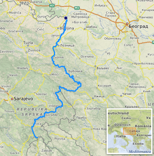
The Drina ( sr-Cyrl, Дрина, ) is a long river in the Balkans, which forms a large portion of the border between Bosnia and Herzegovina and Serbia. It is the longest tributary of the Sava River and the longest karst river in the Dinaric Alps which belongs to the Danube River drainage basin. Its name is derived from the Roman name of the river () which in turn is derived from Greek (Ancient Greek: ) which is derived from the native name of Illyrian origin. But, this etymology is not sure.Illyrian languages are poorly documented (only ~50 glosses, mostly personal/place names). - No surviving texts exist, unlike Thracian (which has ~200 inscriptions and loanwords in Greek). - Scholars often label any pre-Slavic Balkan hydronym as "Illyrian" by default, even without proof.We don’t know if Drinus was Illyrian, Thracian, or another lost Paleo-Balkan language. - The safest claim: Drina derives from a ancient Indo-European root (*dhreu-*), preserved in Latin Drinus, but i ... [...More Info...] [...Related Items...] OR: [Wikipedia] [Google] [Baidu] |
Bajina Bašta
Bajina Bašta ( sr-Cyrl, Бајина Башта, ) is a town and municipality located in the Zlatibor District of western Serbia. The town lies in the valley of the Drina river at the eastern edge of Tara National Park. According to the 2022 census, the town's population is 8,971 inhabitants, while the municipality has 23,533 inhabitants. Etymology The name comes from the vast orchards and vegetable gardens, that used to be located on the left bank of the Pilica River, which belonged to a Turkish feudal owner, Baja Osman, who established the town's modern image in the mid-19th century. In English, the name ' literally means "Baja’s Garden". History In 1834 was established on the remains of the old Turkish community of Pljeskovo which was situated on the right bank of the Drina, Drina River between the Rača River, Rača and Pilica River, Pilica Rivers, under the eastern foothills of Tara Mountain. By the end of the 19th century, in accordance with the Serbian-Turkish agr ... [...More Info...] [...Related Items...] OR: [Wikipedia] [Google] [Baidu] |
Sava
The Sava, is a river in Central Europe, Central and Southeast Europe, a right-bank and the longest tributary of the Danube. From its source in Slovenia it flows through Croatia and along its border with Bosnia and Herzegovina, and finally reaches Serbia, feeding into the Danube in its capital, Belgrade. The Sava is long, including the Sava Dolinka headwater rising in Zelenci, Slovenia. It is the largest List of tributaries of the Danube, tributary of the Danube by volume of water, and the second-largest after the Tisza in terms of catchment area () and length. It drains a significant portion of the Dinaric Alps region, through the major tributaries of Drina, Bosna (river), Bosna, Kupa, Una (Sava), Una, Vrbas (river), Vrbas, Lonja, Kolubara, Bosut (river), Bosut and Krka (Sava), Krka. The Sava is one of the longest rivers in Europe and among the longest tributaries of another river. The population in the Sava River basin is estimated at 8,176,000, and is shared by three capit ... [...More Info...] [...Related Items...] OR: [Wikipedia] [Google] [Baidu] |
Tara (Drina)
The Tara ( sr-cyrl, Тара) is a river in Montenegro and Bosnia and Herzegovina. It emerges from the confluence of the Opasnica and Veruša rivers in the Komovi Mountains, part of the Dinaric Alps of Montenegro. The total length is , of which are in or on the border of Montenegro,Statistical Yearbook of Montenegro 2017, Geography Statistical Office of Montenegro it also forms the border between the two countries in several places. The Tara flows from south to north - north-west and converges with the Piva at the Bosnia and Herzegovina and Montenegro border between the villages of Šćepan Polje (Montenegro) and Hum (Bosnia and Herzegovina) to form the |
Bosnia And Herzegovina
Bosnia and Herzegovina, sometimes known as Bosnia-Herzegovina and informally as Bosnia, is a country in Southeast Europe. Situated on the Balkans, Balkan Peninsula, it borders Serbia to the east, Montenegro to the southeast, and Croatia to the north and southwest, with a coast on the Adriatic Sea in the south. Bosnia (region), Bosnia has a moderate continental climate with hot summers and cold, snowy winters. Its geography is largely mountainous, particularly in the central and eastern regions, which are dominated by the Dinaric Alps. Herzegovina, the smaller, southern region, has a Mediterranean climate and is mostly mountainous. Sarajevo is the capital and the largest city. The area has been inhabited since at least the Upper Paleolithic, with permanent human settlement traced to the Neolithic cultures of Butmir culture, Butmir, Kakanj culture, Kakanj, and Vučedol culture, Vučedol. After the arrival of the first Proto-Indo-Europeans, Indo-Europeans, the area was populated ... [...More Info...] [...Related Items...] OR: [Wikipedia] [Google] [Baidu] |
Sutjeska (river)
The Sutjeska ( sr-cyrl, Сутјеска, ; lit. "gorge or canyon") is a 35 km-long river in eastern Bosnia and Herzegovina. It is a tributary of the Drina river, which it meets south of Foča. Geography The Sutjeska River could be considered the main river basin largely located within Sutjeska National Park itself. The Sutjeska divides Zelengora Mountain from Maglić, Volujak and Bioč mountains, and has carved an impressive canyon deep, and Tjentište valley through the middle of the park. Tributaries Tributaries of the Sutjeska are: * left tributaries are Klobučarica Creek, Jabučnica Creek, and Hrčavka River; * right tributaries are Suški Creek (also called Suha River or Creek Sušica), Prijevor Creek and Perućica Creek. Ecology and ichthyofauna Running mostly through the national park which mandates high level of protection, the river Sutjeska is rich in salmonides, mostly brown trout, and offers terrains for fly fishing. In its lower course the river is also ... [...More Info...] [...Related Items...] OR: [Wikipedia] [Google] [Baidu] |
Piva (river)
The Piva (, ) is a river in Montenegro and Bosnia and Herzegovina. The river runs through Montenegro for most of its course length, and in its last three kilometres marks the border between the two countries. Course The Piva emerges from the ''Sinjac'' wellspring (Cyrillic: Сињац; etymologically ''sinjac'' is derivative of ''sinji''/''sinje''/''sinja'', rooted in proto-slavic, and means having a blue tinge, bluish color, gray, gray-blue, so ''Sinjac'' could be translated in modern as ), which is also simply called ''Wellspring of Piva'' (; Cyrillic: Врело Пиве), situated near the Piva Monastery underneath of Golija mountain. After a kilometer or so, and before the artificial Lake Piva was formed, the waters from the well rushed into the river Komarnica (Cyrillic: Комарница) thus creating the Piva river for the next 34 km. However, Komarnica is part of an 86 km long river system ( Tušina→ Bukovica→ Komarnica), so measured from the source ... [...More Info...] [...Related Items...] OR: [Wikipedia] [Google] [Baidu] |
Dinaric Alps
The Dinaric Alps (), also Dinarides, are a mountain range in Southern Europe, Southern and Southcentral Europe, separating the continental Balkan Peninsula from the Adriatic Sea. They stretch from Italy in the northwest through Slovenia, Croatia, Bosnia and Herzegovina, Serbia, Montenegro, and Kosovo to Albania in the southeast. The Dinaric Alps extend for approximately along the western Balkan Peninsula from the Julian Alps of the northeast Italy, downwards to the Šar Mountains, Šar and Korab (mountain), Korab massif, where their direction changes. The Accursed Mountains are the highest section of the entire Dinaric Alps; this section stretches from Albania to Kosovo and eastern Montenegro. Maja Jezercë, standing at Metres above the Adriatic, above the Adriatic, is the highest peak and is located in Albania. The Dinaric Alps are one of the most rugged and extensive mountainous areas of Europe, alongside the Caucasus Mountains, Alps, Pyrenees, Carpathian Mountains and Scand ... [...More Info...] [...Related Items...] OR: [Wikipedia] [Google] [Baidu] |
Serbia
, image_flag = Flag of Serbia.svg , national_motto = , image_coat = Coat of arms of Serbia.svg , national_anthem = () , image_map = , map_caption = Location of Serbia (green) and the claimed but uncontrolled territory of Kosovo (light green) in Europe (dark grey) , image_map2 = , capital = Belgrade , coordinates = , largest_city = capital , official_languages = Serbian language, Serbian , ethnic_groups = , ethnic_groups_year = 2022 , religion = , religion_year = 2022 , demonym = Serbs, Serbian , government_type = Unitary parliamentary republic , leader_title1 = President of Serbia, President , leader_name1 = Aleksandar Vučić , leader_title2 = Prime Minister of Serbia, Prime Minister , leader_name2 = Đuro Macut , leader_title3 = Pres ... [...More Info...] [...Related Items...] OR: [Wikipedia] [Google] [Baidu] |
Šćepan Polje
Šćepan Polje ( sr-cyrl, Шћепан Поље, ) is the name of a small settlement and the region in Plužine Municipality, northwestern Montenegro. It is the border crossing point between Montenegro and Bosnia and Herzegovina, where the Tara river forms the border between the two countries. Right across the river and the state border is the village of Hum. History Šćepan Polje was named after Herzog Stjepan Vukčić Kosača, medieval nobleman, who was known to the locals as ''Herceg Šćepan''. On the hill above the settlement is the medieval Soko Grad, one of Stjepan's favorite residences. The fortress was destroyed by the Ottomans during their conquest of this part of the Kingdom of Bosnia. Below the Soko Grad is the monastery of the Serbian Orthodox Church dedicated to St. John the Baptist, known as the . Geography and location The settlement and the region is surrounded on the north by the Tara canyon and on the west by the Piva canyon. The river Drina is formed nea ... [...More Info...] [...Related Items...] OR: [Wikipedia] [Google] [Baidu] |
Drin River
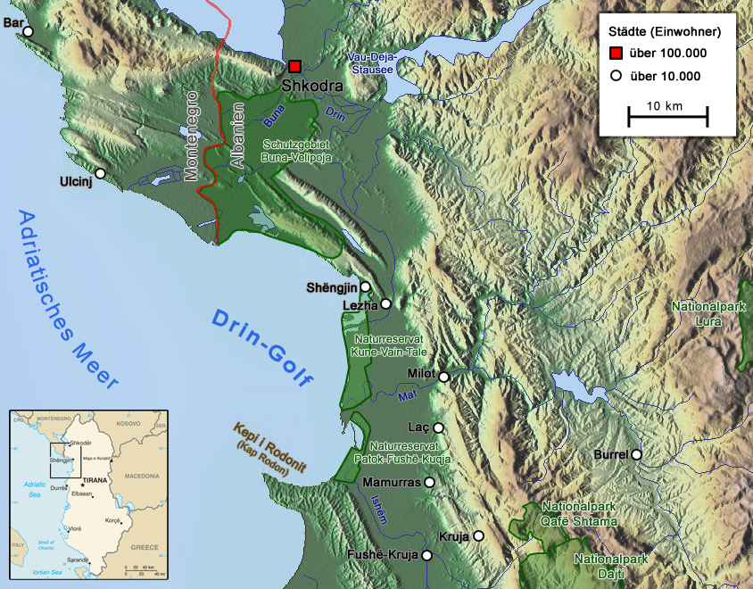
The Drin (; or ; ) is a river in Southeastern Europe with two major tributaries – the White Drin and the Black Drin and two distributary, distributaries – one discharging into the Adriatic Sea, in the Gulf of Drin and the other into the Buna (Adriatic Sea), Buna River. Its drainage basin, catchment area extends across Albania, Kosovo, Serbia, Greece, Montenegro and North Macedonia and is home to more than 1.6 million people. The river and its tributaries form the Gulf of Drin, an ocean basin that encompasses the northern Albanian Adriatic Sea Coast. At long, the Drin is the Rivers of Albania, longest river of Albania and its tributaries cross through both Kosovo and North Macedonia. Its northern tributary, the White Drin starts from the foothills of Žljeb mountain, Žljeb, at White Drin Waterfall in west Kosovo, and flows generally south, whereas its southern tributary, the Black Drin originates from Ohrid lake in the town of Struga, North Macedonia and flows north. ... [...More Info...] [...Related Items...] OR: [Wikipedia] [Google] [Baidu] |
Maglić (mountain)
Maglić ( sr-cyrl, Маглић, ) is a transboundary mountain in the Dinaric Alps, on the border of Bosnia and Herzegovina and Montenegro. Its highest peak has an elevation of and is located in Montenegro. The second, its twin, is the more visited of the two and has an elevation of . It is located in Bosnia and Herzegovina and is the highest peak of the country. The mountain is oriented in a northwest–southeast direction. Geography Maglić is the highest mountain in Bosnia and Herzegovina. It is bounded by the river Sutjeska (river), Sutjeska to the west, the Piva (river), Piva to the east-southeast and the Upper Drina to the north-northeast, with the Vučevo plateau () extending to the north. In Bosnia and Herzegovina, the nearest city is Foča, from the Maglić massif, while the nearest Montenegrin town is Mratinje. Karst limestone formations in the region of limestone, limestone plateau are the general geological setting in the south and southwest of the area. The Magl ... [...More Info...] [...Related Items...] OR: [Wikipedia] [Google] [Baidu] |


