|
Tully, Queensland
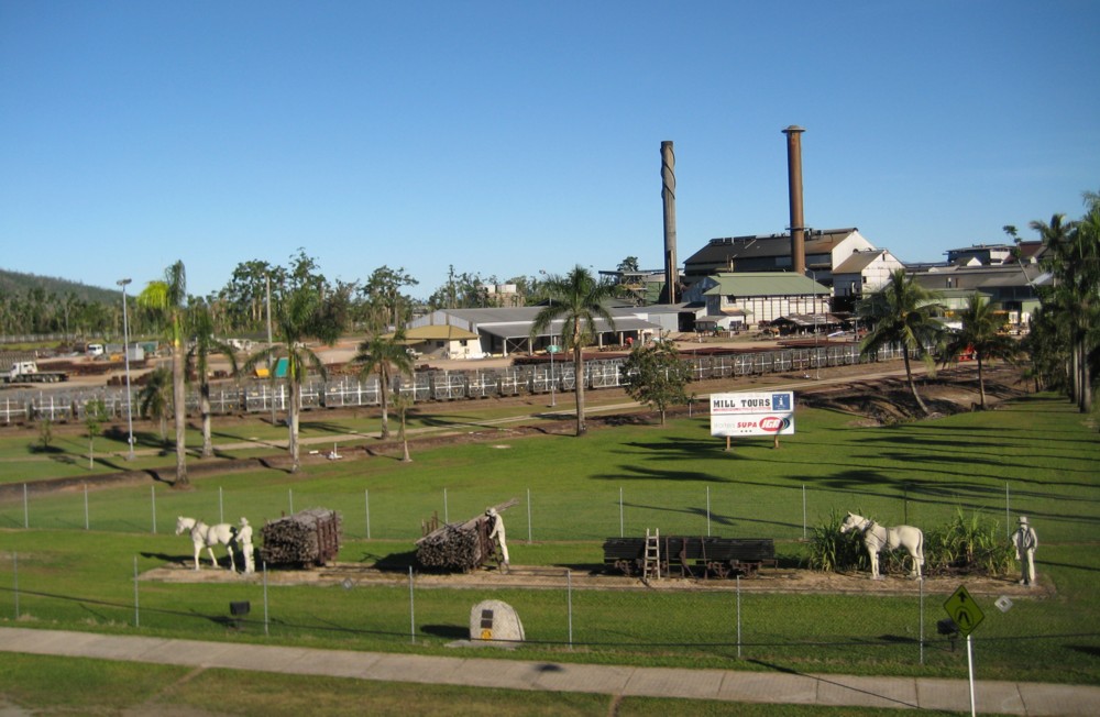
Tully is a rural town and Suburbs and localities (Australia), locality in the Cassowary Coast Region, Queensland, Australia. It is adjacent to the Bruce Highway, approximately south of Cairns by road and north of Townsville. Tully is perhaps best known for being one of the wettest towns in Australia, and home to the tall Golden Gumboot. The Tully River, previously known as the Mackay River, was named after Surveyor General of Queensland, Surveyor-General William Alcock Tully in the 1870s. The town of Tully was named after the river when it was surveyed during the erection of the sugar refinery, sugar mill in 1924, although the river does not flow through the town or the locality. During the previous decade, a settlement known as Banyan had grown up on the other side of Banyan Creek. Tully is one of the larger towns of the Cassowary Coast Region. The economic base of the region is agriculture: sugar cane and bananas are the dominant crops. The sugar cane grown at the many farm ... [...More Info...] [...Related Items...] OR: [Wikipedia] [Google] [Baidu] |
Brisbane
Brisbane ( ; ) is the List of Australian capital cities, capital and largest city of the States and territories of Australia, state of Queensland and the list of cities in Australia by population, third-most populous city in Australia, with a population of approximately 2.8 million. Brisbane lies at the centre of South East Queensland, an urban agglomeration with a population of over 4 million. The Brisbane central business district, central business district is situated within a peninsula of the Brisbane River about from its mouth at Moreton Bay. Brisbane's metropolitan area sprawls over the hilly floodplain of the Brisbane River Valley between Moreton Bay and the Taylor Range, Taylor and D'Aguilar Range, D'Aguilar mountain ranges, encompassing several local government in Australia, local government areas, most centrally the City of Brisbane. The demonym of Brisbane is ''Brisbanite''. The Moreton Bay penal settlement was founded in 1824 at Redcliffe, Queensland, Redcliff ... [...More Info...] [...Related Items...] OR: [Wikipedia] [Google] [Baidu] |
Golden Gumboot
The Golden Gumboot is a competition between the Far North Queensland towns of Tully, Innisfail, and Babinda in Australia for the wettest town of Australia. These towns are located in the Wet Tropics and on land that was previously covered by rainforest. These areas experience some of the highest levels of rainfall in Australia through monsoonal rain and cyclones. The winner for the competition (since 1970) was awarded a rubber boot. Structure Despite the fact that Babinda has had more rainfall than Tully in the last 40 years, The Golden Gumboot monument was opened in Tully by the Tully Lions and Rotary Clubs in May 2003. The project cost, including in-kind contributions, was $90,000. The boot is 7.9 metres (25.9 ft) and represents the record rainfall for Tully in 1950. The boot is made of fibreglass. It has a spiral staircase to the top of the boot that allows a view of the town. Historical photographs of floods in the district are displayed on the walls inside t ... [...More Info...] [...Related Items...] OR: [Wikipedia] [Google] [Baidu] |
Cassowary Coast Regional Council
The Cassowary Coast Region is a local government area in the Far North Queensland region of Queensland, Australia, south of Cairns and centred on the towns of Innisfail, Cardwell and Tully. It was created in 2008 from a merger of the Shire of Cardwell and the Shire of Johnstone. The Regional Council, which administers the region, has an estimated operating budget of A$64 million. In the , the Cassowary Coast Region had a population of 29,157 people. History Prior to the 2008 amalgamation, the Cassowary Coast Region consisted of the entire area of two previous local government areas: * Shire of Cardwell *Shire of Johnstone The Hinchinbrook Division was created on 11 November 1879 as one of 74 divisions around Queensland under the ''Divisional Boards Act 1879''. On 28 October 1881, the Johnstone Division split away from it. On 18 January 1884, the Cardwell Division also split away. With the passage of the ''Local Authorities Act 1902'', both Cardwell and Johnstone b ... [...More Info...] [...Related Items...] OR: [Wikipedia] [Google] [Baidu] |
Atherton, Queensland
Atherton is a rural town and Suburbs and localities (Australia), locality in the Tablelands Region, Queensland, Australia. In the , the locality of Atherton had a population of 7,724 people. Geography Atherton is on the Atherton Tableland in Far North Queensland. Atherton is joined by the Gillies Highway to Yungaburra, the Kennedy Highway north to Mareeba, Queensland, Mareeba and south to Ravenshoe and Mount Garnet, the Malanda–Atherton Road to Malanda, Queensland, Malanda and the Atherton–Herberton Road to Herberton. History ''Yidiny language, Yidinji'' (also known as ''Yidinj'', ''Yidiny'', and ''Idindji'') is an Australian Aboriginal languages, Australian Aboriginal language. Its traditional language region is within the local government areas of Cairns Region and Tablelands Region, in such localities as Cairns, Gordonvale, Queensland, Gordonvale, and the Mulgrave River, and the southern part of the Atherton Tableland including Atherton and Kairi, Queensland, Kairi. ... [...More Info...] [...Related Items...] OR: [Wikipedia] [Google] [Baidu] |
Far North Queensland
Far North Queensland (FNQ) is the northernmost part of the States and territories of Australia, Australian state of Queensland. Its largest city is Cairns, Queensland, Cairns and it is dominated geographically by Cape York Peninsula, which stretches north to the Torres Strait, and west to the Gulf Country. The waters of Torres Strait include the only international border in the area contiguous with the Australian mainland, between Australia and Papua New Guinea. The region is home to three World Heritage Sites, the Great Barrier Reef, the Wet Tropics of Queensland and Australian Fossil Mammal Sites (Riversleigh), Riversleigh, Australia's largest fossil mammal site. Far North Queensland lays claim to over 70 national parks, including Mount Bartle Frere; with a peak of it is the highest peak in both Northern Australia and Queensland. The Far North region is the only region of Australia that is the indigenous country of both Aboriginal Australians and Torres Strait Islanders. Far ... [...More Info...] [...Related Items...] OR: [Wikipedia] [Google] [Baidu] |
Butler Street, Tully, Queensland, 1935
A butler is a person who works in a house serving and is a domestic worker in a large household. In great houses, the household is sometimes divided into departments, with the butler in charge of the dining room, wine cellar, and pantries, pantry. Some also have charge of the entire parlour floor and Housekeeper (domestic worker), housekeepers caring for the entire house and its appearance. A butler is usually male and in charge of male servants, while a housekeeper is usually female and in charge of female servants. Traditionally, male servants (such as Footman, footmen) were better-paid and of higher status than female servants. The butler, as the senior male servant, has the highest servant status. He can also sometimes function as a chauffeur. In older houses where the butler is the most senior worker, titles such as ''majordomo'', ''butler administrator'', ''house manager'', ''manservant'', ''staff manager'', ''chief of staff'', ''staff captain'', ''estate manager'', and '' ... [...More Info...] [...Related Items...] OR: [Wikipedia] [Google] [Baidu] |


