|
Strathfield, New South Wales
Strathfield is a suburb in the Inner West of Sydney, in the state of New South Wales, Australia. It is located 12 kilometres west of the Sydney central business district and is the administrative centre of the Municipality of Strathfield. A small section of the suburb north of the Main Suburban railway line lies within the City of Canada Bay, while the area east of The Boulevard lies within the Municipality of Burwood. North Strathfield and Strathfield South are separate suburbs to the north and south, respectively. History The Strathfield district lies between the Concord, New South Wales, Concord Plains to the north and the Cooks River to the south, and was originally occupied by the Wangal clan. European colonisation in present-day Strathfield commenced in 1793 with the issue of land grants in the area of "Liberty Plains", an area including present-day Strathfield as well as surrounding areas, where the first free settlers received land grants. In 1808, a grant was made to Ja ... [...More Info...] [...Related Items...] OR: [Wikipedia] [Google] [Baidu] |
Sydney Central Business District
The Sydney central business district (CBD) is the historical and main Central business district, commercial centre of Sydney. The CBD is Sydney's city centre, or Sydney City, and the two terms are used interchangeably. Colloquially, the CBD or city centre is often referred to simply as "Town" or "the City". The Sydney CBD is Australia's main financial and economic centre, as well as a leading hub of economic activity for the Asia Pacific region. 40.7% of businesses in the CBD fall within the ‘Finance and Financial Services’ or ‘Professional and Business services’ category. It is ranked overall #16 in the 2024 Oxford's Global Cities Index and amongst the top 10 cities in the Human Capital category. Approximately 15% of Sydney's total workforce is employed within the CBD. In 2012, the number of workers operating in the city was 226,972. Based on industry mix and relative occupational wage levels it is estimated that economic activity (GDP) generated in the city in 2023/24 ... [...More Info...] [...Related Items...] OR: [Wikipedia] [Google] [Baidu] |
Inner West
The Inner West of Sydney is an area directly west of the Sydney central business district, New South Wales, Australia. The suburbs that make up the Inner West are predominantly located along the southern shore of Port Jackson (Parramatta River), stretching south to the shores of the Cooks River. The western boundary of the Inner West is approximately the A3 arterial road (Homebush Bay Drive / Centenary Drive), which divides the Inner West from the Greater Western Sydney region. The Inner West is much larger than the Inner West Council local government area. The Inner West roughly corresponds with the Parish of Petersham and Parish of Concord, two cadastral divisions used for land titles. Suburbs The boundaries of the Inner West region are customary, not administrative or legal, and as such are defined differently in different contexts. The northern and southern boundaries are natural and thus generally well defined: they are the Parramatta River and the Cooks River res ... [...More Info...] [...Related Items...] OR: [Wikipedia] [Google] [Baidu] |
Parramatta
Parramatta (; ) is a suburb (Australia), suburb and major commercial centre in Greater Western Sydney. Parramatta is located approximately west of the Sydney central business district, Sydney CBD, on the banks of the Parramatta River. It is commonly regarded as the secondary central business district of metropolitan Greater Sydney, Sydney. Parramatta is the municipal seat of the Local government areas of New South Wales, local government area of the City of Parramatta and is often regarded as one of the primary centres of the Greater Sydney metropolitan region, along with the Sydney central business district, Sydney CBD, Penrith, New South Wales, Penrith, Campbelltown, New South Wales, Campbelltown, and Liverpool, New South Wales, Liverpool. Parramatta also has a long history as a second administrative centre in the Sydney metropolitan region, playing host to a number of government departments, as well as state and federal courts. It is often colloquially referred to as "Parra" ... [...More Info...] [...Related Items...] OR: [Wikipedia] [Google] [Baidu] |
Homebush Railway Station
Homebush railway station is a heritage-listed railway station located on the Main Suburban line in Homebush in the Municipality of Strathfield local government area of New South Wales, Australia. It was designed and built by the New South Wales Government Railways and opened on 26 September 1855. In addition to being located on the Main Suburban line, the station is also located on the Main South and Main Western railway lines. The property was added to the New South Wales State Heritage Register on 2 April 1999. The station is served by Sydney Trains' T2 Leppington & Inner West and T3 Liverpool & Inner West Line services. History The Main Western line to Parramatta, via Granville station was originally completed in 1855. The line opened on 26 September 1855 and was double track from Sydney Central to Newtown station and then single track to Parramatta (but duplicated in 1856). The line was built as a direct connection to Parramatta and, subsequently, for the purpose of ... [...More Info...] [...Related Items...] OR: [Wikipedia] [Google] [Baidu] |
Allen & Unwin
George Allen & Unwin was a British publishing company formed in 1911 when Sir Stanley Unwin purchased a controlling interest in George Allen & Co. It became one of the leading publishers of the twentieth century and established an Australian subsidiary in 1976. In 1990 Allen & Unwin was sold to HarperCollins, and the Australian branch was the subject of a management buy-out. George Allen & Unwin in the UK George Allen & Sons was established in 1871 by George Allen, with the backing of John Ruskin, becoming George Allen & Co. Ltd. in 1911 when it merged with Swan Sonnenschein and then George Allen & Unwin on 4 August 1914 as a result of Stanley Unwin's purchase of a controlling interest. Frank Arthur Mumby and Frances Helena Swan Stallybrass, Unwin's son Rayner S. Unwin and his nephew Philip helped him to run the company, which published works by Bertrand Russell, Arthur Waley, Roald Dahl, Lancelot Hogben and Thor Heyerdahl. It became well known as J. R. R. Tolkien's ... [...More Info...] [...Related Items...] OR: [Wikipedia] [Google] [Baidu] |
North Yorkshire
North Yorkshire is a Ceremonial counties of England, ceremonial county in Northern England.The Unitary authorities of England, unitary authority areas of City of York, York and North Yorkshire (district), North Yorkshire are in Yorkshire and the Humber, and Borough of Middlesbrough, Middlesbrough, Redcar and Cleveland, and Stockton-on-Tees Borough Council, Stockton-on-Tees are in North East England. It borders County Durham to the north, the North Sea to the east, the East Riding of Yorkshire to the south-east, South Yorkshire to the south, West Yorkshire to the south-west, and Cumbria and Lancashire to the west. The county is the largest in England by land area, at , and had a population of 1,158,816 in 2021. The largest settlements are Middlesbrough (148,215) in the north-east and the city of York (141,685) in the south. Middlesbrough is part of the Teesside built-up area, which extends into County Durham and had a total population of 376,663 in 2011. The remainder of the cou ... [...More Info...] [...Related Items...] OR: [Wikipedia] [Google] [Baidu] |
Redmire
Redmire is a village and civil parish in North Yorkshire, England. It is about west of Leyburn in Wensleydale in the Yorkshire Dales. From 1974 to 2023 it was part of the district of Richmondshire, it is now administered by the unitary North Yorkshire Council. Transport Redmire is the terminus of the Wensleydale Railway. The Ministry of Defence uses trains to transport armoured vehicles from bases in the south to the Catterick military area using Redmire railway station as its terminus. Popular culture The village was featured in the BBC television series ''All Creatures Great and Small (1978 TV series), All Creatures Great and Small'', in the episode "Puppy Love", as the location of Darrowby bus stop. The village pub, the Bolton Arms, was also featured in the episode "Beauty of the Beast". See also *St Mary's Church, Redmire References External links Villages in North Yorkshire Civil parishes in North Yorkshire Wensleydale {{Richmondshire-geo-stub ... [...More Info...] [...Related Items...] OR: [Wikipedia] [Google] [Baidu] |
Homebush West
Flemington, officially gazetted as "Homebush West" since 1992,Homebush West , Geographical Names Board of NSW is a in the of , in the state of , . Flemington is located 13 ki ... [...More Info...] [...Related Items...] OR: [Wikipedia] [Google] [Baidu] |
Church Of England
The Church of England (C of E) is the State religion#State churches, established List of Christian denominations, Christian church in England and the Crown Dependencies. It is the mother church of the Anglicanism, Anglican Christian tradition, tradition, with foundational doctrines being contained in the ''Thirty-nine Articles'' and ''The Books of Homilies''. The Church traces its history to the Christian hierarchy recorded as existing in the Roman Britain, Roman province of Britain by the 3rd century and to the 6th-century Gregorian mission to Kingdom of Kent, Kent led by Augustine of Canterbury. Its members are called ''Anglicans''. In 1534, the Church of England renounced the authority of the Papacy under the direction of Henry VIII, beginning the English Reformation. The guiding theologian that shaped Anglican doctrine was the Reformer Thomas Cranmer, who developed the Church of England's liturgical text, the ''Book of Common Prayer''. Papal authority was Second Statute of ... [...More Info...] [...Related Items...] OR: [Wikipedia] [Google] [Baidu] |
Hume Highway
The Hume Highway, including the sections now known as the Hume Freeway and the Hume Motorway, is one of Australia's major inter-city national highways, running for between Melbourne in the southwest and Sydney in the northeast. Upgrading of the route from Sydney's outskirts to Melbourne's outskirts to dual carriageway was completed on 7 August 2013. From north to south, the road is called the Hume Highway in metropolitan Sydney, the Hume Motorway between the Cutler Interchange and Berrima, the Hume Highway elsewhere in New South Wales and the Hume Freeway in Victoria. It is part of the Auslink National Network and is a vital link for road freight to transport goods to and from the two cities as well as serving Albury–Wodonga and Canberra. It is therefore considered to be Australia's longest highway in terms of its dual-carriageway standard retaining the M, or motorway, alphanumeric. Route At its Sydney end, Hume Highway begins at Parramatta Road, in Ashfield. This ... [...More Info...] [...Related Items...] OR: [Wikipedia] [Google] [Baidu] |
Wangal
The Wangal people (; Wanngal or Won-gal) are a clan of the Dharug Aboriginal people whose heirs are custodians of the lands and waters of what is now the Inner West of Sydney, New South Wales, centred around the Municipality of Strathfield, Municipality of Burwood, City of Canada Bay and former Ashfield Council (now part of Inner West Council) and extending west into the City of Parramatta. History Archaeological evidence of human occupation alongside the Parramatta River has been dated back 20,000 years, and is likely to date back much further (people have been dated as being present elsewhere in Australia more than 60,000 years ago – see Australian Aboriginal Prehistoric Sites). Sydney's geomorphology 20,000 years ago was very different from what it is today. In the middle of the last ice age, the Sydney coast was approximately 15 km to the east and what is now Port Jackson (Sydney Harbour) was freshwater creeks and rivers. Wangal predecessors would have been li ... [...More Info...] [...Related Items...] OR: [Wikipedia] [Google] [Baidu] |
Cooks River
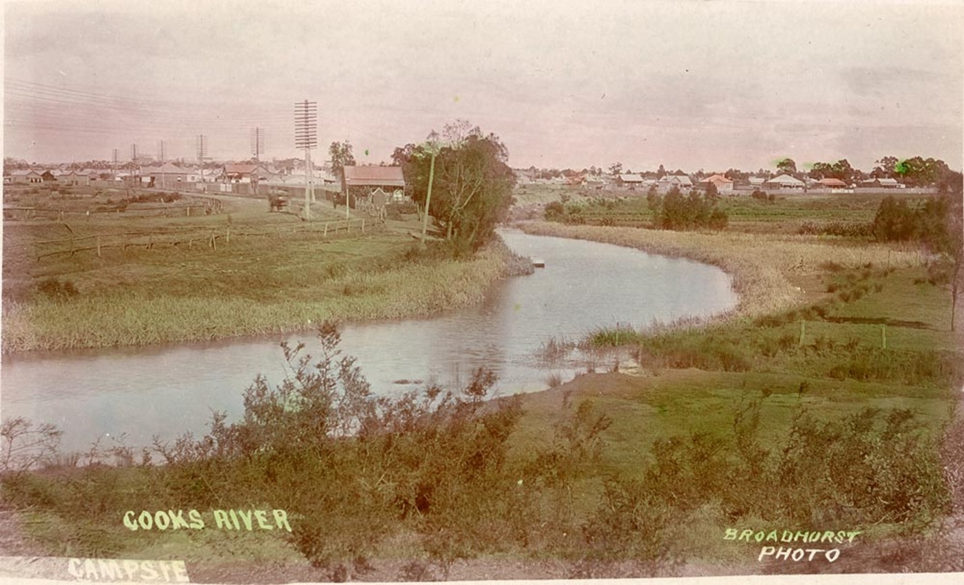
The Cooks River, a semi-mature tide-dominated drowned valley estuary, is a tributary of Botany Bay, located in south-western Sydney, New South Wales, Australia. The course of the urban waterway has been altered to accommodate various developments along its shore. It serves as part of a stormwater system for the of its watershed, and many of the original streams running into it have been turned into concrete lined channels. The tidal sections support significant areas of mangrove ecosystems and are used for recreational activities. Course The river begins at Graf Park, Yagoona, then flows in a roughly north-easterly direction to Chullora. It reaches its northernmost point at Strathfield, where it leads into a concrete open canal, no more than one metre wide and thirty centimetres deep. It then heads towards the south-east. Where Cooks River runs through Strathfield Golf Course, the concrete lining has been partly removed. Here the plants have returned and have created an e ... [...More Info...] [...Related Items...] OR: [Wikipedia] [Google] [Baidu] |
