|
Pamir Mountains
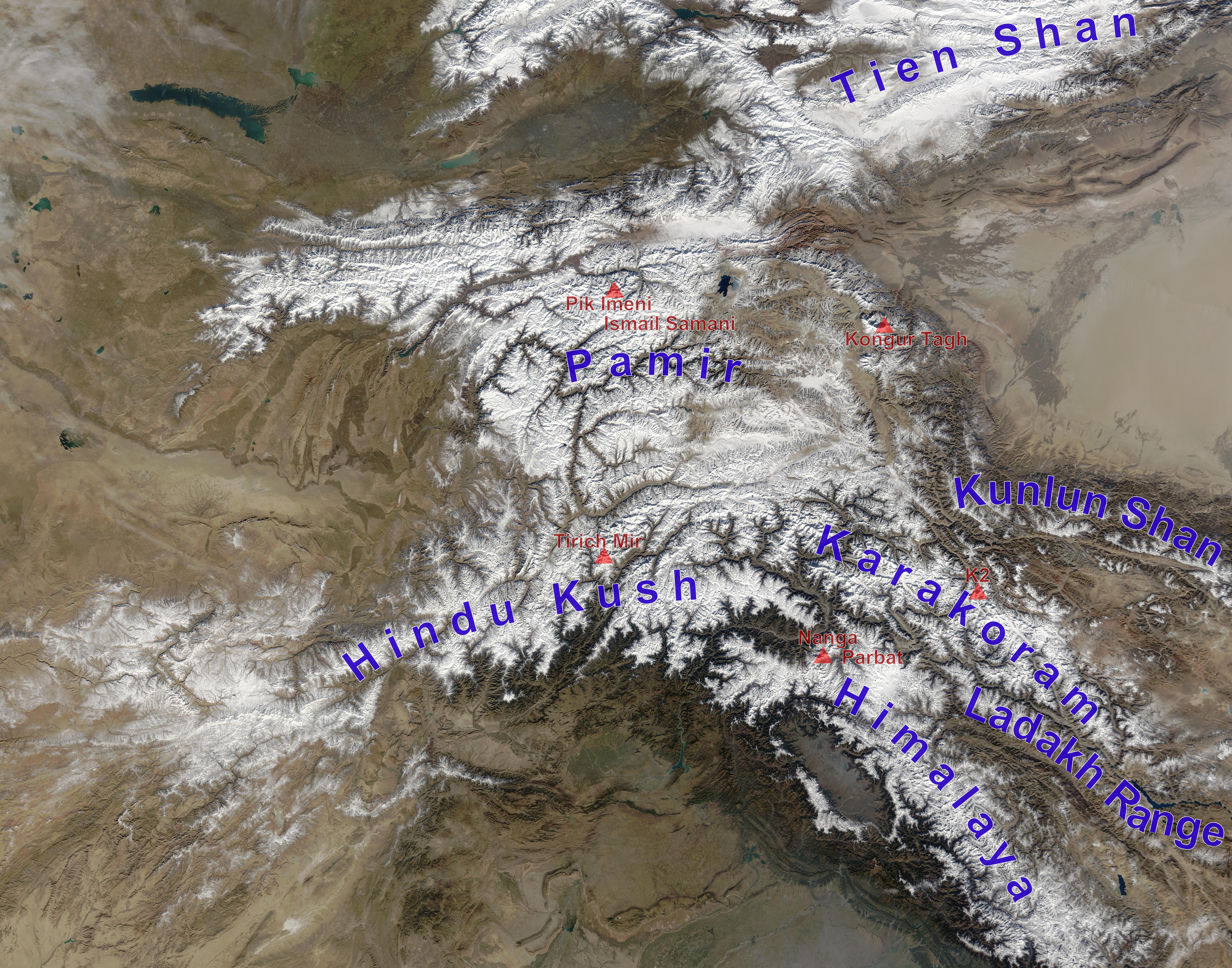
The Pamir Mountains are a Mountain range, range of mountains between Central Asia and South Asia. They are located at a junction with other notable mountains, namely the Tian Shan, Karakoram, Kunlun Mountains, Kunlun, Hindu Kush and the Himalayas, Himalaya mountain ranges. They are among the world's highest mountains. Much of the Pamir Mountains lie in the Gorno-Badakhshan region of Tajikistan. Spanning the border parts of four countries, to the south, they border the Hindu Kush mountains along Afghanistan's Wakhan Corridor in Badakhshan Province, Chitral District, Chitral and Gilgit-Baltistan regions of Pakistan. To the north, they join the Tian Shan mountains along the Alay Valley of Kyrgyzstan. To the east, they extend to the range that includes China's Kongur Tagh, in the "Eastern Pamirs", separated by the Yarkand River, Yarkand valley from the Kunlun Mountains. Since the Victorian era, they have been known as the "Roof of the World", presumably a translation from Persian ... [...More Info...] [...Related Items...] OR: [Wikipedia] [Google] [Baidu] |
Tajikistan
Tajikistan, officially the Republic of Tajikistan, is a landlocked country in Central Asia. Dushanbe is the capital city, capital and most populous city. Tajikistan borders Afghanistan to the Afghanistan–Tajikistan border, south, Uzbekistan to the Tajikistan–Uzbekistan border, west, Kyrgyzstan to the Kyrgyzstan–Tajikistan border, north, and China to the China–Tajikistan border, east. It is separated from Pakistan by Afghanistan's Wakhan Corridor. It has a population of over 10.7 million people. The territory was previously home to cultures of the Neolithic and the Bronze Age, including the Bactria–Margiana Archaeological Complex, Oxus civilization in west, with the Indo-Iranians arriving during the Andronovo culture. Parts of country were part of the Sogdia, Sogdian and Bactria, Bactrian civilizations, and was ruled by those including the Achaemenid Empire, Achaemenids, Alexander the Great, the Greco-Bactrian Kingdom, Greco-Bactrians, the Kushan Empire, Kushans, the Kid ... [...More Info...] [...Related Items...] OR: [Wikipedia] [Google] [Baidu] |
Tian Shan
The Tian Shan, also known as the Tengri Tagh or Tengir-Too, meaning the "Mountains of God/Heaven", is a large system of mountain ranges in Central Asia. The highest peak is Jengish Chokusu at high and located in Kyrgyzstan. Its lowest point is at the Turpan Depression, which is below sea level. The Tian Shan is sacred in Tengrism. Its second-highest peak is known as Khan Tengri, which can be translated as "Lord of the Spirits". At the 2013 Conference on World Heritage, the eastern portion of Tian Shan in western China's Xinjiang Region was listed as a World Heritage Site. The western portion in Kyrgyzstan, Kazakhstan, and Uzbekistan was then listed in 2016. Geography Tian Shan with the ancient Silk Road The Tian Shan range is located north and west of the Taklamakan Desert and directly north of the Tarim Basin. It straddles the border regions of Kazakhstan, Kyrgyzstan, Uzbekistan and Xinjiang in Northwest China. To the south, it connects with the Pamir Mountains ... [...More Info...] [...Related Items...] OR: [Wikipedia] [Google] [Baidu] |
Victorian Era
In the history of the United Kingdom and the British Empire, the Victorian era was the reign of Queen Victoria, from 20 June 1837 until her death on 22 January 1901. Slightly different definitions are sometimes used. The era followed the Georgian era and preceded the Edwardian era, and its later half overlaps with the first part of the ''Belle Époque'' era of continental Europe. Various liberalising political reforms took place in the UK, including expanding the electoral franchise. The Great Famine (Ireland), Great Famine caused mass death in Ireland early in the period. The British Empire had relatively peaceful relations with the other great powers. It participated in various military conflicts mainly against minor powers. The British Empire expanded during this period and was the predominant power in the world. Victorian society valued a high standard of personal conduct across all sections of society. The Victorian morality, emphasis on morality gave impetus to soc ... [...More Info...] [...Related Items...] OR: [Wikipedia] [Google] [Baidu] |
Helmand River
The Helmand river (Pashto/Dari: ; Ancient Greek: Ἐτύμανδρος, ''Etýmandros''; Latin: '), also spelled Helmend, or Helmund, Hirmand, is the longest river in Afghanistan and the primary watershed for the endorheic Sistan Basin. It originates in the Sanglakh Range of the Hindu Kush mountains in the northeastern part of Maidan Wardak Province, where it is separated from the watershed of the Kabul River by the Unai Pass. The Helmand feeds into the Hamun Lake on the border of Afghanistan and Iran. Etymology The name comes from the Avestan ''Haētumant'', literally "dammed, having a dam", which referred to the Helmand River and the irrigated areas around it. The word Haetumant is cognate with Sanskrit Setumatī meaning "one which has a dam." Geography The Helmand stretches for . It rises in the northeastern part of Maidan Wardak Province in the Hindu Kush mountains, about 40 km west of Kabul (), flowing southwestward through Daykundi Province and Uruzga ... [...More Info...] [...Related Items...] OR: [Wikipedia] [Google] [Baidu] |
Amu Darya
The Amu Darya ( ),() also shortened to Amu and historically known as the Oxus ( ), is a major river in Central Asia, which flows through Tajikistan, Turkmenistan, Uzbekistan, and Afghanistan. Rising in the Pamir Mountains, north of the Hindu Kush, the Amu Darya is formed by the confluence of the Vakhsh River, Vakhsh and Panj River, Panj rivers, in the Tigrovaya Balka Nature Reserve on the border between Afghanistan and Tajikistan, and flows from there north-westwards into the South Aral Sea, southern remnants of the Aral Sea. In its upper course, the river forms part of Afghanistan's northern border with Tajikistan, Uzbekistan, and Turkmenistan. In ancient history, the river was regarded as the boundary of Greater Iran with Turan, which roughly corresponded to present-day Central Asia.B. SpulerĀmū Daryā in Encyclopædia Iranica, online ed., 2009 The Amu Darya has a flow of about 70 cubic kilometres per year on average. Names In classical antiquity, the river was known as the ... [...More Info...] [...Related Items...] OR: [Wikipedia] [Google] [Baidu] |
Yarkand River
The Yarkand River (or Yarkent River, Yeh-erh-ch'iang Ho) is a river in the Xinjiang Uyghur Autonomous Region of western China. It originates in the Siachen Muztagh in a part of the Karakoram range and flows into the Tarim River or Neinejoung River, with which it is sometimes identified. However, in modern times, the Yarkand river drains into the Midstream Reservoir and exhausts its supply without reaching the Tarim river. The Yarkand River is approximately in length, with an average discharge of . A part of the river valley is known to the Kyrgyz people as Raskam Valley, and the upper course of the river itself is called the Raskam River. Another name of the river is Zarafshan. The area was once claimed by the ruler of Hunza. Course The river originates from the Siachen Muztagh in the Karakoram range in India– Sinkiang border region, south of the Kashgar Prefecture. It flows roughly due north until reaching the foot of the Kunlun Mountains. Then it flows northwest wh ... [...More Info...] [...Related Items...] OR: [Wikipedia] [Google] [Baidu] |
Alay Valley
The Alai Valley is a broad, dry valley running east–west across most of southern Osh Region of Kyrgyzstan in Central Asia. Geography The valley spreads over a length of east–west. It has a width of in the west, in the central part, and in the east. The altitude of the valley ranges from near Karamyk to at the Taunmurun Pass with an average altitude of about . The area of the valley is . The north side is the Alay Mountains which slope down to the Ferghana Valley. The south side is the Trans-Alay Range along the Tajikistan border, with Lenin Peak, (). The western or so is more hills than valley. On the east lies the Taunmurun (alternative spellings Taukmurun and Tongmurun) Pass and then more valley leading to the Erkeshtam border crossing to China. The eastern Kyzyl-Suu River, Kyzyl-Suu ('Red River') flows from the Taunmurun Pass past Erkeshtam toward Kashgar. The western Kyzyl-Suu flows west from the Taunmurun Pass and drains most of the valley, flowing on the north ... [...More Info...] [...Related Items...] OR: [Wikipedia] [Google] [Baidu] |
Gilgit-Baltistan
Gilgit-Baltistan (; ), formerly known as the Northern Areas, is a region administered by Pakistan as an administrative units of Pakistan, administrative territory and consists of the northern portion of the larger Kashmir region, which has been the subject of a Kashmir#Kashmir dispute, dispute between India and Pakistan since 1947 and between India and China since 1959.The application of the term "administered" to the various regions of Kashmir and a mention of the Kashmir dispute is supported by the WP:TERTIARY, tertiary sources (a) through (e), reflecting WP:DUE, due weight in the coverage. Although "controlled" and "held" are also applied neutrally to the names of the disputants or to the regions administered by them, as evidenced in sources (h) through (i) below, "held" is also considered politicised usage, as is the term "occupied," (see (j) below). (a) (subscription required) Quote: "Kashmir, region of the northwestern Indian subcontinent ... has been the subject of di ... [...More Info...] [...Related Items...] OR: [Wikipedia] [Google] [Baidu] |
Wakhan Corridor
The Wakhan Corridor (; ) is a narrow strip of territory in the Badakhshan province of Afghanistan. This corridor stretches eastward, connecting Afghanistan to Xinjiang, China. It also separates the Gorno-Badakhshan Autonomous Region of Tajikistan in the north from the Khyber Pakhtunkhwa and Gilgit-Baltistan regions in Pakistan in the south, the latter of which is also part of the disputed region of Kashmir.International Boundary Study of the Afghanistan–USSR Boundary (1983) by the US Bureau of Intelligence and Research Pg. 7 [...More Info...] [...Related Items...] OR: [Wikipedia] [Google] [Baidu] |
Encyclopædia Britannica
The is a general knowledge, general-knowledge English-language encyclopaedia. It has been published by Encyclopædia Britannica, Inc. since 1768, although the company has changed ownership seven times. The 2010 version of the 15th edition, which spans 32 volumes and 32,640 pages, was the last printed edition. Since 2016, it has been published exclusively as an online encyclopedia, online encyclopaedia. Printed for 244 years, the ''Britannica'' was the longest-running in-print encyclopaedia in the English language. It was first published between 1768 and 1771 in Edinburgh, Scotland, in three volumes. The encyclopaedia grew in size; the second edition was 10 volumes, and by its fourth edition (1801–1810), it had expanded to 20 volumes. Its rising stature as a scholarly work helped recruit eminent contributors, and the 9th (1875–1889) and Encyclopædia Britannica Eleventh Edition, 11th editions (1911) are landmark encyclopaedias for scholarship and literary ... [...More Info...] [...Related Items...] OR: [Wikipedia] [Google] [Baidu] |
Mountain
A mountain is an elevated portion of the Earth's crust, generally with steep sides that show significant exposed bedrock. Although definitions vary, a mountain may differ from a plateau in having a limited summit area, and is usually higher than a hill, typically rising at least above the surrounding land. A few mountains are inselberg, isolated summits, but most occur in mountain ranges. mountain formation, Mountains are formed through tectonic plate, tectonic forces, erosion, or volcanism, which act on time scales of up to tens of millions of years. Once mountain building ceases, mountains are slowly leveled through the action of weathering, through Slump (geology), slumping and other forms of mass wasting, as well as through erosion by rivers and glaciers. High elevations on mountains produce Alpine climate, colder climates than at sea level at similar latitude. These colder climates strongly affect the Montane ecosystems, ecosystems of mountains: different elevations hav ... [...More Info...] [...Related Items...] OR: [Wikipedia] [Google] [Baidu] |
Himalayas
The Himalayas, or Himalaya ( ), is a mountain range in Asia, separating the plains of the Indian subcontinent from the Tibetan Plateau. The range has some of the Earth's highest peaks, including the highest, Mount Everest. More than list of highest mountains on Earth, 100 peaks exceeding elevations of above sea level lie in the Himalayas. The Himalayas abut on or cross territories of Himalayan states, six countries: Nepal, China, Pakistan, Bhutan, India and Afghanistan. The sovereignty of the range in the Kashmir region is disputed among India, Pakistan, and China. The Himalayan range is bordered on the northwest by the Karakoram and Hindu Kush ranges, on the north by the Tibetan Plateau, and on the south by the Indo-Gangetic Plain. Some of the world's major rivers, the Indus River, Indus, the Ganges river, Ganges, and the Yarlung Tsangpo River, Tsangpo–Brahmaputra River, Brahmaputra, rise in the vicinity of the Himalayas, and their combined drainage basin is home to some 6 ... [...More Info...] [...Related Items...] OR: [Wikipedia] [Google] [Baidu] |


