|
Military Of Ryukyu
The military of the Ryukyu Kingdom defended the kingdom from 1429 until 1879. It had roots in the late army of Chūzan, which became the Ryukyu Kingdom under the leadership of King Shō Hashi. The Ryukyuan military operated throughout the Ryukyu Islands, the East China Sea, and elsewhere that Ryukyuan ships went, including the South China Sea and furher west, along the maritime silk road. Ryukyu primarily fought with other Ryukyuan kingdoms and chiefdoms, but also Japanese samurai from Satsuma Domain and Wokou, pirates. Soldiers were stationed aboard ships and Gusuku, Ryukyuan fortifications. The Ryukyuan military declined after the 17th century until it was abolished following the Disposition of Ryukyu, Japanese annexation of Ryukyu in 1879. History Early history ''Chūzan Seikan'', the first official history of Ryukyu, details the military victories of Shō Hashi. He first captured Ōzato Castle in 1403, then overthrew King Bunei (Ryukyu), Bunei of Chūzan in 1407,Historians ha ... [...More Info...] [...Related Items...] OR: [Wikipedia] [Google] [Baidu] |
Amawari
was a Ryukyuan Lord ( Aji) of Katsuren Castle, known for his ambitions for the throne of the Ryukyu Kingdom and scheme and attack against Gosamaru, Aji of Yomitanzan and Nakagusuku. Life Amawari was born to a peasant family in Yara, in Chatan Magiri (now Kadena)."Amawari." ''Okinawa rekishi jinmei jiten'' (沖縄歴史人名事典, "Encyclopedia of People of Okinawan History"). Naha: Okinawa Bunka-sha, 1996. p10. Overthrowing the Katsuren Aji, Amawari seized his domain. Taking advantage of opportunities for maritime trade, he gained a degree of wealth and power, and married Momoto-fumiagari, daughter of King Shō Taikyū, further solidifying his power. Anxious about Amawari's power, King Shō Taikyū asked Gosamaru, who had helped Shō Taikyū's father invade Hokuzan in 1416, to build Nakagusuku Castle is a ''gusuku'' in the village of Kitanakagusuku, Okinawa, Japan. It is one of a number of castles built on the island of Okinawa by the Ryukyu Kingdom now in ruins. ... [...More Info...] [...Related Items...] OR: [Wikipedia] [Google] [Baidu] |
Chūzan Seikan
, compiled in 1650 by Shō Shōken, is the first official history of the Ryūkyū Kingdom. In six scrolls, the main text occupies five and an accompanying summary the sixth. Unlike later official histories such as ''Chūzan Seifu'' and '' Kyūyō'', which were written in kanbun, ''Chūzan Seikan'' is largely written in Japanese, other than for the summary and a number of quotes in Chinese. The account of Shō Nei, whose reign saw invasion and subjugation by Satsuma, opens with the statement that the kingdom had been in subordinate vassal status to the Shimazu clan since the Eikyō era. The account of the siring of Shunten by Minamoto no Tametomo was similarly exploited during the Meiji period and after to help legitimize the annexation of the kingdom and its reconfiguration first as the Ryūkyū Domain and subsequently as Okinawa Prefecture is the southernmost and westernmost prefecture of Japan. It consists of three main island groups—the Okinawa Islands, the Sakishima I ... [...More Info...] [...Related Items...] OR: [Wikipedia] [Google] [Baidu] |
Nago Castle
is a Ryukyuan ''gusuku'' in Nago, Okinawa. It was built in the 14th century and served as the home of the Aji of Nago Magiri. In 1416, the army of Chūzan, led by Shō Hashi, attacked and captured the castle during the invasion of Hokuzan , also known as before the 18th century, located in the north of Okinawa Island, was one of three independent political entities which controlled Okinawa in the 14th century during Sanzan period. The political entity was identified as a tiny c .... References External linksOne reference Castles in Okinawa Prefecture Nago, Okinawa {{castle-stub ... [...More Info...] [...Related Items...] OR: [Wikipedia] [Google] [Baidu] |
Kunigami, Okinawa
is a village in Kunigami District, Okinawa Prefecture, Japan. It occupies the north tip of Okinawa Island, with the East China Sea to the west, Pacific Ocean to the east, and villages of Higashi and Ōgimi to the south. As of 2015, the village has a population of 4,908 and a population density of 25.20 persons per km2. The total area is 194.80 km2. History According to '' Chūzan Seikan'', the goddess Amamikyu consecrated the first utaki in Asa Forest at Hedo, in what is now Kunigami; the forest is also mentioned in '' Omoro Sōshi''. Ceramics from the Jōmon-period resemble those found in the Amami Islands. ''Chūzan Seikan'' records the prayers of the Kunigami council for the recovery of Shō Sei after an abortive attempt to occupy Amami Ōshima in 1537, while '' Kyūyō'' recounts the appointment of the son of the Kunigami Oyakata as '' aji'' after the successful takeover of the Amami Islands by Shō Gen in 1571. Kunigami District was established in 1896 and, ... [...More Info...] [...Related Items...] OR: [Wikipedia] [Google] [Baidu] |
Nago, Okinawa
is a city located in the northern part of Okinawa Island, Okinawa Prefecture, Japan. As of December 2012, the city has an estimated population of 61,659 and a population density of 293 persons per km2. Its total area is 210.30 km2. Geography Nago City is located in the northern part of Okinawa Island and with an area of 210.33 km², it represents 9.2% of Okinawa Island’s surface, coming third behind Taketomi (334.02 km²) and Ishigaki (229.00 km²) in Okinawa Prefecture, but first on Okinawa Island. The city is bordered by the sea both on the west and the east. About 10% of the city area is occupied by U.S. military bases. Administrative divisions The city includes fifty-six wards. *Abu (安部) *Asahikawa (旭川) *Awa (安和) *Bīmata (為又) *Burikena (振慶名) *Futami (二見) *Gabu (我部) *Gabusoka (我部祖河) *Genka (源河) *Goga (呉我) *Henoko (辺野古) *Inamine (稲嶺) *Isagawa (伊差川) *Katsuyama (勝山) *Kawakami (川上) *Kayō (嘉 ... [...More Info...] [...Related Items...] OR: [Wikipedia] [Google] [Baidu] |
Shuri, Okinawa
is a district of the city of Naha, Okinawa, Japan. Formerly a separate city in and of itself, it was once the royal capital of the Ryūkyū Kingdom, hence the name. A number of famous historical sites are located in Shuri, including Shuri Castle, the Shureimon gate, Sunuhyan-utaki (a sacred space of the native Ryukyuan religion), and royal mausoleum Tamaudun, all of which are designated World Heritage Sites by UNESCO. Originally established as a castle town surrounding the royal palace, Shuri ceased to be the capital when the kingdom was abolished and incorporated into Japan as Okinawa prefecture. In 1896, Shuri was made a of the new prefectural capital, Naha, though it was made a separate city again in 1921. In 1954, it was merged again into Naha. History Medieval and early modern periods Shuri Castle was first built during the reign of Shunbajunki (r. 1237–1248), who ruled from nearby Urasoe Castle. Kerr, George H. (2000). '' Okinawa: the History of an Island People''. ... [...More Info...] [...Related Items...] OR: [Wikipedia] [Google] [Baidu] |
Yomitan, Okinawa
is a village located in Nakagami District, Okinawa Prefecture, Japan. Geography Yomitan is located on the western coast of the central part of Okinawa Island. The village is bound to the north by Onna, to the east by Okinawa City, to the south by Kadena, and to the west by the East China Sea. 31.5% of the land area is zoned for agriculture, 35.7% is zoned as forest, 12.3% is zoned for housing, and the remaining 20.6% is zoned for other uses. Administrative divisions The village includes twenty-three wards. *Furugen (古堅) *Gima (儀間) *Hija (比謝) *Hijabashi (比謝矼) *Iramina (伊良皆) *Kina (喜名) *Makibaru (牧原) *Nagata (長田) *Nagahama (長浜) *Namihira (波平) *Ōki (大木) *Ōwan (大湾) *Oyashi (親志) *Senaha (瀬名波) *Sobe (楚辺) **Ōsoe (大添) *Takashiho (高志保) *Toguchi (渡具知) *Tokeshi (渡慶次) *Toya (都屋) *Uechi (上地) *Uza (宇座) *Zakimi (座喜味) History Originally known as , it was part of the Kingdom o ... [...More Info...] [...Related Items...] OR: [Wikipedia] [Google] [Baidu] |
Urasoe, Okinawa
is a city located in Okinawa Prefecture, Japan. The neighboring municipalities are Naha to the south, Ginowan to the north, and Nishihara to the east. As of February 2024, the city has an estimated population of 115,518 and a population density of 6,051.2 persons per km2. The total area is 19.09 km2. United States Marine Corps base Camp Kinser is located on the city's coast. Etymology The name "Urasoe" is made up of two kanji characters. The first, , means "a coastal area", and the second, , means "ruling" or "uniting". The name is a reference to "ruling over many areas". However, what appears to be an older form of this word is attested in Old Okinawan under the forms ''*uraosoi'' うらおそい and ''*uraosoe'' うらおそへ. Geography Urasoe sits to the south of Okinawa Island. Urasoe is rugged and hilly to the east, and the city slopes gently to the East China Sea in the west. Urasoe, while formerly agricultural, has become heavily urbanized due to its proxim ... [...More Info...] [...Related Items...] OR: [Wikipedia] [Google] [Baidu] |
Hananchi
was a local ruler of Okinawa Island, who was given the title of King of Sanhoku. Contemporary sources on Han'anchi are very scarce. He first appeared in Chinese diplomatic records in 1396 and his last contact was of 1415. His blood relationship with Min, the preceding King of Sanhoku, is unknown. After 1415, the King of Sanhoku did not contact China again. The Chinese records suggest that the Chinese had no information on when and how the king disappeared. Because the King of Chūzan continued tributary missions, the Chinese later speculated that the Kings of Sannan and Sanhoku had been removed by the King of Chūzan. His real name is unknown. Modern attempts to decipher the enigmatic un-Okinawan name ''Han'anchi'' point to Haneji (羽地), a settlement in northern Okinawa (part of modern-day Nago City). ''Han'anchi'' can be either a corrupt form of ''Haneji'' or a contraction of ''Haneji Aji'' (local ruler of Haneji). The name suggests some connection to the settlement, but it ... [...More Info...] [...Related Items...] OR: [Wikipedia] [Google] [Baidu] |
Hokuzan
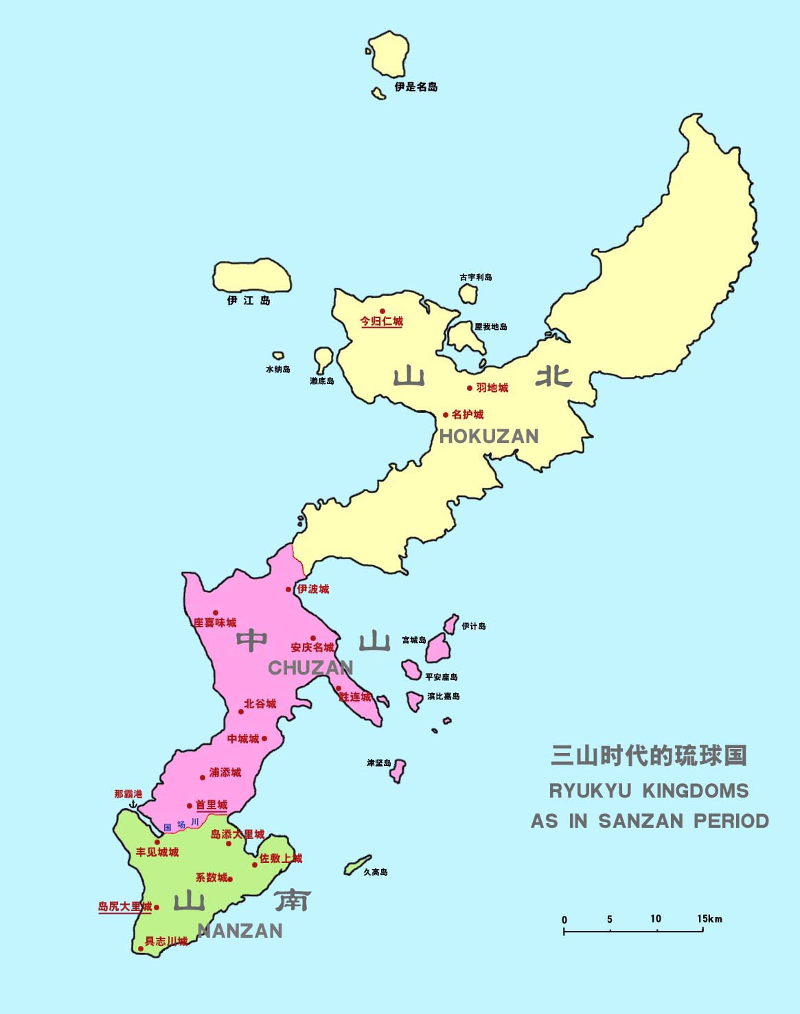
, also known as before the 18th century, located in the north of Okinawa Island, was one of three independent political entities which controlled Okinawa in the 14th century during Sanzan period. The political entity was identified as a tiny country, a kingdom, or a principality by modern historians, however the ruler of Hokuzan was in fact not "kings" at all, but petty lords with their own retainers owing their direct service, and their own estates. Okinawa, previously controlled by a number of local chieftains or lords, loosely bound by a paramount chieftain or king of the entire island, split into these three more solidly defined kingdoms within a few years after 1314; the Sanzan period thus began, and would end roughly one hundred years later, when Chūzan's King Shō Hashi conquered Hokuzan in 1416 and Nanzan in 1429. After the unification of Ryukyu, Hokuzan became one of three nominal '' fu'' (, lit. "prefectures") of the Ryukyu Kingdom without administrative function. ... [...More Info...] [...Related Items...] OR: [Wikipedia] [Google] [Baidu] |
Aji (Ryukyu)
Aji An ''aji'', or ''anji'' was a ruler of a small kingdom in the history of the Ryukyu Islands. The word later became a title and rank of nobility in the Ryukyu Kingdom. It ranked next below a prince among nobility. The sons of princes and the eldest sons of ''aji'' became ''aji.'' An ''aji'' established a noble family equivalent to a shinnōke of Japan. The ''aji'' arose around the twelfth century as local leaders began to build ''gusuku'' (Ryukyuan castles). Shō Hashi was an ''aji'' who later unified Okinawa Island as king. The title ''aji'' variously designated sons of the king and regional leaders. During the Second Shō Dynasty, when the ''aji'' settled near Shuri Castle, the word came to denote an aristocrat in the castle town. A pattern for addressing a male ''aji'' began with the place he ruled and ended with the word ''aji'', for example, "Nago ''Aji''". For women, the suffix ''ganashi'' or ''kanashi'' (加那志) followed: "Nago ''Aji-ganashi''". Etymology The k ... [...More Info...] [...Related Items...] OR: [Wikipedia] [Google] [Baidu] |
Shuri Castle
is a Ryukyu Islands, Ryukyuan ''gusuku'' castle in Shuri, Okinawa, Shuri, Okinawa Prefecture, Japan. Between 1429 and 1879, it was the palace of the Ryukyu Kingdom, before becoming largely neglected. In 1945, during the Battle of Okinawa, it was almost completely destroyed. After the war, the castle was re-purposed as a university campus. Beginning in 1992, the central citadel and walls were largely reconstructed on the original site based on historical records, photographs, and memory. In 2000, Shuri Castle was designated as a World Heritage Site, as a part of the Gusuku Sites and Related Properties of the Kingdom of Ryukyu. On the morning of 31 October 2019, the main courtyard structures of the castle were again destroyed in a fire. Reconstruction is ongoing and is expected to be fully completed by the autumn of 2026. History The date of construction is uncertain, but it was clearly in use as a castle during the Sanzan period (1322–1429). It is thought that it was probab ... [...More Info...] [...Related Items...] OR: [Wikipedia] [Google] [Baidu] |


