|
Medchal–Malkajgiri District
Medchal−Malkajgiri district is a district in the Indian state of Telangana. Shamirpet is the headquarter of the district. It is the second most populous district in the state with a population of 2.5 million and also 91.40% urbanized district in the state of Telangana, standing next only to Hyderabad district which has a population of 4 million. The district shares boundaries with Hyderabad, Medak, Sangareddy, Y. Bhuvanagiri, Siddipet and Rangareddy districts.The most part of the district consist of Hyderabad City (GHMC) Geography The district is spread over an area of .It is situated 505 metres above sea level. The landmark consists of rocky terrain and monolithic rocks in the outskirts of the city. Demographics census of India, the district is the second most populous district in the state with a population of 2,440,073. Medchal-Malkajgiri has a sex ratio of 957 females per 1000 males and a literacy rate of 82.49%. 285,044 (11.68%) are under 6 years of age. 2, ... [...More Info...] [...Related Items...] OR: [Wikipedia] [Google] [Baidu] |
Districts Of Telangana
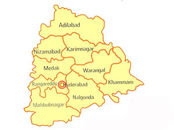
The Indian state of Telangana has 33 districts, each headed by a District collector. History Telangana region of Hyderabad State (1948–56), Hyderabad State consisted of 8 Districts in 1948 when it was inducted in Dominion of India; they are Hyderabad district, India, Hyderabad, Mahabubnagar district, Mahbubnagar, Medak district, Medak, Nalgonda district, Nalgonda, Nizamabad district, Nizamabad, Adilabad district, Adilabad, Karimnagar district, Karimnagar and Warangal district, Warangal districts. Khammam district was created by bifurcation of Warangal district on 1 October 1953. Andhra Pradesh was formed by merging Telangana region of Hyderabad State (1948–1956), Hyderabad State and Andhra State, Andhra state on 1 November 1956. Bhadrachalam division and Aswaraopeta, Aswaraopet taluka parts was merged in Khammam district, Khammam district from Godavari districts for better Administration. Hyderabad district was split into Hyderabad Urban District and Hyderabad Rural Dist ... [...More Info...] [...Related Items...] OR: [Wikipedia] [Google] [Baidu] |
National Highway 44 (India)
National Highway 44 (NH 44) is a major north–south National Highway in India and is the longest in the country. It passes through the Union Territory of Jammu and Kashmir, in addition to the states of Punjab, Haryana, Delhi, Uttar Pradesh, Rajasthan, Madhya Pradesh, Maharashtra, Telangana, Andhra Pradesh, Karnataka, and Tamil Nadu. It came into being by merging seven national highways, in full or part, starting with the Jammu–Srinagar National Highway (former NH 1A) from Srinagar in Jammu and Kashmir, former NH 1 in Punjab and Haryana ending at Delhi, part of former NH 2 starting from Delhi and ending at Agra, former NH 3 (popularly known as Agra-Bombay National Highway) from Agra to Gwalior, former NH 75 and former NH 26 to Jhansi, and former NH 7 via Lakhnadon, Seoni, Nagpur, Adilabad, Nirmal, Hyderabad, Kurnool, Anantapur,Chikkaballapur, Devanahalli, Bangalore, Hosur, Krishnagiri, Dharmapuri, Salem, Namakkal, Karur, Dindigul, Madurai, Virudhuna ... [...More Info...] [...Related Items...] OR: [Wikipedia] [Google] [Baidu] |
Registrar General And Census Commissioner Of India
Registrar General and Census Commissioner of India, founded in 1961 by the Government of India Ministry of Home Affairs, for arranging, conducting and analysing the results of the demographic surveys of India including Census of India and Linguistic Survey of India. The position of Registrar General and Census Commissioner is now held by a civil servant holding the rank of Additional Secretary. History The Indian Census is the largest single source of a variety of statistical information on different characteristics of the people of India. The first census of India was conducted in the 1872 and attempted to collect data across as much of the country as was feasible. The first of the decennial censuses took place in 1881. Until 1961, responsibility for arranging, conducting and analysing the results of the census was exercised by a temporary administrative structure that was put in place for each census and then dismantled. From that time on, the office of the Registrar G ... [...More Info...] [...Related Items...] OR: [Wikipedia] [Google] [Baidu] |
Census Of India
The decennial census of India has been conducted 15 times, as of 2011. While it has been undertaken every 10 years, beginning in 1872 under Viceroy Lord Mayo, the first complete census was taken in 1872. Post 1949, it has been conducted by the Registrar General and Census Commissioner of India under the Ministry of Home Affairs, Government of India The Government of India (ISO 15919, ISO: Bhārata Sarakāra, legally the Union Government or Union of India or the Central Government) is the national authority of the Republic of India, located in South Asia, consisting of States and union t .... All the censuses since 1951 were conducted under the 1948 Census of India Act, which predates the Constitution of India. The 1948 Census of India Act does not bind the Union Government to conduct the census on a particular date or to release its data in a notified period. The last census was held in 2011, whilst the next was to be held in 2021 before it was postponed due to the COVID ... [...More Info...] [...Related Items...] OR: [Wikipedia] [Google] [Baidu] |
Greater Hyderabad Municipal Corporation
The Greater Hyderabad Municipal Corporation (GHMC) is the civic body that oversees Hyderabad, the capital and largest city of the Indian state of Telangana. It is the local government for the city of Hyderabad. It is one of the largest municipal corporations in India with a population of 7.9 million and an area of 650 km2. History Hyderabad Municipal Board (1869–1933) In 1869, municipal administration was first introduced for the city of Hyderabad. The city of Hyderabad was divided into four and the suburbs of Chaderghat were divided into five divisions. The whole management of both the city and the suburbs was handled by the then City Police Commissioner, Kotwal-e-Baldia. Hyderabad Municipal Corporation (1933–2007) In 1933, Chaderghat Municipality was merged with Hyderabad Municipality to form Hyderabad Municipal Corporation and was given statutory status under the Hyderabad Municipal Act. During the following year (1934), the first elections were held for Mu ... [...More Info...] [...Related Items...] OR: [Wikipedia] [Google] [Baidu] |
Rangareddy District
Ranga Reddy district is a district in the Indian state of Telangana. The district headquarters is located at Kongara Kalan Village, Ibrahimpatnam Mandal. The district was named after the former deputy chief minister of the United Andhra Pradesh, K. V. Ranga Reddy. The district shares boundaries with Nalgonda, Yadadri Bhuvanagiri, Hyderabad, Medchal–Malkajgiri, Nagarkurnool, Mahabubnagar, Sangareddy and Vikarabad districts. History Dynasties Chronological order of kingdoms who ruled Rangareddy and Hyderabad regions is as follows: 1. Nandas 2. Mauryas 3. Satavahanas 4. Ikshvakus 5. Vakatakas 6. Vishnukundinas 7. Badami Chalukyas 8. Rashtrakutas 9. Kalyani Chalukyas 10. Kakatiyas 11. Delhi Sultanate(Khilji & Tughlaq dynasties) 12. Musunuri Nayakas 13. Recherla Padmanayakas(Rachakonda & Devarakonda Velamas) 14. Bahamanis 15. Qutub Shahis 16. Mughals 17. Asaf Jahis Formation of District The dist ... [...More Info...] [...Related Items...] OR: [Wikipedia] [Google] [Baidu] |
Siddipet District
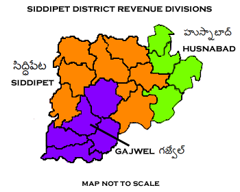
Siddipet district is a district in the Indian state of Telangana. Its headquarters is Siddipet. This district contains a part of the Hyderabad Metropolitan Region(Markook, Telangana, Markook Mulugu Saraswati Temple, Wargal, Wargal) The district shares boundaries with Jangaon district, Jangaon, Sircilla district, Sircilla, Karimnagar district, Karimnagar, Kamareddy district, Kamareddy, Hanamkonda district, Hanamkonda, Yadadri Bhuvanagiri district, Yadadri, Medchal district, Medhchal and Medak district, Medak districts. Geography This district is bounded by Rajanna Sircilla district in the north, Karimnagar district in the northeast, Jangaon district in the east, Yadadri Bhuvanagiri, Yadadri Bhuvanagiri district in the south, Medchal-Malkajgiri district, Medchal district in the southwest, Medak district in the west and Kamareddy district in the northwest. Demographics At the time of the 2011 census, Siddipet district has a population of 1,012,065. Siddipet has a sex ratio o ... [...More Info...] [...Related Items...] OR: [Wikipedia] [Google] [Baidu] |
Bhuvanagiri District
Yadadri Bhuvanagiri district is a district in the Indian state of Telangana. The administrative headquarters is located at Bhuvanagiri which is also known as Bhongiri. The district shares boundaries with Suryapet, Nalgonda, Jangaon, Siddipet, Medchal-Malkajgiri and Rangareddy districts. It was carved out of Nalgonda district on 11 October 2016 during a large reorganisation of the districts of Telangana. Geography The district is spread over an area of . Demographics Census of India, Yadadri Bhuvanagiri district has a population of 770,833. Yadadri Bhuvanagiri has a sex ratio of 974 females per 1000 males and a literacy rate of 65.67%. 79,962 (10.37%) were under 6 years of age. 123,165 (15.98%) lived in urban areas. Scheduled Castes and Scheduled Tribes made up 136,916 (17.76%) and 43,774 (5.68%) of the population respectively. At the time of the 2011 census, 90.54% of the population spoke Telugu, 5.00% Lambadi and 3.42% Urdu as their first language. Administrativ ... [...More Info...] [...Related Items...] OR: [Wikipedia] [Google] [Baidu] |
Sangareddy District
Sangareddy district is a district located in the western region of the Indian state of Telangana. This district contains a part of the Hyderabad Metropolitan Region. Sangareddy is the district headquarters of the district. It was named after the ruler Sanga, the son of queen Shankaramba, who was the ruler of Medak during the period of Nizams. The district shares boundaries with Medak, Medchal, Vikarabad, Kamareddy and Rangareddy districts and with the state boundary of Karnataka. Geography The district is spread over an area of . Demographics At the time of the 2011 census, Sangareddy district had a population of 1,526,026. Sangareddy has a sex ratio of 965 females per 1000 males and a literacy rate of 64.03%. 194,674 (12.76%) were under 6 years of age. 529,965 (34.73%) lived in urban areas. Scheduled Castes and Scheduled Tribes made up 276,595 (18.13%) and 86,410 (5.66%) of the population respectively. At the time of the 2011 census, 71.24% of the population sp ... [...More Info...] [...Related Items...] OR: [Wikipedia] [Google] [Baidu] |
Medak District
Medak district is located in the western region of the Indian state of Telangana. Medak is the district headquarters. The district shares boundaries with Sangareddy, Kamareddy, Siddipet and Medchal-Malkajgiri districts. History Traces of Neolithic and Megalithic culture were found at Edithanur and Wargal village hillocks in the district. Rock paintings were found at Edithanur and Hastallapur rocks. Nizam state In the 20th century Medak district was a part of Nizam princely State before independence and merged into Hyderabad State in Independent India. Qutub Shahis named it as Gulshanabad which means '"city of gardens'" due to its greenery. Geography The district is spread over an area of . Economy In 2006 the Indian government named Medak one of the country's 250 most backward districts (out of a total of 640). It is one of the thirteen districts in Andhra Pradesh currently receiving funds from the Backward Regions Grant Fund Programme (BRGF). With the emergen ... [...More Info...] [...Related Items...] OR: [Wikipedia] [Google] [Baidu] |
Indian State
India is a federal union comprising 28 states and 8 union territories, for a total of 36 subnational entities. The states and union territories are further subdivided into 800 districts and smaller administrative divisions by the respective subnational government. The states of India are self-governing administrative divisions, each having a state government. The governing powers of the states are shared between the state government and the union government. On the other hand, the union territories are directly governed by the union government. History 1876–1919 The British Raj was a very complex political entity consisting of various imperial divisions and states and territories of varying autonomy. At the time of its establishment in 1876, it was made up of 584 constituent states and the directly ruled territories of the Crown. The entire empire was divided into provinces and agencies. A province consisted of territory under the direct rule of the Empe ... [...More Info...] [...Related Items...] OR: [Wikipedia] [Google] [Baidu] |


