|
Itasca County, Minnesota
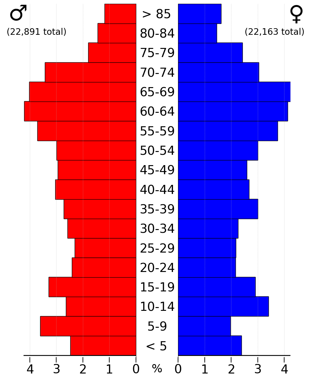
Itasca County ( ) is a county located in the Iron Range region of the U.S. state of Minnesota. As of the 2020 census, the population was 45,014. Its county seat is Grand Rapids. The county is named after Lake Itasca, which is in turn a shortened version of the Latin words ''veritas caput'', meaning 'truth' and 'head', a reference to the source of the Mississippi River. Portions of the Bois Forte and Leech Lake Indian reservations are in the county. History The boundary of Itasca County was first formed in 1849, upon the creation of the Minnesota Territory. It was originally a much larger county, which covered many of today's northeastern Minnesota counties. The original Itasca County stretched over Cook, Lake, Saint Louis, Koochiching, eastern Lake of the Woods, eastern Beltrami, Itasca, northern Aitkin, and northern Carlton counties, today in Minnesota. Itasca County was originally named for Lake Itasca (no longer in the county's present borders), which was determined to ... [...More Info...] [...Related Items...] OR: [Wikipedia] [Google] [Baidu] |
Lake Itasca
Lake Itasca ( ) is a small glacial lake, approximately in area. It is located in Itasca State Park, in south-eastern Clearwater County, in the Headwaters area of north-central Minnesota, and is notable for being the headwater of the Mississippi River. It has an average depth of and is above sea level. The Ojibwe name for the lake is ''Omashkoozo-zaaga'igan'' (Elk Lake). The first European explorers in the area were French Canadian and they named the lake ''Lac Labiche'' (Doe Lake, often mistranslated as Elk Lake). The name was later changed by Henry Schoolcraft to "Itasca", coined from a combination of the Latin phrase ''veritas caput'' ("true head f the Mississippi). It is one of several examples of pseudo-Native American place names created by Schoolcraft. Source of the Mississippi River It is the primary source of the Mississippi River which flows 2,340 mi (3,770 km) to the Gulf of Mexico. There are several tributaries that flow (most or all of the year) int ... [...More Info...] [...Related Items...] OR: [Wikipedia] [Google] [Baidu] |
Glacial History Of Minnesota
The glacial history of Minnesota is most defined since the onset of the last glacial period, which ended some 10,000 years ago. Within the last million years, most of the Midwestern United States and much of Canada were covered at one time or another with an ice sheet. This continental glacier had a profound effect on the surface features of the area over which it moved. Vast quantities of rock and soil were scraped from the glacial centers to its margins by slowly moving ice and redeposited as drift or till. Much of this drift was dumped into old preglacial river valleys, while some of it was heaped into belts of hills ( terminal moraines) at the margin of the glacier. The chief result of glaciation has been the modification of the preglacial topography by the deposition of drift over the countryside. However, continental glaciers possess great power of erosion and may actually modify the preglacial land surface by scouring and abrading rather than by the deposition of the dri ... [...More Info...] [...Related Items...] OR: [Wikipedia] [Google] [Baidu] |
Minnesota State Highway 1
Minnesota State Highway 1 (MN 1) is a state highway across northern Minnesota, United States, which runs from North Dakota Highway 54 (ND 54) at the North Dakota state line (at the Red River in Oslo) and continues east to its eastern terminus at MN 61 at the unincorporated community of Illgen City in Beaver Bay Township on the North Shore of Lake Superior. At in length, MN 1 is the longest state route in Minnesota. Route description MN 1 serves as an east–west route between Oslo, Warren, Thief River Falls, Red Lake, Northome, Cook, Tower, Ely, and Beaver Bay Township. The roadway passes through the following forests: * Finland State Forest in Lake County * Superior National Forest in Lake and Saint Louis counties * Bear Island State Forest in Lake and Saint Louis counties * Kabetogama State Forest in Saint Louis County * George Washington State Forest in Itasca County * Koochiching State Forest in Koochiching County The route runs ... [...More Info...] [...Related Items...] OR: [Wikipedia] [Google] [Baidu] |
MN-1 zone in the European Neogene
{{Letter-NumberCombDisambig ...
MN1, MN 1, or MN-1 may be: * Minnesota State Highway 1 * Ulaanbaatar, ISO 3166-2 geocode for the capital of Mongolia * Minnesota's 1st congressional district * The ''MN1'' gene on human chromosome 22 * MN 1 (biostratigraphic zone), a biostratigraphic Biostratigraphy is the branch of stratigraphy which focuses on correlating and assigning relative ages of rock strata by using the fossil assemblages contained within them.Hine, Robert. "Biostratigraphy." ''Oxford Reference: Dictionary of Biology ... [...More Info...] [...Related Items...] OR: [Wikipedia] [Google] [Baidu] |
US 169 (MN)
U.S. Highway 169 (US 169) is a major north–south United States Numbered Highway in the state of Minnesota, connecting the Minnesota River valley with the Minneapolis-Saint Paul, Twin Cities and the Iron Range. Much of the route is built to Limited-access road, expressway or freeway standards. Route description US 169 enters Minnesota near Elmore, Minnesota, Elmore as a two-lane, undivided highway, continuing as such through the majority of Blue Earth, Minnesota, Blue Earth. Near the northern outskirts of the town, it expands to a four-lane, divided highway, subsequently crossing Interstate 90 in Minnesota, Interstate 90 (I-90). Soon after, it reverts to its original two-lane size. Roughly southwest of Mankato, Minnesota, Mankato, US 169 and Minnesota State Highway 60, State Highway 60 (MN 60) merge to a single expressway through Mankato. In North Mankato, Minnesota, North Mankato, MN 60 moves from a Concurrency (road), concurrency with U ... [...More Info...] [...Related Items...] OR: [Wikipedia] [Google] [Baidu] |
US 71
U.S. Route 71 or U.S. Highway 71 (US 71) is a major north–south United States highway that extends for over 1500 miles (2500 km) in the central United States. This original 1926 route has remained largely unchanged by encroaching Interstate highways. Currently, the highway's northern terminus is in International Falls, Minnesota at the Canada–US border, at the southern end of the Fort Frances-International Falls International Bridge to Fort Frances, Ontario. U.S. Route 53 also ends here. On the other side of the bridge, Trans-Canada Highway (Ontario Highway 11) is an east–west route while Ontario Highway 71 is a north–south route. US 71's southern terminus is between Port Barre and Krotz Springs, Louisiana at an intersection with U.S. Route 190. For the entirety south of Kansas City, Missouri, US 71 runs parallel and concurrent with the existing and future Interstate 49. North of Kansas City, US 71 runs halfway between Interstate 29 and Interstate 35, which split ... [...More Info...] [...Related Items...] OR: [Wikipedia] [Google] [Baidu] |
US 2
U.S. Route 2 or U.S. Highway 2 (US 2) is an east–west United States Numbered Highway spanning across the northern continental United States. US 2 consists of two segments connected by various roadways in southern Canada. Unlike some routes, which are disconnected into segments because of encroaching Interstate Highways, the two portions of US 2 were designed to be separate in the original 1926 highway plan. The western segment of US 2 begins at an interchange with Interstate 5 (I-5) and State Route 529 (Maple Street) in Everett, Washington, and ends at I-75 in St. Ignace, Michigan. The eastern segment of US 2 begins at US 11 in Rouses Point, New York, and ends at I-95 in Houlton, Maine. As its number indicates, it is the northernmost east–west U.S. Highway in the country. It is the lowest primary-numbered east–west U.S. Highway, whose numbers otherwise end in zero, and was so numbered to avoid a US 0. Sections o ... [...More Info...] [...Related Items...] OR: [Wikipedia] [Google] [Baidu] |
Deer Lake (Itasca County, Minnesota)
Deer Lake is located in Itasca County, Minnesota about north of Grand Rapids and about northeast of Deer River. The lake covers and is roughly long and wide. Deer Lake is fed by three sources: rainfall, underwater springs, and one inlet from Little Deer Lake. It belongs to a chain of pristine lakes, feeding Bay Lake - headwaters of the mighty Deer River (namesake of the town) which feeds White Oak Lake (part of the Mississippi River). Otter, Moose, Little Moose, Fawn, and Cottonwood Lakes also feed Bay Lake. Often called the "Lake of the Changing Colors", Deer Lake's crystal-clear water displays a wide range of magnificent colors on sunny days - divulging the locations of its perilous rocky bars to unfamiliar boaters. While Deer Lake ranks among the clearest lakes of Minnesota, what distinguishes it from its peers is its many interesting islands. In 1998, the DNR and Deer Lake Association jointly acquired Bear Island to preserve its undeveloped charm. Although bears ar ... [...More Info...] [...Related Items...] OR: [Wikipedia] [Google] [Baidu] |
Pokegama Dam
:''not to be confused with Pokegama Lake, Pine County, Minnesota'' Pokegama Lake Dam (National ID MN00584) is a dam in Cohasset, Itasca County, Minnesota, northwest of the city of Grand Rapids. The concrete and timber crib dam was constructed in 1884 by the United States Army Corps of Engineers, with a height of , and a length of at its crest. It impounds the Upper Mississippi River for flood control, navigation, and municipal drinking water. Rebuilt in 1936, the dam is owned and operated by the Mississippi Valley Division of the Corps of Engineers. The dam creates a system of connected reservoirs with a total maximum capacity of 120,000 acre-feet, and a normal capacity of 82,000 acre-feet: Jay Gould Lake, Little Jay Gould Lake, Blackwater Lake, Cut-Off Lake, and the largest, Pokegama Lake. The dam is the location of a number of Minnesota weather records. Pedestrian bridge During rehabilitation work in 2011, a new pedestrian bridge was constructed on the concrete footings o ... [...More Info...] [...Related Items...] OR: [Wikipedia] [Google] [Baidu] |
Lake Winnibigoshish
Lake Winnibigoshish is a body of water in north central Minnesota in the Chippewa National Forest. Its name comes from the Ojibwe language ''Wiinibiigoonzhish'', a diminutive and pejorative form of ''Wiinibiig'', meaning "filthy water" (i.e., "brackish water"). The name is related in structure to Lake Winnipeg and to the Algonquian name for Lake Winnebago, which the Ho-chunk (Winnebago) Nation was named after. The Lake's area of 67,000 acres makes it the fourth largest in Minnesota. The headwaters of the Mississippi River begin at Lake Itasca Lake Itasca ( ) is a small glacial lake, approximately in area. It is located in Itasca State Park, in south-eastern Clearwater County, in the Headwaters area of north-central Minnesota, and is notable for being the headwater of the Mississip ... (see Mississippi River Basin map); where it flows through Winnibigoshish, the Mississippi is at its widest - more than 11 miles. The former Winnibigoshish Township (now unorganized), locate ... [...More Info...] [...Related Items...] OR: [Wikipedia] [Google] [Baidu] |
Wildlife
Wildlife refers to domestication, undomesticated animals and uncultivated plant species which can exist in their natural habitat, but has come to include all organisms that grow or live wilderness, wild in an area without being species, introduced by humans. Wildlife was also synonymous to game (hunting), game: those birds and mammals that were trophy hunting, hunted for sport. Wildlife can be found in all ecosystems. Deserts, plains, grasslands, woodlands, forests, and other areas including the most developed urban areas, all have distinct forms of wildlife. While the term in popular culture usually refers to animals that are untouched by human factors, most scientists agree that much wildlife is human impact on the environment, affected by human behavior, human activities. Some wildlife threaten human safety, health, property and quality of life. However, many wild animals, even the dangerous ones, have value to human beings. This value might be economic, educational, or emotio ... [...More Info...] [...Related Items...] OR: [Wikipedia] [Google] [Baidu] |


