|
History Of Tripura
The State of Tripura, in northeastern India, has a long history. The Twipra Kingdom at its peak included the whole eastern region of Bengal from the Brahmaputra River in the north and west, the Bay of Bengal in the south and Burma to the east during the 14th and 15th centuries AD. The last ruler of the princely state of Tripura was Kirit Bikram Kishore Manikya Bahadur Debbarma who reigned from 1947 to 1949 Agartala after whom the kingdom was merged with India on 9 September 1949, and the administration was taken over on 15 October 1949. Tripura became a Union Territory on 1 November 1956, and attained the status of a full-fledged state on 21 January 1972. Prehistorical period The origins of the kingdom are shrouded in the stories written in ''Rajmala'', the chronicle of the Kings of Tripura, which meanders from Hindu traditional histories and Tripuri folklores. Ancient period The ancient period can be said to be from around the 7th century when the Tripuri kings ruled fro ... [...More Info...] [...Related Items...] OR: [Wikipedia] [Google] [Baidu] |
Kokborok Language
Kokborok (or Tripuri) is a Tibeto-Burman language of the Indian state of Tripura and neighbouring areas of Bangladesh. Its name comes from ''kók'' meaning "verbal" or "language" and ''borok'' meaning "people" or "human", It is one of the ancient languages of Northeast India. History Kokborok was formerly known as Tripuri and Tipra kok, with its name being changed in the 20th century. The names also refer to the inhabitants of the former Twipra kingdom, as well as the ethnicity of its speakers. According to an oral history, Kókborok has been attested since at least the 1st century AD, when the historical record of Tripuri kings began to be written down in a book called the ''Rajratnakar'' or ''Rajmala'', using a script for Kókborok called "Koloma", by the scholar and priest Durlabendra Chantai (also spelled Durlobendra Chontai). In the early 15th century, under the reign of Dharma Manikya I, two Brahmins, Sukreswar and Vaneswar, compiled a ''Rajmala'', translating it into ... [...More Info...] [...Related Items...] OR: [Wikipedia] [Google] [Baidu] |
Tripuri People
The Tripuri people (Kokborok language, Kókborok: ''Tripuri dópha rok''), also known as Tripura, Tipra, Twipra, Tipperah, are a Tibeto-Burman-speaking ethnic group of Northeast India, Indian state of Tripura and Bangladesh. They are the descendants of the inhabitants of the Twipra/Tripura Kingdom in North-East India, North-East India and Bangladesh. The Tripuri people through the Manikya dynasty ruled the Twipra Kingdom, Kingdom of Tripura for over 600 years starting from 1400 A.D. until the kingdom joined the Dominion of India, Indian Union on 15 October 1949. Ancestral origins The Tripuri are part of the Tibeto-Burman ethnic group. Historical accounts suggest that they migrated from the upper courses of the Yangzi River, Yangtze and Yellow River, Hwang Ho rivers in Western China. Over time, they moved through the Himalayas, eventually settling in the region now known as Tripura. Ethnically, Tripuris belong to the Indo-Mongoloid origin and linguistically fall within the Tibeto ... [...More Info...] [...Related Items...] OR: [Wikipedia] [Google] [Baidu] |
Twipra
The Twipra Kingdom (), anglicized as Tipperah, was one of the largest historical kingdoms of the Tripuri people in Northeast India. Legend A list of legendary Tripuri kings is given in the Rajmala chronicle, a 15th-century chronicle in Bengali written by the court pandits of Dharma Manikya I (r. 1431). The chronicle traces the king's ancestry to the mythological Lunar Dynasty. Druhyu, the son of Yayati, became king of the land of Kirata and constructed a city named Trivega on the bank of Kapila river. His kingdom was bounded by the river Tairang on the north, Acaranga on the south, Mekhali on the east, Koch and Vanga on the west. The daughter of the King of Hedamba was married to King Trilochona of Trivega. The King of Hedamba, having no heir, made the eldest son of Trilochona the king of his land. After the death of Trilochona, his second son Daksina became King of Tripura. Daksina shared the wealth of the kingdom among his eleven brothers. Being the eldest son of Tri ... [...More Info...] [...Related Items...] OR: [Wikipedia] [Google] [Baidu] |
Tripura (princely State)
Tripura State, also known as Hill Tipperah, was a princely state in India during the period of the British Raj and for some two years after the departure of the British. Its rulers belonged to the Manikya dynasty and until August 1947 the state was in a subsidiary alliance, from which it was released by the Indian Independence Act 1947. The state Instrument of Accession, acceded to the newly independent Dominion of India, Indian Union on 13 August 1947, and subsequently Tripura Merger Agreement, merged into the Indian Union in October 1949. The princely state was located in the present-day Indian state of Tripura. The state included one town, Agartala, as well as a total of 1,463 villages. It had an area of 10,660 km2 and a population of 513,000 inhabitants in 1941. History The predecessor state of Tripura was founded about 100 AD. According to legend, the Manikya dynasty derived its name from a Gemstone, jewel ('Mani' in Sanskrit) that had been obtained fr ... [...More Info...] [...Related Items...] OR: [Wikipedia] [Google] [Baidu] |
Neermahal
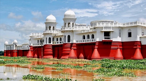
Neermahal also known as Twijilikma Nuyung () is a former royal palace of Tripura Kingdom, built by Maharaja Bir Bikram Kishore Manikya bahadur in 1930. It is also the largest water palace in India. The palace is situated in the middle of Rudrasagar Lake ( Twijilikma ), in Melaghar 53 kilometers away from Agartala, the capital of Tripura. History The ‘lake palace’ of Tripura, Neer-Mahal was constructed as a summer residence of the royal family. Maharaja Bir Bikram Kishore Manikya Debbarma, of the‘ Manikya Dynasty’, which is supposed to be the second longest remaining dynasty in the world today, built this palace in 1921. In 1921, the Maharaja commissioned the British company, Martin and Burns to build a unique water palace in the middle of Lake Rudrasagar. The lake palace was designed and built on detailed instructions from the Maharaja himself and blended Hindu and Mughal architectural styles. Marble and sandstone were used extensively and even today, the ... [...More Info...] [...Related Items...] OR: [Wikipedia] [Google] [Baidu] |
Ujjayanta Palace
Ujjayanta Palace or Nuyungma is the state museum of the Indian state of Tripura and former royal palace of the princely state of Tripura. It was built by Maharaja Radha Kishore Manikya in 1901. It housed the State Legislative Assembly between 1973 and 2011. The palace primarily showcases the lifestyle, arts, culture, tradition and crafts of communities residing in northeast India, along with many stone sculptures of the Manikya dynasty. History As royal palace The original Ujjayanta Palace was built in 1862, away from Agartala, by King Ishan Chandra Manikya (1849–1862). It was devastated by the 1897 Assam earthquake. The current palace was built in the heart of Agartala city by Maharaja Radha Kishore Manikya Maharaja Radha Kishore Manikya of the Manikya Dynasty reigned as the king of Tripura (princely state), Tripura State from 1897 to 1909. He has been described as one of the architects of modern Tripura. Administration Maharaja Radha Kishore Mani ... between 1 ... [...More Info...] [...Related Items...] OR: [Wikipedia] [Google] [Baidu] |
West Tripura
West Tripura is an administrative district in the state of Tripura in India. The district headquarters are located at Agartala. As of 2012 it is the most populous district of Tripura (out of 8). Geography Climate District profile The information provided below are taken from a book based on 2012 statistics, all the names, infos, details, etc. are in effect from and on 2012 Divisions West Tripura District has Three sub-divisions: * Mohanpur Subdivision *Jirania Subdivision * Sadar Subdivision West Tripura District has 9 Blocks: *Bamutia *Belbari *Dukli *Hezamara *Jirania *Lefunga *Mandwi *Mohanpur *Old Agartala Lok Sabha constituencies West Tripura district is located in two Lok Sabha constituencies: Tripura West (shared with South Tripura district), and Tripura East (shared with South Tripura, Dhalai and North Tripura districts). Demographics According to the 2011 census West Tripura district has a population of 1,725,739, roughly equal to the nation of The Gamb ... [...More Info...] [...Related Items...] OR: [Wikipedia] [Google] [Baidu] |
Tripura State Museum Agartala Tripura India
Tripura () is a state in northeastern India. The third-smallest state in the country, it covers ; and the seventh-least populous state with a population of 3.67 million. It is bordered by Assam and Mizoram to the east and by Bangladesh to the north, south and west. Tripura is divided into 8 districts and 23 sub-divisions, where Agartala is the capital and the largest city in the state. Tripura has 19 different tribal communities with a majority Bengali population. Bengali, English and Kokborok are the state's official languages. The area of modern Tripura — ruled for several centuries by the Manikya Dynasty — was part of the Tripuri Kingdom (also known as Hill Tippera). It became a princely state under the British Raj during its tenure, and acceded to independent India in 1947. It merged with India in 1949 and was designated as a 'Part C State' (union territory). It became a full-fledged state of India in 1972. Tripura lies in a geographically isolated location in In ... [...More Info...] [...Related Items...] OR: [Wikipedia] [Google] [Baidu] |
Mughal Empire
The Mughal Empire was an Early modern period, early modern empire in South Asia. At its peak, the empire stretched from the outer fringes of the Indus River Basin in the west, northern Afghanistan in the northwest, and Kashmir in the north, to the highlands of present-day Assam and Bangladesh in the east, and the uplands of the Deccan Plateau in South India.. Quote: "The realm so defined and governed was a vast territory of some , ranging from the frontier with Central Asia in northern Afghanistan to the northern uplands of the Deccan plateau, and from the Indus basin on the west to the Assamese highlands in the east." The Mughal Empire is conventionally said to have been founded in 1526 by Babur, a Tribal chief, chieftain from what is today Uzbekistan, who employed aid from the neighboring Safavid Iran, Safavid and Ottoman Empires Quote: "Babur then adroitly gave the Ottomans his promise not to attack them in return for their military aid, which he received in the form of the ... [...More Info...] [...Related Items...] OR: [Wikipedia] [Google] [Baidu] |
Bengal Gazetteer 1907-9
Bengal ( ) is a Historical geography, historical geographical, ethnolinguistic and cultural term referring to a region in the Eastern South Asia, eastern part of the Indian subcontinent at the apex of the Bay of Bengal. The region of Bengal proper is divided between the modern-day sovereign nation of Bangladesh and the States and union territories of India, Indian states of West Bengal, and Karimganj district of Assam. The ancient Vanga Kingdom is widely regarded as the namesake of the Bengal region. The Bengali calendar dates back to the reign of Shashanka in the 7th century CE. The Pala Empire was founded in Bengal during the 8th century. The Sena dynasty and Deva dynasty ruled between the 11th and 13th centuries. By the 14th century, Bengal was absorbed by Muslim conquests in the Indian subcontinent. An independent Bengal Sultanate was formed and became the eastern frontier of the Islamic world. During this period, Bengal's rule and influence spread to Assam, Arakan, Tri ... [...More Info...] [...Related Items...] OR: [Wikipedia] [Google] [Baidu] |


