|
Early Cretaceous
The Early Cretaceous (geochronology, geochronological name) or the Lower Cretaceous (chronostratigraphy, chronostratigraphic name) is the earlier or lower of the two major divisions of the Cretaceous. It is usually considered to stretch from 143.1 Megaannum#SI prefix multipliers, Ma to 100.5 Ma. Geology Proposals for the exact age of the Barremian–Aptian boundary ranged from 126 to 117 Ma until recently (as of 2019), but based on drillholes in Svalbard the defining Anoxic event#Cretaceous, early Aptian Oceanic Anoxic Event 1a (OAE1a) was dated to 123.1±0.3 Ma, limiting the possible range for the boundary to c. 122–121 Ma. There is a possible link between this anoxic event and a series of Early Cretaceous large igneous provinces (LIP). The Ontong Java Plateau, Ontong Java-Manihiki Plateau, Manihiki-Hikurangi Plateau, Hikurangi large igneous province, emplaced in the South Pacific at c. 120 Ma, is by far the largest LIP in Earth's history. The Onto ... [...More Info...] [...Related Items...] OR: [Wikipedia] [Google] [Baidu] |
International Commission On Stratigraphy
The International Commission on Stratigraphy (ICS), sometimes unofficially referred to as the International Stratigraphic Commission, is a daughter or major subcommittee grade scientific organization that concerns itself with stratigraphy, stratigraphical, geology, geological, and chronology, geochronological matters, worldwide. It is the largest subordinate body of the International Union of Geological Sciences (IUGS). The ICS is essentially a permanent working committee, working subcommittee, which meets far more regularly than the quadrennial meetings scheduled by the IUGS, when it meets as a congress or committee, membership of the whole. Aims One of its main aims, a project begun in 1974, is to establish a multidisciplinary standard and global geologic time scale that will ease paleontology, paleontological and geobiology, geobiological comparisons region to region by benchmarks with stringent and rigorous strata criteria called Global Boundary Stratotype Section and Points ... [...More Info...] [...Related Items...] OR: [Wikipedia] [Google] [Baidu] |
Large Igneous Province
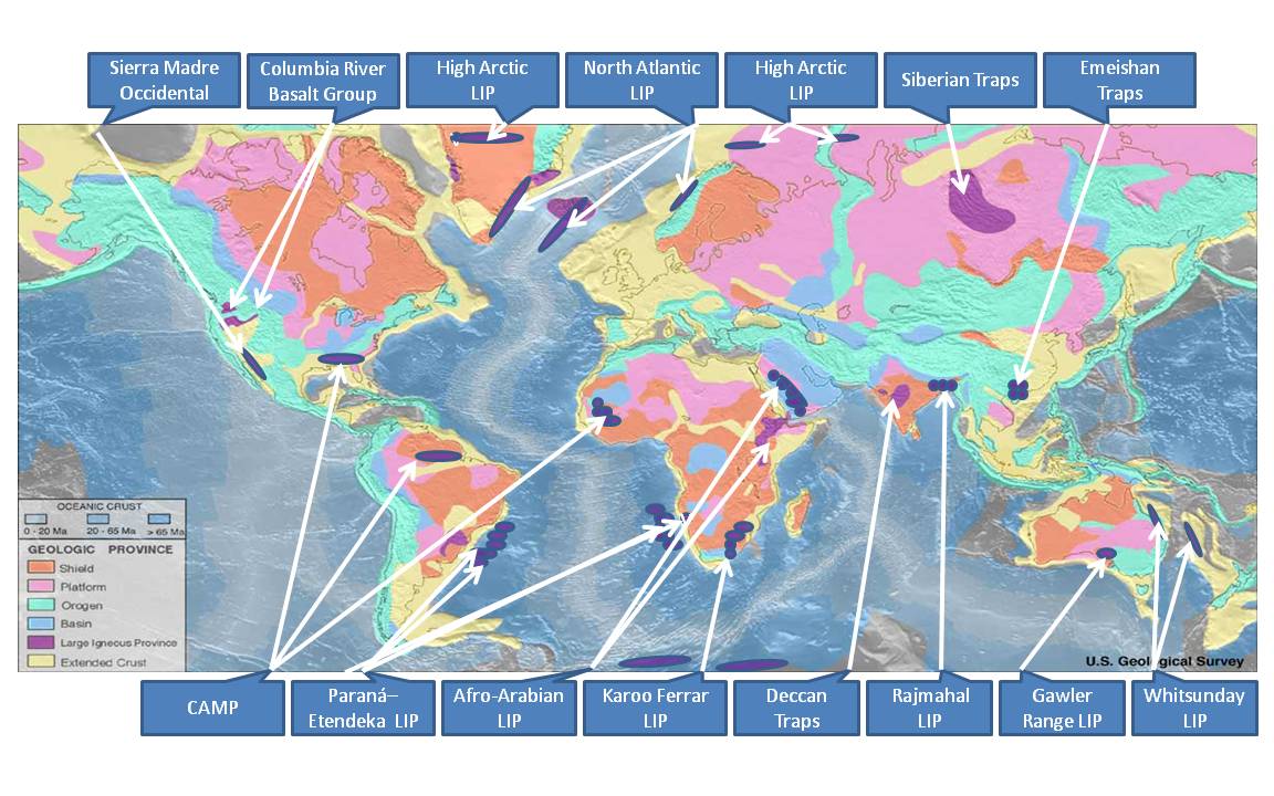
A large igneous province (LIP) is an extremely large accumulation of igneous rocks, including intrusive ( sills, dikes) and extrusive (lava flows, tephra deposits), arising when magma travels through the crust towards the surface. The formation of LIPs is variously attributed to mantle plumes or to processes associated with divergent plate tectonics. The formation of some of the LIPs in the past 500 million years coincide in time with mass extinctions and rapid climatic changes, which has led to numerous hypotheses about causal relationships. LIPs are fundamentally different from any other currently active volcanoes or volcanic systems. Overview Definition In 1992, Coffin and Eldholm initially defined the term "large igneous province" as representing a variety of mafic igneous provinces with areal extent greater than 100,000 km2 that represented "massive crustal emplacements of predominantly mafic (magnesium- and iron-rich) extrusive and intrusive rock, and origin ... [...More Info...] [...Related Items...] OR: [Wikipedia] [Google] [Baidu] |
Mid-Atlantic Ridge
The Mid-Atlantic Ridge is a mid-ocean ridge (a Divergent boundary, divergent or constructive Plate tectonics, plate boundary) located along the floor of the Atlantic Ocean, and part of the List of longest mountain chains on Earth, longest mountain range in the world. In the North Atlantic, the ridge separates the North American plate, North American from the Eurasian plate and the African plate, north and south of the Azores triple junction. In the South Atlantic, it separates the African plate, African and South American plate, South American plates. The ridge extends from a junction with the Gakkel Ridge (Mid-Arctic Ridge) northeast of Greenland southward to the Bouvet triple junction in the South Atlantic. Although the Mid-Atlantic Ridge is mostly an underwater feature, portions of it have enough elevation to extend above sea level, for example in Iceland. The ridge has an average spreading rate of about per year. Discovery A ridge under the northern Atlantic Ocean was first ... [...More Info...] [...Related Items...] OR: [Wikipedia] [Google] [Baidu] |
Rhyolite
Rhyolite ( ) is the most silica-rich of volcanic rocks. It is generally glassy or fine-grained (aphanitic) in texture (geology), texture, but may be porphyritic, containing larger mineral crystals (phenocrysts) in an otherwise fine-grained matrix (geology), groundmass. The mineral assemblage is predominantly quartz, sanidine, and plagioclase. It is the extrusive equivalent of granite. Its high silica content makes rhyolitic magma extremely viscosity, viscous. This favors explosive eruptions over effusive eruptions, so this type of magma is more often erupted as pyroclastic rock than as lava flows. Rhyolitic ash-flow tuffs are among the most voluminous of continental igneous rock formations. Rhyolitic tuff has been used extensively for construction. Obsidian, which is rhyolitic volcanic glass, has been used for tools from prehistoric times to the present day because it can be shaped to an extremely sharp edge. Rhyolitic pumice finds use as an abrasive, in concrete, and as a soil ... [...More Info...] [...Related Items...] OR: [Wikipedia] [Google] [Baidu] |
Basalt
Basalt (; ) is an aphanite, aphanitic (fine-grained) extrusive igneous rock formed from the rapid cooling of low-viscosity lava rich in magnesium and iron (mafic lava) exposed at or very near the planetary surface, surface of a terrestrial planet, rocky planet or natural satellite, moon. More than 90% of all volcanic rock on Earth is basalt. Rapid-cooling, fine-grained basalt is chemically equivalent to slow-cooling, coarse-grained gabbro. The eruption of basalt lava is observed by geologists at about 20 volcanoes per year. Basalt is also an important rock type on other planetary bodies in the Solar System. For example, the bulk of the plains of volcanism on Venus, Venus, which cover ~80% of the surface, are basaltic; the lunar mare, lunar maria are plains of flood-basaltic lava flows; and basalt is a common rock on the surface of Mars. Molten basalt lava has a low viscosity due to its relatively low silica content (between 45% and 52%), resulting in rapidly moving lava flo ... [...More Info...] [...Related Items...] OR: [Wikipedia] [Google] [Baidu] |
Paraná And Etendeka Traps
The Paraná-Etendeka Large Igneous Province (PE-LIP) (or Paraná and Etendeka Plateau; or Paraná and Etendeka Province) is a large igneous province that includes both the main Paraná traps (in Paraná Basin, a South American geological basin) as well as the smaller severed portions of the flood basalts at the Etendeka traps (in northwest Namibia and southwest Angola). The original basalt flows occurred 136 to 132 million years ago. The province had a post-flow surface area of and an original volume projected to be in excess of 2.3 million km3. Geodynamics The basalt samples at Paraná and Etendeka have an age of about 132 Ma, during the Valanginian stage of the Early Cretaceous. Indirectly, the rifting and extension are probably the origin of the Paraná and Etendeka traps and it could be the origin of the Gough and Tristan da Cunha Islands as well, as they are connected by the Walvis Ridge (Gough/ Tristan hotspot). The seamounts of the Rio Grande Rise (25°S to 3 ... [...More Info...] [...Related Items...] OR: [Wikipedia] [Google] [Baidu] |
Superplume
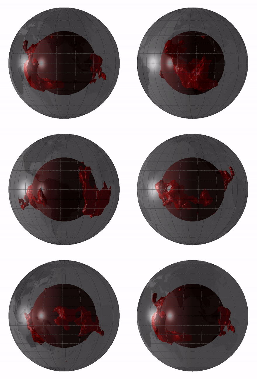
Large low-shear-velocity provinces (LLSVPs), also called large low-velocity provinces (LLVPs) or superplumes, are characteristic structures of parts of the lowermost mantle, the region surrounding the outer core deep inside the Earth. These provinces are characterized by slow shear wave velocities and were discovered by seismic tomography of deep Earth. There are two main provinces: the African LLSVP and the Pacific LLSVP, both extending laterally for thousands of kilometers and possibly up to 1,000 kilometres vertically from the core–mantle boundary. These have been named Tuzo and Jason respectively, after Tuzo Wilson and W. Jason Morgan, two geologists acclaimed in the field of plate tectonics. The Pacific LLSVP is across and underlies four hotspots on Earth's crust that suggest multiple mantle plumes underneath. These zones represent around 8% of the volume of the mantle, or 6% of the entire Earth. Other names for LLSVPs and their superstructures include superswells, ... [...More Info...] [...Related Items...] OR: [Wikipedia] [Google] [Baidu] |
Liaodong Peninsula
The Liaodong or Liaotung Peninsula ( zh, s=辽东半岛, t=遼東半島, p=Liáodōng Bàndǎo) is a peninsula in southern Liaoning province in Northeast China, and makes up the southwestern coastal half of the Liaodong region. It is located between the mouths of the Daliao River (the historical lower section of the Liao River) in the west and the Yalu River in the east, and encompasses the territories of the whole sub-provincial city of Dalian and parts of prefectural cities of Yingkou, Anshan and Dandong. The word "Liaodong" literally means "Liao region's east", referring initially to the Warring States period Yan commandery of Liaodong, which encompassed an area from modern Liaoning-Jilin border in the north to the Chongchon River on the Korean Peninsula in the south, and from just east of the Qian Mountains to a now-disappeared large wetland between the western banks of middle Liao River and the base of Yiwulü Mountain, historically known as the "Liao Mire" ( ... [...More Info...] [...Related Items...] OR: [Wikipedia] [Google] [Baidu] |
Broken Ridge
The Broken Ridge or Broken Plateau is an oceanic plateau in the south-eastern Indian Ocean. The Broken Ridge once formed a large igneous province (LIP) together with the Kerguelen Plateau. When Australia and Antarctica started to separate, the Broken Ridge and the Kerguelen Plateau got separated by the Southeast Indian Ridge. Alkalic basalt from the Broken Ridge has been dated to 95 Ma. The Broken Ridge stretches from the southern end of the Ninety East Ridge towards the south-western corner of Australia. It is up to wide and reaches below sea level. It is separated from the Diamantina fracture zone on its southern side by a escarpment, while on the northern side the ridge slopes gently towards the abyssal Wharton Basin. The sediment cover on the ridge reaches and the Moho is found at about . It is separated from the Naturaliste Plateau by the Dirck Hartog Ridge. The Kerguelen LIP covered making it the second largest LIP on Earth (after the Ontong Java Plateau ... [...More Info...] [...Related Items...] OR: [Wikipedia] [Google] [Baidu] |
Kerguelen Plateau
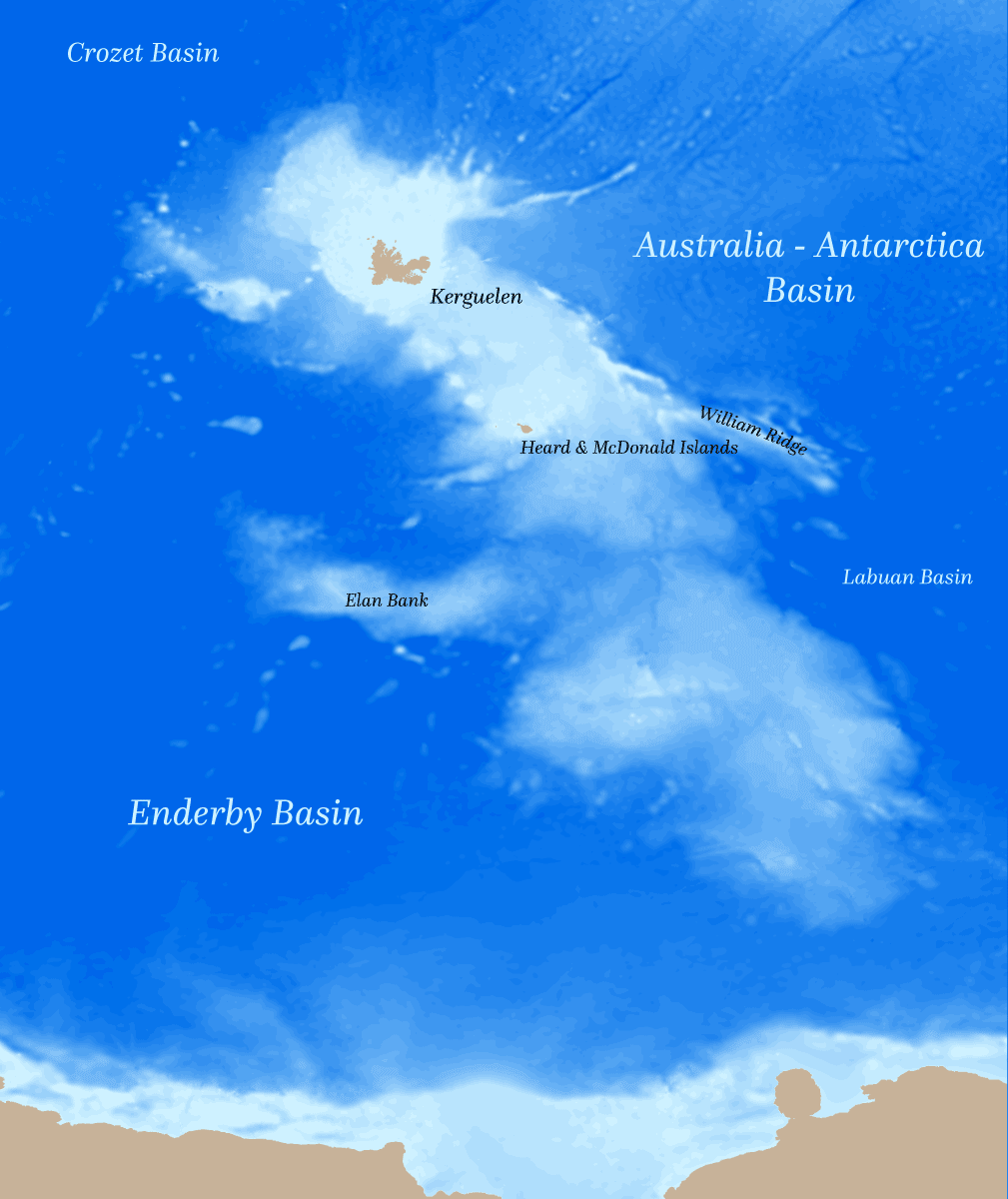
The Kerguelen Plateau (, ), also known as the Kerguelen–Heard Plateau, is an oceanic plateau and large igneous province (LIP) located on the Antarctic Plate, in the southern Indian Ocean. It is about to the southwest of Australia and is nearly three times the size of California. The plateau extends for more than in a northwest–southeast direction and lies in deep water. The plateau was produced by the Kerguelen hotspot, starting with or following the breakup of Gondwana about 130 million years ago. A small portion of the plateau breaks sea level, forming the Kerguelen Islands (a overseas territory (France), French overseas territory) plus the Heard Island and McDonald Islands, Heard and McDonald Islands (an states and territories of Australia, Australian external territory). Intermittent volcanism continues on the Heard and McDonald Islands. Geographical extent Symmetrically across the Indian Ocean ridge and due west of Australia is the Broken Ridge underwater volcanic ... [...More Info...] [...Related Items...] OR: [Wikipedia] [Google] [Baidu] |


