|
Concepción De Ataco
Concepción de Ataco is a district and city within the Ahuachapán Department, El Salvador. It has an area of 61.03 km ² and a population of 18,101 inhabitants (est. 2006). The district is divided into 11 cantons, which are: El Arco, El Limo, El Naranjito, El Tronconal, La Ceiba, La Joya de los Apante, La Planxa, San Jose, Shucutitán and Texusín Chirizo. Atacos's population has pre-Columbian origin and was founded by Yaqui Indians or pipiles in central Apaneca Mountain Range. In Nawat, Ataco means "high place of springs.” Concepción de Ataco's "sister city" is Elk Grove, California. Ataco also shares a sister city relationship with Fountain Hills, Arizona. History According to Archbishop Pedro Cortes y Larraz, Ataco in 1770 belonged to the parish of Ahuachapán. Its population consisted of 303 families with 784 indigenous people who spoke the Nahuat language of the Pipil people, they also spoke and understood Spanish. In the colonial period Ataco belonged to the ... [...More Info...] [...Related Items...] OR: [Wikipedia] [Google] [Baidu] |
Departments Of El Salvador
El Salvador is divided into 14 departments (Spanish: ''departamentos'') for administrative purposes, subdivided into 44 Municipalities of El Salvador, municipalities (''municipios'') and 262 districts. The country is a unitary state. History June 12, 1824: The first Salvadoran constitution within the Federal Republic of Central America establishes a territorial division of four departments, Sonsonate, San Salvador, San Vicente, and San Miguel. Sonsonate was formerly part of Guatemala before this point. 1833-1834: A short lived Department of Tejutla was established from the districts of Metapán and Tejutla in San Salvador. January 22, 1835: The Federal District of San Salvador is separated both from San Salvador department and from the State of Salvador. The remainder of San Salvador department is renamed to Cuscatlan, and Metapan district is transferred to Sonsonate department. May 17, 1839: Cuscatlán's Olocuitla district and San Vicente's Zacatecoluca district are combin ... [...More Info...] [...Related Items...] OR: [Wikipedia] [Google] [Baidu] |
Iglesia Ave Maria Ataco
Iglesia may refer to: * Iglesia, the Spanish form of church * Iglesia Department * Iglesia ni Cristo * Iglesia Filipina Independiente The Philippine Independent Church (; ), officially referred to by its Philippine Spanish name (IFI) and colloquially called the Aglipayan Church, is an Independent Catholic, independent catholic Christian denomination, in the form of a Religi ... * Iglesia (Metro Madrid), a station on Line 1 {{disambiguation ... [...More Info...] [...Related Items...] OR: [Wikipedia] [Google] [Baidu] |
El Pital
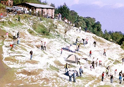
Cerro El Pital is a mountain in Central America, on the border of El Salvador and Honduras. It is located from the town of La Palma at a height of above sea level, and is the highest point in Salvadoran territory and the third from Honduras. Cerro El Pital is in the middle of a cloud forest that has an average annual temperature of . It is one of the most popular tourist draws in El Salvador, with great biodiversity in a wide altitudinal range containing many endangered species of flora and fauna. The cloud forest has some of the rarest plants and animals in the country, including quetzals and other endangered species. From November to February the temperature ranges between and (lowest recorded, in January 1956) and in the rest of the year the temperature ranges between and . It is the coldest place in El Salvador El Salvador, officially the Republic of El Salvador, is a country in Central America. It is bordered on the northeast by Honduras, on the northwest by Guat ... [...More Info...] [...Related Items...] OR: [Wikipedia] [Google] [Baidu] |
San Salvador
San Salvador () is the Capital city, capital and the largest city of El Salvador and its San Salvador Department, eponymous department. It is the country's largest agglomeration, serving as the country's political, cultural, educational and financial center. The Municipalities of El Salvador, municipality of San Salvador has 525,990 inhabitants (2024). The Metropolitan Area of San Salvador, which comprises the capital itself and 13 of its municipalities, has a population of 2,404,097. The urban area of San Salvador has a population of 1,600,000 inhabitants. The city is home to the ''Consejo de Ministros de El Salvador'' (Council of Ministries of El Salvador), the Legislative Assembly of El Salvador, the Supreme Court of El Salvador, and other governmental institutions, as well as the official residence of the president of El Salvador. San Salvador is located in the Salvadoran highlands, surrounded by volcanoes and prone to earthquakes. The city is also home to the Roman Catholic ... [...More Info...] [...Related Items...] OR: [Wikipedia] [Google] [Baidu] |
Apaneca
Apaneca is a district in the Ahuachapán department of El Salvador. It has an area of 45.13 square kilometers. Its population is of 8,597 inhabitants (Estimated 2006). The municipality is divided in 7 cantons: *El Saltillal *Palo Verde *Quezalapa *San Ramoncito *Taltapanca *Tizapa *Tulapa Towns * Santa Leticia See also * Concepcion de Ataco *La Palma La Palma (, ), also known as ''La isla bonita'' () and historically San Miguel de La Palma, is the most northwesterly island of the Canary Islands, a Spanish autonomous community and archipelago in Macaronesia in the North Atlantic Ocean. La Pa ... * Antiguo Cuscatlan * Ahuachapan, El Salvador {{commonscat, Apaneca Municipalities of the Ahuachapán Department ... [...More Info...] [...Related Items...] OR: [Wikipedia] [Google] [Baidu] |
Santa Ana, El Salvador
Santa Ana () is the second largest city in El Salvador, after the capital of San Salvador. It is located 64 kilometers northwest of San Salvador, the capital city. Santa Ana has approximately 250,760 (2024) inhabitants and serves both as the capital of the Departments of El Salvador, department of Santa Ana Department, Santa Ana and as the municipal seat for the surrounding municipality of the same name. For its administration the municipality is divided into 35 colonias (neighborhoods) and 318 small villages. A major processing center for El Salvador's sizable coffee bean industry is located near Santa Ana. Santa Ana has become a tourist destination, especially for tourists eager to learn about Salvadoran culture and traditions. Currently, the mayor of Santa Ana is Gustavo Acevedo, from Nuevas Ideas. Geography The city of Santa Ana is located on a plateau about 665 meters above sea level. The city has year-round warm climate with an average temperature of around . The mai ... [...More Info...] [...Related Items...] OR: [Wikipedia] [Google] [Baidu] |
Pan-American Highway
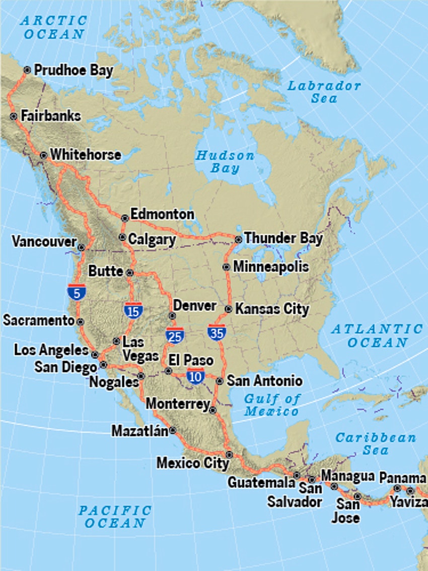
The Pan-American Highway is a vast network of roads that stretches about 30,000 kilometers (about 19,000 miles) from Prudhoe Bay, Alaska, in the northernmost part of North America to Ushuaia, Argentina, at the southern tip of South America. It is recognized as the longest road in the world. The highway connects 14 countries, including Canada, the United States, Mexico, Guatemala, El Salvador, Honduras, Nicaragua, Costa Rica, Panama, Colombia, Ecuador, Peru, Chile, and Argentina. No road in the U.S. or Canada is officially designated as part of the Pan-American Highway, which officially begins at the U.S.-Mexico border in Nuevo Laredo and runs south. The highway is interrupted at the Darién Gap, a dense rainforest area between Panama and Colombia. No road traverses the Gap, and no car ferries have operated in the area for decades; drivers often opt to send their car by cargo ship from one country to the other. Concept of the highway The highway was built in stages. The fir ... [...More Info...] [...Related Items...] OR: [Wikipedia] [Google] [Baidu] |
Panamericana Oeste To Ahuachapan - By SCP
The Pan-American Highway is a vast network of roads that stretches about 30,000 kilometers (about 19,000 miles) from Prudhoe Bay, Alaska, in the northernmost part of North America to Ushuaia, Argentina, at the southern tip of South America. It is recognized as the longest road in the world. The highway connects 14 countries, including Canada, the United States, Mexico, Guatemala, El Salvador, Honduras, Nicaragua, Costa Rica, Panama, Colombia, Ecuador, Peru, Chile, and Argentina. No road in the U.S. or Canada is officially designated as part of the Pan-American Highway, which officially begins at the U.S.-Mexico border in Nuevo Laredo and runs south. The highway is interrupted at the Darién Gap, a dense rainforest area between Panama and Colombia. No road traverses the Gap, and no car ferries have operated in the area for decades; drivers often opt to send their car by cargo ship from one country to the other. Concept of the highway The highway was built in stages. The fir ... [...More Info...] [...Related Items...] OR: [Wikipedia] [Google] [Baidu] |


