|
Chupungnyeong
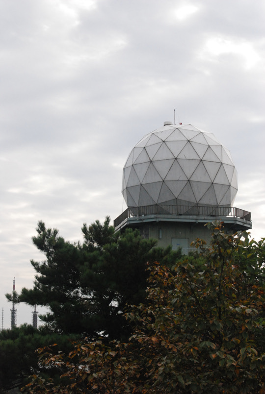
Chupungnyeong is a mountain pass between Yeongdong-gun, Chungcheongbuk-do and Gimcheon-si, Gyeongsangbuk-do in South Korea. Summary It lies in the Sobaek Mountains, and it was a border between Jinhan and Mahan in Proto–Three Kingdoms period and Silla and Baekje in Three Kingdoms period. Now it is a border between Chungcheongbuk-do and Gyeongsangbuk-do, Hoseo and Yeongnam. Korail Gyeongbu Line, Route 4 and Gyeongbu Expressway pass through it, and it is the highest point in Gyeongbu Line. There is a meteorological observatory controlled by Daejeon Area Meteorological Administration. As a name of administrative divisions, it is one of myeon in Yeongdong-gun and ri in Chupungnyeong-myeon. Around * Gyeongbu Line – Chupungnyeong station * Gyeongbu Expressway Chupungnyeong IC/SA * Chupungnyeong Meteorological Observatory Climate Chupungnyeong has a humid continental climate (Köppen climate classification The Köppen climate classification divides Earth climates in ... [...More Info...] [...Related Items...] OR: [Wikipedia] [Google] [Baidu] |
Chupungnyeong Station
Chupungnyeong station () is a railway station on the Gyeongbu Line in Yeongdong County, Yeongdong, South Korea. There is an historic water tower at the station from 1939 that supplied steam engine trains. References Railway stations in North Chungcheong Province {{SouthKorea-railstation-stub ... [...More Info...] [...Related Items...] OR: [Wikipedia] [Google] [Baidu] |
Gyeongbu Expressway
The Gyeongbu Expressway (; Asian Highway Network ) is the second oldest and most heavily travelled expressway in South Korea, connecting Seoul to Suwon, Daejeon, Gumi, South Korea, Gumi, Daegu, Gyeongju, Ulsan and Busan. It has the route number 1, signifying its role as South Korea's most important expressway. The entire length from Seoul to Busan is and the posted speed limit is , enforced primarily by speed cameras. History Inspired by the Autobahn during a trip to Germany, President of South Korea, South Korean President Park Chung Hee proposed the construction of the Gyeongbu Expressway as an election pledge in 1967. * February 1968 - Construction begins at the behest of South Korean President Park Chung Hee, who named Park Myung-keun in charge of construction. * 21 December 1968 - Seoul-Suwon segment opens to traffic. * 30 December 1968 - Suwon-Osan segment opens to traffic. * 29 September 1969 - Anseong-Cheonan segment opens to traffic. * 10 December 1969 - Cheonan-Da ... [...More Info...] [...Related Items...] OR: [Wikipedia] [Google] [Baidu] |
Gyeongbu Line
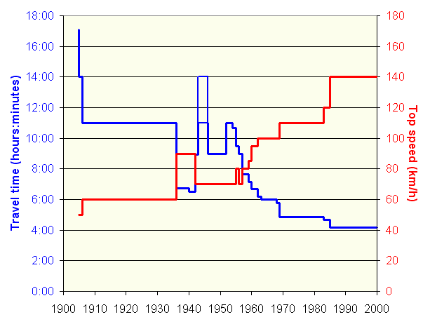
The Gyeongbu line (''Gyeongbuseon'') is a railway line in South Korea and is considered to be the most important and one of the oldest in the country. It was constructed in 1905, connecting Seoul with Busan via Suwon, Daejeon, and Daegu. It is by far the most heavily travelled rail line in South Korea. All types of Korea Train Express, high-speed, express, local, and freight trains provide frequent service along its entire length. History In 1894–1895, the Empire of Japan and Qing Dynasty, Qing China fought the First Sino-Japanese War for influence over Korea. Following the war, Japan competed with the Russian Empire's railway expansion in Northeast Asia, which led it to seek the right from the Korean Empire to build a railway from Busan to Keijō. This railway line was intended by Japan to solidify its strategic positions against Russia, which it would later go to Russo-Japanese War, war. Surveying began in 1896, and in spite of local protests, the Korean Empire gave Jap ... [...More Info...] [...Related Items...] OR: [Wikipedia] [Google] [Baidu] |
Yeongdong-gun
Yeongdong County () is a county in North Chungcheong Province, South Korea. The county should not be confused with the similarly named Yeongdong region. During the Korean War, this county was the site of the No Gun Ri Massacre. Climate Yeongdong has a humid continental climate (Köppen: ''Dwa''), but can be considered a borderline humid subtropical climate (Köppen: ''Cwa'') using the isotherm. Tourist spot 8 Scenic Sites of Hancheon * Wollyu-bong * Sanyang-byeok * Cheonghak-gul * Yongyeon-dae * Naengcheon-jeong * Beopjon-am * Sagung-bong * Hwaeon-ak Twin towns – sister cities Yeongdong is twinned with: Domestic * Seodaemun-gu, Seoul * Yongsan-gu, Seoul * Gangnam-gu, Seoul * Osan, Gyeonggi International * Fangchenggang, Guangxi, China * Dumaguete, Philippines * Alameda, United States of America See also *Geography of South Korea South Korea is located in East Asia, on the southern portion of the Korean Peninsula located out from the far east of the Asian lan ... [...More Info...] [...Related Items...] OR: [Wikipedia] [Google] [Baidu] |
Mountain Pass
A mountain pass is a navigable route through a mountain range or over a ridge. Since mountain ranges can present formidable barriers to travel, passes have played a key role in trade, war, and both Human migration, human and animal migration throughout history. At lower elevations it may be called a hill pass. A mountain pass is typically formed between two volcanic peaks or created by erosion from water or wind. Overview Mountain passes make use of a gap (landform), gap, saddle (landform), saddle, col or notch (landform), notch. A topographic saddle is analogous to the mathematical concept of a saddle surface, with a saddle point marking the minimum high point between two valleys and the lowest point along a ridge. On a topographic map, passes can be identified by contour lines with an hourglass shape, which indicates a low spot between two higher points. In the high mountains, a difference of between the summit and the mountain is defined as a mountain pass. Passes are o ... [...More Info...] [...Related Items...] OR: [Wikipedia] [Google] [Baidu] |
Landforms Of North Gyeongsang Province
A landform is a land feature on the solid surface of the Earth or other planetary body. They may be natural or may be anthropogenic (caused or influenced by human activity). Landforms together make up a given terrain, and their arrangement in the landscape is known as topography. Landforms include hills, mountains, canyons, and valleys, as well as shoreline features such as bays, peninsulas, and seas, including submerged features such as mid-ocean ridges, volcanoes, and the great oceanic basins. Physical characteristics Landforms are categorized by characteristic physical attributes such as elevation, slope, orientation, structure stratification, rock exposure, and soil type. Gross physical features or landforms include intuitive elements such as berms, cliffs, hills, mounds, peninsulas, ridges, rivers, valleys, volcanoes, and numerous other structural and size-scaled (e.g. ponds vs. lakes, hills vs. mountains) elements including various kinds of inland and oceanic waterbodi ... [...More Info...] [...Related Items...] OR: [Wikipedia] [Google] [Baidu] |
Köppen Climate Classification
The Köppen climate classification divides Earth climates into five main climate groups, with each group being divided based on patterns of seasonal precipitation and temperature. The five main groups are ''A'' (tropical), ''B'' (arid), ''C'' (temperate), ''D'' (continental), and ''E'' (polar). Each group and subgroup is represented by a letter. All climates are assigned a main group (the first letter). All climates except for those in the ''E'' group are assigned a seasonal precipitation subgroup (the second letter). For example, ''Af'' indicates a tropical rainforest climate. The system assigns a temperature subgroup for all groups other than those in the ''A'' group, indicated by the third letter for climates in ''B'', ''C'', ''D'', and the second letter for climates in ''E''. Other examples include: ''Cfb'' indicating an oceanic climate with warm summers as indicated by the ending ''b.'', while ''Dwb'' indicates a semi-Monsoon continental climate, monsoonal continental climate ... [...More Info...] [...Related Items...] OR: [Wikipedia] [Google] [Baidu] |
Humid Continental Climate
A humid continental climate is a climatic region defined by Russo-German climatologist Wladimir Köppen in 1900, typified by four distinct seasons and large seasonal temperature differences, with warm to hot (and often humid) summers, and cold (sometimes severely cold in the northern areas) and snowy winters. Precipitation is usually distributed throughout the year, but often these regions do have dry seasons. The definition of this climate in terms of temperature is as follows: the mean temperature of the coldest month must be below or depending on the isotherm, and there must be at least four months whose mean temperatures are at or above . In addition, the location in question must not be semi-arid or arid. The cooler ''Dfb'', ''Dwb'', and ''Dsb'' subtypes are also known as hemiboreal climates. Although amount of snowfall is not a factor used in defining the humid continental climate, snow during the winter in this type of climate is almost a guarantee, either intermitte ... [...More Info...] [...Related Items...] OR: [Wikipedia] [Google] [Baidu] |
Myeon (administrative Division)
A ''myeon'', ''myŏn'', ''myon'', or township () is an administrative unit in South Korea similar to the unit of town. Along with town, township is of a county and some cities of fewer than 500,000 population. ''Myeon'' have smaller populations than towns and represent the rural areas of a county or city. Townships are subdivided into villages. The minimum population limit is 6,000. See also *Administrative divisions of South Korea South Korea is made up of 22 first-tier administrative divisions: 6 List of special cities of South Korea#Position in hierarchy and types, metropolitan cities (''gwangyeoksi'' ), 1 List of special cities of South Korea, special city (''teukbyeo ... References {{SouthKorea-geo-stub ... [...More Info...] [...Related Items...] OR: [Wikipedia] [Google] [Baidu] |
Administrative Divisions Of South Korea
South Korea is made up of 22 first-tier administrative divisions: 6 List of special cities of South Korea#Position in hierarchy and types, metropolitan cities (''gwangyeoksi'' ), 1 List of special cities of South Korea, special city (''teukbyeolsi'' ), 1 List of special cities of South Korea#Position in hierarchy and types, special self-governing city (''teukbyeol-jachisi'' ), and Provinces of South Korea, 14 provinces (''Do (province), do'' ), including three Provinces of South Korea#Types, special self-governing provinces (''teukbyeol jachido'' ) and Provinces of North Korea, five claimed by Committee for the Five Northern Korean Provinces, the ROK government. These are further subdivided into a variety of smaller entities, including List of cities in South Korea, cities (''si'' ), List of counties in South Korea, counties (''Gun (administrative division), gun'' ), List of districts in South Korea, districts (''Gu (administrative division), gu'' ), List of towns in South Korea, ... [...More Info...] [...Related Items...] OR: [Wikipedia] [Google] [Baidu] |
Korea Meteorological Administration
The Korea Meteorological Administration (KMA; ) is the national meteorological service of South Korea. The service started in 1904 joining the WMO in 1956. Numerical weather prediction is performed using the Unified Model software suite. History The current administration was established in 1990. Temporary observatories set up in 1904 in Busan, Incheon, Mokpo and elsewhere were precursors to the current KMA. The Central Meteorological Office (CMO) was established in August 1949. In April 1978, CMO was renamed the Korea Meteorological Service (KMS). In 1999, the administration introduced a meteorological supercomputer for forecasting. As of November 2021, supercomputers ''Guru'' and ''Maru'' ranked 27th and 28th respectively TOP500, in the world. In 2010, the KMA launched South Korea’s first geostationary meteorological satellite, the Communication, Ocean and Meteorological Satellite (COMS), also known as Chollian. Chollian started its official operation in 2011. The Seoul and ... [...More Info...] [...Related Items...] OR: [Wikipedia] [Google] [Baidu] |


