|
Ch'eqofo River
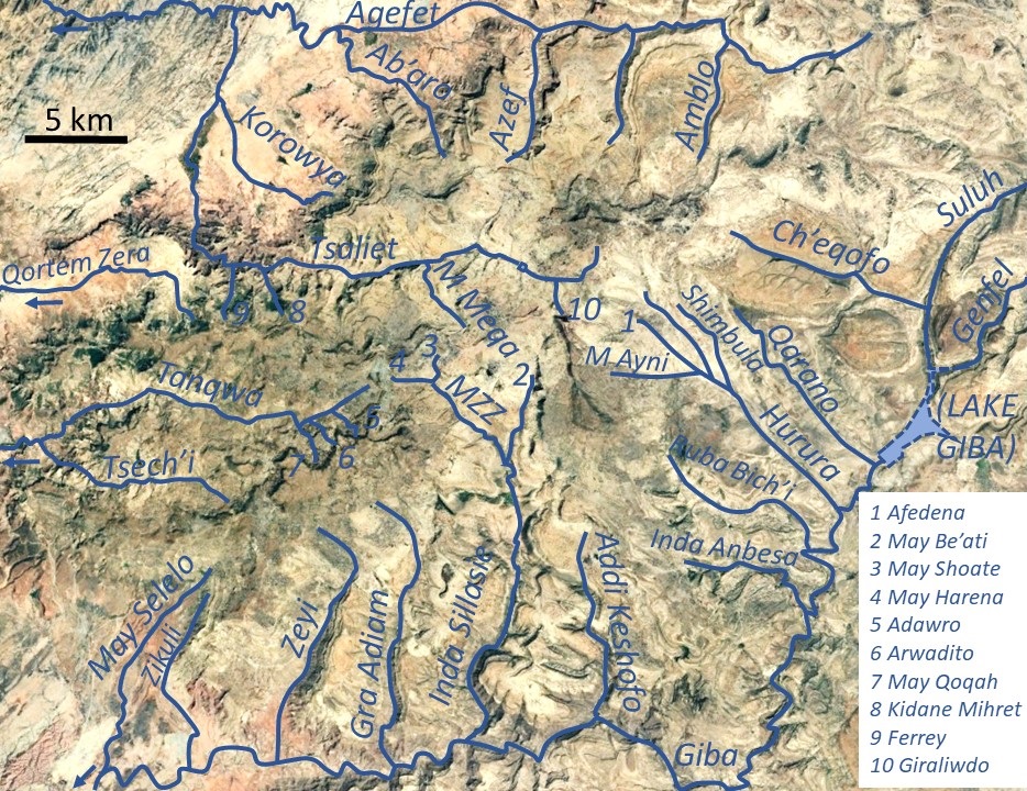
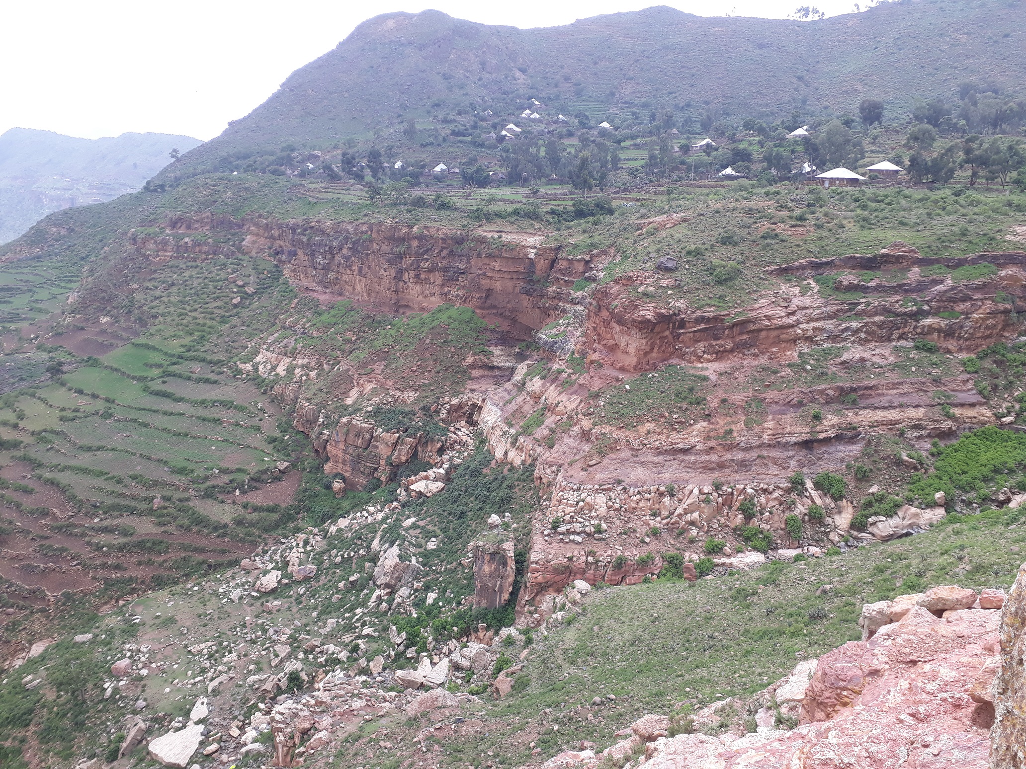
Ch’eqofo is a river of the Nile basin. Rising in the mountains of Dogu’a Tembien in northern Ethiopia, it flows southwestward to empty finally in Giba and Tekezé River. Characteristics It is a confined ephemeral river, locally meandering in its narrow alluvial plain, with an average slope gradient of 39 metres per kilometre. With its tributaries, the river has cut a deep gorge. Flash floods and flood buffering Runoff mostly happens in the form of high runoff discharge events that occur in a very short period (called flash floods). These are related to the steep topography, often little vegetation cover and intense convective rainfall. The peaks of such flash floods have often a 50 to 100 times larger discharge than the preceding baseflow. The magnitude of floods in this river has however been decreased due to interventions in the catchment. On steep slopes, exclosures have been established; the dense vegetation largely contributes to enhanced infiltration, less flooding ... [...More Info...] [...Related Items...] OR: [Wikipedia] [Google] [Baidu] |
Degua Tembien
Dogu'a Tembien (, "Upper Tembien", sometimes transliterated as Degua Tembien) is a woreda in Tigray Region, Ethiopia. It is named in part after the former province of Tembien. Nowadays, the mountainous district is part of the Southeastern Tigray Zone. The administrative centre of this woreda is Hagere Selam. History Dogu’a Tembien holds numerous prehistoric sites, which have been dated to the Middle Stone Age in Ayninbirkekin, or Pastoral Neolithic in Aregen and Menachek. Geography Topography and landscapes Major mountains :* Tsatsen, 2815 metres, a wide mesa between Hagere Selam and Inda Maryam Qorar () :* Ekli Imba, 2799 metres, summit of the Arebay massif in Arebay ''tabia'' or district () :* Imba Zuw’ala, 2710 metres, near Hagere Selam () :* Aregen, 2660 metres, in Aregen ''tabia'' () :* Dabba Selama, 2630 metres, in Haddinnet ''tabia'' () (not to be confused with the homonymous monastery) :* Imba Dogu’a, 2610 metres, in Mizane Birhan ''tabia'' () :* I ... [...More Info...] [...Related Items...] OR: [Wikipedia] [Google] [Baidu] |
Terrace (earthworks)
In agriculture, a terrace is a piece of sloped plane that has been cut into a series of successively receding flat surfaces or platforms, which resemble steps, for the purposes of more effective farming. This type of landscaping is therefore called terracing. Graduated terrace steps are commonly used to farm on hilly or mountainous terrain. Terraced fields decrease both erosion and surface runoff, and may be used to support growing crops that require irrigation, such as rice. The Rice Terraces of the Philippine Cordilleras have been designated as a UNESCO World Heritage Site because of the significance of this technique. Uses Terraced paddy fields are used widely in rice, wheat and barley farming in east, south, southwest, and southeast Asia, as well as the Mediterranean Basin, Africa, and South America. Drier-climate terrace farming is common throughout the Mediterranean Basin, where they are used for vineyards, olive trees, cork oak, and other crops. Ancient history ... [...More Info...] [...Related Items...] OR: [Wikipedia] [Google] [Baidu] |
Rivers Of Ethiopia
This is a list of streams and rivers in Ethiopia, arranged geographically by drainage basin. There is an alphabetic list at the end of this article. Flowing into the Mediterranean *''Nile (Egypt, Sudan)'' Atbarah River * Mareb River (or Gash River) (only reaches the Atbarah in times of flood) ** Obel River * Tekezé River (or Takkaze or Setit) **Zarima River ** Ataba River ** Wari River *** Qortem Zer'a *** Tsaliet **** Agefet ***** Ab'aro ***** Azef River ***** Amblo **** Korowya **** Ferrey River **** Kidane Mihret River **** May Meqa **** Graliwdo ** Giba River *** Tanqwa **** Tsech'i River **** May Qoqah **** Arwadito **** Adawro River *** May Selelo *** Zikuli River *** Gra Adiam River, also called Bitchoqo River *** Zeyi River *** Inda Sillasie River **** May Zegzeg ***** May Harena ***** May Sho'ate **** May Be'ati River *** Addi Keshofo River *** May Gabat *** Inda Anbesa *** Ruba Bich'i River *** Hurura **** Afedena River ***** May Ay ... [...More Info...] [...Related Items...] OR: [Wikipedia] [Google] [Baidu] |
Transhumance In Ethiopia
Transhumance is a type of pastoralism or nomadism, a seasonal movement of livestock between fixed summer and winter pastures. In montane regions (''vertical transhumance''), it implies movement between higher pastures in summer and lower valleys in winter. Herders have a permanent home, typically in valleys. Generally only the herds travel, with a certain number of people necessary to tend them, while the main population stays at the base. In contrast, ''horizontal transhumance'' is more susceptible to being disrupted by climatic, economic, or political change. Traditional or fixed transhumance has occurred throughout the inhabited world, particularly Europe and western Asia. It is often important to pastoralist societies, as the dairy products of transhumance flocks and herds (milk, butter, yogurt and cheese) may form much of the diet of such populations. In many languages there are words for the higher summer pastures, and frequently these words have been used as place names ... [...More Info...] [...Related Items...] OR: [Wikipedia] [Google] [Baidu] |
Tufa
Tufa is a variety of limestone formed when carbonate minerals precipitate out of water in unheated rivers or lakes. Geothermally heated hot springs sometimes produce similar (but less porous) carbonate deposits, which are known as travertine. Tufa is sometimes referred to as (meteogene) travertine. It should not be confused with hot spring (thermogene) travertine. Tufa, which is calcareous, should also not be confused with tuff, a porous volcanic rock with a similar etymology that is sometimes also called "tufa". Classification and features Modern and fossil tufa deposits abound with wetland plants; as such, many tufa deposits are characterised by their large macrobiological component, and are highly porous. Tufa forms either in fluvial channels or in lacustrine environments. Ford and Pedley (1996) provide a review of tufa systems worldwide. Fluvial deposits Deposits can be classified by their depositional environment (or otherwise by vegetation or petrographically). P ... [...More Info...] [...Related Items...] OR: [Wikipedia] [Google] [Baidu] |
Quaternary
The Quaternary ( ) is the current and most recent of the three period (geology), periods of the Cenozoic era (geology), Era in the geologic time scale of the International Commission on Stratigraphy (ICS). It follows the Neogene Period and spans from 2.58 million years ago to the present. The Quaternary Period is divided into two epochs: the Pleistocene (2.58 million years ago to 11.7 thousand years ago) and the Holocene (11.7 thousand years ago to today, although a third epoch, the Anthropocene, has been proposed but is not yet officially recognised by the ICS). The Quaternary Period is typically defined by the cyclic growth and decay of continental ice sheets related to the Milankovitch cycles and the associated climate and environmental changes that they caused. Research history In 1759 Giovanni Arduino (geologist), Giovanni Arduino proposed that the geological strata of northern Italy could be divided into four successive formations or "orders" ( it, quattro ord ... [...More Info...] [...Related Items...] OR: [Wikipedia] [Google] [Baidu] |
Antalo Limestone
The Antalo Limestone, also known as the Antalo Sequence, is a geological formation in Ethiopia. It is between 300 and 800 metres thick and comprises fossiliferous limestones and marls that were deposited in a reef. Marine microfossils have shown an age between 165 and 150 million years. Name and definition The Antalo Supersequence includes two main stratigraphic units: the Antalo Sequence and the Agula Group. The Antalo Sequence, or Antalo Limestone has been named after the town of Hintalo in Tigray, Ethiopia. The name of the formation was coined by geologist William Thomas Blanford, who accompanied the British Expedition to Abyssinia in 1868. At that time, Hintalo was a major town on the route of the invading British army. So far the nomenclature has not been proposed for recognition to the International Commission on Stratigraphy. Geographical extent The sedimentary succession is found in Ethiopia, in the Mekelle Outlier, in the Blue Nile gorge, in the Harrar Plateau an ... [...More Info...] [...Related Items...] OR: [Wikipedia] [Google] [Baidu] |
Dolerite
Diabase (), also called dolerite () or microgabbro, is a mafic, holocrystalline, subvolcanic rock equivalent to volcanic basalt or plutonic gabbro. Diabase dikes and sills are typically shallow intrusive bodies and often exhibit fine-grained to aphanitic chilled margins which may contain tachylite (dark mafic glass). ''Diabase'' is the preferred name in North America, while ''dolerite'' is the preferred name in the rest of the English-speaking world, where sometimes the name ''diabase'' refers to altered dolerites and basalts. Some geologists prefer to avoid confusion by using the name ''microgabbro''. The name ''diabase'' comes from the French ', and ultimately from the Greek - meaning "act of crossing over, transition". Petrography Diabase normally has a fine but visible texture of euhedral lath-shaped plagioclase crystals (62%) set in a finer matrix of clinopyroxene, typically augite (20–29%), with minor olivine (3% up to 12% in olivine diabase), magnetite (2%), and i ... [...More Info...] [...Related Items...] OR: [Wikipedia] [Google] [Baidu] |
Amba Aradam Formation
The Amba Aradam Formation is a Cretaceous sandstone formation in Ethiopia. It is up to 200 metres thick, for instance in the Degua Tembien district. As fossils are absent, the age of the Amba Aradam Formation was interpreted based on the age of assumed corresponding sandstones elsewhere in Ethiopia: the Debre Libanos Sandstones in the Blue Nile Basin, and the Upper Sandstone near Harrar in southeast Ethiopia, both of Late Cretaceous age (100–66 million years ago). The lithology of the Amba Aradam Formation makes it less suitable for rock church excavation; caves have however been blasted in this formation to serve as headquarters for the TPLF during the Ethiopian Civil War of the 1980s. Name and definition The name “Amba Aradam Sandstone” was coined by geologist William Thomas Blanford, who accompanied the British invading army in 1868. The formation is named after the Amba Aradam mountain, where the formation widely outcrops. So far the nomenclature was not proposed for ... [...More Info...] [...Related Items...] OR: [Wikipedia] [Google] [Baidu] |
Ashangi Basalts
The Ashangi Basalts are the earliest Tertiary volcanic rocks in north Ethiopia, hence they are in the lowest position. These dark porphyritic basalts are separated from the Mesozoic formations below it by basal conglomerates. The basalts hold phenocrysts that developed before the magma reached the earth surface. These basalts are weathered, partially eroded and have a sub-horizontal stratification, particularly at the lower part. This series was created during the first period of the flood basalt eruptions in north Ethiopia, in the Oligocene. Name and definition The name was coined by geologist William Thomas Blanford, who accompanied the British Expedition to Abyssinia in 1868,{{cite book , last1=Blanford , first1=W.T. , title=Observations on the geology and zoology of Abyssinia, made during the progress of the British expedition to that country in 1867-68 , url=https://archive.org/details/cu31924024736666 , date=1870 , publisher=Macmillan and Co. , location=London after Lake Ha ... [...More Info...] [...Related Items...] OR: [Wikipedia] [Google] [Baidu] |
Check Dam
A steel check dam A check dam is a small, sometimes temporary, dam constructed across a swale, drainage ditch, or waterway to counteract erosion by reducing water flow velocity. Check dams themselves are not a type of new technology; rather, they are an ancient technique dating from the second century A.D. Check dams are typically, though not always, implemented in a system of several dams situated at regular intervals across the area of interest. Function A check dam placed in the ditch, swale, or channel interrupts the flow of water and flattens the gradient of the channel, thereby reducing the velocity. In turn, this obstruction induces infiltration and reduces eroding. They can be used not only to slow flow velocity but also to distribute flows across a swale to avoid preferential paths and guide flows toward vegetation. Although some sedimentation may result behind the dam, check dams do not primarily function as sediment-trapping devices. For instance, on the Gra ... [...More Info...] [...Related Items...] OR: [Wikipedia] [Google] [Baidu] |


