|
Boeotia
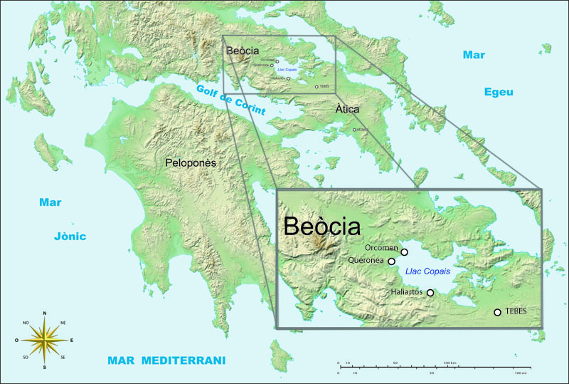
Boeotia ( ), sometimes Latinisation of names, Latinized as Boiotia or Beotia (; modern Greek, modern: ; ancient Greek, ancient: ), is one of the regional units of Greece. It is part of the modern regions of Greece, region of Central Greece (administrative region), Central Greece. Its capital is Livadeia, and its largest city is Thebes, Greece, Thebes. Boeotia was also a region of ancient Greece, from before the 6th century BC. Geography Boeotia lies to the north of the eastern part of the Gulf of Corinth. It also has a short coastline on the Gulf of Euboea. It bordered on Megaris (now West Attica) in the south, Attica in the southeast, Euboea in the northeast, Opuntian Locris (now part of Phthiotis) in the north and Phocis in the west. The main mountain ranges of Boeotia are Mount Parnassus in the west, Mount Helicon in the southwest, Cithaeron in the south and Parnitha in the east. Its longest river, the Cephissus (Boeotia), Cephissus, flows in the central part, where most of ... [...More Info...] [...Related Items...] OR: [Wikipedia] [Google] [Baidu] |
Thebes, Greece
Thebes ( ; , ''Thíva'' ; , ''Thêbai'' .) is a city in Boeotia, Central Greece (administrative region), Central Greece, and is one of the oldest continuously inhabited cities in the world. It is the largest city in Boeotia and a major center for the area along with Livadeia and Tanagra. It played an important role in Greek myths, as the site of the stories of Cadmus, Oedipus, Dionysus, Heracles and others. One myth had the city founded by Agenor, which gave rise to the (now somewhat obscure) name "Agenorids" to denote Thebans. Archaeological excavations in and around Thebes have revealed a Mycenaean Greece, Mycenaean settlement and clay tablets written in the Linear B script, indicating the importance of the site in the Bronze Age. Thebes was the largest city of the ancient region of Boeotia and was the leader of the Boeotian confederacy. It was a major rival of Classical Athens, ancient Athens, and sided with the Achaemenid Empire, Persians during the Second Persian invasi ... [...More Info...] [...Related Items...] OR: [Wikipedia] [Google] [Baidu] |
Orchomenus (Boeotia)
Orchomenus ( ''Orchomenos''), the setting for many early Greek mythology, Greek myths, is best known today as a rich archaeological site in Boeotia, Greece, that was inhabited from the Neolithic through the Hellenistic periods. It is often referred to as "Minyans, Minyan Orchomenus", to distinguish it from a later Orchomenus (Arcadia), city of the same name in Arcadia (region), Arcadia. Ancient history According to the founding myth of Orchomenos, its royal dynasty was established by the Minyans, who had followed their eponymous leader Minyas (mythology), Minyas from coastal Thessaly to settle the site. In the Bronze Age, during the fourteenth and thirteenth centuries BC, Orchomenos became a rich and important centre of civilisation in Mycenaean Greece and a rival to Thebes, Greece, Thebes. The palace with its frescoed walls and the great beehive tomb show the power of Orchomenos in Mycenaean Greece. A massive hydraulic undertaking drained the marshes of Lake Copais, Lake Kopa ... [...More Info...] [...Related Items...] OR: [Wikipedia] [Google] [Baidu] |
Livadeia
Livadeia ( ''Livadiá'', ; or , ''Lebadia'') is a town in central Greece. It is the capital of the Boeotia Regional units of Greece, regional district. Livadeia lies north-west of Athens, west of Chalkida, south-east of Lamia (city), Lamia, east-south-east of Amfissa, and east-north-east of Nafpaktos. The town lies some west of Greek National Road 3, to which it is linked by Greek National Road 48, National Road 48. The area around Livadeia is mountainous, with farming activities mainly confined to the valleys. The area has traditionally been associated with the production and processing of cotton and tobacco, as well as the cultivation of cereal crops and the raising of livestock. The city also known for having participated in the Trojan War in allegiance with Mycenae. Livadeia is home to Levadiakos F.C., it currently plays in the Superleague Greece, Greek Superleague. Geography The municipality of Livadeia covers an area of , the municipal unit of Livadeia and the comm ... [...More Info...] [...Related Items...] OR: [Wikipedia] [Google] [Baidu] |
Lake Copais
Lake Copais, also spelled Kopais or Kopaida (; ), was a lake in the centre of Boeotia, Greece, west of Thebes. It was first drained in the Bronze Age, and drained again in the late 19th century. It is now flat dry land and is still known as Kopaida. A one-time island in the lake was modified in ancient times into a megalithic citadel, now called Gla. Lake Copais is also featured in Ubisoft's Assassin's Creed Odyssey (2018). Drainage When the lake existed, the towns of Haliartus, Orchomenus, and Chaeronea were on its shores. Rivers feeding the lake included the Cephissus, Termessus and Triton. The lake was (and is) surrounded by fertile land, but the lake increasingly encroached on the surrounding land because of inadequate drainage. First, though abortive, plans to drain the lake were made in 1834-1838. In 1865 a French company, Montferrier and Bonnair, signed a contract with the Greek government to drain the lake. But in 1873 after having drained the lake partially, th ... [...More Info...] [...Related Items...] OR: [Wikipedia] [Google] [Baidu] |
Minyans
In Greek mythology, the Minyans or Minyae ( Greek: Μινύες, ''Minyes'') were a group of legendary people who were the inhabitants of the city Orchomenus in Boeotia, and who were also associated with Thessaly. They were named after their eponymous ancestor, Minyas. In archaeology, the term "Minyans" has been applied to the Minyan ware excavated from Orchomenus, and is used to refer to an autochthonous group of Proto-Greek speakers inhabiting the Aegean region, though the degree to which the material culture in the prehistory of the area can be securely linked to the legendary people or language-based ethnicity has been subjected to debate and repeated revision. John L. Caskey's interpretation of his archaeological excavations conducted in the 1950s linked the ethno-linguistic " Proto-Greeks" to the bearers of the Minyan (or Middle Helladic) culture. More recent scholars have questioned or amended his dating and doubted the linking of material culture to linguistic ... [...More Info...] [...Related Items...] OR: [Wikipedia] [Google] [Baidu] |
Cephissus (Boeotia)
The Cephissus (), called the Boeotian Cephissus to distinguish it from other rivers of the same name, or Kifisos () is a river in central Greece. Its drainage basin is . The river rises at Lilaia in Phocis, on the northwestern slope of Mount Parnassus. It flows east through the Boeotian plain, passing the towns Amfikleia, Kato Tithorea and Orchomenos. It drained into Lake Copais, which was therefore also called the Cephisian Lake, until 1887, when the lake was eliminated in favor of agricultural land. An artificial outflow has been created to Lake Yliki (ancient Hylice), further east. Hydrology The Cephisus, a post-glacial river, never had sufficient flow deriving from drainage to establish a clear channel to the Gulf of Euboea. Its main flow was seasonal melt water, which collected in a three-lake system in the lowlands of Boeotia. First it entered Lake Copais, which was never more than a wetland a few feet deep. Today it has been totally drained for agriculture, reveal ... [...More Info...] [...Related Items...] OR: [Wikipedia] [Google] [Baidu] |
Opuntian Locris
Opuntian Locris or Eastern Locris was an ancient Greece, ancient Greek region inhabited by the eastern division of the Locrians, the so-called tribe of the Locri Epicnemidii () or Locri Opuntii (Greek: ). Geography Opuntian Locris consisted of a narrow slip upon the eastern coast of central Greece, from the pass of Thermopylae to the mouth of the river Cephissus (Boeotia), Cephissus. The northern frontier town was Alpeni, which bordered upon the Malians (Greek tribe), Malians, and the southern frontier town was Larymna, which at a later time belonged to Boeotia. The Locrians, however, did not inhabit this coast continuously, but were separated by a narrow slip of Phocis, which extended to the North Euboean Gulf, and contained the Phocian seaport town of Daphnus. The Locrians north of Daphnus were called ''Epicnemidii'', from Mount Cnemis; and those south of this town were named ''Opuntii'', from Opus, Greece, Opus, their principal city. On the west, the Locrians were separated f ... [...More Info...] [...Related Items...] OR: [Wikipedia] [Google] [Baidu] |
Ancient Greece
Ancient Greece () was a northeastern Mediterranean civilization, existing from the Greek Dark Ages of the 12th–9th centuries BC to the end of classical antiquity (), that comprised a loose collection of culturally and linguistically related city-states and communities. Prior to the Roman period, most of these regions were officially unified only once under the Kingdom of Macedon from 338 to 323 BC. In Western history, the era of classical antiquity was immediately followed by the Early Middle Ages and the Byzantine period. Three centuries after the decline of Mycenaean Greece during the Bronze Age collapse, Greek urban poleis began to form in the 8th century BC, ushering in the Archaic period and the colonization of the Mediterranean Basin. This was followed by the age of Classical Greece, from the Greco-Persian Wars to the death of Alexander the Great in 323 BC, and which included the Golden Age of Athens and the Peloponnesian War. The u ... [...More Info...] [...Related Items...] OR: [Wikipedia] [Google] [Baidu] |
Lake Yliki
Lake Yliki ( ''Yliki'', Ancient Greek: Ὑλίκη ''Hylike'', Latinised as ''Hylica'') is a large natural lake of Boeotia, central Greece. Situated 8 km north of Thebes at 78 m elevation, it has been an important source of drinking water for the Athens agglomeration since 1958. It is surrounded by low mountains, which separate it from the drained Lake Copais. Wildlife The lake is home to several threatened endemic or near-endemic fish species: (IUCN Red List The International Union for Conservation of Nature (IUCN) Red List of Threatened Species, also known as the IUCN Red List or Red Data Book, founded in 1964, is an inventory of the global conservation status and extinction risk of biological ... status shown) *Yliki barbel or ('' Barbus carottae'') formerly classified as ('' Luciobarbus graecus'') *Greek stickleback or ('' Pungitius hellenicus'') *marathon minnow ('' Pelasgus marathonicus'') *Beotian riffle dace or ('' Telestes beoticus'') *Greek rudd or ('' ... [...More Info...] [...Related Items...] OR: [Wikipedia] [Google] [Baidu] |
Cithaeron
Cithaeron or Kithairon (Κιθαιρών, -ῶνος) is a mountain and mountain range about sixteen kilometres (ten miles) long in Central Greece (geographic region), Central Greece. The range is the physical boundary between Boeotia region in the north and Attica region in the south. It is mainly composed of limestone and rises to . The north-east side of the range is formed by the mountain Pastra (mountain), Pastra. The range was the scene of many events in Greek mythology and was especially sacred to Dionysus. In Euripides' ''Bacchae'', Dionysus carries out his dances and rites with his bacchants, his priestesses, on Cithaeron. Oedipus was exposed on the mountain, while Actaeon and Pentheus were both dismembered on its slopes. It was also the place where Heracles or Alcathous of Elis, Alcathous hunted and killed the Lion of Cithaeron. In historic times, the mountain acted as a backdrop to the Battle of Plataea of 479 BC and was the scene of much skirmishing before the battle ... [...More Info...] [...Related Items...] OR: [Wikipedia] [Google] [Baidu] |
Mount Helicon
Mount Helicon (; ) is a mountain in the region of Thespiai in Boeotia, Greece, celebrated in Greek mythology. With an altitude of , it is located approximately from the north coast of the Gulf of Corinth. Some researchers maintain that Helicon was also the Greek name of mount Rocca Salvatesta in Sicily as a river started from it was called also Helikon. Greek mythology In Greek mythology, two springs sacred to the Muses were located here: the Aganippe and the Hippocrene, both of which bear "horse" (ἵππος ''híppos'') in their names. In a related myth, the Hippocrene spring was created when the winged horse Pegasus aimed his hoof at a rock, striking it with such force that the spring burst from the spot. On Mount Helicon too was the spring where Narcissus was inspired by his own beauty. Mount Helicon and the Hippocrene spring were considered to be a source of poetic inspiration. In the late eighth or early seventh century BCE, the poet Hesiod placed a reference to the M ... [...More Info...] [...Related Items...] OR: [Wikipedia] [Google] [Baidu] |


