|
Adelsö
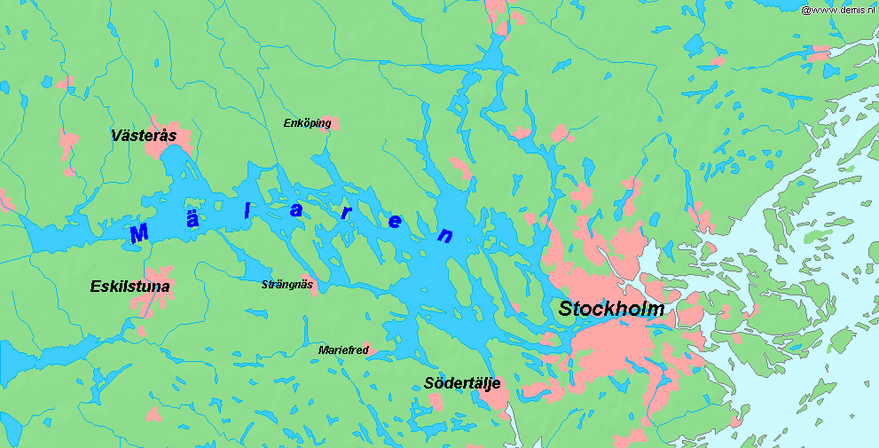
Adelsö is an island in the middle of Lake Mälaren in Sweden, near Björkfjärden. The island is part of Ekerö Municipality and Stockholm County. It is about by ferry and road west of downtown Stockholm. The administrative center of the important Viking settlement Birka (on the neighbouring island Björkö) was situated at Hovgården on Adelsö. The road network is connected via a ferry link across a narrow strait to the main island of Ekerö. Geography The Adelsö landscape consists of pine-clad rocky hills and moraine ridges dotted with fields and deciduous trees, mainly oak. The highest spot on Adelsö is Kunsta Mountain, which is 53.2 m above sea level. The top of Kunsta has an outlook tower offering a great view of the middle of Lake Mälaren. There are many edible mushrooms and fruit that can be found on Adelsö including chanterelles, black trumpet, blue berries, lingonberries, juniper berries, cherries, apples, and pears. Climate Adelsö has a mixture between a ... [...More Info...] [...Related Items...] OR: [Wikipedia] [Google] [Baidu] |
Hovgården
Hovgården is an archaeological site on the Lake Mälaren island of Adelsö in Ekerö Municipality in central-eastern Sweden. During the Viking Age, the centre of the prospering Mälaren Valley was the settlement Birka, founded in the mid-8th century and abandoned in the late 10th century and located on the island Björkö just south of Adelsö. Hovgården is believed to have been the site from which kings and chieftains ruled the area. Hovgården, together with Birka became a UNESCO World Heritage Site in 1993.National Heritage Board Hovgården is located on the flat country north-west of the Romanesque Adelsö Church, characterised by a narrow rift valley stretching north to forest-laden moraines. These historical meadows lands were cultivated in the 19th century and have hardly been altered since, as several well-preserved 18th century farmyards bear witness to.Bratt History The oldest archaeological remains on Adelsö, found north of Hovgården, are grave fields and ... [...More Info...] [...Related Items...] OR: [Wikipedia] [Google] [Baidu] |
Cable Ferry
A cable ferry (including the types chain ferry, swing ferry, floating bridge, or punt) is a ferry that is guided (and in many cases propelled) across a river or large body of water by cables connected to both shores. Early cable ferries often used either rope or steel chains, with the latter resulting in the alternative name of chain ferry. Both of these were largely replaced by wire cable by the late 19th century. Types Cable ferries can be typified by their size and construction, their usage (passenger, animal, vehicle) and requirements (length of crossing, amount of other shipping), their cables (wire rope, chain, or both), and their propulsion (water current, engine, manual). The choice of cable depends partially on the requirements of the crossing but also on the historical context. For example, the numerous cable ferries across Australian and Canadian rivers seem to use wire rope exclusively, whereas the older crossings across busy tidal rivers in England all use chain. ... [...More Info...] [...Related Items...] OR: [Wikipedia] [Google] [Baidu] |
Ekerö Municipality
Ekerö Municipality () is a municipalities of Sweden, municipality in the Provinces of Sweden, province of Uppland in Stockholm County in east central Sweden. The name derives from the name of the main island within the municipality whose name is Ekerön, and literally means "Oak Island". Its seat is located in the town of Ekerö. Carl XVI Gustaf of Sweden, The King of Sweden resides in Ekerö Municipality, at Drottningholm Palace (see below). Originally, when the first local government acts were implemented in Sweden in 1863, eight rural municipalities were created, each corresponding to an old parish. The municipal reform of 1952 grouped them in two new larger entities. The next reform in 1971 merged them into the present municipality. Geography Ekerö is the only municipality in the Mälaren, Lake Mälaren region composed exclusively of islands. Post-glacial rebound, Land elevation has reduced the number of islands and Skerry, skerries to 140, the largest of which are Adels� ... [...More Info...] [...Related Items...] OR: [Wikipedia] [Google] [Baidu] |
Mälaren
Mälaren ( , , or ), historically referred to as Lake Malar in English, is the third-largest freshwater lake in Sweden (after Vänern and Vättern). Its area is and its greatest depth is 64 m (210 ft). Mälaren spans from east to west. The lake drains, from south-west to north-east, into the Baltic Sea through its natural outlets Norrström and Söderström (as it flows around Stadsholmen island) and through the artificial Södertälje Canal and Hammarbyleden waterway. The easternmost bay of Mälaren, in central Stockholm, is called Riddarfjärden. The lake is located in Svealand and bounded by the provinces of Uppland, Södermanland and Västmanland. The two largest islands in Mälaren are Selaön () and Svartsjölandet (). Mälaren is low-lying and mostly relatively shallow. Being a quite narrow and shallow lake, Mälaren has bridge crossings between Eskilstuna and Västerås with two crossings on the western end at Kvicksund and three separate bridges between St ... [...More Info...] [...Related Items...] OR: [Wikipedia] [Google] [Baidu] |
Birka
Birka (''Birca'' in medieval sources), on the island of Björkö, Ekerö, Björkö (lit. "Birch Island") in present-day Sweden, was an important Viking Age trading center which handled goods from Scandinavia as well as many parts of Continental Europe and the Orient. Björkö is located in Mälaren, Lake Mälaren, 30 kilometers west of contemporary Stockholm, in the municipality of Ekerö. Birka was founded around AD 750 and it flourished for more than 200 years. It was abandoned c. AD 975, around the same time Sigtuna was founded as a Christianity, Christian town some 35 km to the northeast. It has been estimated that the population in Viking Age Birka was between 500 and 1000 people. The archaeological sites of Birka and Hovgården, on the neighbouring island of Adelsö, make up an archaeological complex which illustrates the elaborate trading networks of Viking Scandinavia and their Viking expansion, influence on the subsequent history of Europe. Generally regarded ... [...More Info...] [...Related Items...] OR: [Wikipedia] [Google] [Baidu] |
Stone Age
The Stone Age was a broad prehistory, prehistoric period during which Rock (geology), stone was widely used to make stone tools with an edge, a point, or a percussion surface. The period lasted for roughly 3.4 million years and ended between 4000 Anno Domini, BC and 2000 BC, with the advent of metalworking. It therefore represents nearly 99.3% of human history. Though some simple metalworking of malleable metals, particularly the use of Goldsmith, gold and Coppersmith, copper for purposes of ornamentation, was known in the Stone Age, it is the melting and smelting of copper that marks the end of the Stone Age. In Western Asia, this occurred by about 3000 BC, when bronze became widespread. The term Bronze Age is used to describe the period that followed the Stone Age, as well as to describe cultures that had developed techniques and technologies for working copper alloys (bronze: originally copper and arsenic, later copper and tin) into tools, supplanting ston ... [...More Info...] [...Related Items...] OR: [Wikipedia] [Google] [Baidu] |
Seasonal Lag
Seasonal lag is the phenomenon whereby the date of maximum average air temperature at a geographical location on a planet is delayed until some time after the date of maximum daylight (i.e. the summer solstice). This also applies to the minimum temperature being delayed until some time after the date of minimum insolation. Cultural seasons are often aligned with annual temperature cycles, especially in the agrarian context. Peak agricultural growth often depends on both insolation levels and soil/air temperature. Rainfall patterns are also tied to temperature cycles, with warmer air able to hold more water vapor than cold air. In most Northern Hemisphere regions, the month of February is usually colder than the month of November despite February having significantly later sunsets and more daylight overall. Conversely, the month of August is usually hotter than the month of May despite August having later sunrises, increasingly earlier sunsets, and less daylight overall. The f ... [...More Info...] [...Related Items...] OR: [Wikipedia] [Google] [Baidu] |
Munsö
Munsö is a village and a former island (the latter is also known as Munsön) in Ekerö Municipality, Stockholm County in Sweden. Because of post-glacial rebound, this island in Lake Mälaren is now connected to the island Ekerön. The village has a 12th-century round church A round church is a church with a completely circular plan, thus a rotunda in architectural terms. There are many Nordic round churches in Sweden and Denmark (notably the island of Bornholm); round churches were popular in Scandinavia in the .... . Collins Maps. Accessed August 26, 2012. References [...More Info...] [...Related Items...] OR: [Wikipedia] [Google] [Baidu] |
Freshwater
Fresh water or freshwater is any naturally occurring liquid or frozen water containing low concentrations of dissolved salts and other total dissolved solids. The term excludes seawater and brackish water, but it does include non-salty mineral-rich waters, such as chalybeate springs. Fresh water may encompass frozen and meltwater in ice sheets, ice caps, glaciers, snowfields and icebergs, natural precipitations such as rainfall, snowfall, hail/ sleet and graupel, and surface runoffs that form inland bodies of water such as wetlands, ponds, lakes, rivers, streams, as well as groundwater contained in aquifers, subterranean rivers and lakes. Water is critical to the survival of all living organisms. Many organisms can thrive on salt water, but the great majority of vascular plants and most insects, amphibians, reptiles, mammals and birds need fresh water to survive. Fresh water is the water resource that is of the most and immediate use to humans. Fresh water is n ... [...More Info...] [...Related Items...] OR: [Wikipedia] [Google] [Baidu] |


