|
Aberffraw
Aberffraw is a village and community (Wales), community on the south west coast of the Isle of Anglesey in Wales. The village is 9 miles from the island's county town, Llangefni, and is on the west bank of the Afon Ffraw (Ffraw River). The community includes Soar, Anglesey, Soar and Dothan. It is on the A4080 road, A4080 and the nearest rail station is Bodorgan railway station, Bodorgan. The village has a long history as a settlement from the Mesolithic Age. More recently, in medieval times, the site became the capital of the Kingdom of Gwynedd and a royal residence for the family of the House of Aberffraw. The name of the village is often truncated to "Berffro" in the local dialect of Welsh. Local attractions include a part of the Anglesey Coastal Path, the beach and dunes at Aberffraw bay, a lake for recreational fishing, historic churches and prehistoric burial chambers. History Aberffraw is one of the oldest Mesolithic sites from Prehistoric Wales#Mesolithic, prehistori ... [...More Info...] [...Related Items...] OR: [Wikipedia] [Google] [Baidu] |
Aberffraw Coast
Aberffraw is a village and community on the south west coast of the Isle of Anglesey in Wales. The village is 9 miles from the island's county town, Llangefni, and is on the west bank of the Afon Ffraw (Ffraw River). The community includes Soar and Dothan. It is on the A4080 and the nearest rail station is Bodorgan. The village has a long history as a settlement from the Mesolithic Age. More recently, in medieval times, the site became the capital of the Kingdom of Gwynedd and a royal residence for the family of the House of Aberffraw. The name of the village is often truncated to "Berffro" in the local dialect of Welsh. Local attractions include a part of the Anglesey Coastal Path, the beach and dunes at Aberffraw bay, a lake for recreational fishing, historic churches and prehistoric burial chambers. History Aberffraw is one of the oldest Mesolithic sites from prehistoric Wales, dating to years ago. At Aberffraw Bay is the ''Trwyn Du'' () site. The burial was discove ... [...More Info...] [...Related Items...] OR: [Wikipedia] [Google] [Baidu] |
House Of Aberffraw
The House of Aberffraw was a medieval royal court based in the village it was named after, Aberffraw, Anglesey (Wales, UK) within the borders of the then Kingdom of Gwynedd. The dynasty was founded in the 9th century by a King in Wales whose descendants founded the Welsh Royal Houses. The other medieval Welsh dynasties were the Royal Houses of Dinefwr, Mathrafal. The Royal House is deemed to be a historiographical and genealogical term historians use to illustrate the line of succession from Rhodri the Great of Wales through his eldest son Anarawd from the 870s AD. The dynasty thrived for centuries until the demise of the royal family during the 13th century. The royal house culminated in the conquest of Wales by Edward I, and the death of the last Prince, Dafydd III in 1283. The final lineal direct descendant of the House of Aberffraw was Owain Lawgoch, he died in the 14th century. Several Welsh noble families have since claimed male descent from this family. Aberffra ... [...More Info...] [...Related Items...] OR: [Wikipedia] [Google] [Baidu] |
Kingdom Of Gwynedd
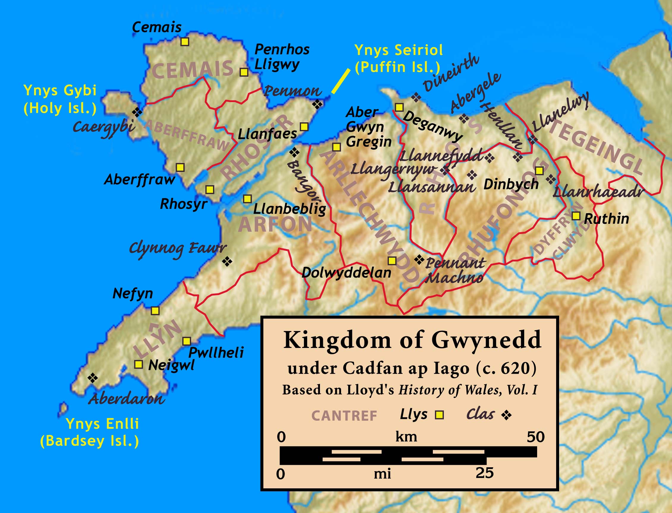
The Kingdom of Gwynedd (Medieval Latin: ; Middle Welsh: ) was a Wales in the Early Middle Ages, Welsh kingdom and a Roman Empire Succession of states, successor state that emerged in sub-Roman Britain in the 5th century during the Anglo-Saxon settlement of Britain. Based in northwest Wales, the list of rulers of Gwynedd, rulers of Gwynedd repeatedly rose to dominance and were acclaimed as "King of the Britons" before losing their power in civil wars or invasions. The kingdom of Gruffydd ap Llywelynthe King of Wales from 1055 to 1063was shattered by a Timeline of conflict in Anglo-Saxon Britain, Saxon invasion in 1063 just prior to the Norman invasion of Wales, but the House of Aberffraw restored by Gruffudd ap Cynan slowly recovered and Llywelyn the Great of Gwynedd was able to proclaim the Principality of Wales at the Aberdyfi gathering of Welsh princes in 1216. In 1277, the Treaty of Aberconwy between Edward I of England and Llywelyn's grandson Llywelyn ap Gruffudd granted pe ... [...More Info...] [...Related Items...] OR: [Wikipedia] [Google] [Baidu] |
Isle Of Anglesey
Anglesey ( ; ) is an island off the north-west coast of Wales. It forms the bulk of the Principal areas of Wales, county known as the Isle of Anglesey, which also includes Holy Island, Anglesey, Holy Island () and some islets and Skerry, skerries. The county borders Gwynedd across the Menai Strait to the southeast, and is otherwise surrounded by the Irish Sea. Holyhead is the largest town, and the administrative centre is Llangefni. The county is part of the Preserved counties of Wales, preserved county of Gwynedd. Anglesey is the northernmost county in Wales. The Isle of Anglesey has an area of and a population of in . After Holyhead (12,103), the largest settlements are Llangefni (5,500) and Amlwch (3,967). The economy of the county is mostly based on agriculture, energy, and tourism, the latter especially on the coast. Holyhead is also a major ferry port for Dublin, Ireland. The county has the second-highest percentage of Welsh language, Welsh speakers in Wales, at 57.2%, ... [...More Info...] [...Related Items...] OR: [Wikipedia] [Google] [Baidu] |
Afon Ffraw
The Afon Ffraw is a short river on the Isle of Anglesey, Wales. It arises at Llyn Coron and flows southwest for two miles along the northwestern margin of Twyn Aberffraw ('Aberffraw dunes') via the village of Aberffraw to Aberffraw Bay on the island's west coast. The river is tidal to a point just northeast of Aberffraw and is accompanied by the Wales Coast Path and Isle of Anglesey Coastal Path. Llyn Coron is fed by the Afon Gwna which rises near to Llangefni ; ) is the county town of Anglesey in Wales. At the 2011 census, Llangefni's population was 5,116, making it the second-largest town in the county and the largest on the island. The community includes the village of Rhosmeirch. Location The ... in the centre of Anglesey. The flow of the Ffraw is bolstered by the left-bank tributary, the Afon Frechwen and a larger, though unnamed right-bank tributary which rises near Gwalchmai. Pont Aberffraw is a bridge spanning the river constructed as a single stone arch in 1731 ... [...More Info...] [...Related Items...] OR: [Wikipedia] [Google] [Baidu] |
Soar, Anglesey
Soar is a village in the community of Aberffraw, Anglesey, Wales, which is 131.2 miles (211.1 km) from Cardiff and 216.3 miles (348.1 km) from London. References See also *List of localities in Wales by population The following is a list of built-up areas in Wales by population according to the 2021 and 2011 Census. 2021 This is a list of built-up areas as of the 2021 census.Within the dataset under 1d. Over 10,000 Under 10,000 2011 See also *List of ... Villages in Anglesey Biblical place-names in Wales {{Anglesey-geo-stub ... [...More Info...] [...Related Items...] OR: [Wikipedia] [Google] [Baidu] |
Prehistoric Wales
Prehistoric Wales in terms of human settlements covers the period from about 230,000 years ago, the date attributed to the earliest human remains found in what is now Wales, to the year AD 48 when the Roman army began a military campaign against one of the Welsh tribes. Traditionally, historians have believed that successive waves of immigrants brought different cultures into the area, largely replacing the previous inhabitants, with the last wave of immigrants being the Celts. However, studies of population genetics now suggest that this may not be true, and that immigration was on a smaller scale. Palaeolithic The earliest known human remains discovered in modern-day Wales date from 230,000 years ago. An early Neanderthal upper jaw fragment containing two teeth, whose owner probably lived during an interglacial period in the Lower Palaeolithic, was found in a cave in the River Elwy valley, at the Bontnewydd Palaeolithic site, near St Asaph (), Denbighshire. Excavations of ... [...More Info...] [...Related Items...] OR: [Wikipedia] [Google] [Baidu] |
A4080 Road
The A4080 is a British A road which is located on the Island of Anglesey, Wales. It follows a very roundabout route from the A5 road at Llanfairpwllgwyngyll via Newborough and Rhosneigr back to the A55 and the A5 about south of Holyhead. In all the road is about long. The route The A4080 branches off the A5 at Llanfairpwllgwyngyll, bridges the main railway line and heads south. At first it runs parallel with the Menai Strait but then moves further inland passing through the village of Brynsiencyn, where there are some sharp bends, and curving round the village of Dwyran. Another sharp bends leads to a straight section of road which passes the Anglesey Model Village. This section ends in a roundabout from which the last exit turns northwestwards and soon reaches Newborough where the B4221 branches off to the right. Passing through Newborough Forest and past Malltraeth Sands, the A4080 crosses the Afon Cefni at Malltraeth. A section of road follows with several sharp be ... [...More Info...] [...Related Items...] OR: [Wikipedia] [Google] [Baidu] |
Anglesey Coastal Path
The Anglesey Coastal Path (formally the Isle of Anglesey Coastal Path, ) is a long-distance footpath around the island of Anglesey () in North Wales. The route is part of the Wales Coast Path. Description The path mainly follows the coast. Exceptions are where the path comes inland from Moel y Don by Plas Newydd estate, and the Bodorgan Estate on the west of the island between Aberffraw and Malltraeth, where the Prince and Princess of Wales used to live. The loop officially begins and ends at Holyhead, and is described in the official guidebook in an anti-clockwise direction. It cost £1.4 million and runs virtually within the length of the entire Area of Outstanding Natural Beauty, using the existing network of public rights of way and some designated permissive paths. For example, the coastal path at Mynachdy is closed between mid-September and mid-February. There are alternatives to these permissive paths. The path is well signposted throughout. It has been walked in as ... [...More Info...] [...Related Items...] OR: [Wikipedia] [Google] [Baidu] |
Gwynedd
Gwynedd () is a county in the north-west of Wales. It borders Anglesey across the Menai Strait to the north, Conwy, Denbighshire, and Powys to the east, Ceredigion over the Dyfi estuary to the south, and the Irish Sea to the west. The city of Bangor is the largest settlement, and the administrative centre is Caernarfon. The preserved county of Gwynedd, which is used for ceremonial purposes, includes the Isle of Anglesey. Gwynedd is the second largest county in Wales but sparsely populated, with an area of and a population of 117,400. After Bangor (18,322), the largest settlements are Caernarfon (9,852), Bethesda (4,735), and Pwllheli (4,076). The county has the highest percentage of Welsh speakers in Wales, at 64.4%, and is considered a heartland of the language. The geography of Gwynedd is mountainous, with a long coastline to the west. The county contains much of Snowdonia (), a national park which contains Wales's highest mountain, Snowdon (; ). To the west, t ... [...More Info...] [...Related Items...] OR: [Wikipedia] [Google] [Baidu] |


