|
Blunsdon
Blunsdon is a civil parish in the Borough of Swindon, in Wiltshire, England, about north of the centre of Swindon, with the A419 forming its southern boundary. Its main settlement is the village of Broad Blunsdon, with Lower Blunsdon nearby; the hamlet of Broadbush is now contiguous with Broad Blunsdon. Blunsdon is the eastern half of the former Blunsdon St Andrew civil parish. In April 2017, that parish was divided and the western half became a new St Andrews parish. History Blunsdon has been inhabited at least since the Iron Age. Castle Hill is the site of a hillfort and is a scheduled monument. In Roman times, a travellers' resting place existed on the site of the present-day Cold Harbour public house. The main A419 road follow the course of a Roman road known as Ermin Way that linked the historic Roman towns of Gloucester ( Glevum) and Silchester ( Calleva Atrebatum), via Cirencester (Corinium). The Domesday Book of 1086 records a manor of ''Bluntesdone'', comprising ... [...More Info...] [...Related Items...] OR: [Wikipedia] [Google] [Baidu] |
St Andrews, Swindon
St Andrews is a civil parish in the borough of Swindon, Wiltshire, England, 3 miles north-northwest of the centre of Swindon, with the A419 forming its northeastern boundary. It is centred on the village of Blunsdon St Andrew, though much of the parish is residential, the result of urban expansion from Swindon. In 2021 it had a population of 19,096. St Andrews is the western half of the former Blunsdon St Andrew civil parish. In April 2017, that parish was divided and the eastern half became a new Blunsdon parish. History Blunsdon St Andrew is recorded in the Domesday Book of 1086 as one of three settlements in the manor of ''Bluntesdone'', in the hundred of Scipa. These settlements lay across Blunsdon Hill on either side of Ermin Way, a Roman road that linked the historic Roman towns of ''Glevum'' (Gloucester) and ''Calleva Atrebatum'' (Silchester), via ''Corinium'' (Cirencester). They were held by three different lords, though the record does not differentiate them further. ... [...More Info...] [...Related Items...] OR: [Wikipedia] [Google] [Baidu] |
Swindon North (UK Parliament Constituency)
Swindon North is a constituency represented in the House of Commons of the UK Parliament since 2024 by Will Stone, a Labour politician. Further to the completion of the 2023 Periodic Review of Westminster constituencies, the seat was formally renamed from North Swindon to Swindon North, and first contested at the 2024 general election. History North Swindon was created in 1997 and has been a bellwether since then. However, during the 2010s, the Conservatives won the constituency by much higher numbers than their national popular vote margin. Boundaries 1997–2010: The Borough of Thamesdown wards of Blunsdon, Covingham, Gorse Hill, Haydon Wick, Highworth, Moredon, St Margaret, St Philip, Western, and Whitworth, and the District of North Wiltshire ward of Cricklade. ''The seat's boundaries encompassed an area that before its creation made up parts of the former Swindon constituency and pre-1997 versions of North Wiltshire and Devizes.'' 2010–2024: The Borough of Swindo ... [...More Info...] [...Related Items...] OR: [Wikipedia] [Google] [Baidu] |
Borough Of Swindon
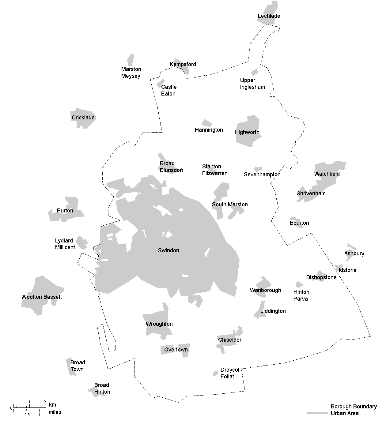
The Borough of Swindon is a unitary authority area with borough status in Wiltshire, England. Centred on Swindon, it is the most north-easterly district of South West England. History The first borough of Swindon was a municipal borough, created in 1900 as a merger of the two urban districts of Old Swindon and New Swindon. In 1974 the borough of Thamesdown was created under the Local Government Act 1972. Thamesdown covered the areas of the municipal borough of Swindon and the neighbouring Highworth Rural District (which had been created in 1894), which were both abolished at the same time. Thamesdown was a lower-tier non-metropolitan district, with Wiltshire County Council being the higher-tier authority for the area. Thamesdown was given borough status from its creation, allowing the chair of the council to take the title of mayor. On 1 April 1997 Thamesdown was made a unitary authority, making it administratively independent from Wiltshire County Council. In June 199 ... [...More Info...] [...Related Items...] OR: [Wikipedia] [Google] [Baidu] |
Highworth
Highworth is a market town and civil parish in the Borough of Swindon, England, about north-east of Swindon town centre. The 2021 Census recorded a population of 8,258. The town is notable for its Queen Anne and Georgian buildings, dating from its pre-eminence in the 18th century. It also has a 13th-century church, St. Michael and All Angels. The parish includes Sevenhampton village and the hamlets of Hampton and Redlands. History Highworth is on a hill in a strategic position above the Upper Thames Valley, and seems to have been occupied almost continuously for 7,000 years. It is mentioned in the Domesday Book as 'Wrde', which derives from the Old English word 'worth' meaning enclosure. At that time there were six households and a church. The prefix 'High', owing to it being situated on a hill, was not added until around 1200 AD. On John Speed's map of Wiltshire (1611), the name is spelt both ''Highwoth'' (for the hundred) and ''Hiworth'' (for the town itself). In 120 ... [...More Info...] [...Related Items...] OR: [Wikipedia] [Google] [Baidu] |
A419 Road
The A419 road is a primary route between Chiseldon near Swindon at junction 15 of the M4 with the A346 road, and Whitminster in Gloucestershire, England near the M5 motorway. The A419 is managed and maintained by a private company, Road Management Group, on behalf of the UK Department for Transport. Route From the M4 to Cirencester it is a dual carriageway road, which generally follows the course of the Roman road Ermin Way, but dualling work completed in the late 1990s, and the bypass of Cirencester, has taken it off-course in some places. East of Cirencester the A417 continues straight ahead as the major road and the A419 separates through Cirencester and Stroud, becoming mainly single carriageway. West of Cirencester the road loses its primary status; it crosses the M5 at junction 13 close to a former Little Chef restaurant, then finishes further west at a roundabout with the A38. A419 Road Bridge The A419 Road Bridge is a modern bridge carrying the Crick ... [...More Info...] [...Related Items...] OR: [Wikipedia] [Google] [Baidu] |
Swindon
Swindon () is a town in Wiltshire, England. At the time of the 2021 Census the population of the built-up area was 183,638, making it the largest settlement in the county. Located at the northeastern edge of the South West England region, Swindon lies on the M4 corridor, 84 miles (135 km) to the west of London and 36 miles (57 km) to the east of Bristol. The Cotswolds lie just to the town's north and the North Wessex Downs to its south. Recorded in the 1086 Domesday Book as ''Suindune'', the arrival of the Great Western Railway in 1843 transformed it from a small market town of 2,500 into a thriving railway hub that would become one of the largest Swindon Works, railway engineering complexes in the world at its peak. This brought with it pioneering amenities such as the UK's first lending library and a 'cradle-to-grave' healthcare centre that was later used as a blueprint for the NHS. Swindon's railway heritage can be primarily seen today with the grade 2 listed Railway Villag ... [...More Info...] [...Related Items...] OR: [Wikipedia] [Google] [Baidu] |
Wiltshire
Wiltshire (; abbreviated to Wilts) is a ceremonial county in South West England. It borders Gloucestershire to the north, Oxfordshire to the north-east, Berkshire to the east, Hampshire to the south-east, Dorset to the south, and Somerset to the west. The largest settlement is Swindon, and Trowbridge is the county town. The county has an area of and a population of 720,060. The county is mostly rural, and the centre and south-west are sparsely populated. After Swindon (183,638), the largest settlements are the city of Salisbury (41,820) and the towns of Chippenham (37,548) and Trowbridge (37,169). For local government purposes, the county comprises two unitary authority areas: Swindon and Wiltshire. Undulating chalk downlands characterize much of the county. In the east are Marlborough Downs, which contain Savernake Forest. To the south is the Vale of Pewsey, which separates the downs from Salisbury Plain in the centre of the county. The south-west is also downland, ... [...More Info...] [...Related Items...] OR: [Wikipedia] [Google] [Baidu] |
Manor House
A manor house was historically the main residence of the lord of the manor. The house formed the administrative centre of a manor in the European feudal system; within its great hall were usually held the lord's manorial courts, communal meals with manorial tenants and great banquets. The term is today loosely (though erroneously) applied to various English country houses, mostly at the smaller end of the spectrum, sometimes dating from the Late Middle Ages, which currently or formerly house the landed gentry. Manor houses were sometimes fortified, albeit not as fortified as castles, but this was often more for show than for defence. They existed in most European countries where feudalism was present. Function The lord of the manor may have held several properties within a county or, for example in the case of a feudal baron, spread across a kingdom, which he occupied only on occasional visits. Even so, the business of the manor was directed and controlled by regular mano ... [...More Info...] [...Related Items...] OR: [Wikipedia] [Google] [Baidu] |
Manorial System
Manorialism, also known as seigneurialism, the manor system or manorial system, was the method of land ownership (or "tenure") in parts of Europe, notably France and later England, during the Middle Ages. Its defining features included a large, sometimes fortified manor house in which the lord of the manor and his dependants lived and administered a rural estate, and a population of labourers or serfs who worked the surrounding land to support themselves and the lord. These labourers fulfilled their obligations with labour time or in-kind produce at first, and later by cash payment as commercial activity increased. Manorialism was part of the feudal system. Manorialism originated in the Roman villa system of the Late Roman Empire, and was widely practised in medieval western Europe and parts of central Europe. An essential element of feudal society, manorialism was slowly replaced by the advent of a money-based market economy and new forms of agrarian contract. Manorialism fad ... [...More Info...] [...Related Items...] OR: [Wikipedia] [Google] [Baidu] |
Feet Of Fines
A foot of fine (plural, feet of fines; Latin: ''pes finis''; plural, ''pedes finium'') is the archival copy of the agreement between two parties in an English lawsuit over land, most commonly the fictitious suit (in reality a conveyance) known as a fine of lands or final concord. The procedure was followed from around 1195 until 1833, and the considerable body of resulting records is now held at The National Archives, Kew, London. History In the reign of Henry II of England, the royal justices first began the practice of registering the settlement of disagreements over land by having both parties bring a suit before the royal courts. The resulting decision was thus given ''royal sanction''. At first, two copies of the agreement ("fine") were made, created as chirographs: i.e. the text was written in duplicate on a single piece of parchment, which was then cut in half, one copy going to each of the litigants. Under Hubert Walter's justiciarship, probably about 1195, the practice ... [...More Info...] [...Related Items...] OR: [Wikipedia] [Google] [Baidu] |
University Of Nottingham
The University of Nottingham is a public research university in Nottingham, England. It was founded as University College Nottingham in 1881, and was granted a royal charter in 1948. Nottingham's main campus (University Park Campus, Nottingham, University Park) with Jubilee Campus and teaching hospital (Queen's Medical Centre) are located within the City of Nottingham, with a number of smaller campuses and sites elsewhere in Nottinghamshire and Derbyshire. Outside the UK, the university has campuses in Semenyih, Malaysia, and Ningbo, China. Nottingham is organised into five constituent faculties, within which there are more than 50 schools, departments, institutes and research centres. Nottingham has more than 46,000 students and 7,000 staff across the UK, China and Malaysia and had an income of £834.7 million in 2023–24, of which £141.6 million was from research grants and contracts, with an expenditure of £615.3 million. The institution's alumni have been awarded one ... [...More Info...] [...Related Items...] OR: [Wikipedia] [Google] [Baidu] |
Vision Of Britain
The Great Britain Historical GIS (or GBHGIS) is a spatially enabled database that documents and visualises the changing human geography of the British Isles, although is primarily focussed on the subdivisions of the United Kingdom mainly over the 200 years since the first census in 1801. The project is currently based at the University of Portsmouth, and is the provider of the website ''A Vision of Britain through Time''. NB: A "GIS" is a geographic information system, which combines map information with statistical data to produce a visual picture of the iterations or popularity of a particular set of statistics, overlaid on a map of the geographic area of interest. Original GB Historical GIS (1994–99) The first version of the GB Historical GIS was developed at Queen Mary, University of London between 1994 and 1999, although it was originally conceived simply as a mapping extension to the existing Labour Markets Database (LMDB). The system included digital boundaries for re ... [...More Info...] [...Related Items...] OR: [Wikipedia] [Google] [Baidu] |


