|
Amlwch
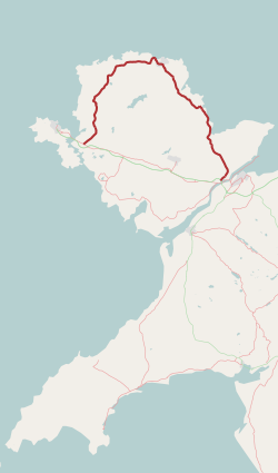
Amlwch () is a port town and community (Wales), community in Wales. It is situated on the north coast of the Anglesey, Isle of Anglesey, on the A5025 road, A5025 which connects it to Holyhead and to Menai Bridge. As well as Amlwch town and Amlwch Port, other settlements within the community include Burwen, Bull Bay, Anglesey, Bull Bay (Porthllechog) and Pentrefelin, Anglesey, Pentrefelin. The town has a beach in Llaneilian, and it has significant coastal cliffs. Tourism is an important element of the local economy. At one time it was a booming mining town that became the centre of a vast global trade in copper ore. The harbour inlet became a busy port and significant shipbuilding and ship repair centre, as well as an embarkation point with boats sailing to the Isle of Man and to Liverpool. The community covers an area of about 15 square kilometres. Town centre The name Amlwch – a reference to the site of the town's harbour, Porth Amlwch – derives from Welsh language, Welsh ... [...More Info...] [...Related Items...] OR: [Wikipedia] [Google] [Baidu] |
Anglesey
Anglesey ( ; ) is an island off the north-west coast of Wales. It forms the bulk of the Principal areas of Wales, county known as the Isle of Anglesey, which also includes Holy Island, Anglesey, Holy Island () and some islets and Skerry, skerries. The county borders Gwynedd across the Menai Strait to the southeast, and is otherwise surrounded by the Irish Sea. Holyhead is the largest town, and the administrative centre is Llangefni. The county is part of the Preserved counties of Wales, preserved county of Gwynedd. Anglesey is the northernmost county in Wales. The Isle of Anglesey has an area of and a population of in . After Holyhead (12,103), the largest settlements are Llangefni (5,500) and Amlwch (3,967). The economy of the county is mostly based on agriculture, energy, and tourism, the latter especially on the coast. Holyhead is also a major ferry port for Dublin, Ireland. The county has the second-highest percentage of Welsh language, Welsh speakers in Wales, at 57.2%, ... [...More Info...] [...Related Items...] OR: [Wikipedia] [Google] [Baidu] |
Amlwch Port
Amlwch Port () is a port village in Anglesey, Wales. It is effectively an eastern suburb of the larger town of Amlwch. Between the 1991 Census and the 2001 Census the records showed Amlwch Port's population had dropped by over 1,000, to 2,628. Anglesey County Council were unsure why the population had dropped (or even whether it had been miscounted). Prior to the 2013 county council elections, Amlwch Port was one of the 40 electoral ward A ward is a local authority area, typically used for electoral purposes. In some countries, wards are usually named after neighbourhoods, thoroughfares, parishes, landmarks, geographical features and in some cases historical figures connected t ...s to the Isle of Anglesey Council. It ceased to be a county ward as a result of ''The Isle of Anglesey (Electoral Arrangements) Order 2012''. According to the 2011 census the population of the ward was 2,507. References External links Former wards of Anglesey Villages in Anglesey Am ... [...More Info...] [...Related Items...] OR: [Wikipedia] [Google] [Baidu] |
Parys Mountain
Parys Mountain () is located south of the town of Amlwch in north east Anglesey, Wales. Originally known as Trysclwyn, the high ground is reputed to have gained its current name when it was given to Robert Parys, Chamberlain of North Wales by Henry IV. It is the site of a large copper mine that was extensively exploited in the late 18th century. Parys Mountain is a mountain in name only, being a hill with an elevation of less than 150m. History Parys Mountain was mined for copper ore in the early Bronze Age, as shown by sub-surface debris nearly 4,000 years old revealed during excavations in 2002. Since then, access has been regained to the sealed underground workings of the Parys mine, revealing further evidence of ancient mining. Parys Mountain is thus one of the few sites in Britain where there is evidence for the prehistoric beginnings of the British metal mining industry. The 18th century miners recognised that they were following in the steps of much earlier workers, ... [...More Info...] [...Related Items...] OR: [Wikipedia] [Google] [Baidu] |
Ysgol Syr Thomas Jones
Ysgol Syr Thomas Jones is a mixed bilingual community school for pupils between 11 and 18 years of age in the Pentrefelin area of Amlwch, Anglesey. The school serves the town and the rural catchment area. History Originally designed by N. Squire Johnson, Anglesey county architect, with Kenneth M. Raw as job architect, the school was opened in 1950 and named after Sir Thomas Jones (1870–1945), a local doctor and the chairman of the county council, who campaigned for a secondary school at Amlwch. It was the first purpose-built comprehensive school in Britain. Initially designed to accommodate 700 pupils, further blocks were added, and by 1977 there were 1265 pupils on the register. Two main service tunnels run underneath the main corridors with two main entrances. The first is in the 6th form common room. The second is at the base of the clock tower and enters the main hall through a side door. The tunnel accessed both a storage room and a series of unfinished rooms that extend u ... [...More Info...] [...Related Items...] OR: [Wikipedia] [Google] [Baidu] |
Bull Bay, Anglesey
Bull Bay () is a village and bay on the northern coast of Anglesey, Wales, close to Amlwch. Its Welsh placenames, Welsh name, ''Porth Llechog'', means "sheltered bay". The English name is derived from Pwll y Tarw ("the bull's pool"), which is located near the shore close to the bay. The village is located on the A5025. It is the most northerly village in Wales. Also, it contains Wales' most northerly golf course which was opened and funded by a local aristocrat in 1913 to a design by William Herbert Fowler, Herbert Fowler. The island of East Mouse lies within the bay, the coastline of which is rocky and contains many caves. Some of these rocks are over 570 million years old which make them amongst the oldest in Geology of Wales, Wales. The population as of the 2011 census was 287 with 61% having no form of Welsh identity. Bull Bay is the home of Trireme Ynys Mon Rowing Club, a sea rowing club affiliated with the Welsh Sea Rowing Association. It mainly races with three classes o ... [...More Info...] [...Related Items...] OR: [Wikipedia] [Google] [Baidu] |
Burwen
Burwen is a village in Anglesey, Wales, in the community of Amlwch. Located on the A5025, it is 1 kilometre southwest of the larger village of Bull Bay and 2.2 kilometres west of the town of Amlwch. Burwen contains the council cemetery A cemetery, burial ground, gravesite, graveyard, or a green space called a memorial park or memorial garden, is a place where the remains of many death, dead people are burial, buried or otherwise entombed. The word ''cemetery'' (from Greek ... of Amlwch, which was established in 1863. External links photos of Burwen and surrounding area on geograph References Villages in Anglesey Amlwch {{Anglesey-geo-stub ... [...More Info...] [...Related Items...] OR: [Wikipedia] [Google] [Baidu] |
1981 United Kingdom Tornado Outbreak
The 1981 United Kingdom tornado outbreak is regarded as the largest recorded tornado outbreak in European history, and is tied with the tornado outbreak of November 22–24, 2004 as the largest November tornado outbreak globally. In the span of 5 hours and 26 minutes during the late morning and early afternoon of 23 November 1981, 104 confirmed tornadoes touched down across Wales and central, northern and eastern England. Although the majority of tornadoes were very weak, measuring FU-F1 on the Fujita scale, widespread property damage was reported, mainly from the small number of tornadoes which intensified to F2 strength. By the end of the outbreak, hundreds of properties across the country had been damaged. Most of the tornadoes occurred in rural areas and small villages across central parts of the United Kingdom, although several large metropolitan areas were affected. The St Helens area was the first to be struck by multiple tornadoes around 11:30, followed by the Manchest ... [...More Info...] [...Related Items...] OR: [Wikipedia] [Google] [Baidu] |
A5025 Road
The A5025 is an 'A' road that runs from Llanfairpwllgwyngyll to Valley in Anglesey, Wales. A major road around the north coast of the isle, it runs up the east, north and finally north-west side of the island via several places including Benllech and Amlwch. In all the road is long. Description The A5025 begins at the A55 road, near Sant Tysilio Nursing Home on the northeastern outskirts of Llanfairpwllgwyngyll. It initially heads northeast but soon teeters northwest as its passes Pentraeth Motors. It continues northwest, passing through the town of Pentraeth itself, where it crosses the B5109 road, and then heads north through the coastal town of Benllech. The stretch of road in Benllech is known as Bangor Road. It heads northwest again, crossing the B5110 road, before briefly turning southwest at the junction with the A5108 road to the northeast of Llanallgo. After passing through Llanallgo it heads north-northwest through Brynrefail, Llaneuddog, and Penysarn. Northw ... [...More Info...] [...Related Items...] OR: [Wikipedia] [Google] [Baidu] |
Bromine
Bromine is a chemical element; it has chemical symbol, symbol Br and atomic number 35. It is a volatile red-brown liquid at room temperature that evaporates readily to form a similarly coloured vapour. Its properties are intermediate between those of chlorine and iodine. Isolated independently by two chemists, Carl Jacob Löwig (in 1825) and Antoine Jérôme Balard (in 1826), its name was derived , referring to its sharp and pungent smell. Elemental bromine is very reactive and thus does not occur as a free element in nature. Instead, it can be isolated from colourless soluble crystalline mineral halide Ionic salt, salts analogous to table salt, a property it shares with the other halogens. While it is rather rare in the Earth's crust, the high solubility of the bromide ion (Br) has caused its Bromine cycle, accumulation in the oceans. Commercially the element is easily extracted from brine evaporation ponds, mostly in the United States and Israel. The mass of bromine in the oce ... [...More Info...] [...Related Items...] OR: [Wikipedia] [Google] [Baidu] |
Ynys Môn (UK Parliament Constituency)
Ynys Môn (; officially called Anglesey until 1983) is a United Kingdom constituencies, constituency of the House of Commons of the United Kingdom, House of Commons of the Parliament of the United Kingdom. It elects one Member of Parliament (United Kingdom), Member of Parliament (MP) by the first past the post system of election. It is one of five 'protected constituencies' within the UK, with boundaries defined by the Parliamentary Constituencies Act 2020 to be to those of Isle of Anglesey County Council where there must be a whole number of MPs rounded up to the nearest whole number with these boundaries. The Ynys Môn (Senedd constituency), Ynys Môn Senedd constituency was created with the same boundaries in 1999 (as an Assembly constituency). As of 2024, Ynys Môn is represented by Llinos Medi of Plaid Cymru. Constituency profile The seat covers the isles of Anglesey and Holy Island, Anglesey, Holy Island. Incomes and house prices are slightly below average for the UK. E ... [...More Info...] [...Related Items...] OR: [Wikipedia] [Google] [Baidu] |
Lemmy
Ian Fraser Kilmister (24 December 1945 – 28 December 2015), better known as Lemmy Kilmister or simply Lemmy, was a British musician. He was the founder, lead vocalist, bassist and primary songwriter of the metal band Motörhead, of which he was the only continuous member, and a member of Hawkwind from 1971 to 1975. A foundational force in the genre following the advent of the new wave of British heavy metal, Lemmy was known for his appearance, which included his signature friendly mutton chops, his military-influenced fashion sense and his gravelly rasp of a voice. It was once declared "one of the most recognisable voices in rock". He was also noted for his unique posture when singing, which was once described as "looking up towards a towering microphone tilted down into his weather-beaten face". He was also known for his bass playing style, using his Rickenbacker bass to create an "overpowered, distorted rhythmic rumble". A notable aspect of his bass sound was his guitar-li ... [...More Info...] [...Related Items...] OR: [Wikipedia] [Google] [Baidu] |
Ellesmere Port
Ellesmere Port ( ) is a port town in the Cheshire West and Chester borough in Cheshire, England. Ellesmere Port is on the south-eastern edge of the Wirral Peninsula, north of Chester, on the bank of the Manchester Ship Canal. In the 2021 United Kingdom census, 2021 census, the built up area had a population of 65,430. The town was originally established on the River Mersey at the entrance to the Ellesmere Canal. As well as a service sector economy, it has retained large industries including Stanlow Refinery, Stanlow oil refinery, a chemical works and the Vauxhall Motors car factory. There are also a number of tourist attractions including the National Waterways Museum, Ellesmere Port, National Waterways Museum, the Blue Planet Aquarium and Cheshire Oaks Designer Outlet. History The town of Ellesmere Port was founded at the outlet of the never-completed Ellesmere Canal, named after the town of Ellesmere, Shropshire. The canal (now renamed) was designed and engineered by Wil ... [...More Info...] [...Related Items...] OR: [Wikipedia] [Google] [Baidu] |


