|
2015 Rochelle–Fairdale Tornado
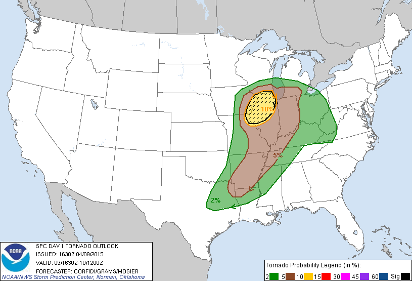
Throughout the evening hours of April 9, 2015, an extremely violent and long-lived multiple-vortex tornado tore through the communities near Rochelle, Illinois, Rochelle and in Fairdale, Illinois. Part of a larger severe weather event that impacted the Central United States, the tornado first touched down in Lee County, Illinois, Lee County at 6:39 p.m. CDT (23:39 UTC). It progressed through the counties of Ogle County, Illinois, Ogle, DeKalb County, Illinois, DeKalb, and Boone County, Illinois, Boone before finally dissipating at 7:20 p.m. CDT. Along the tornado's path, numerous structures were heavily damaged or destroyed, especially in the small town of Fairdale where two fatalities and eleven injuries were recorded. A few well-constructed homes were swept completely away, indicative of peak winds near , the upper bounds of an Enhanced Fujita scale, EF4 tornado. In the aftermath of the event, hundreds of citizens assisted in cleanup and recovery efforts. E ... [...More Info...] [...Related Items...] OR: [Wikipedia] [Google] [Baidu] |
Central Daylight Time
The North American Central Time Zone (CT) is a time zone in parts of Canada, the United States, Mexico, Central America, and a few Caribbean islands. In parts of that zone (20 states in the US, three provinces or territories in Canada, and several border municipalities in Mexico), the Central Time Zone is affected by two time designations yearly: Central Standard Time (CST) is observed from the first Sunday in November to the second Sunday in March. It is six hours behind Coordinated Universal Time (UTC) and designated internationally as UTC−6. From the second Sunday in March to the first Sunday in November the same areas observe daylight saving time (DST), creating the designation of Central Daylight Time (CDT), which is five hours behind UTC and known internationally as UTC−5. Regions using Central Time Canada The province of Manitoba is the only province or territory in Canada that observes Central Time in all areas. The following Canadian provinces and territ ... [...More Info...] [...Related Items...] OR: [Wikipedia] [Google] [Baidu] |
Ohio River Valley
The Ohio River () is a river in the United States. It is located at the boundary of the Midwestern and Southern United States, flowing in a southwesterly direction from Pittsburgh, Pennsylvania, to its mouth on the Mississippi River in Cairo, Illinois. It is the third largest river by discharge volume in the United States and the largest tributary by volume of the Mississippi River. It is also the sixth oldest river on the North American continent. The river flows through or along the border of six states, and its drainage basin includes parts of 14 states. Through its largest tributary, the Tennessee River, the basin includes several states of the southeastern United States. It is the source of drinking water for five million people. The river became a primary transportation route for pioneers during the westward expansion of the early U.S. The lower Ohio River just below Louisville was obstructed by rapids known as the Falls of the Ohio where the elevation falls in re ... [...More Info...] [...Related Items...] OR: [Wikipedia] [Google] [Baidu] |
Gulf Of Mexico
The Gulf of Mexico () is an oceanic basin and a marginal sea of the Atlantic Ocean, mostly surrounded by the North American continent. It is bounded on the northeast, north, and northwest by the Gulf Coast of the United States; on the southwest and south by the Mexican states of Tamaulipas, Veracruz, Tabasco, Campeche, Yucatán, and Quintana Roo; and on the southeast by Cuba. The coastal areas along the Southern U.S. states of Texas, Louisiana, Mississippi, Alabama, and Florida, which border the Gulf on the north, are occasionally referred to as the "Third Coast" of the United States (in addition to its Atlantic and Pacific coasts), but more often as "the Gulf Coast". The Gulf of Mexico took shape about 300 million years ago (mya) as a result of plate tectonics. The Gulf of Mexico basin is roughly oval and is about wide. Its floor consists of sedimentary rocks and recent sediments. It is connected to part of the Atlantic Ocean through the Straits of Florida between the ... [...More Info...] [...Related Items...] OR: [Wikipedia] [Google] [Baidu] |
Mid-South (region)
The Mid-South is an informally-defined region of the United States in the Southern United States, usually thought to be anchored by the Memphis metropolitan area. Exact definitions vary widely and consist of at least West Tennessee, North Mississippi, Northeast Arkansas, Southern Missouri and Missouri Bootheel at a minimum. National Weather Service. Western Kentucky, Arkansas, , Northwest Alabama, and even < ... [...More Info...] [...Related Items...] OR: [Wikipedia] [Google] [Baidu] |
Wisconsin
Wisconsin ( ) is a U.S. state, state in the Great Lakes region, Great Lakes region of the Upper Midwest of the United States. It borders Minnesota to the west, Iowa to the southwest, Illinois to the south, Lake Michigan to the east, Michigan to the northeast, and Lake Superior to the north. With a population of about 6 million and an area of about 65,500 square miles, Wisconsin is the List of U.S. states and territories by population, 20th-largest state by population and the List of U.S. states and territories by area, 23rd-largest by area. It has List of counties in Wisconsin, 72 counties. Its List of municipalities in Wisconsin by population, most populous city is Milwaukee; its List of capitals in the United States, capital and second-most populous city is Madison, Wisconsin, Madison. Other urban areas include Green Bay, Wisconsin, Green Bay, Kenosha, Wisconsin, Kenosha, Racine, Wisconsin, Racine, Eau Claire, Wisconsin, Eau Claire, and the Fox Cities. Geography of Wiscon ... [...More Info...] [...Related Items...] OR: [Wikipedia] [Google] [Baidu] |
Iowa
Iowa ( ) is a U.S. state, state in the upper Midwestern United States, Midwestern region of the United States. It borders the Mississippi River to the east and the Missouri River and Big Sioux River to the west; Wisconsin to the northeast, Illinois to the east and southeast, Missouri to the south, Nebraska to the west, South Dakota to the northwest, and Minnesota to the north. Iowa is the List of U.S. states and territories by area, 26th largest in total area and the List of U.S. states and territories by population, 31st most populous of the List of states and territories of the United States, 50 U.S. states, with a population of 3.19 million. The state's List of capitals in the United States, capital, List of cities in Iowa, most populous city, and largest List of metropolitan statistical areas, metropolitan area fully located within the state is Des Moines, Iowa, Des Moines. A portion of the larger Omaha–Council Bluffs metropolitan area, Omaha, Nebraska, metropolitan area ... [...More Info...] [...Related Items...] OR: [Wikipedia] [Google] [Baidu] |
Kansas
Kansas ( ) is a landlocked U.S. state, state in the Midwestern United States, Midwestern region of the United States. It borders Nebraska to the north; Missouri to the east; Oklahoma to the south; and Colorado to the west. Kansas is named after the Kansas River, in turn named after the Kaw people, Kansa people. Its List of capitals in the United States, capital is Topeka, Kansas, Topeka, and its List of cities in Kansas, most populous city is Wichita, Kansas, Wichita; however, the largest urban area is the bi-state Kansas City metropolitan area split between Kansas and Missouri. For thousands of years, what is now Kansas was home to numerous and diverse Plains Indians, Indigenous tribes. The first settlement of non-indigenous people in Kansas occurred in 1827 at Fort Leavenworth. The pace of settlement accelerated in the 1850s, in the midst of political wars over the Slavery in the United States, slavery debate. When it was officially opened to settlement by the U.S. governm ... [...More Info...] [...Related Items...] OR: [Wikipedia] [Google] [Baidu] |
Northeastern United States
The Northeastern United States (also referred to as the Northeast, the East Coast, or the American Northeast) is List of regions of the United States, census regions United States Census Bureau. Located on the East Coast of the United States, Atlantic coast of North America, the region borders Canada to its north, the Southern United States to its south, the Midwestern United States to its west, and the Atlantic Ocean to its east. The Northeast is one of the four regions defined by the U.S. Census Bureau for the collection and analysis of statistics. The Census Bureau defines the region as including the six New England states of Connecticut, Maine, Massachusetts, New Hampshire, Rhode Island, and Vermont, and three lower North-Eastern states of New Jersey, New York (state), New York, and Pennsylvania. Some expanded definitions of the region include Mid-Atlantic (United States), Mid-Atlantic locations such as Delaware, Maryland, Northern Virginia, and Washington, D.C. The regio ... [...More Info...] [...Related Items...] OR: [Wikipedia] [Google] [Baidu] |
Great Plains
The Great Plains is a broad expanse of plain, flatland in North America. The region stretches east of the Rocky Mountains, much of it covered in prairie, steppe, and grassland. They are the western part of the Interior Plains, which include the mixed grass prairie, the tallgrass prairie between the Great Lakes and Appalachian Plateau, and the Taiga Plains Ecozone, Taiga Plains and Boreal Plains Ecozone, Boreal Plains ecozones in Northern Canada. "Great Plains", or Western Plains, is also the ecoregion of the Great Plains or the western portion of the Great Plains, some of which in the farthest west is known as the High Plains. The Great Plains lie across both the Central United States and Western Canada, encompassing: *Most or all of the U.S. states of Kansas, Nebraska, and North Dakota, North and South Dakota; *Eastern parts of the U.S. states of Colorado, Montana, and Wyoming; *Parts of the U.S. states of New Mexico, Oklahoma, Texas; *Sometimes western parts of Iowa, Minnesot ... [...More Info...] [...Related Items...] OR: [Wikipedia] [Google] [Baidu] |
High Plains (United States)
The High Plains are a subregion of the Great Plains, mainly in the Western United States, but also partly in the Midwestern United States, Midwest states of Nebraska, Kansas, and South Dakota, generally encompassing the western part of the Great Plains before the region reaches the Rocky Mountains. The High Plains are located in eastern Montana, southeastern Wyoming, southwestern South Dakota, western Nebraska, Eastern Plains, eastern Colorado, western Kansas, eastern New Mexico, the Oklahoma Panhandle, and the Texas Panhandle. The southern region of the Western High Plains ecology region contains the geological formation known as Llano Estacado which can be seen from a short distance or on satellite maps. From east to west, the High Plains rise in elevation from around . Name The term "Great Plains", for the region west of about the 96th or 98th meridian and east of the Rocky Mountains, was not generally used before the early 20th century. Nevin M. Fenneman, Nevin Fenneman's 19 ... [...More Info...] [...Related Items...] OR: [Wikipedia] [Google] [Baidu] |
Shortwave (meteorology)
A shortwave or shortwave trough is an embedded kink in the trough / ridge pattern. Its length scale is much smaller than that of and is embedded within longwaves, which are responsible for the largest scale (synoptic scale) weather systems. Shortwaves may be contained within or found ahead of longwaves and range from the mesoscale to the synoptic scale. Shortwaves are most frequently caused by either a cold pool or an upper level front. Shortwaves are commonly referred to as a vorticity maximum. Corresponding weather and effects Shortwaves are often associated with warm air advection (WAA) or cold air advection (CAA), which influence temperature. Due to the way they move the air around them and the way air moves away from them, shortwaves produce positive curvature vorticity and positive shear vorticity, respectively. Ahead of a shortwave there is large-scale lift due to divergence from positive vorticity advection (PVA). This lift often causes precipitation. In a capp ... [...More Info...] [...Related Items...] OR: [Wikipedia] [Google] [Baidu] |


