|
1970 Tonghai Earthquake
An earthquake occurred in Tonghai, Yunnan province, China at 1970 with a moment magnitude of 7.1 and a maximum Mercalli intensity of X (''Extreme''). The strike-slip rupture originated on the Red River Fault, which had not experienced an earthquake above magnitude 7 since 1700. At least 10,000 people were killed, making it one of the deadliest in its decade. The tremor caused between US$5 and $25 million in damage,This would cost roughly US$ million to US$ million in . felt over an area of . In Hanoi, North Vietnam, almost from the epicenter, victims left their homes as the rupture rumbled through the city. Occurring during the height of the Cultural Revolution, it was not widely publicized by the Chinese government for well over a decade. The amount of aid and finances distributed was described by the ''Beijing Morning Post'' as "pathetically small". Much of the aid provided to survivors was in "spiritual" form, including Mao Zedong badges and condolence letters. Neverthe ... [...More Info...] [...Related Items...] OR: [Wikipedia] [Google] [Baidu] [Amazon] |
Fault (geology)
In geology, a fault is a Fracture (geology), planar fracture or discontinuity in a volume of Rock (geology), rock across which there has been significant displacement as a result of rock-mass movements. Large faults within Earth's crust (geology), crust result from the action of Plate tectonics, plate tectonic forces, with the largest forming the boundaries between the plates, such as the megathrust faults of subduction, subduction zones or transform faults. Energy release associated with rapid movement on active faults is the cause of most earthquakes. Faults may also displace slowly, by aseismic creep. A ''fault plane'' is the Plane (geometry), plane that represents the fracture surface of a fault. A ''fault trace'' or ''fault line'' is a place where the fault can be seen or mapped on the surface. A fault trace is also the line commonly plotted on geological maps to represent a fault. A ''fault zone'' is a cluster of parallel faults. However, the term is also used for the zone ... [...More Info...] [...Related Items...] OR: [Wikipedia] [Google] [Baidu] [Amazon] |
Holocene
The Holocene () is the current geologic time scale, geological epoch, beginning approximately 11,700 years ago. It follows the Last Glacial Period, which concluded with the Holocene glacial retreat. The Holocene and the preceding Pleistocene together form the Quaternary period. The Holocene is an interglacial period within the ongoing Ice age, glacial cycles of the Quaternary, and is equivalent to Marine isotope stages, Marine Isotope Stage 1. The Holocene correlates with the last maximum axial tilt towards the Sun of the Earth#Axial tilt and seasons, Earth's obliquity. The Holocene corresponds with the rapid proliferation, growth, and impacts of the human species worldwide, including Recorded history, all of its written history, technological revolutions, development of major civilizations, and overall significant transition towards urban culture, urban living in the present. The human impact on modern-era Earth and its ecosystems may be considered of global significance for th ... [...More Info...] [...Related Items...] OR: [Wikipedia] [Google] [Baidu] [Amazon] |
Linear Seismic Inversion
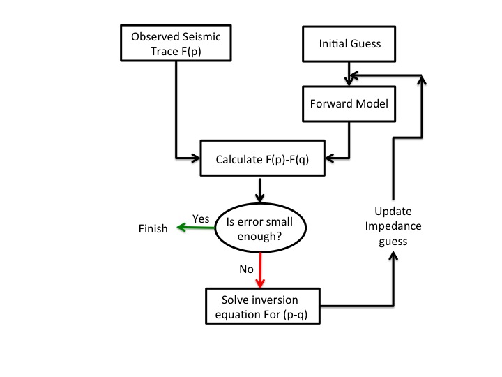
Inverse problem, Inverse modeling is a mathematical technique where the objective is to determine the physical properties of the subsurface of an earth region that has produced a given seismogram. Cooke and Schneider (1983) defined it as calculation of the earth's structure and physical parameters from some set of observed seismic data. The underlying assumption in this method is that the collected seismic data are from an earth structure that matches the cross-section computed from the inversion algorithm. Some common earth properties that are inverted for include acoustic velocity, Formation (stratigraphy), formation and fluid Density, densities, acoustic impedance, Poisson's ratio, formation compressibility, shear rigidity, porosity, and fluid saturation. The method has long been useful for geophysicists and can be categorized into two broad types: Deterministic algorithm, Deterministic and stochastic inversion. Deterministic inversion methods are based on comparison of the outpu ... [...More Info...] [...Related Items...] OR: [Wikipedia] [Google] [Baidu] [Amazon] |
Offset
Offset or Off-Set may refer to: Arts, entertainment, and media * "Off-Set", a song by T.I. and Young Thug from the '' Furious 7: Original Motion Picture Soundtrack'' * ''Offset'' (EP), a 2018 EP by singer Kim Chung-ha * ''Offset'' (film), a 2006 film featuring Răzvan Vasilescu and Alexandra Maria Lara * Offset Software, a video game development company ** '' Project Offset'', working title of a first-person shooter video game by Offset Software People * Offset (rapper), a rapper and member of the American hip-hop trio Migos Science and engineering * Offset (botany), a separable part of a plant that can develop into a new, independent plant * Offset (computer science), the distance to (displacement of) an element within a data object * Offset (gears), the perpendicular distance between the axes of hypoid or offset-facing gears * Offset (geometry), see parallel curve * Offset (geophysics), the distance between a source and receiver of seismic or other geophysical readings * DC ... [...More Info...] [...Related Items...] OR: [Wikipedia] [Google] [Baidu] [Amazon] |
Hong Kong Observatory
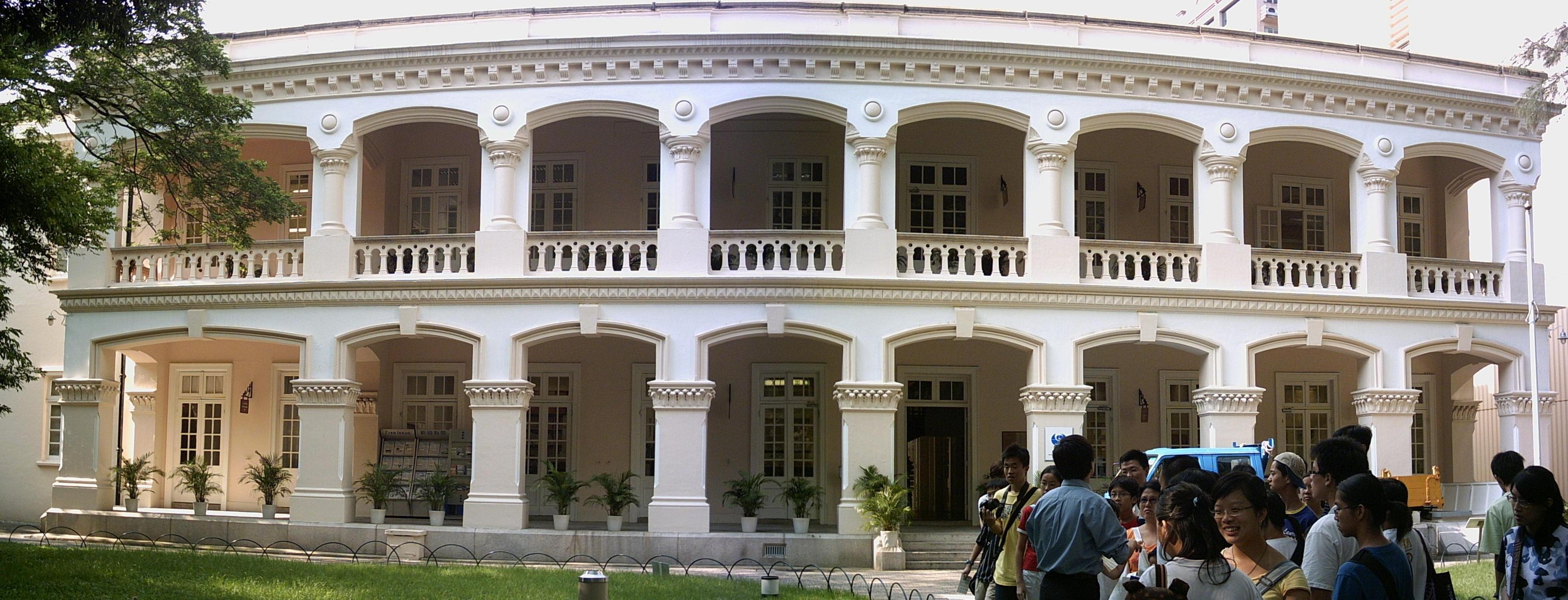
The Hong Kong Observatory is a weather forecast agency of the government of Hong Kong. The Observatory forecasts the weather and issues warnings on weather-related hazards. It also monitors and makes assessments on radiation levels in Hong Kong and provides other meteorological and geophysical services to meet the needs of the public and the shipping, aviation, industrial and engineering sectors. Overview The Observatory was established on 2 March 1883 as the Hong Kong Observatory by Sir George Bowen, the 9th Governor of Hong Kong, with (1852–1941) as its first director. Early operations included meteorological and magnetic observations, a time service based on astronomical observations and a tropical cyclone warning service. The Observatory was renamed the Royal Observatory Hong Kong () after obtaining a Royal Charter in 1912. The Observatory adopted the current name and emblem in 1997 after the transfer of Hong Kong's sovereignty from the UK to China. The Hong K ... [...More Info...] [...Related Items...] OR: [Wikipedia] [Google] [Baidu] [Amazon] |
Moment Magnitude Scale
The moment magnitude scale (MMS; denoted explicitly with or Mwg, and generally implied with use of a single M for magnitude) is a measure of an earthquake's magnitude ("size" or strength) based on its seismic moment. was defined in a 1979 paper by Thomas C. Hanks and Hiroo Kanamori. Similar to the local magnitude scale, local magnitude/Richter scale () defined by Charles Francis Richter in 1935, it uses a logarithmic scale; small earthquakes have approximately the same magnitudes on both scales. Despite the difference, news media often use the term "Richter scale" when referring to the moment magnitude scale. Moment magnitude () is considered the authoritative magnitude scale for ranking earthquakes by size. It is more directly related to the energy of an earthquake than other scales, and does not saturatethat is, it does not underestimate magnitudes as other scales do in certain conditions. It has become the standard scale used by seismological authorities like the United State ... [...More Info...] [...Related Items...] OR: [Wikipedia] [Google] [Baidu] [Amazon] |
Tobacco
Tobacco is the common name of several plants in the genus '' Nicotiana'' of the family Solanaceae, and the general term for any product prepared from the cured leaves of these plants. More than 70 species of tobacco are known, but the chief commercial crop is ''N. tabacum''. The more potent variant ''N. rustica'' is also used in some countries. Dried tobacco leaves are mainly used for smoking in cigarettes and cigars, as well as pipes and shishas. They can also be consumed as snuff, chewing tobacco, dipping tobacco, and snus. Tobacco contains the highly addictive stimulant alkaloid nicotine as well as harmala alkaloids. Tobacco use is a cause or risk factor for many deadly diseases, especially those affecting the heart, liver, and lungs, as well as many cancers. In 2008, the World Health Organization named tobacco use as the world's single greatest preventable cause of death. Etymology The English word 'tobacco' originates from the Spanish word ''taba ... [...More Info...] [...Related Items...] OR: [Wikipedia] [Google] [Baidu] [Amazon] |
Gejiu
Gejiu () (, ; Hani: ''Goqjef''; formerly known as Kochiu) is a county-level city in Honghe Hani and Yi Autonomous Prefecture, Yunnan Province, China, with 202,000 urban inhabitants (ranked 14th largest city in Yunnan). It is the site of China's largest tin deposits and its main industry is mining. Location Gejiu is located on the top of a mountain to the north of the Red River (pinyin ''Hong He'') valley, which flows from Xiangyun, Yunnan, to Vietnam. To the southwest in this valley is Nansha, which lies directly below the town of Yuanyang. To the northwest of Gejiu lies Jianshui County, and to the north, Jijie Town, one of its subordinate towns. Mengzi, the capital city of Honghe prefecture, lies 12 miles east of Gejiu. Layout The town is located in a crater-like depression around a lake on top of a mountain. The main road enters the town from the north through a thin pass. To the east and west are steep cliffs. Those to the west are too steep to inhabit, however, e ... [...More Info...] [...Related Items...] OR: [Wikipedia] [Google] [Baidu] [Amazon] |
Kunming
Kunming is the capital and largest city of the province of Yunnan in China. The political, economic, communications and cultural centre of the province, Kunming is also the seat of the provincial government. During World War II, Kunming was a Chinese military center and the location of the headquarters for the US Army Forces China-Burma-India. Kunming Wujiaba International Airport, Wujiaba Airport served as the home of the Flying Tigers, First American Volunteer Group (AVG) of the Republic of China Air Force, nicknamed the Flying Tigers. Kunming was also a transport terminus for the Burma Road. Kunming is at an altitude of Above mean sea level, above sea level and a latitude just north of the Tropic of Cancer, and is situated in the middle of the Yunnan–Guizhou Plateau. Kunming is the fourth most populous city in Western China, after Chongqing, Chengdu, and Xi'an, and the third most populous city in Southwestern China after Chongqing and Chengdu. As of the 2020 census, Kunmin ... [...More Info...] [...Related Items...] OR: [Wikipedia] [Google] [Baidu] [Amazon] |
Japan Median Tectonic Line
, also Median Tectonic Line (MTL), is Japan's longest Fault (geology), fault system. The MTL begins near Ibaraki Prefecture, where it connects with the Itoigawa-Shizuoka Tectonic Line (ISTL) and the Fossa Magna. It runs parallel to Japan's volcanic arc, passing through central Honshū to near Nagoya, through Mikawa Bay, then through the Seto Inland Sea, Inland Sea from the Kii Channel and Naruto Strait to Shikoku along the Sadamisaki Peninsula and the Bungo Channel and Hōyo Strait to Kyūshū. The sense of motion on the MTL is right-lateral strike-slip, at a rate of about 5–10 mm/yr.Okada, A., On the Quaternary faulting along the Median Tectonic Line, in ''Median Tectonic Line'' (in Japanese with English abstract), edited by R. Sugiyama, pp. 49–86, Tokai Univ. Press, Tokyo, 1973. This sense of motion is consistent with the direction of oblique convergence at the Nankai Trough. The rate of motion on the MTL is much less than the rate of convergence at the Nankai Trough, p ... [...More Info...] [...Related Items...] OR: [Wikipedia] [Google] [Baidu] [Amazon] |


