Vale of the Red Horse on:
[Wikipedia]
[Google]
[Amazon]
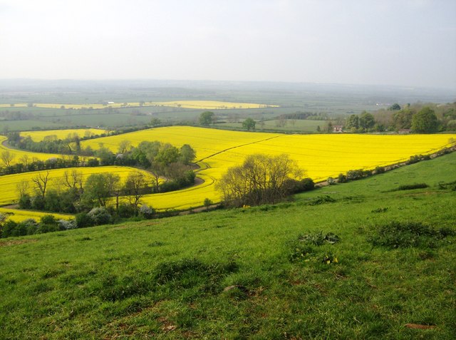
 The Vale of Red Horse, also called the Vale of the Red Horse or Red Horse Vale, is a rural district in southern
 The Vale of Red Horse, also called the Vale of the Red Horse or Red Horse Vale, is a rural district in southern
 Warwickshire
Warwickshire (; abbreviated Warks) is a county in the West Midlands region of England. The county town is Warwick, and the largest town is Nuneaton. The county is famous for being the birthplace of William Shakespeare at Stratford-upon-Av ...
, England
England is a country that is part of the United Kingdom. It shares land borders with Wales to its west and Scotland to its north. The Irish Sea lies northwest and the Celtic Sea to the southwest. It is separated from continental Europe b ...
, lying between the escarpment of Edgehill and the northern Cotswolds around the valley of the Stour.''Proceedings of the Cotteswold Naturalists' Field Club'', v.14, (1903), p.217Pick, S. (1988) ''Exploring Rural England and Wales'', p.71 Early gazetteer
A gazetteer is a geographical index or directory used in conjunction with a map or atlas.Aurousseau, 61. It typically contains information concerning the geographical makeup, social statistics and physical features of a country, region, or con ...
s noted the Vale as a rich corn-growing area, and it is still relatively sparsely populated: its main settlements are Kineton
Kineton is a village and civil parish on the River Dene in south-east Warwickshire, England. The village is part of Stratford-on-Avon district, and in the 2001 census it had a population of 2,278, increasing to 2,337 at the 2011 Census.
Kin ...
and Shipston-on-Stour
Shipston-on-Stour is a town and civil parish in the Stratford-on-Avon District in Warwickshire, England. It is located on the banks of the River Stour, Warwickshire, River Stour, points of the compass, south-southeast of Stratford-upon-Avon, 10 ...
.Beckinsale, R. (1980) ''The English Heartland'', Duckworth, p.5 The Fosse Way runs through the area and the Battle of Edgehill
The Battle of Edgehill (or Edge Hill) was a pitched battle of the First English Civil War. It was fought near Edge Hill and Kineton in southern Warwickshire on Sunday, 23 October 1642.
All attempts at constitutional compromise between ...
was fought on its fringes in October 1642.
The 17th century Warwickshire poet Michael Drayton
Michael Drayton (1563 – 23 December 1631) was an English poet who came to prominence in the Elizabethan era. He died on 23 December 1631 in London.
Early life
Drayton was born at Hartshill, near Nuneaton, Warwickshire, England. Almost nothin ...
devoted a long section of his topographical poem ''Poly-Olbion
The ''Poly-Olbion'' is a topographical poem describing England and Wales. Written by Michael Drayton (1563–1631) and published in 1612, it was reprinted with a second part in 1622. Drayton had been working on the project since at least 1598. ...
'' to what he called the "Vale of Red-horse", noting it was in length "near thirty miles" and deploring its obscurity compared to the better-known Vales of White Horse and Aylesbury.Drayton in Anderson (ed) (1795) ''The Works of the British Poets'', III, p.390
The Vale takes its name from the Red Horse of Tysoe, a hill figure
A hill figure is a large visual representation created by cutting into a steep hillside and revealing the underlying geology. It is a type of geoglyph usually designed to be seen from afar rather than above. In some cases trenches are dug and ...
once cut into the red clay
Clay is a type of fine-grained natural soil material containing clay minerals (hydrous aluminium phyllosilicates, e.g. kaolin, Al2 Si2 O5( OH)4).
Clays develop plasticity when wet, due to a molecular film of water surrounding the clay par ...
near the village of Tysoe
Tysoe is a civil parish in the Stratford-on-Avon District of Warwickshire, England. The parish is on the boundary with Oxfordshire, about northwest of Banbury. The parish includes the contiguous villages of Middle and Upper Tysoe and the sepa ...
. The Red Horse was first recorded in 1607, and in its earliest form was nearly 100 yards long.Pevsner, Nikolaus and Wedgewood, Alexandra. ''The Buildings of England: Warwickshire'', Penguin, 1966, p.543 Various dates have been suggested for the figure's creation, ranging from the Anglo-Saxon period to the 15th century. It was lost by the First World War.
The Vale of Red Horse has given its name to an electoral ward of Stratford-upon-Avon and an electoral division of Warwickshire
Warwickshire (; abbreviated Warks) is a county in the West Midlands region of England. The county town is Warwick, and the largest town is Nuneaton. The county is famous for being the birthplace of William Shakespeare at Stratford-upon-Av ...
. The modern ward boundaries, which include the villages of Tysoe
Tysoe is a civil parish in the Stratford-on-Avon District of Warwickshire, England. The parish is on the boundary with Oxfordshire, about northwest of Banbury. The parish includes the contiguous villages of Middle and Upper Tysoe and the sepa ...
, Oxhill, Whatcote, Pillerton Priors, Pillerton Hersey and Butlers Marston are smaller than the historic area of the Vale, which was considered to include all the low-lying ground separating the north Cotswolds from Edgehill."The Boundaries of the Cotswolds" in ''The Geographical Journal'', Volume 24 (1904), 91
See also
*Vale of White Horse
The Vale of White Horse is a local government district of Oxfordshire in England. It was historically a north-west projection of Berkshire. The area is commonly referred to as the 'Vale of ''the'' White Horse'. It is crossed by the Ridgeway N ...
References
{{coord, 52.124129, -1.529377, type:landmark_region:GB-WAR, display=title Geography of Warwickshire Valleys of Warwickshire Cotswolds