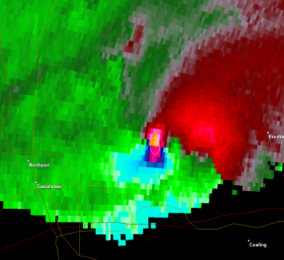
Tornado vortex signature on:
[Wikipedia]
[Google]
[Amazon]
 A tornadic vortex signature, abbreviated TVS, is a
 The conditions causing a TVS are often visible on the Doppler weather radar storm relative velocity (SRV) product as adjacent inbound and outbound velocities, a signature known as a velocity couplet or "gate-to-gate" shear. In most cases, the TVS is a strong mesocyclone aloft, not an actual
Tornado Vortex Signatures in Doppler radial velocity patterns
Severe weather and convection Radar meteorology
 A tornadic vortex signature, abbreviated TVS, is a
 Pulse-Doppler radar
A pulse-Doppler radar is a radar system that determines the range to a target using pulse-timing techniques, and uses the Doppler effect of the returned signal to determine the target object's velocity. It combines the features of pulse radars and ...
weather radar
Weather radar, also called weather surveillance radar (WSR) and Doppler weather radar, is a type of radar used to locate precipitation, calculate its motion, and estimate its type (rain, snow, hail etc.). Modern weather radars are mostly pulse- ...
detected rotation algorithm
In mathematics and computer science, an algorithm () is a finite sequence of rigorous instructions, typically used to solve a class of specific problems or to perform a computation. Algorithms are used as specifications for performing ...
that indicates the likely presence of a strong mesocyclone
A mesocyclone is a meso-gamma mesoscale (or storm scale) region of rotation (vortex), typically around in diameter, most often noticed on radar within thunderstorms. In the northern hemisphere it is usually located in the right rear flank (back ...
that is in some stage of tornadogenesis
Tornadogenesis is the process by which a tornado forms. There are many types of tornadoes and these vary in methods of formation. Despite ongoing scientific study and high-profile research projects such as VORTEX, tornadogenesis is a volatile pro ...
. It may give meteorologists the ability to pinpoint and track the location of tornadic rotation within a larger storm, but it is not an important feature in the National Weather Service
The National Weather Service (NWS) is an agency of the United States federal government that is tasked with providing weather forecasts, warnings of hazardous weather, and other weather-related products to organizations and the public for the ...
's warning operations.
The tornadic vortex signature was first identified by Donald W. Burgess, Leslie R. Lemon, and Rodger A. Brown in the 1970s using experimental Doppler radar at the National Severe Storms Laboratory
The National Severe Storms Laboratory (NSSL) is a National Oceanic and Atmospheric Administration (NOAA) weather research laboratory under the Office of Oceanic and Atmospheric Research. It is one of seven NOAA Research Laboratories (RLs).
NSSL ...
(NSSL) in Norman, Oklahoma
Norman () is the third-largest city in the U.S. state of Oklahoma, with a population of 128,097 as of 2021. It is the largest city and the county seat of Cleveland County, and the second-largest city in the Oklahoma City metropolitan area, be ...
. The National Weather Service (NWS) now uses an updated algorithm developed by NSSL, the ''tornado detection algorithm'' (TDA) based on data from its WSR-88D system of radars. NSSL also developed the ''mesocyclone detection algorithm'' (MDA).
Display
 The conditions causing a TVS are often visible on the Doppler weather radar storm relative velocity (SRV) product as adjacent inbound and outbound velocities, a signature known as a velocity couplet or "gate-to-gate" shear. In most cases, the TVS is a strong mesocyclone aloft, not an actual
 tornado
A tornado is a violently rotating column of air that is in contact with both the surface of the Earth and a cumulonimbus cloud or, in rare cases, the base of a cumulus cloud. It is often referred to as a twister, whirlwind or cyclone, alt ...
, although the presence of an actual tornado on the ground can occasionally be inferred based on a strong couplet in concert with a '' tornado debris signature'' (TDS) (i.e. a "debris ball" on reflectivity or certain polarimetric characteristics), or through confirmation from storm spotters. When the algorithm is tripped, a TVS icon (typically a triangle representing a vortex
In fluid dynamics, a vortex ( : vortices or vortexes) is a region in a fluid in which the flow revolves around an axis line, which may be straight or curved. Vortices form in stirred fluids, and may be observed in smoke rings, whirlpools in ...
) and pertinent information appear. Radar analysis of the velocity couplet as well as the automated TVS are very significant to issuing tornado warning
A tornado warning ( SAME code: TOR) is a severe weather warning product issued by regional offices of weather forecasting agencies throughout the world to alert the public when a tornado has been reported or indicated by weather radar within the ...
s and can suggest the strength and location of possible tornadoes. Although many tornadoes, especially the stronger ones, coincide with a TVS, many weak EF0-EF1 tornadoes can and do occur without a TVS, especially if they are not produced from an identified mesocyclone. Likewise, phenomena such as "fair-weather" waterspouts, landspout __NOTOC__
Landspout is a term created by atmospheric scientist Howard B. Bluestein in 1985 for a kind of tornado not associated with a mesocyclone. The ''Glossary of Meteorology'' defines a landspout as
: "Colloquial expression describing torn ...
s, and gustnado
A gustnado is a brief, shallow surface-based vortex which forms within the downburst emanating from a thunderstorm. The name is a portmanteau by elision of "gust front tornado", as gustnadoes form due to non-tornadic straight-line wind featur ...
es, though cyclonic and occasionally damaging, do not normally produce a signature identifiable by a TVS. Rotation associated with quasi-linear convective systems (QLCSs) or squall line
A squall line, or more accurately a quasi-linear convective system (QLCS), is a line of thunderstorms, often forming along or ahead of a cold front. In the early 20th century, the term was used as a synonym for cold front (which often are accom ...
s can trip the TVS but do so less reliably as the couplets typically are more transient, are shallower, smaller, and weaker. This rotation may be considered a mesovortex A mesovortex is a small-scale rotational feature found in a convective storm, such as a quasi-linear convective system (QLCS, i.e. squall line), a supercell, or the eyewall of a tropical cyclone. Mesovortices range in diameter from tens of miles ...
rather than a mesocyclone but these do produce tornadoes and damaging straight-line wind
In meteorology, a downburst is a strong downward and outward gushing wind system that emanates from a point source above and blows Rotational symmetry, radially, that is, in straight lines in all directions from the area of impact at surface l ...
s.
Intensity
A TVS can be measured by intense gate to gatewind shear
Wind shear (or windshear), sometimes referred to as wind gradient, is a difference in wind speed and/or direction over a relatively short distance in the atmosphere. Atmospheric wind shear is normally described as either vertical or horizont ...
, which is the change of wind speed
In meteorology, wind speed, or wind flow speed, is a fundamental atmospheric quantity caused by air moving from high to low pressure, usually due to changes in temperature. Wind speed is now commonly measured with an anemometer.
Wind speed ...
and/or direction across the two gates of inbound and outbound velocities. Gates are the individual pixels on the radar display. For example, if the inbound velocity is and the outbound is , then there is of gate to gate shear. The impressiveness of a TVS not only has to do with the strength of the gate to gate shear, but it also incorporates the size and depth of the TVS, and the strength of any surrounding mesocyclone, among other factors, including several vertically-polarized variables with the advent of dual-polarization. WSR-88D Distance Learning Operations Course, slide 9
See also
*Convective storm detection
Convective storm detection is the meteorological observation, and short-term prediction, of deep moist convection (DMC). DMC describes atmospheric conditions producing single or clusters of large vertical extension clouds ranging from cumulus co ...
* Hook echo
A hook echo is a pendant or hook-shaped weather radar signature as part of some supercell thunderstorms. It is found in the lower portions of a storm as air and precipitation flow into a mesocyclone, resulting in a curved feature of reflectivit ...
* Bounded weak echo region
The bounded weak echo region, also known as a BWER or a vault, is a radar signature within a thunderstorm characterized by a local minimum in radar reflectivity at low levels which extends upward into, and is surrounded by, higher reflectivities a ...
(BWER)
* Warning Decision Training Branch, Cooperative Institute for Mesoscale Meteorological Studies
The Cooperative Institute for Mesoscale Meteorological Studies is a research organization created in 1978 by a cooperative agreement between the University of Oklahoma (OU) and the National Oceanic and Atmospheric Administration (NOAA). CIMMS p ...
, Center for Analysis and Prediction of Storms
The Center for Analysis and Prediction of Storms (CAPS) was established at the University of Oklahoma in 1989 as one of the first eleven National Science Foundation Science and Technology Centers. Located at the National Weather Center in Norman, ...
, Advanced Radar Research Center
The Advanced Radar Research Center (ARRC) is the largest academic radar program in the United States. The ARRC’s mission is to enhance safety, security, environmental quality, and economic prosperity through interdisciplinary research and the dev ...
Notes
References
* * {{cite journal, last = Rodger Brown and Vincent Wood, National Severe Storms Laboratory, title = The Tornadic Vortex Signature: An Update, journal = Weather and Forecasting, location = Online, accessdate = 2020-03-26, date = April 2012, volume = 27, issue = 2, pages = 525–530, doi = 10.1175/WAF-D-11-00111.1, bibcode = 2012WtFor..27..525B, s2cid = 122590037, url = https://journals.ametsoc.org/doi/full/10.1175/WAF-D-11-00111.1External links
Tornado Vortex Signatures in Doppler radial velocity patterns
Severe weather and convection Radar meteorology