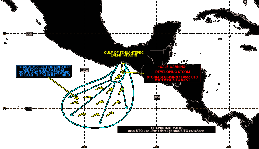
Tehuano wind on:
[Wikipedia]
[Google]
[Amazon]
 Tehuantepecer, or Tehuano wind, is a violent
 Its leading edge shows up as a rope cloud within the visible and infrared channels of weather satellite images, and since it lies at the leading edge of a density (
 Tehuantepecer, or Tehuano wind, is a violent
 mountain-gap wind
A mountain-gap wind, gap wind or gap flow is a local wind blowing through a gap between mountains.
Gap winds are low-level winds and can be associated with strong winds of 20-40 knots and on occasion exceeding 50 knots. Gap winds are generally st ...
that travels through the Chivela Pass
The Chivela Pass is a narrow mountain pass in the Sierra Madre Mountains that funnels cooler, drier air from the North American continent, through southern Mexico, into the Pacific. These northeasterly winds, specifically the Tehuano wind, which ...
in southern Mexico
Mexico (Spanish language, Spanish: México), officially the United Mexican States, is a List of sovereign states, country in the southern portion of North America. It is borders of Mexico, bordered to the north by the United States; to the so ...
, across the Isthmus of Tehuantepec
The Isthmus of Tehuantepec () is an isthmus in Mexico. It represents the shortest distance between the Gulf of Mexico and the Pacific Ocean. Before the opening of the Panama Canal, it was a major overland transport route known simply as the T ...
. It is most common between October and February, with a summer minimum in July. It originates from eastern Mexico and the Bay of Campeche
The Bay of Campeche ( es, Bahía de Campeche), or Campeche Sound, is a bight in the southern area of the Gulf of Mexico, forming the north side of the Isthmus of Tehuantepec. It is surrounded on three sides by the Mexican states of Campeche, ...
as a post-frontal northerly wind, accelerated southward by cold air damming
Cold air damming, or CAD, is a meteorological phenomenon that involves a high-pressure system (anticyclone) accelerating equatorward east of a north-south oriented mountain range due to the formation of a barrier jet behind a cold front associated ...
, that crosses the isthmus and blows through the gap between the Mexican and Guatemalan mountains. The term dates back to at least 1929. This wind can reach gale, storm, even hurricane force. The leading edge of its outflow (or cold front
A cold front is the leading edge of a cooler mass of air at ground level that replaces a warmer mass of air and lies within a pronounced surface trough of low pressure. It often forms behind an extratropical cyclone (to the west in the Northern ...
) may form rope cloud over the Gulf of Tehuantepec
Gulf of Tehuantepec () is a large body of water on the Pacific coast of the Isthmus of Tehuantepec, southeastern Mexico, at . Many (but not all) Pacific hurricanes form in or near this body of water. A strong, gale-force wind called the Tehu ...
. These winds can be observed on satellite pictures such as scatterometer wind measurements, they influence waves which then propagate as swell and are sometimes observed away (such as in the Galapagos Islands). These strong winds bring cooler sub-surface waters to the surface of the tropical eastern Pacific Ocean and may last from a few hours to 6 days.
Climatology
The synoptic condition is associated with the formation of high-pressure systems inSierra Madre
Sierra Madre (Spanish, 'mother mountain range') may refer to:
Places and mountains Mexico
*Sierra Madre Occidental, a mountain range in northwestern Mexico and southern Arizona
*Sierra Madre Oriental, a mountain range in northeastern Mexico
*S ...
in the wake of an advancing cold front. Tehuantepecers primarily occur during the cold season months for the region in the wake of cold fronts, between October and February, with a summer minimum in July caused by the westward extension of the Azores-Bermuda high pressure system. Wind magnitude is greater during El Niño
El Niño (; ; ) is the warm phase of the El Niño–Southern Oscillation (ENSO) and is associated with a band of warm ocean water that develops in the central and east-central equatorial Pacific (approximately between the International Date ...
years than during La Niña years, due to the more frequent cold frontal incursions during El Niño winters. Tehuantepec winds reach to , and on rare occasions . The wind's direction is from the north to north-northeast. It leads to a localized acceleration of the trade wind
The trade winds or easterlies are the permanent east-to-west prevailing winds that flow in the Earth's equatorial region. The trade winds blow mainly from the northeast in the Northern Hemisphere and from the southeast in the Southern Hemisph ...
s in the region, and can enhance thunderstorm
A thunderstorm, also known as an electrical storm or a lightning storm, is a storm characterized by the presence of lightning and its acoustic effect on the Earth's atmosphere, known as thunder. Relatively weak thunderstorms are some ...
activity when it interacts with the Intertropical Convergence Zone
The Intertropical Convergence Zone (ITCZ ), known by sailors as the doldrums or the calms because of its monotonous windless weather, is the area where the northeast and the southeast trade winds converge. It encircles Earth near the thermal ...
. The effects can last from a few hours to six days.
As seen by weather satellites
 Its leading edge shows up as a rope cloud within the visible and infrared channels of weather satellite images, and since it lies at the leading edge of a density (
temperature
Temperature is a physical quantity that expresses quantitatively the perceptions of hotness and coldness. Temperature is measured with a thermometer.
Thermometers are calibrated in various temperature scales that historically have relied o ...
and dew point
The dew point is the temperature to which air must be cooled to become saturated with water vapor, assuming constant air pressure and water content. When cooled below the dew point, moisture capacity is reduced and airborne water vapor will ...
) discontinuity, its leading edge by definition it is a cold front, though it has also been described as a squall line
A squall line, or more accurately a quasi-linear convective system (QLCS), is a line of thunderstorms, often forming along or ahead of a cold front. In the early 20th century, the term was used as a synonym for cold front (which often are accom ...
, with embedded rain squalls sometimes seen. Within polar orbiting imagery, a corridor of strong low-level winds show up this feature within scatterometer data retrievals, with its leading edge at the south to southwest edge of the wind surge.
Ocean impact
Tehuantepecers can be felt up to out to sea in the tropical eastern Pacific Ocean. Sustained winds at sea have been recorded as high as , with gusts as high as , with a wind event in February 1974 which sandblasted the ship which took the observation. These winds cause waves which then propagate as swell and are sometimes observed away (e.g., in the Galapagos Islands). Its effects can appear similar to a tropical cyclone, though the sky is usually clear. The surface wind can also change local ocean currents during an event. These strong winds upwell sub-surface waters, cooling the tropical eastern Pacific Ocean by as much as 14 °F (9 °C), and may last 4–7 days.References
{{reflist, 2Other reading
*Steenburgh, W.J., D.M. Schultz, B.A. Colle, 1998: The Structure and Evolution of Gap Outflow over the Gulf of Tehuantepec, Mexico. ''Monthly Weather Review
The ''Monthly Weather Review'' is a peer-reviewed scientific journal published by the American Meteorological Society. It covers research related to analysis and prediction of observed and modeled circulations of the atmosphere, including techniqu ...
'', Vol. 126, pp. 2673–2691
*Bourassa MA, Zamudio L, O’Brien JJ, Noninertial flow in NSCAT observations of Tehuantepec winds, ''Journal of Geophysical Research-Oceans'', 104 (C5): 11311-11319 MAY 15 1999
*Chelton DB, Freilich MH, Esbensen SK, Satellite observations of the wind jets off the Pacific coast of Central America. Part I: Case studies and statistical characteristics, ''Monthly Weather Review'', 128 (7): 1993-2018 Part 1 JUL 2000
Winds