Takachiho, Miyazaki on:
[Wikipedia]
[Google]
[Amazon]
is a
 * Miyazaki Prefecture
** Nishiusuki District: Gokase, Hinokage
** Higashiusuki District: Morotsuka
* Kumamoto Prefecture
** Aso District: Takamori
** Kamimashiki District: Yamato
* Ōita Prefecture
** Taketa
** Bungo-ōno

 Takachiho is the heart of the Himuka Myth Road, which extends throughout Miyazaki.
* Takachiho Gorge
**Manai Waterfall
*Kunimigaoka
* Ama-no-iwato Jinja Shinto Shrine
* Shonenji Temple
*Takachiho Onsen
*Takachiho Shrine
Official website
Takachiho-cho Tourism Association
* * Towns in Miyazaki Prefecture {{Miyazaki-geo-stub
town
A town is a human settlement. Towns are generally larger than villages and smaller than cities, though the criteria to distinguish between them vary considerably in different parts of the world.
Origin and use
The word "town" shares an ori ...
in Nishiusuki District, Miyazaki Prefecture, Japan. As of October 1, 2019, the town has an estimated population of 11,959 and a density of 50.3 persons per km². The total area is 237.54 km².
Geography
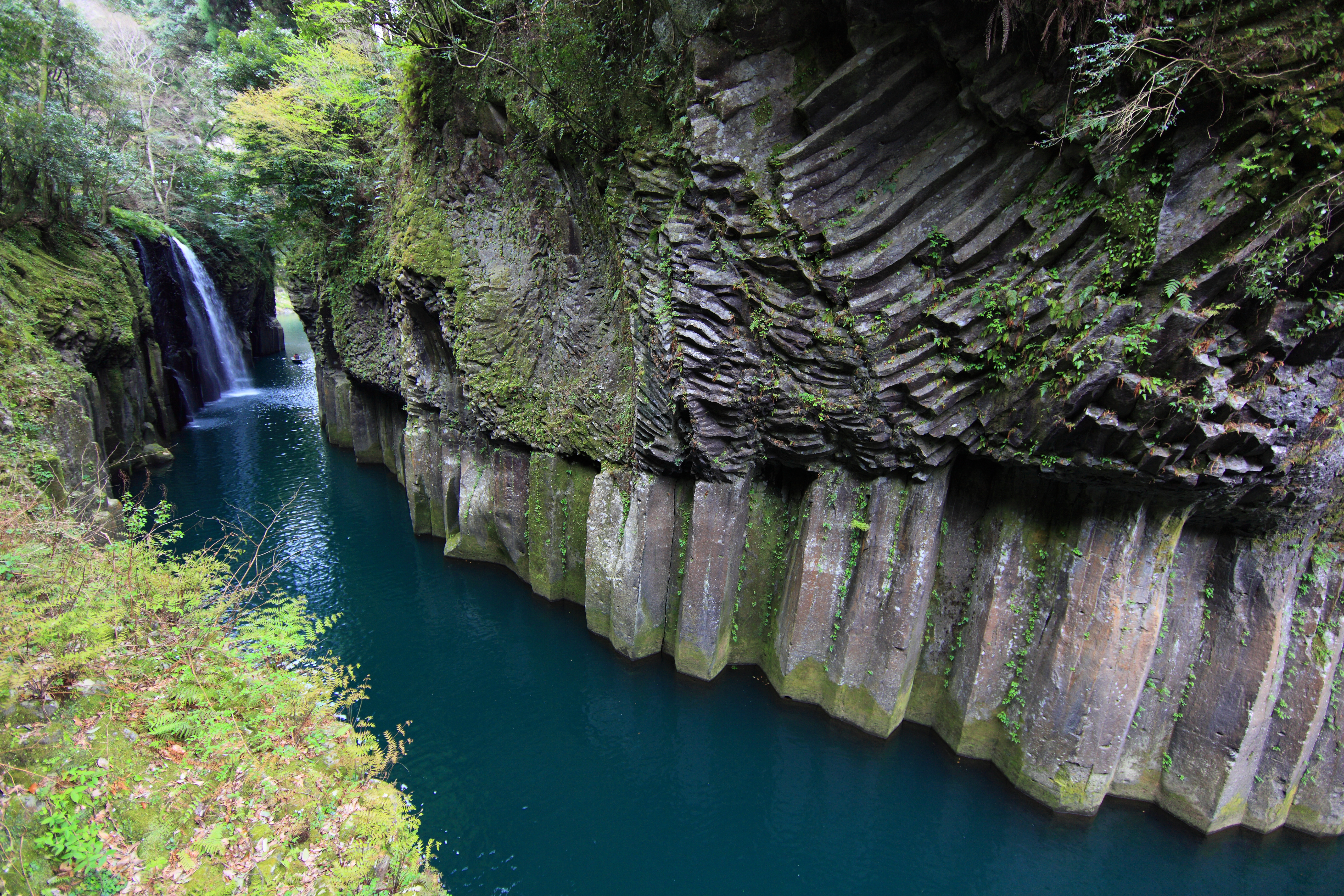
Takachiho is in the northernmost part of Miyazaki Prefecture, bordering Kumamoto Prefecture on its north and northwest sides and Ōita Prefecture on its north and northeast sides. The Gokase River flows from the west to the southeast part of town. The heart of the town is at its center, around the now-defunct Takachiho Station and the business office of Takachiho Kotsu, the town's public transportation company. Takachiho Gorge, in the southern part of town, is fairly famous as a tourist attraction. Takachiho is about 120 km northwest of the prefectural capital of Miyazaki and about 80 km southeast of the city ofKumamoto
is the capital city of Kumamoto Prefecture on the island of Kyushu, Japan. , the city has an estimated population of 738,907 and a population density of 1,893 people per km2. The total area is 390.32 km2.
had a population of 1,461,000, ...
. Due to no public transportation facilities, nor any national highways
National Highways, formerly the Highways Agency and later Highways England, is a government-owned company charged with operating, maintaining and improving motorways and major A roads in England. It also sets highways standards used by all f ...
to Miyazaki, it takes about three hours to get there.
Neighboring municipalities
 * Miyazaki Prefecture
** Nishiusuki District: Gokase, Hinokage
** Higashiusuki District: Morotsuka
* Kumamoto Prefecture
** Aso District: Takamori
** Kamimashiki District: Yamato
* Ōita Prefecture
** Taketa
** Bungo-ōno
Climate
Takachiho has a humid subtropical climate (Köppen climate classification
The Köppen climate classification is one of the most widely used climate classification systems. It was first published by German-Russian climatologist Wladimir Köppen (1846–1940) in 1884, with several later modifications by Köppen, notabl ...
''Cfa'') with hot, humid summers and cool winters. The average annual temperature in Takachiho is . The average annual rainfall is with June as the wettest month. The temperatures are highest on average in August, at around , and lowest in January, at around . The highest temperature ever recorded in Takachiho was on 16 July 2006; the coldest temperature ever recorded was on 19 February 1977.
Demographics
Per Japanese census data, the population of Takachiho in 2020 is 11,642 people. Takachiho has been conducting censuses since 1960.History
During World War Two, the 2nd Raiding Brigade trained in the town and were sometimes known as the Takachiho paratroopers.
Mythology
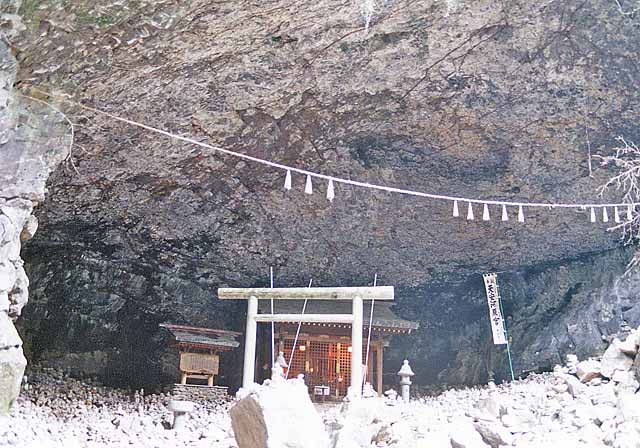
According to Japanese mythology, Takachiho is the land where Ninigi descended from the heavens, sent by Amaterasu, the sun goddess. It contains theAma-no-Iwato
is a cave in Japanese mythology. According to the ''Kojiki'' (''Records of Ancient Matters'') and the '' Nihon Shoki'', the bad behavior of Susano'o, the Japanese god of storms, drove his sister Amaterasu into the Ama-no-Iwato cave. The land wa ...
shrine which is, according to myth, the location of the cave where Amaterasu hid until Ame-no-Uzume
is the goddess of dawn, mirth, meditation, revelry and the arts in the Shinto religion of Japan, and the wife of fellow-god Sarutahiko Ōkami. She famously relates to the tale of the missing sun deity, Amaterasu Omikami. Her name can also be p ...
lured her out.
Education
Prefectural high schools
*Takachiho High SchoolJunior high schools
*Takachiho Junior High School *Tabaru Junior High School *Iwato Junior High School *Kamino Junior High SchoolElementary schools
*Takachiho Elementary School *Oshikata Elementary School *Tabaru Elementary School *Iwato Elementary School *Kamino Elementary SchoolTransportation
Air
The nearest airport isKumamoto Airport
, also known as , is an airport in Mashiki, Kumamoto, Japan.
History
The first Kumamoto Airport opened in 1960 on the site of a former Imperial Japanese Army air base and had a 1,200 m runway. It was replaced by the current Kumamoto Airport i ...
.
Rail
* Takachiho Railway **Takachiho Line (inactive) ***Ama-no-iwato Station - Takachiho StationRoad
*National highways
National Highways, formerly the Highways Agency and later Highways England, is a government-owned company charged with operating, maintaining and improving motorways and major A roads in England. It also sets highways standards used by all f ...
** Japan National Route 218
***Takachiho Roadside Station
** Japan National Route 325
Scenic and historic places
 Takachiho is the heart of the Himuka Myth Road, which extends throughout Miyazaki.
* Takachiho Gorge
**Manai Waterfall
*Kunimigaoka
* Ama-no-iwato Jinja Shinto Shrine
* Shonenji Temple
*Takachiho Onsen
*Takachiho Shrine
References
External links
Official website
Takachiho-cho Tourism Association
* * Towns in Miyazaki Prefecture {{Miyazaki-geo-stub