Seefeld Plateau on:
[Wikipedia]
[Google]
[Amazon]
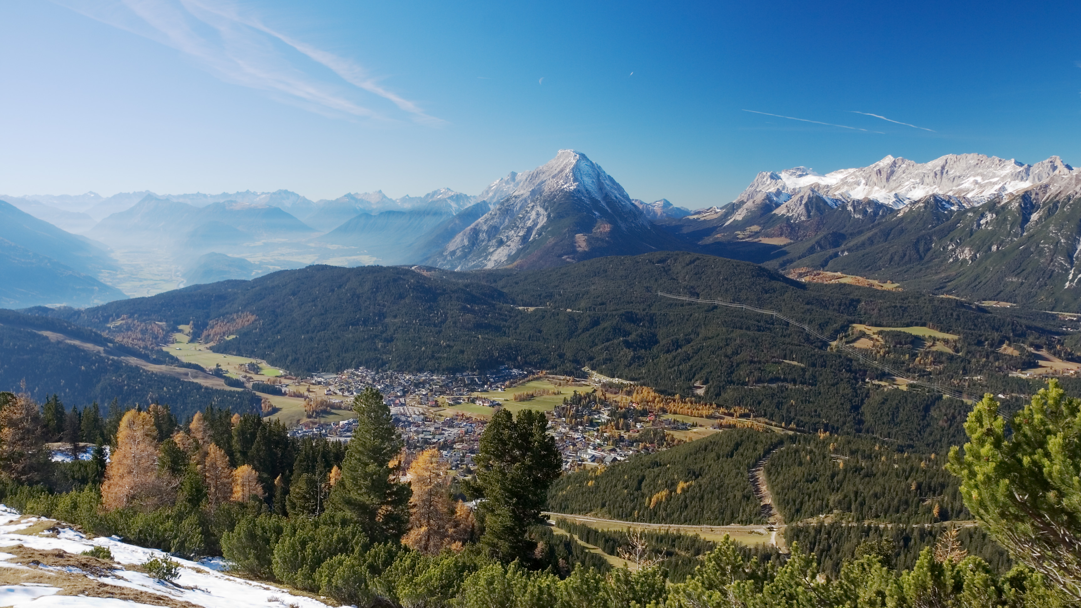
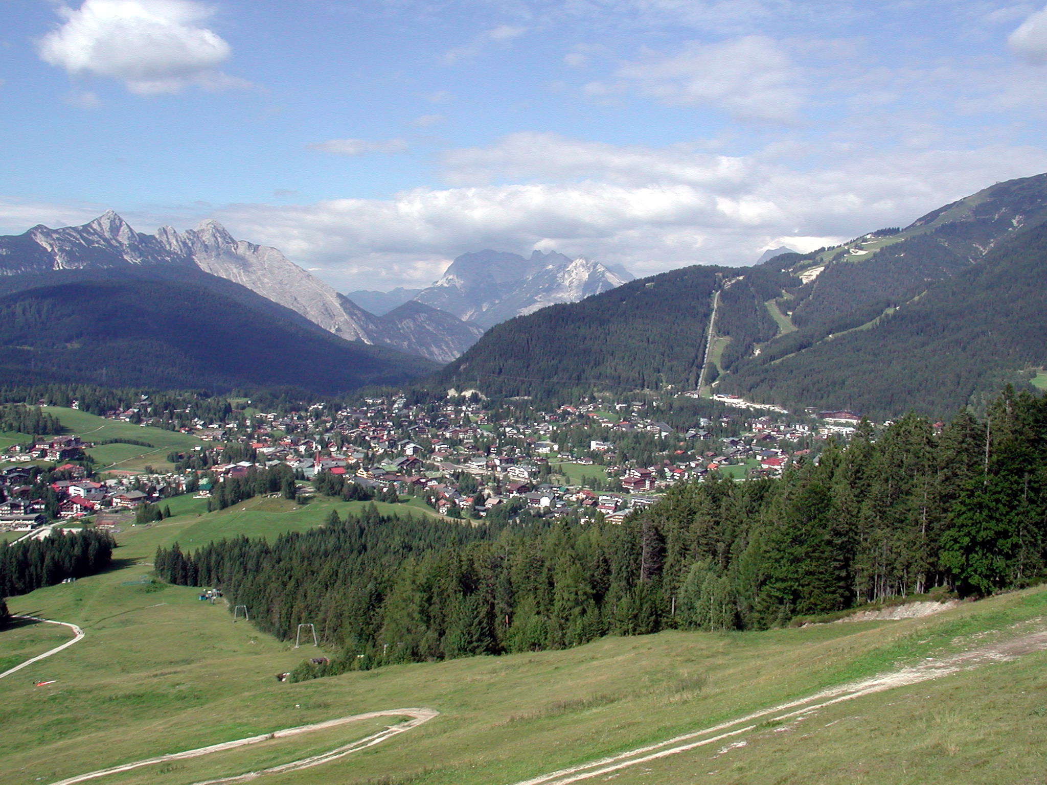
 The Seefeld Plateau (german: Seefelder Plateau) is a montane valley and basin landscape in the North Tyrolean Limestone Alps about 500 metres above the
 The dominant rocks of the Seefeld Plateaus are Wetterstein limestone and
 With around 1.74 million overnight stays per year, evenly divided between winter and summer (as at 2013), tourism is by far the most important economic factor on the Seefeld Plateau. The area has developed itself into a centre for Nordic skiing and was the venue for Nordic competitions in the
Andrea Bucher, Wolfgang Hofbauer, Georg Gärtner
''Beitrag zur Moosflora von Seefeld und Umgebung und des Leutascher Beckens (Nordtirol)''
In: Berichte des naturwissenschaftlich-medizinischen Vereins in Innsbruck, Vol. 80 (1993), pp. 53–67 (pdf; 2.6 MB) State of Tyrol: Regional profile Seefeld Plateau – 2014 statistics
(pdf; 734 kB)
Planungsverband 14 – Seefelder Plateau
Land Tirol, auf tirol.gv.at
Seefelder Plateau
Tirol Atlas der Universität Innsbruck, auf tirolatlas.uibk.ac.at Regions of Tyrol (state) Innsbruck-Land District Karwendel Wetterstein Mieming Range
 The Seefeld Plateau (german: Seefelder Plateau) is a montane valley and basin landscape in the North Tyrolean Limestone Alps about 500 metres above the
 Inn valley
The Inn ( la, Aenus; rm, En) is a river in Switzerland, Austria and Germany. The river is long. It is a right tributary of the Danube and it is the third largest tributary of the Danube by discharge. The highest point of its drainage basin is ...
in the Austria
Austria, , bar, Östareich officially the Republic of Austria, is a country in the southern part of Central Europe, lying in the Eastern Alps. It is a federation of nine states, one of which is the capital, Vienna, the most populous ...
n state of Tyrol
Tyrol (; historically the Tyrole; de-AT, Tirol ; it, Tirolo) is a historical region in the Alps - in Northern Italy and western Austria. The area was historically the core of the County of Tyrol, part of the Holy Roman Empire, Austrian Emp ...
. The plateau covers the valley basin around the villages of Seefeld in Tirol
Seefeld in Tirol is an old farming village, now a major tourist resort, in Innsbruck-Land District in the Austrian state of Tyrol with a local population of 3,312 (as of 1 January 2013). The village is located about northwest of Innsbruck on a pl ...
and Scharnitz
Scharnitz is a municipality in the district of Innsbruck-Land in the Austrian state of Tyrol located north of Innsbruck and from Seefeld in Tirol on the German border. It is one of the largest municipalities and has 10 parts: Au, Eisack, Gieße ...
as well as the valley of ''Leutaschtal''.
Location
The Seefeld Plateau runs northwards from the edge of the Inn graben at theZirler Berg
The Zirler Berg near Zirl in the Austrian federal state of Tyrol (Bundesland), Tyrol is a mountain, high, in the Karwendel Alps, a western part of the Northern Limestone Alps. It is a southern foothill of the Reither Spitze (2,374 m) and ...
. It lies at a height of around in the North Tyrolean Limestone Alps between the Wetterstein Mountains
The Wetterstein mountains (german: Wettersteingebirge), colloquially called Wetterstein, is a mountain group in the Northern Limestone Alps within the Eastern Alps. It is a comparatively compact range located between Garmisch-Partenki ...
to the northwest, the Mieming Mountains to the west and the Karwendel
The Karwendel is the largest mountain range of the Northern Limestone Alps. The major part belongs to the Austrian federal state of Tyrol, while the adjacent area in the north is part of Bavaria, Germany. Four chains stretch from west to east; i ...
to the east. The Seefeld Saddle (), a mountain pass and saddle
The saddle is a supportive structure for a rider of an animal, fastened to an animal's back by a girth. The most common type is equestrian. However, specialized saddles have been created for oxen, camels and other animals. It is not k ...
south of Seefeld, forms a watershed, north of which the plateau drains towards the Isar and south of which it drains into the Inn
Inns are generally establishments or buildings where travelers can seek lodging, and usually, food and drink. Inns are typically located in the country or along a highway; before the advent of motorized transportation they also provided accommo ...
.
Geology and flora
 The dominant rocks of the Seefeld Plateaus are Wetterstein limestone and
 main dolomite
Main Dolomite (german: Hauptdolomit, hu, Fődolomit, it, Dolomia Principale) is a lithostratigraphic unit in the Alps of Europe. Formation was defined by K.W. Gümbel in 1857.
Middle to Late Triassic sedimentary record in the Alpine realm is ...
with scattered occurrences of bituminous
Asphalt, also known as bitumen (, ), is a sticky, black, highly viscous liquid or semi-solid form of petroleum. It may be found in natural deposits or may be a refined product, and is classed as a pitch. Before the 20th century, the term ...
slate. A branch of the ice age
An ice age is a long period of reduction in the temperature of Earth's surface and atmosphere, resulting in the presence or expansion of continental and polar ice sheets and alpine glaciers. Earth's climate alternates between ice ages and gre ...
Inn Glacier
The Inn Glacier (german: Inn-Gletscher), also called the Inn Valley Glacier (''Inntal-Gletscher''). was the ice age glacier of the Alpine river, the Inn. Originating in the Swiss Upper and Lower Engadine (in the present canton of Graubünden), ...
scoured out several basins and left lakes behind such as the Wildsee, the Möserer See and the Wildmoossee
The Wildmoossee is an aperiodic mountain lake, 3 kilometres west of Seefeld in Tirol near the village of Wildmoos in the market borough of Telfs.
The lake lies in the area of the water-soluble main dolomite of the Seefeld Plateau at a heig ...
as well as numerous raised bog
Raised bogs, also called ombrotrophic bogs, are acidic, wet habitats that are poor in mineral salts and are home to flora and fauna that can cope with such extreme conditions. Raised bogs, unlike fens, are exclusively fed by precipitation (ombrot ...
s like the Reither Moor that were formed by the silting up
Siltation, is water pollution caused by particulate terrestrial clastic material, with a particle size dominated by silt or clay. It refers both to the increased concentration of suspended sediments and to the increased accumulation (temporary or ...
of lakes.
The plateau lies in the montane altitude zone
Altitudinal zonation (or elevational zonation) in mountainous regions describes the natural layering of ecosystems that occurs at distinct elevations due to varying environmental conditions. Temperature, humidity, soil composition, and solar radi ...
. On its slopes are fir and beech mixed woods interspersed with spruce. The meadows around the villages are mainly false oat-grass
''Arrhenatherum elatius'', with the common names bulbous oat grass, false oat-grass, tall oat-grass, tall meadow oat, onion couch and tuber oat-grass, is a species of perennial grass, native to Europe, western Asia, and northern Africa.
This bun ...
pastures that are used as hay meadows or for grazing
In agriculture, grazing is a method of animal husbandry whereby domestic livestock are allowed outdoors to roam around and consume wild vegetations in order to convert the otherwise indigestible (by human gut) cellulose within grass and other ...
.
Economy and transport
 With around 1.74 million overnight stays per year, evenly divided between winter and summer (as at 2013), tourism is by far the most important economic factor on the Seefeld Plateau. The area has developed itself into a centre for Nordic skiing and was the venue for Nordic competitions in the
 Winter Olympics
The Winter Olympic Games (french: link=no, Jeux olympiques d'hiver) is a major international multi-sport event held once every four years for sports practiced on snow and ice. The first Winter Olympic Games, the 1924 Winter Olympics, were h ...
of 1964
Events January
* January 1 – The Federation of Rhodesia and Nyasaland is dissolved.
* January 5 - In the first meeting between leaders of the Roman Catholic and Orthodox churches since the fifteenth century, Pope Paul VI and Patriarc ...
and 1976
Events January
* January 3 – The International Covenant on Economic, Social and Cultural Rights enters into force.
* January 5 – The Pol Pot regime proclaims a new constitution for Democratic Kampuchea.
* January 11 – The 1976 ...
, the 1985 Nordic Ski World Championships and many other major events. In summer the Karwendel
The Karwendel is the largest mountain range of the Northern Limestone Alps. The major part belongs to the Austrian federal state of Tyrol, while the adjacent area in the north is part of Bavaria, Germany. Four chains stretch from west to east; i ...
Alps are a major attraction for hikers and mountain bikers.
The plateau may be reached on the '' Seefelder Straße'' (B 177) road that runs over the Seefeld Saddle from the Inn valley
The Inn ( la, Aenus; rm, En) is a river in Switzerland, Austria and Germany. The river is long. It is a right tributary of the Danube and it is the third largest tributary of the Danube by discharge. The highest point of its drainage basin is ...
as well as other state roads. The Mittenwald Railway
The Mittenwald Railway (german: Mittenwaldbahn), popularly known as the Karwendelbahn (Karwendel railway), is a railway line in the Alps in Austria and Germany. It connects Innsbruck via Seefeld (both in Tyrol, Austria) and Mittenwald to Garmi ...
also runs across the plateau from north to south, stopping at several stations including Scharnitz
Scharnitz is a municipality in the district of Innsbruck-Land in the Austrian state of Tyrol located north of Innsbruck and from Seefeld in Tirol on the German border. It is one of the largest municipalities and has 10 parts: Au, Eisack, Gieße ...
, Seefeld and Reith.
References
''Beitrag zur Moosflora von Seefeld und Umgebung und des Leutascher Beckens (Nordtirol)''
In: Berichte des naturwissenschaftlich-medizinischen Vereins in Innsbruck, Vol. 80 (1993), pp. 53–67 (pdf; 2.6 MB) State of Tyrol: Regional profile Seefeld Plateau – 2014 statistics
(pdf; 734 kB)
External links
{{Commons category, Seefelder Plateau, Seefeld PlateauPlanungsverband 14 – Seefelder Plateau
Land Tirol, auf tirol.gv.at
Seefelder Plateau
Tirol Atlas der Universität Innsbruck, auf tirolatlas.uibk.ac.at Regions of Tyrol (state) Innsbruck-Land District Karwendel Wetterstein Mieming Range