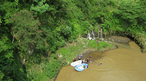
Progo River on:
[Wikipedia]
[Google]
[Amazon]

 The Progo River ( jv, Kali Praga, , ) is a river in southern central
 The Progo River ( jv, Kali Praga, , ) is a river in southern central
 Java
Java (; id, Jawa, ; jv, ꦗꦮ; su, ) is one of the Greater Sunda Islands in Indonesia. It is bordered by the Indian Ocean to the south and the Java Sea to the north. With a population of 151.6 million people, Java is the world's mos ...
, Indonesia
Indonesia, officially the Republic of Indonesia, is a country in Southeast Asia and Oceania between the Indian and Pacific oceans. It consists of over 17,000 islands, including Sumatra, Java, Sulawesi, and parts of Borneo and New Guine ...
.Rand McNally, ''The New International Atlas'', 1993. The river passes through two provinces; Central Java and Yogyakarta Special Region
The Special Region of Yogyakarta (; id, Daerah Istimewa (D.I.) Yogyakarta) is a provincial-level autonomous region of Indonesia in southern Java. It has also been known as the Special Territory of Yogyakarta.
It is bordered by the Indian Oce ...
. The source of the river is on the slopes of Mount Sindoro, Central Java.
Hydrology
The river runs to the southeast through the city of Magelang, then through the historicalKedu Plain
Kedu Plain, also known as Progo River valley, is the fertile volcanic plain that lies between the volcanoes Mount Sumbing and Mount Sundoro to the west, and Mount Merbabu and Mount Merapi to the east. It roughly corresponds to present-day Magela ...
passing near the well known Borobudur
Borobudur, also transcribed Barabudur ( id, Candi Borobudur, jv, ꦕꦤ꧀ꦝꦶꦧꦫꦧꦸꦝꦸꦂ, Candhi Barabudhur) is a 9th-century Mahayana Buddhist temple in Magelang Regency, not far from the town of Muntilan, in Central Java, Indone ...
, Mendut
Mendut is a ninth-century Buddhist temple, located in Mendut village, Mungkid sub-district, Magelang Regency, Central Java, Indonesia. The temple is located about three kilometres east from Borobudur. Mendut, Borobudur and Pawon, all of which are ...
, and Pawon
Pawon (known locally as Candi Pawon) is a Buddhist temple in Central Java, Indonesia.
History
Located between two other Buddhist temples, Borobudur ( to the northeast) and Mendut ( to the southwest), Pawon is connected with the other two temp ...
temples. Reaching the province of Yogyakarta the river forms a natural boundary between Sleman Regency
Sleman Regency () is an Indonesian regency ( id, Kabupaten) on the island of Java. It is located in the north of the Yogyakarta Special Administrative Region, Indonesia, and has an area of , with a population of 1,093,110 at the 2010 CensusBiro ...
, Kulon Progo Regency
Kulon Progo Regency ( jv, Kulon Praga, , ) is one of the four regencies within the Yogyakarta Special Region, Indonesia. It is located on the island of Java. The regency's name stems from the fact that it is situated to the west (in Javanese "ku ...
and Bantul Regency
Bantul ( jv, ꦧꦤ꧀ꦠꦸꦭ꧀; ) is a regency located in the Special Region of Yogyakarta, Indonesia. It is located on the island of Java. The regency's population was 911,503 at the 2010 Census, but has risen to 985,770 at the 2020 Census. Li ...
. The mouth of the river is located at Trisik beach on the southern shore of Java facing Indian Ocean
The Indian Ocean is the third-largest of the world's five oceanic divisions, covering or ~19.8% of the water on Earth's surface. It is bounded by Asia to the north, Africa to the west and Australia to the east. To the south it is bounded by t ...
.
Geography
The river flows in the southwest area of Java with predominantlytropical monsoon climate
An area of tropical monsoon climate (occasionally known as a sub-equatorial, tropical wet climate or a tropical monsoon and trade-wind littoral climate) is a tropical climate sub-type that corresponds to the Köppen climate classification category ...
(designated as ''Am'' in the Köppen-Geiger climate classification). The annual average temperature in the area is 24 °C. The warmest month is January, when the average temperature is around 27 °C, and the coldest is July, at 23 °C. The average annual rainfall is 2970 mm. The wettest month is January, with an average of 537 mm rainfall, and the driest is September, with 22 mm rainfall.
See also
*List of rivers of Java
List of rivers flowing in the island of Java, Indonesia.''Map of Indonesia''. Peta Indonesia. Wawasan Nusantara. CV. Indo Prima Sarana. Accessed 29 Juli 2017.
In alphabetical order
Mouth location
The following list groups the rivers by the dir ...
*List of rivers of Indonesia
This is a list of rivers in Indonesia
Indonesia, officially the Republic of Indonesia, is a country in Southeast Asia and Oceania between the Indian and Pacific oceans. It consists of over 17,000 islands, including Sumatra, Java, Sul ...
References
{{Coord, 7, 59, S, 110, 12, E, display=title, region:ID_type:river_source:GNS-enwiki Rivers of Central Java Rivers of Yogyakarta Rivers of Indonesia