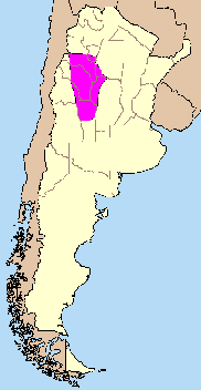
Pampean flat-slab segment on:
[Wikipedia]
[Google]
[Amazon]
 The Pampean flat-slab is the low angle subduction of
 The Pampean flat-slab is the low angle subduction of
 oceanic lithosphere
A lithosphere () is the rigid, outermost rocky shell of a terrestrial planet or natural satellite. On Earth, it is composed of the crust and the portion of the upper mantle that behaves elastically on time scales of up to thousands of years or ...
beneath Northern Argentina
Argentina (), officially the Argentine Republic ( es, link=no, República Argentina), is a country in the southern half of South America. Argentina covers an area of , making it the second-largest country in South America after Brazil, th ...
. The Pampean flat-slab is one of three flat slabs in South America, the other being the Peruvian flat-slab and the Bucaramanga flat-slab.
It is thought that the subduction of the Juan Fernández Ridge
The Juan Fernández Ridge is a volcanic island and seamount chain on the Nazca Plate. It runs in a west–east direction from the Juan Fernández hotspot to the Peru–Chile Trench at a latitude of 33° S near Valparaíso. The Juan Fernánde ...
, a chain of extinct volcanoes on the Nazca Plate, is the underlying cause of the Pampean flat-slab.
Effects
The shallowing of subducted slab beneath north-central Chile and Argentina is linked to a series of changes in volcanism and tectonics.Deformation of crust
The flat-slab has caused an uplift ofSierras Pampeanas
The Sierras Pampeanas (also called Central Sierras or Pampas Sierras) (English: Pampas Mountains) is a geographical region of Argentina.
The Sierras Pampeanas are a chain of mountains that rise sharply from the surrounding pampa region of ...
which begun first in the north and then moved southwards over millions of years. The oldest noted uplift episode associated with Pampean flat-slab is that of Sierra de Aconquija (27 °S) from 7.6 to 6 million years ago (Ma) in the Late Miocene epoch. This was followed by the uplift of massifs further south such as Sierra de Famatina 200px, Coat of arms of La Rioja featuring ''Cerro General Belgrano''
Sierra de Famatina is mountain range and massif in the Andes of the Argentine province of La Rioja
La Rioja () is an autonomous community and province in Spain, in the north ...
(29 °S) that rose 4.5 to 4.19 Ma ago. Next to rise was Sierra de Pocho (31 °S) 5.5 to 4.7 Ma ago followed by Sierra de San Luis
Sierra (Spanish for "mountain range" and "saw", from Latin '' serra'') may refer to the following:
Places Mountains and mountain ranges
* Sierra de Juárez, a mountain range in Baja California, Mexico
* Sierra de las Nieves, a mountain range i ...
(33 °S) 2.6 Ma Ago.
At latitude 33 °S deformation of the Andes proper has changed as the slab underneath has gradually shallowed. Thrust front propagation of the Principal Cordillera
Principal Cordillera ( es, Cordillera Principal) is the Andean mountain range that makes up the boundary between Central Chile and neighbouring areas of Argentina. It is also a continental divide between the Atlantic and the Pacific watersheds. ...
has increased five-fold in from 15-9 Ma ago to the Pliocene
The Pliocene ( ; also Pleiocene) is the epoch in the geologic time scale that extends from 5.333 million to 2.58Early Quaternary. Slightly east the
Frontal Cordillera
The Frontal Cordillera ( es, Cordillera Frontal) is a mountain range in western Argentina that forms part of the Andes. It extends in a north–south direction in the provinces of La Rioja
La Rioja () is an autonomous community and province i ...
was greatly uplifted 9 million years ago.
Volcanic gap
The Pampean flat-slab has also caused a lull in the volcanism in the Andes seen in the lack of modern volcanoes between the Central Andean Volcanic Zone and the Southern Andean Volcanic Zone. As the flat slab migrated from west to east under South America, so did volcanic activity, until it vanished 1.9 Ma ago, about from the Pacific, far to the east of ordinary subduction volcanism. Migration of the volcanic activity to the east meant that in thePrincipal Cordillera
Principal Cordillera ( es, Cordillera Principal) is the Andean mountain range that makes up the boundary between Central Chile and neighbouring areas of Argentina. It is also a continental divide between the Atlantic and the Pacific watersheds. ...
magmatic activity ended as early as 8.6 Ma ago.
References
{{reflist Andean Volcanic Belt Geology of Atacama Region Geology of Catamarca Province Geology of Córdoba Province, Argentina Geology of Coquimbo Region Geology of La Rioja Province, Argentina Geology of San Juan Province, Argentina Geology of San Luis Province Geology of Valparaíso Region Geology of the Andes Subduction