Oryahovo Heights on:
[Wikipedia]
[Google]
[Amazon]

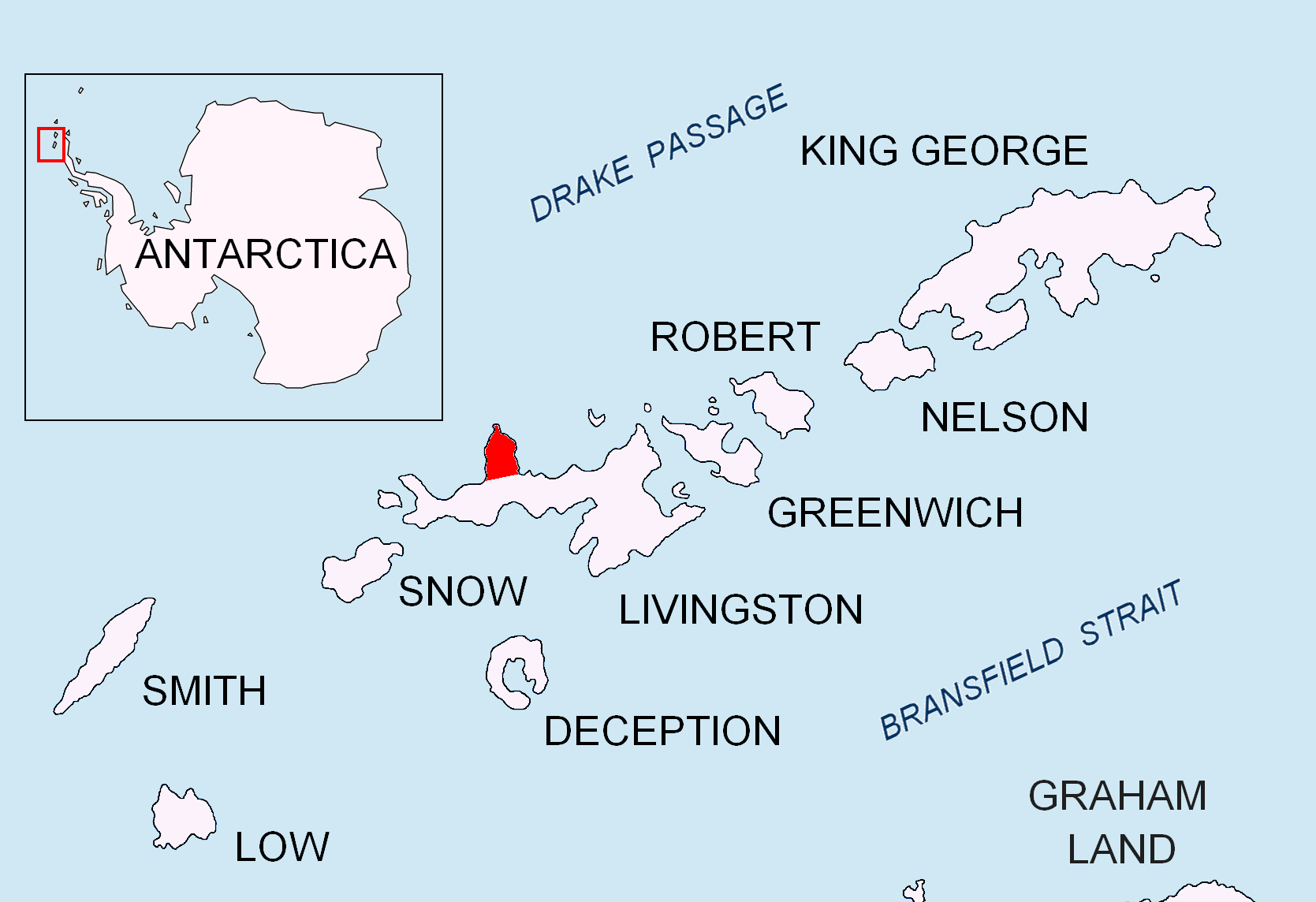
 Oryahovo Heights (Oryahovski Vazvisheniya \o-'rya-hov-ski v&-zvi-'she-ni-ya\) are the ice-covered heights of elevation 340 m extending 6 km in north-south direction in central and eastern
''The geology of Livingston Island ''.
Scientific Report No. 47. British Antarctic Survey, 1963. Figure 1 They are named after the town of
Antarctica: Livingston Island and Greenwich, Robert, Snow and Smith Islands
Scale 1:120000 topographic map. Troyan: Manfred Wörner Foundation, 2009.
Antarctic Digital Database (ADD).
Scale 1:250000 topographic map of Antarctica. Scientific Committee on Antarctic Research (SCAR). Since 1993, regularly upgraded and updated. * L.L. Ivanov. Antarctica: Livingston Island and Smith Island. Scale 1:100000 topographic map. Manfred Wörner Foundation, 2017.
Oryahovo Heights.
SCAR
Bulgarian Antarctic Gazetteer.
basic data
in English)
 Oryahovo Heights (Oryahovski Vazvisheniya \o-'rya-hov-ski v&-zvi-'she-ni-ya\) are the ice-covered heights of elevation 340 m extending 6 km in north-south direction in central and eastern
 Ioannes Paulus II Peninsula
Ioannes Paulus II Peninsula ( bg, Полуостров Йоан Павел II, Poluostrov Yoan Pavel II, ) is an ice-covered peninsula on the north coast of Livingston Island in the South Shetland Islands, Antarctica that is bounded by Hero Bay t ...
, Livingston Island
Livingston Island (Russian name ''Smolensk'', ) is an Antarctic island in the Southern Ocean, part of the South Shetlands Archipelago, a group of Antarctic islands north of the Antarctic Peninsula. It was the first land discovered south of 60 ...
in the South Shetland Islands
The South Shetland Islands are a group of Antarctic islands with a total area of . They lie about north of the Antarctic Peninsula, and between southwest of the nearest point of the South Orkney Islands. By the Antarctic Treaty of 195 ...
, Antarctica
Antarctica () is Earth's southernmost and least-populated continent. Situated almost entirely south of the Antarctic Circle and surrounded by the Southern Ocean, it contains the geographic South Pole. Antarctica is the fifth-largest contine ...
. They are linked to Snow Peak to the southeast by two saddles separated by the small ice dome of Casanovas Peak described by Àlex Simón i Casanovas
Àlex Simon i Casanovas (born 1960 in Gràcia neighbourhood of Barcelona) is a Catalonian mountain guide, climbing teacher, outdoor instructor and logistic. He has climbed in the Pyrenees, Alps and the Dolomites, as well as in the United State ...
from the Spanish Antarctic Programme in the 2000/01 austral summer. The heights were visited by a field party from the British base camp Station P
Station P was a British base camp at the head of Mateev Cove on the east side of Hannah Point, Livingston Island in the South Shetland Islands, Antarctica that supported survey, geology and biology field work from 29 December 1957 until 15 March ...
during the summer season 1957/58.G.J. Hobbs. Map showing the physiography, geological station numbers and the survey routes on Livingston Island. In''The geology of Livingston Island ''.
Scientific Report No. 47. British Antarctic Survey, 1963. Figure 1 They are named after the town of
Oryahovo
Oryahovo ( bg, Оряхово ) is a port city in northwestern Bulgaria, part of Vratsa Province. It is located in a hilly area on the right bank of the Danube, just east of the mouth of the river Ogosta, a few more kilometres downstream from ...
in northwestern Bulgaria
Bulgaria (; bg, България, Bǎlgariya), officially the Republic of Bulgaria,, ) is a country in Southeast Europe. It is situated on the eastern flank of the Balkans, and is bordered by Romania to the north, Serbia and North Macedon ...
.
Location
The heights are centered at (British mapping in 1963 and 1968, Bulgarian in 2009).Maps
* L.L. Ivanov et al. Antarctica: Livingston Island and Greenwich Island, South Shetland Islands. Scale 1:100000 topographic map. Sofia: Antarctic Place-names Commission of Bulgaria, 2005. * L.L. IvanovAntarctica: Livingston Island and Greenwich, Robert, Snow and Smith Islands
Scale 1:120000 topographic map. Troyan: Manfred Wörner Foundation, 2009.
Antarctic Digital Database (ADD).
Scale 1:250000 topographic map of Antarctica. Scientific Committee on Antarctic Research (SCAR). Since 1993, regularly upgraded and updated. * L.L. Ivanov. Antarctica: Livingston Island and Smith Island. Scale 1:100000 topographic map. Manfred Wörner Foundation, 2017.
Notes
References
Oryahovo Heights.
SCAR
Composite Antarctic Gazetteer
The Composite Gazetteer of Antarctica (CGA) of the Scientific Committee on Antarctic Research (SCAR) is the authoritative international gazetteer containing all Antarctic toponyms published in national gazetteers, plus basic information about t ...
Bulgarian Antarctic Gazetteer.
Antarctic Place-names Commission
The Antarctic Place-names Commission was established by the Bulgarian Antarctic Institute in 1994, and since 2001 has been a body affiliated with the Ministry of Foreign Affairs of Bulgaria.
The Commission approves Bulgarian place names in ...
. (details in Bulgarianbasic data
in English)
External linksOryahovo Heights.
Copernix satellite image
Landforms of Livingston Island
{{LivingstonIsland-geo-stub