Muruntau gold deposit on:
[Wikipedia]
[Google]
[Amazon]


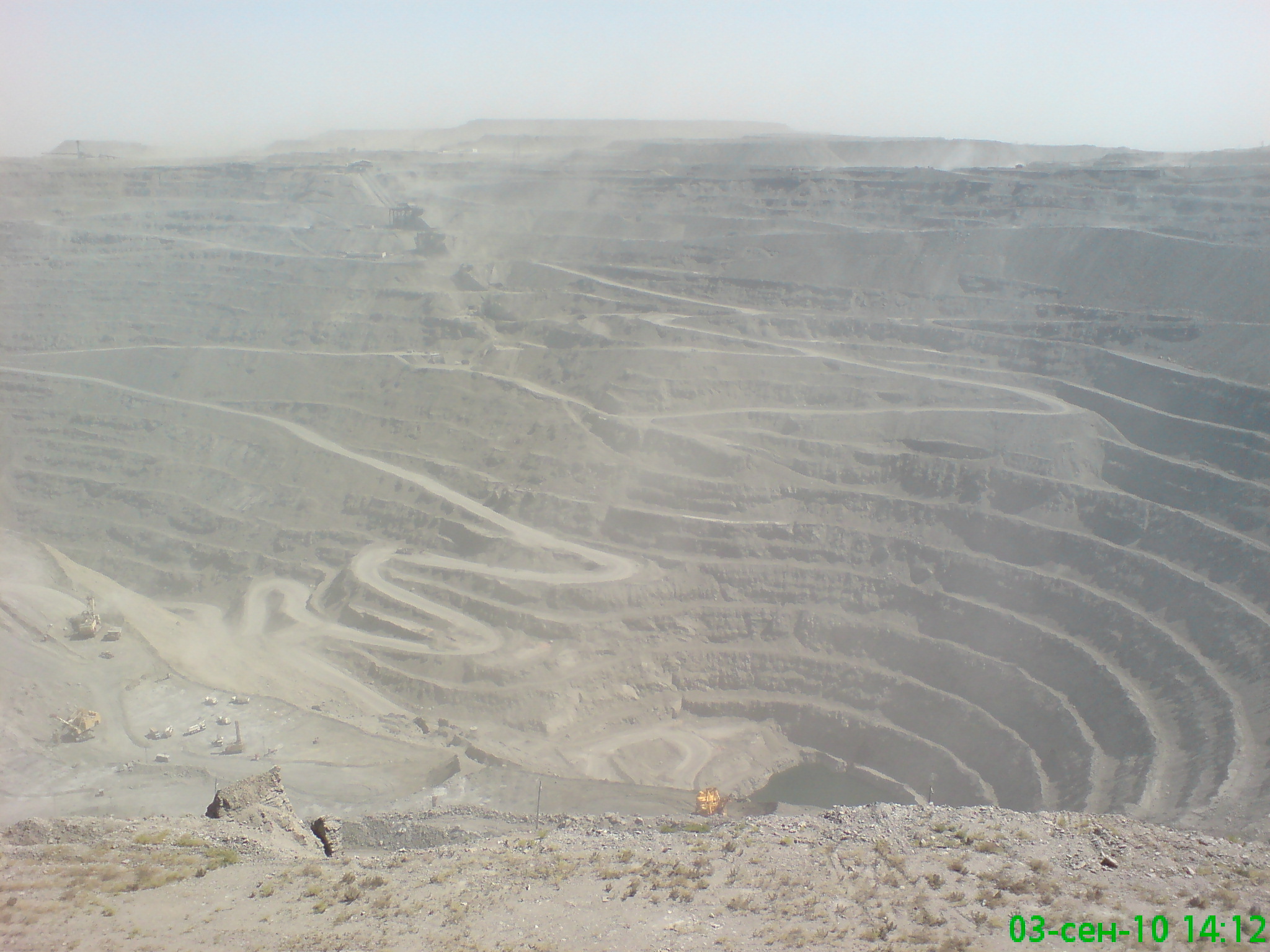
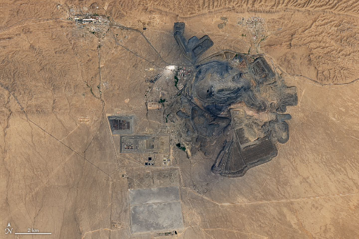
 The Muruntau gold deposit is situated in the Qizilqum Desert of

Uzbekistan
Uzbekistan (, ; uz, Ozbekiston, italic=yes / , ; russian: Узбекистан), officially the Republic of Uzbekistan ( uz, Ozbekiston Respublikasi, italic=yes / ; russian: Республика Узбекистан), is a doubly landlocked co ...
. It is being mined in the world's largest open-pit
Open-pit mining, also known as open-cast or open-cut mining and in larger contexts mega-mining, is a surface mining technique of extracting rock or minerals from the earth from an open-air pit, sometimes known as a borrow.
This form of mining ...
gold mine Gold Mine may refer to:
* Gold Mine (board game)
*Gold Mine (Long Beach), an arena
*"Gold Mine", a song by Joyner Lucas from the 2020 album ''ADHD
Attention deficit hyperactivity disorder (ADHD) is a neurodevelopmental disorder characteri ...
with production believed to be of the order of two million ounces per annum. The open pit measures about 3.5 by 2.5 km and extends to a depth of 560m (2012). The gold ore resource in the Muruntau deposit, including production, is about 170 million ounces of gold. The mine is owned and operated by Uzbekistan state-owned Navoi Mining and Metallurgy Combinat.
The giant Muruntau Gold deposit was discovered in 1958. The area was a source of turquoise
Turquoise is an opaque, blue-to-green mineral that is a hydrated phosphate of copper and aluminium, with the chemical formula . It is rare and valuable in finer grades and has been prized as a gemstone and ornamental stone for thousands of year ...
since the days of the Silk Road. It was not until the 1950s, however, that the Muruntau area was systematically explored. A large gold and arsenic geochemical anomaly, detected during systematic geochemical sampling and geological mapping of the area indicated the Muruntau deposit. Auriferous quartz veins were subsequently found in surface exposures at the site of the current open pit. Mining commenced on the deposit in 1967, and production has been continuous ever since.
Tectonic setting
The Kyzyl Kum area is underlain by three main tectonic units. The oldest, basement, consists of metamorphosed and foldedLower Palaeozoic
The Paleozoic (or Palaeozoic) Era is the earliest of three geologic eras of the Phanerozoic Eon.
The name ''Paleozoic'' ( ;) was coined by the British geologist Adam Sedgwick in 1838
by combining the Greek words ''palaiós'' (, "old") and ' ...
carbonaceous and sulphidic clastic rock referred to as the Besopan Formation. The Besopan Formation was metamorphosed and deformed during the Lower Palaeozoic Caledonian orogeny
The Caledonian orogeny was a mountain-building era recorded in the northern parts of the British Isles, the Scandinavian Mountains, Svalbard, eastern Greenland and parts of north-central Europe. The Caledonian orogeny encompasses events that ...
.
After erosion and exhumation it became basement to an unconformable unit of Devonian to Early Triassic
The Early Triassic is the first of three epochs of the Triassic Period of the geologic timescale. It spans the time between Ma and Ma (million years ago). Rocks from this epoch are collectively known as the Lower Triassic Series, which is a un ...
carbonate and clastic sediments and volcanic rocks.
Tectonics
Caledonian (Silurian) deformation
The Kyzyl Kum area basement is strongly folded andpelitic
A pelite (Greek: ''pelos'', "clay") or metapelite is a metamorphosed fine-grained sedimentary rock, i.e. mudstone or siltstone. The term was earlier used by geologists to describe a clay-rich, fine-grained clastic sediment or sedimentary rock ...
rocks have a well-developed axial planar cleavage. Isoclinal folds with east-striking axial plane
The transverse plane (also known as the horizontal plane, axial plane and transaxial plane) is an anatomical plane that divides the body into superior and inferior sections. It is perpendicular to the coronal and sagittal planes.
List of cli ...
s become overturned to the north. Such isoclinal folding is interpreted to have occurred prior to deposition of the basement, which exhibits open folds with vertical axial planes.
Metamorphic grade
Metamorphism is the transformation of existing rock (the protolith) to rock with a different mineral composition or texture. Metamorphism takes place at temperatures in excess of , and often also at elevated pressure or in the presence of che ...
of the basement does not exceed greenschist facies
Greenschists are metamorphic rocks that formed under the lowest temperatures and pressures usually produced by regional metamorphism, typically and 2–10 kilobars (). Greenschists commonly have an abundance of green minerals such as chlorite, ...
over much of the region. Rubidium - Strontium dating of metamorphic micas has indicated a Caledonian (Early Devonian) cooling age of 401 ± 11 million years.
Late Carboniferous deformation
There is evidence of a deformation event during theHercynian orogeny
The Variscan or Hercynian orogeny was a geologic mountain-building event caused by Late Paleozoic continental collision between Euramerica (Laurussia) and Gondwana to form the supercontinent of Pangaea.
Nomenclature
The name ''Variscan'', comes f ...
(late Carboniferous) in this region. North of Muruntau, Devonian and Carboniferous carbonate rocks are thrust
Thrust is a reaction force described quantitatively by Newton's third law. When a system expels or accelerates mass in one direction, the accelerated mass will cause a force of equal magnitude but opposite direction to be applied to that sys ...
over the top of the older basement rocks. Therefore, the age of this thrust is Carboniferous or younger.
A thrusting event at this time helps to explain the change at the top of the Carboniferous (in the Karatau Range) from shallow marine to terrestrial.
Permo-Triassic deformation
A major Permo-Triassic deformation event in the Karatau Range occurs north of Muruntau as well. This event is synchronous with the major unconformity above. The main mechanism of this event is the giant Karatau Fault, which has right-lateral displacement of and related steeply-plunging Z-shaped folds. Outcrops of the basement throughout the region are elongate in the direction of strike-slip faulting, northwest.Late Mesozoic and Tertiary deformation
Open folds which are post-Tertiary in age are superimposed on the Hercynian deformation. These folds occur in Tertiary exposures approximately 50 km to the south-west of the Muruntau deposit. Furthermore, a of right-lateral movement occurred along the Karatau Fault during the late Mesozoic and early Tertiary.References
* {{coord, 41, 29, 54, N, 64, 34, 18, E, type:landmark_source:kolossus-frwiki, display=title Gold mines in Uzbekistan Geology of Uzbekistan Gold mines in the Soviet Union