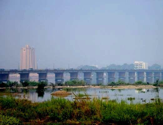
Martyrs Bridge (Bamako) on:
[Wikipedia]
[Google]
[Amazon]
 The Martyrs Bridge (Pont des martyrs) of
3è pont de Bamako : Le Chantier se Précise à l'Horizon
. L'Essor, 21 May 2007.
 The Martyrs Bridge (Pont des martyrs) of
 Bamako
Bamako ( bm, ߓߡߊ߬ߞߐ߬ ''Bàmakɔ̌'', ff, 𞤄𞤢𞤥𞤢𞤳𞤮 ''Bamako'') is the Capital city, capital and largest city of Mali, with a 2009 population of 1,810,366 and an estimated 2022 population of 2.81 million. It is located on t ...
, Mali
Mali (; ), officially the Republic of Mali,, , ff, 𞤈𞤫𞤲𞥆𞤣𞤢𞥄𞤲𞤣𞤭 𞤃𞤢𞥄𞤤𞤭, Renndaandi Maali, italics=no, ar, جمهورية مالي, Jumhūriyyāt Mālī is a landlocked country in West Africa. Mali ...
connects the older sections of the city to its suburbs on the south shore of the Niger River
The Niger River ( ; ) is the main river of West Africa, extending about . Its drainage basin is in area. Its source is in the Guinea Highlands in south-eastern Guinea near the Sierra Leone border. It runs in a crescent shape through ...
. One of three road bridges across the Niger at Bamako, it is also known as the "Old Bridge". Opened in 1957 when Mali was under French colonial rule, it was renamed the Martyrs Bridge in 1991 following the deaths of protesters against the rule of Moussa Traoré
Moussa Traoré (25 September 1936 – 15 September 2020) was a Malian soldier, politician, and dictator who was President of Mali from 1968 to 1991. As a Lieutenant, he led the military ousting of President Modibo Keïta in 1968. Thereafter he ...
. Martyrs Bridge connects two of the main avenues of the city. ''Avenue Fleuve'' (also known as ''Avenue Modibo Keita''), a broad boulevard enclosing the Square Lamumba which runs north towards the Presidential palace. From the south of the bridge runs Avenue de l'Unite Africain, the major route from the city centre south to Bamako-Senou Airport.
Other crossings
In 1982 a second road bridge, theKing Fahd Bridge
The King Fahd Bridge (Pont Roi Fahd) of Bamako, Mali connects the older sections of the Malian capital to its broad suburbs on the south shore of the Niger River.
One of three road bridges across the Niger at Bamako, it is also known as the "New ...
, was opened just 500 meters upstream. Both bridges connect the central city neighborhood of Commune III with Badalabougou.
Prior to the 1950s, the only crossing of the Niger at Bamako was at the Sotuba Causeway, 8 kilometers downstream from the city, which is a low water crossing of cut stone at the location of a natural rapids. The next all season crossing downstream is at the Markala Dam
Markala is a commune in Mali's Ségou Region on the Niger River 35 km down stream from the town of Ségou. The commune contains 30 villages in an area of 318 square kilometers and in 2009 had a population of 45,961.. Mali's primary irrigation ...
, over 200 kilometers east northeast past Segou, which until recently relied on ferry transport to cross one arm of the Niger. The next road bridge to cross the Niger river downstream of Markala
Markala is a commune in Mali's Ségou Region on the Niger River 35 km down stream from the town of Ségou. The commune contains 30 villages in an area of 318 square kilometers and in 2009 had a population of 45,961.. Mali's primary irrigation ...
is at Gao
Gao , or Gawgaw/Kawkaw, is a city in Mali and the capital of the Gao Region. The city is located on the River Niger, east-southeast of Timbuktu on the left bank at the junction with the Tilemsi valley.
For much of its history Gao was an impor ...
, Mali
Mali (; ), officially the Republic of Mali,, , ff, 𞤈𞤫𞤲𞥆𞤣𞤢𞥄𞤲𞤣𞤭 𞤃𞤢𞥄𞤤𞤭, Renndaandi Maali, italics=no, ar, جمهورية مالي, Jumhūriyyāt Mālī is a landlocked country in West Africa. Mali ...
. A Chinese funded third road bridge, downstream on the east end of Bamako, is in the planning stage.. L'Essor, 21 May 2007.
References
* Pascal James Imperato. Historical Dictionary of Mali. Scarecrow Press/ Metuchen. NJ - London (1986) *Velton, Ross. Mali: The Bradt Travel Guide. Guilford, Connecticut: Globe Pequot Press, 2000. pp. 101–122 {{Coord, 12, 37, 49, N, 7, 59, 31, W, type:landmark, display=title Bridges in Mali Buildings and structures in Bamako Crossings of the Niger River Bridges completed in 1957