Lisburn Road on:
[Wikipedia]
[Google]
[Amazon]
 Lisburn Road is a main arterial route linking

 Notable landmarks along Lisburn Road include:
* Drumglass Park
*
 Lisburn Road is a main arterial route linking
 Belfast
Belfast ( , ; from ga, Béal Feirste , meaning 'mouth of the sand-bank ford') is the capital and largest city of Northern Ireland, standing on the banks of the River Lagan on the east coast. It is the 12th-largest city in the United Kingdom ...
and Lisburn
Lisburn (; ) is a city in Northern Ireland. It is southwest of Belfast city centre, on the River Lagan, which forms the boundary between County Antrim and County Down. First laid out in the 17th century by English and Welsh settlers, with ...
, Northern Ireland
Northern Ireland ( ga, Tuaisceart Éireann ; sco, label=Ulster Scots dialect, Ulster-Scots, Norlin Airlann) is a part of the United Kingdom, situated in the north-east of the island of Ireland, that is #Descriptions, variously described as ...
.
The Lisburn Road is now an extension of the " Golden Mile" with many shops, boutiques, wine bars, restaurants and coffee houses. The road runs almost parallel to the Malone Road
The Malone Road () is a radial road in Belfast, Northern Ireland, leading from the university quarter southwards to the affluent suburbs of Malone and Upper Malone, each a separate electoral ward. The road runs parallel to the Lisburn Road and i ...
, the two being joined by many side roads. It is a busy traffic route without much strong architectural character. Most of the housing is made up of red-brick terraces, some with alterations. Some buildings along the road, however, are considered to be architecturally important and interesting.Larmour, P. 1991. "The Architectural Heritage of Malone and Stranmillis." Ulster Architectural Heritage Society.
Lisburn Road itself begins at the nearby Bradbury Place and runs to Balmoral Avenue, beyond which it becomes Upper Lisburn Road. The Upper Lisburn Road extends south to reach Finaghy
Finaghy (
or ; ) is an electoral ward in the Balmoral district of Belfast City Council, Northern Ireland. It is based on the townland of Ballyfinaghy ().Dunmurry
Dunmurry (; ) is an urban townland in Belfast, Northern Ireland. Dunmurry is in the Collin electoral ward for the local government district of Belfast City Council.
History
Until the end of the 18th century, Dunmurry was largely an agricul ...
it becomes Queensway, before finally becoming the Belfast Road in Lisburn
Lisburn (; ) is a city in Northern Ireland. It is southwest of Belfast city centre, on the River Lagan, which forms the boundary between County Antrim and County Down. First laid out in the 17th century by English and Welsh settlers, with ...
.
History
The first record of the development of the Lisburn Road was when a property developer offered land for development 'West of the Lisburn Road' on 6 April 1813. His advert was placed in ''The News Letter
The ''News Letter'' is one of Northern Ireland's main daily newspapers, published from Monday to Saturday. It is the world's oldest English-language general daily newspaper still in publication, having first been printed in 1737.
The newspape ...
'' on that date. The track that initially existed here developed and expanded, until pressure grew for a faster turnpike road to Dublin
Dublin (; , or ) is the capital and largest city of Ireland. On a bay at the mouth of the River Liffey, it is in the province of Leinster, bordered on the south by the Dublin Mountains, a part of the Wicklow Mountains range. At the 2016 ...
, to avoid the Malone Road hills and valleys. During 1817–1819 this road improvement scheme was implemented. The post office and toll booth stood, conveniently, at Shaftesbury Square
Shaftesbury Square is in Belfast, Northern Ireland at the southern end of Great Victoria Street and Dublin road, with the adjoining streets of Lisburn Road and the Donegall Road converging at this junction. It is in the area commonly known as ...
, and presumably served both turnpike roads. At the top of Tate's Avenue, on the Lisburn Road side of the junction a second booth was in existence in 1857. One year later the toll business was abandoned, as the trains had taken over. Shopping habits have changed and the shopping population has moved from Shaftesbury Square, along the Lisburn Road.
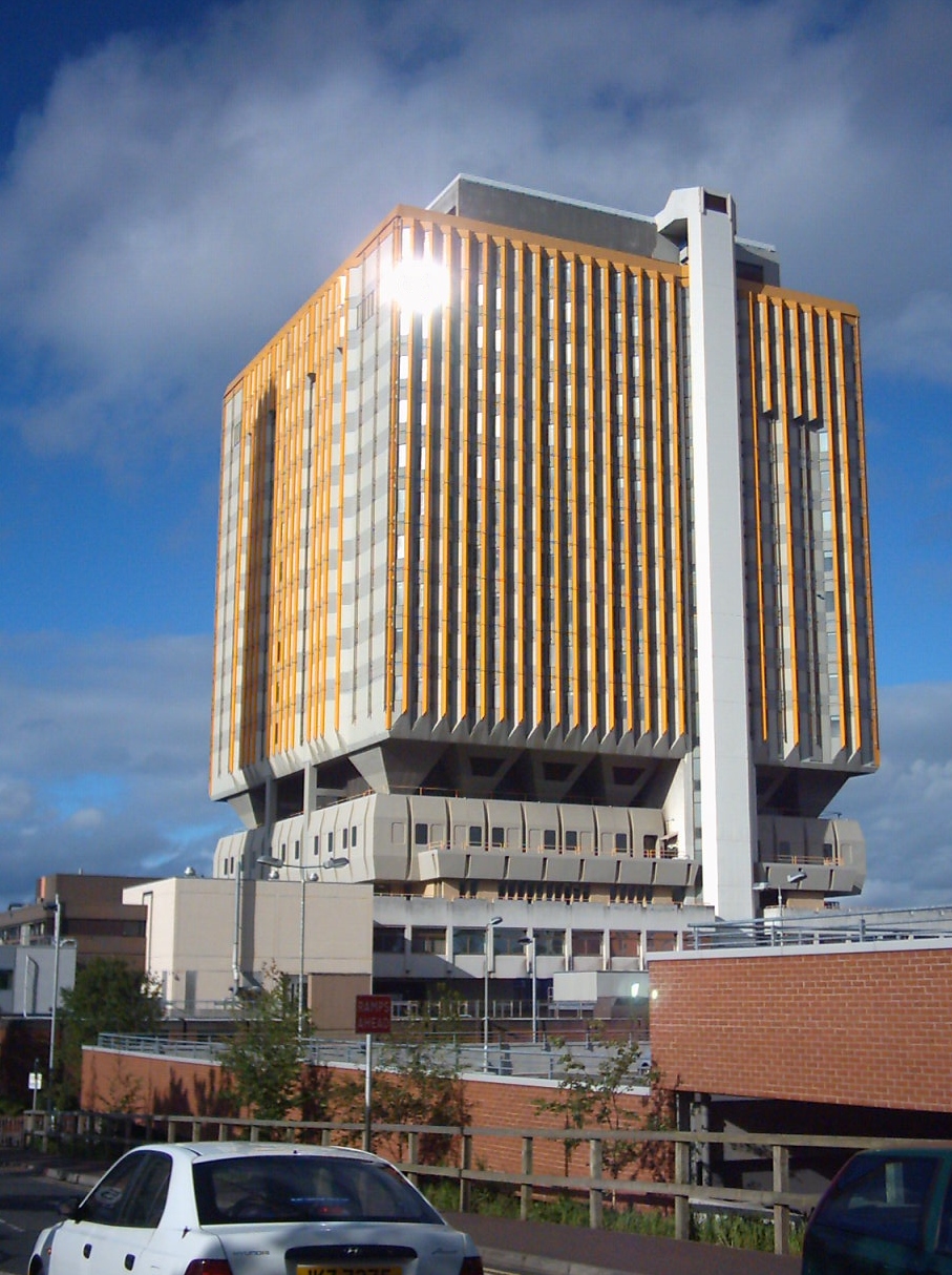
Lisburn Road attracted shops and the nearby Malone Road was left residential.Weatherall. 2002. ''South Belfast Terrace and Villa.'' Cottage Publications. Queen's University is nearby, and there are a high number of expensive shops and restaurants, most of which are located at the upper end of the road. The Belfast City Hospital
The Belfast City Hospital ( ga, Ospidéal Chathair Bhéal Feirste) in Belfast, Northern Ireland, is a 900-bed modern university teaching hospital providing local acute services and key regional specialities. Its distinctive orange tower block d ...
and the Queen's University Medical Biological Centre are also located on the road.
Racist attacks
In June 2009, having had their windows broken and deaths threats made against them, twentyRomanian
Romanian may refer to:
*anything of, from, or related to the country and nation of Romania
** Romanians, an ethnic group
**Romanian language, a Romance language
***Romanian dialects, variants of the Romanian language
**Romanian cuisine, traditiona ...
Romani
Romani may refer to:
Ethnicities
* Romani people, an ethnic group of Northern Indian origin, living dispersed in Europe, the Americas and Asia
** Romani genocide, under Nazi rule
* Romani language, any of several Indo-Aryan languages of the Roma ...
families were ejected from their homes in Lisburn Road. Up to 115 people, including women and children, were forced to seek refuge in a local church hall after being attacked. They were later moved by the authorities to a safer location.
As a result of petty thefts gypsies were told to leave, they spent one night at QUB Elms Village at a cost of 40 pounds per room.
Following the arrest of three local youths in relation to the attacks, the church where the Romani people had been given shelter was badly vandalised. Niall Colton and Kevin Briggs, who both attended QUB at the time of the attack, received police cautions after admitting vandalism of the Church. Police however stated that the vandalism was not racially motivated.
Landmarks

 Notable landmarks along Lisburn Road include:
* Drumglass Park
*
Notable landmarks along Lisburn Road include:
* Drumglass Park
*Belfast City Hospital
The Belfast City Hospital ( ga, Ospidéal Chathair Bhéal Feirste) in Belfast, Northern Ireland, is a 900-bed modern university teaching hospital providing local acute services and key regional specialities. Its distinctive orange tower block d ...
* The Samaritan Hospital, Belfast
*Methodist College Belfast
God with us
, established = 1865
, type = Voluntary grammar
, religion = Interdenominational
, principal = Jenny Lendrum
, chair_label = Chairwoman
, chair = Revd. Dr Janet Unsworth
, founder ...
(which also fronts the Malone Road
The Malone Road () is a radial road in Belfast, Northern Ireland, leading from the university quarter southwards to the affluent suburbs of Malone and Upper Malone, each a separate electoral ward. The road runs parallel to the Lisburn Road and i ...
)
*Belfast Chinese Christian Church
* Windsor Park football ground
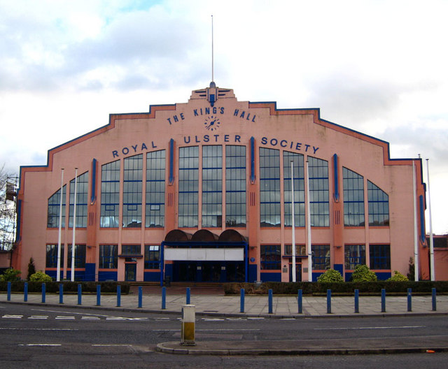
*King's Hall, Belfast
The King's Hall was a multi-purpose venue located in Belfast, Northern Ireland. The King's Hall consisted of 6 event venues. The King's Hall is owned by the Royal Ulster Agricultural Society (RUAS) (previously the North East Agricultural Associ ...
(Former Exhibition and Concert Venue)
*Belfast Hypnotherapy Centre
Churches
*Windsor Presbyterian Church *Saint Nicholas' Church of Ireland, built in 1901 * St Thomas' Church of Ireland *Lisburn Road Methodist Church, designed in 1906Lamour, P. 1987. ''Belfast An Illustrated Architectural Guide.'' Friar's Bush Press, . *Ulsterville Congregation Presbyterian *St. Brigids Church, Diocese of Down and Connor, Derryvolgie AvenueWildlife
A sparrowhawk (''Accipiter nisus
The Eurasian sparrowhawk (''Accipiter nisus''), also known as the northern sparrowhawk or simply the sparrowhawk, is a small bird of prey in the family Accipitridae. Adult male Eurasian sparrowhawks have bluish grey upperparts and orange-barred ...
'') catching a sparrow (''Passer domesticus
The house sparrow (''Passer domesticus'') is a bird of the sparrow family Passeridae, found in most parts of the world. It is a small bird that has a typical length of and a mass of . Females and young birds are coloured pale brown and grey, an ...
'') has been recorded from the Lisburn Road.
Railway stations
*Adelaide
Adelaide ( ) is the capital city of South Australia, the state's largest city and the fifth-most populous city in Australia. "Adelaide" may refer to either Greater Adelaide (including the Adelaide Hills) or the Adelaide city centre. The dem ...
* Balmoral
* City Hospital
Deaf and Dumb Institute
The Deaf and Dumb Institute was built in 1845 and demolished in 1965, the site is now occupied by Queen's Medical Biology Centre. It was a well-designed and well built building.Nesbitt, N. 1982 ''The Changing Face of Belfast.'' Ulster Museum, Belfast. Publication No. 183References
External links
* {{coord, 54.57007, N, 5.96412, W, type:landmark_region:GB, display=title Streets in Belfast Roads in Northern Ireland Shopping streets in the United Kingdom