Le Maire Strait on:
[Wikipedia]
[Google]
[Amazon]


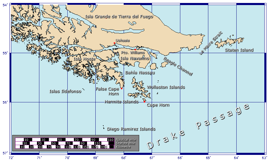
 The Le Maire Strait (''Estrecho de le Maire'') (also the Straits Lemaire) is a sea passage between
''Magellanic Penguin'', GlobalTwitcher.com, ed. N. Stromberg
* Michael A. Morris. 1989. ''The Strait of Magellan'', page 90 of 237 pages
Satellite image from Google Maps
Landforms of Tierra del Fuego Province, Argentina Straits of Argentina 1616 in the Dutch Empire Maritime history of the Dutch Republic {{TierradelFuegoAR-geo-stub


Isla de los Estados
Isla de los Estados (English: Staten Island, from the Dutch ''Stateneiland'') is an Argentine island that lies off the eastern extremity of Tierra del Fuego, from which it is separated by the Le Maire Strait. It was named after the Netherlands ...
and the eastern extremity of the Argentine
Argentines (mistakenly translated Argentineans in the past; in Spanish (masculine) or (feminine)) are people identified with the country of Argentina. This connection may be residential, legal, historical or cultural. For most Argentines, s ...
portion of Tierra del Fuego
Tierra del Fuego (, ; Spanish for "Land of the Fire", rarely also Fireland in English) is an archipelago off the southernmost tip of the South American mainland, across the Strait of Magellan. The archipelago consists of the main island, Isla ...
.
History
Jacob Le Maire
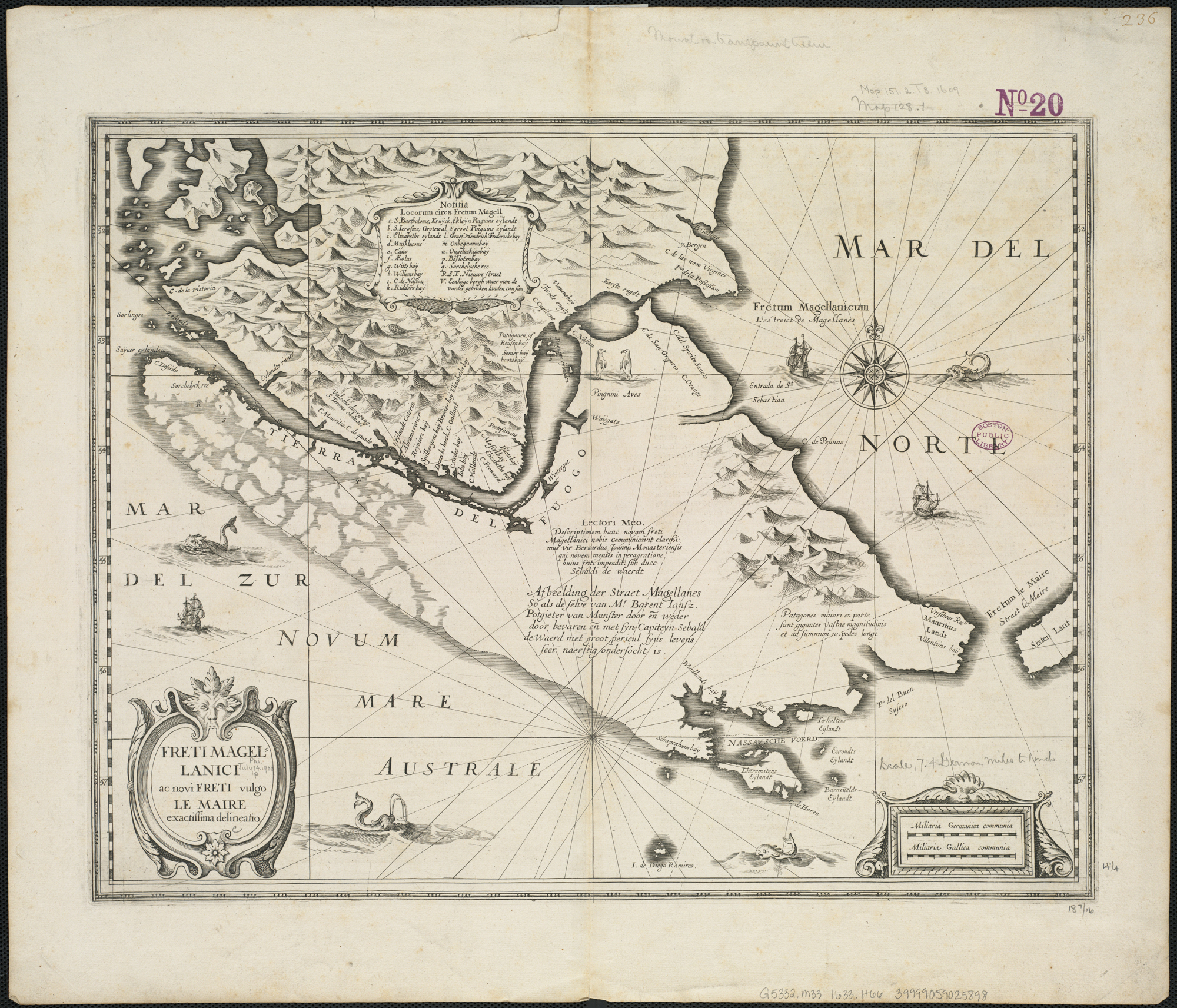
Jacob Le Maire (c. 1585 – 22 December 1616) was a Dutch mariner who circumnavigated the earth in 1615 and 1616. The strait between Tierra del Fuego and Isla de los Estados was named the Le Maire Strait in his honour, though not without controver ...
and Willem Schouten
Willem Cornelisz Schouten ( – 1625) was a Dutch navigator for the Dutch East India Company. He was the first to sail the Cape Horn route to the Pacific Ocean.
Biography
Willem Cornelisz Schouten was born in c. 1567 in Hoorn, Holland, Seve ...
discovered the strait in 1616, while attempting to find a navigation link between the Atlantic
The Atlantic Ocean is the second-largest of the world's five oceans, with an area of about . It covers approximately 20% of Earth's surface and about 29% of its water surface area. It is known to separate the " Old World" of Africa, Europe an ...
and Pacific Ocean
The Pacific Ocean is the largest and deepest of Earth's five oceanic divisions. It extends from the Arctic Ocean in the north to the Southern Ocean (or, depending on definition, to Antarctica) in the south, and is bounded by the continen ...
s, and shortly before their discovery of Cape Horn
Cape Horn ( es, Cabo de Hornos, ) is the southernmost headland of the Tierra del Fuego archipelago of southern Chile, and is located on the small Hornos Island. Although not the most southerly point of South America (which are the Diego Ramírez ...
. The strait was named in honor of Le Maire. The Le Maire Strait has been Argentine controlled, but has been a historical access route for Chilean vessels, under international maritime law
Admiralty law or maritime law is a body of law that governs nautical issues and private maritime disputes. Admiralty law consists of both domestic law on maritime activities, and private international law governing the relationships between priva ...
. The stormy weather and strong currents that the waters around Cape Horn are so famous for also affect the strait. To avoid the risk of being blown against the shore of Tierra del Fuego, sailing ships often instead favour going around to the east of Isla de los Estados.
The Magellanic penguin
The Magellanic penguin (''Spheniscus magellanicus'') is a South American penguin, breeding in coastal Patagonia, including Argentina, Chile, and the Falkland Islands, with some migrating to Brazil and Uruguay, where they are occasionally seen a ...
is found in the Le Maire Strait; this penguin has a breeding colony
In modern parlance, a colony is a territory subject to a form of foreign rule. Though dominated by the foreign colonizers, colonies remain separate from the administration of the original country of the colonizers, the ''metropole, metropolit ...
on Isla de los Estados
Isla de los Estados (English: Staten Island, from the Dutch ''Stateneiland'') is an Argentine island that lies off the eastern extremity of Tierra del Fuego, from which it is separated by the Le Maire Strait. It was named after the Netherlands ...
, the location of one of the more southerly Atlantic
The Atlantic Ocean is the second-largest of the world's five oceans, with an area of about . It covers approximately 20% of Earth's surface and about 29% of its water surface area. It is known to separate the " Old World" of Africa, Europe an ...
breeding colonies of the Magellanic penguin.C. Michael Hogan. 2008
See also
* Garcia de Nodal expeditionLine notes
References
* C. Michael Hogan. 2008''Magellanic Penguin'', GlobalTwitcher.com, ed. N. Stromberg
* Michael A. Morris. 1989. ''The Strait of Magellan'', page 90 of 237 pages
External links
Satellite image from Google Maps
Landforms of Tierra del Fuego Province, Argentina Straits of Argentina 1616 in the Dutch Empire Maritime history of the Dutch Republic {{TierradelFuegoAR-geo-stub