Giambattista Nolli on:
[Wikipedia]
[Google]
[Amazon]

 Giambattista Nolli (or Giovanni Battista) pril 9, 1701 – July 3, 1756 was an Italian
'The New Plan of Rome'
By James Tice and Erik Steiner, University of Oregon Press, USA, 2006.
'The Nolli Plan of Rome: Facsimile'
Full-size facsimile portfolio of the original 19 sheets 56 cm x 81 cm 2"x 32"with 12pp intro. by Allen Ceen; J. H. Aronson Publisher, Highmount, NY 12441, 1st Ed. 1984, 2nd Ed. 1991.
The interactive Nolli Map
b
B-Open Solutions
Roma Leggendaria
Nolli - Navigate Rome in 1748
the Nolli Map for iOS
a website dedicated to the Nolli map
{{DEFAULTSORT:Nolli, Giambattista 1701 births 1756 deaths 18th-century Italian architects Cartography by city People from Como

 Giambattista Nolli (or Giovanni Battista) pril 9, 1701 – July 3, 1756 was an Italian
 architect
An architect is a person who plans, designs and oversees the construction of buildings. To practice architecture means to provide services in connection with the design of buildings and the space within the site surrounding the buildings that h ...
and surveyor. He is best known for his ichnographic plan of Rome
, established_title = Founded
, established_date = 753 BC
, founder = King Romulus (legendary)
, image_map = Map of comune of Rome (metropolitan city of Capital Rome, region Lazio, Italy).svg
, map_caption ...
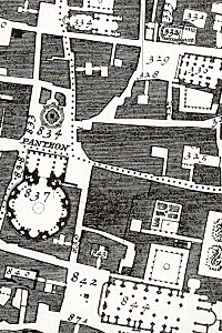
, the ''Pianta Grande di Roma'' which he began surveying in 1736 and engraved in 1748, and now universally known as the Nolli Map. The map is composed of 12 copper plate engravings that together measure by . It was produced and published in response to the commission of Pope Benedict XIV
Pope Benedict XIV ( la, Benedictus XIV; it, Benedetto XIV; 31 March 1675 – 3 May 1758), born Prospero Lorenzo Lambertini, was head of the Catholic Church and ruler of the Papal States from 17 August 1740 to his death in May 1758. Pope Be ...
to survey Rome in order to help create demarcations for the 14 traditional ''rioni'' or districts. It was by far the most accurate description of Rome produced to date at a time when the architectural achievement of the Papacy was in full flower.
Biography
Born in 1701 in Castiglione d'Intelvi (Como
Como (, ; lmo, Còmm, label= Comasco , or ; lat, Novum Comum; rm, Com; french: Côme) is a city and ''comune'' in Lombardy, Italy. It is the administrative capital of the Province of Como.
Its proximity to Lake Como and to the Alps h ...
), he moved to Rome
, established_title = Founded
, established_date = 753 BC
, founder = King Romulus (legendary)
, image_map = Map of comune of Rome (metropolitan city of Capital Rome, region Lazio, Italy).svg
, map_caption ...
thanks to the patronage of members of the patrician Albani and Corsini families.
As an architect, he worked on the churches of Sant'Alessio on the Aventine Hill (1743) and Santa Dorotea in Trastevere (1751–1756).
Nolli Map
The Nolli map reflects Bufalini's map of 1551, with which Nolli readily invited comparison, however Nolli made a number of important innovations. Firstly, Nolli reorients the city from east (which was conventional at the time) to magnetic north, reflecting Nolli's reliance on the compass to get a bearing on the city's topography. Secondly, though he follows Bufalini in using a figure-ground representation of built space with blocks and buildings shaded in a dark poché, Nolli represents enclosed public spaces such as the colonnades in St. Peter's Square and thePantheon
Pantheon may refer to:
* Pantheon (religion), a set of gods belonging to a particular religion or tradition, and a temple or sacred building
Arts and entertainment Comics
*Pantheon (Marvel Comics), a fictional organization
* ''Pantheon'' (Lone S ...
as open civic spaces. Finally, the map was a significant improvement in accuracy, even noting the asymmetry of the Spanish Steps
The Spanish Steps ( it, Scalinata di Trinità dei Monti) in Rome, Italy, climb a steep slope between the Piazza di Spagna at the base and Piazza Trinità dei Monti, dominated by the Trinità dei Monti church, at the top.
The monumental stairwa ...
. The map was used in government planning for the city of Rome until the 1970s; it was used as a base map for all Roman mapping and planning up to that date.
The map is framed with a ''vedute'' by Stefano Pozzi. A scaled-down edition, a collaboration between Nolli and Giovanni Battista Piranesi
Giovanni Battista (or Giambattista) Piranesi (; also known as simply Piranesi; 4 October 1720 – 9 November 1778) was an Italian Classical archaeologist, architect, and artist, famous for his etchings of Rome and of fictitious and atmospheric ...
, was published in the same year the original map was finished. Piranesi was instrumental in getting the work printed; Giuseppe Vasi also contributed.
See also
*Turgot map of Paris
The Turgot map of Paris (french: link=no, Plan de Turgot) is a highly accurate and detailed map of the city of Paris, France, as it existed in the 1730s. The map was commissioned by Parisian municipality chief Michel-Étienne Turgot, drawn up b ...
Notes
References
There have been a number of facsimile editions of the Nolli Map, two are listed here:'The New Plan of Rome'
By James Tice and Erik Steiner, University of Oregon Press, USA, 2006.
'The Nolli Plan of Rome: Facsimile'
Full-size facsimile portfolio of the original 19 sheets 56 cm x 81 cm 2"x 32"with 12pp intro. by Allen Ceen; J. H. Aronson Publisher, Highmount, NY 12441, 1st Ed. 1984, 2nd Ed. 1991.
External links
The interactive Nolli Map
b
B-Open Solutions
Roma Leggendaria
Nolli - Navigate Rome in 1748
the Nolli Map for iOS
a website dedicated to the Nolli map
{{DEFAULTSORT:Nolli, Giambattista 1701 births 1756 deaths 18th-century Italian architects Cartography by city People from Como