Geography of Liechtenstein on:
[Wikipedia]
[Google]
[Amazon]


 The principality of


 The principality of
 Liechtenstein
Liechtenstein (), officially the Principality of Liechtenstein (german: link=no, Fürstentum Liechtenstein), is a German-speaking microstate located in the Alps between Austria and Switzerland. Liechtenstein is a semi-constitutional monarchy ...
encompasses most of the eastern half of the Rhine
), Surselva, Graubünden, Switzerland
, source1_coordinates=
, source1_elevation =
, source2 = Rein Posteriur/Hinterrhein
, source2_location = Paradies Glacier, Graubünden, Switzerland
, source2_coordinates=
, so ...
Valley, wedged between Austria
Austria, , bar, Östareich officially the Republic of Austria, is a country in the southern part of Central Europe, lying in the Eastern Alps. It is a federation of nine states, one of which is the capital, Vienna, the most populous ...
and Switzerland
). Swiss law does not designate a ''capital'' as such, but the federal parliament and government are installed in Bern, while other federal institutions, such as the federal courts, are in other cities (Bellinzona, Lausanne, Luzern, Neuchâtel ...
. The majority of the country's population is found in the western half along the Rhine River. Along with Uzbekistan
Uzbekistan (, ; uz, Ozbekiston, italic=yes / , ; russian: Узбекистан), officially the Republic of Uzbekistan ( uz, Ozbekiston Respublikasi, italic=yes / ; russian: Республика Узбекистан), is a doubly landlocked cou ...
, Liechtenstein is one of only two doubly landlocked countries in the world.
Statistics
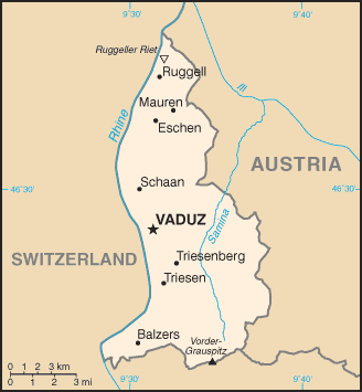
Geographic coordinates: Area: 160 km2 (land, 0 km2 water) Land boundaries :''total:'' 76 km :''border countries:'' Austria 35 km, Switzerland 41 km Lake :The only lake in Liechtenstein is theGampriner Seele
Gampriner Seele is the only lake in Liechtenstein. It was created by a flood of the Rhine River with enormous erosion in 1927. The lake lies at 435 metres above Sea Level in the village of Bendern–Gamprin.
Gampriner Seele is surrounded by a de ...
.
Land use
:''arable land:'' 21.88%
:''permanent crops:'' 0%
:''other:'' 78.12% (2011)
Terrain
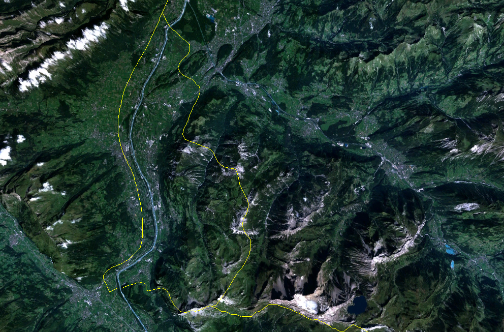
:Mostly mountainous (Alps) with Rhine Valley in western third
Natural resources:
:Hydroelectric
Hydroelectricity, or hydroelectric power, is electricity generated from hydropower (water power). Hydropower supplies one sixth of the world's electricity, almost 4500 TWh in 2020, which is more than all other renewable sources combined and ...
potential, arable land
Extreme points:
* North - river Rhine
), Surselva, Graubünden, Switzerland
, source1_coordinates=
, source1_elevation =
, source2 = Rein Posteriur/Hinterrhein
, source2_location = Paradies Glacier, Graubünden, Switzerland
, source2_coordinates=
, so ...
, Ruggell
Ruggell is a municipality of Liechtenstein. It is the northernmost and lowest elevated municipality. As of 2019, it has a population of 2,322.
History
The name is said to be from the Latin for "clearing the land" (roncale - ad roncalem). Most know ...
* South - summit of Mazorakopf/Falknishorn (2,452 m), Triesen
Triesen () is the third largest of Liechtenstein's municipalities. It contains several historic churches dating from the fifteenth century. It also has a weaving mill from 1863 that is considered a historical monument. The population is around 5, ...
* East - border post 28, above Nenzinger Himmel
Nenzinger Himmel (''"heaven of Nenzing"'') is the local name given to a collection of seasonal high-alpine settlements in the Gamperdonatal valley near the market town of Nenzing in the Austrian state of Vorarlberg. These include four alpine shie ...
* West - river Rhine, Balzers
Balzers is a village located in southern Liechtenstein. As of 2019, the village had a total population of 4,642. The main part of the village is situated along the east bank of the Rhine.
History and culture
Historically, the present-day form of ...
* highest - Vorder Grauspitz (2,599 m), Triesen
Triesen () is the third largest of Liechtenstein's municipalities. It contains several historic churches dating from the fifteenth century. It also has a weaving mill from 1863 that is considered a historical monument. The population is around 5, ...
* lowest - Bangserfeld (429 m), Ruggell
Ruggell is a municipality of Liechtenstein. It is the northernmost and lowest elevated municipality. As of 2019, it has a population of 2,322.
History
The name is said to be from the Latin for "clearing the land" (roncale - ad roncalem). Most know ...
Climate
Continental; cold, cloudy winters with frequent snow or rain; cool to moderately warm, cloudy, humid summers, great variety ofmicroclimates
A microclimate (or micro-climate) is a local set of atmospheric conditions that differ from those in the surrounding areas, often with a slight difference but sometimes with a substantial one. The term may refer to areas as small as a few squa ...
based on elevation.
Environment - international agreements
''Party to:''Air Pollution
Air pollution is the contamination of air due to the presence of substances in the atmosphere that are harmful to the health of humans and other living beings, or cause damage to the climate or to materials. There are many different types ...
,
Air Pollution-Persistent Organic Pollutants,
Air Pollution-Nitrogen Oxides,
Air Pollution-Sulphur 85, Air Pollution-Sulphur 94,
Air Pollution-Volatile Organic Compounds,
Biodiversity
Biodiversity or biological diversity is the variety and variability of life on Earth. Biodiversity is a measure of variation at the genetic (''genetic variability''), species (''species diversity''), and ecosystem (''ecosystem diversity'') l ...
,
Climate Change,
Climate Change-Kyoto Protocol
The Kyoto Protocol was an international treaty which extended the 1992 United Nations Framework Convention on Climate Change (UNFCCC) that commits state parties to reduce greenhouse gas emissions, based on the scientific consensus that (part ...
,
Desertification
Desertification is a type of land degradation in drylands in which biological productivity is lost due to natural processes or induced by human activities whereby fertile areas become increasingly arid. It is the spread of arid areas caused by ...
,
Endangered Species
An endangered species is a species that is very likely to become extinct in the near future, either worldwide or in a particular political jurisdiction. Endangered species may be at risk due to factors such as habitat loss, poaching and inv ...
,
Hazardous Wastes,
Ozone Layer Protection
The Montreal Protocol is an international treaty designed to protect the ozone layer by phasing out the production of numerous substances that are responsible for ozone depletion. It was agreed on 16 September 1987, and entered into force o ...
,
Wetlands
A wetland is a distinct ecosystem that is flooded or saturated by water, either permanently (for years or decades) or seasonally (for weeks or months). Flooding results in oxygen-free (anoxic) processes prevailing, especially in the soils. The ...
,
''Signed, but not ratified:''
Law of the Sea
References
Lists of coordinates