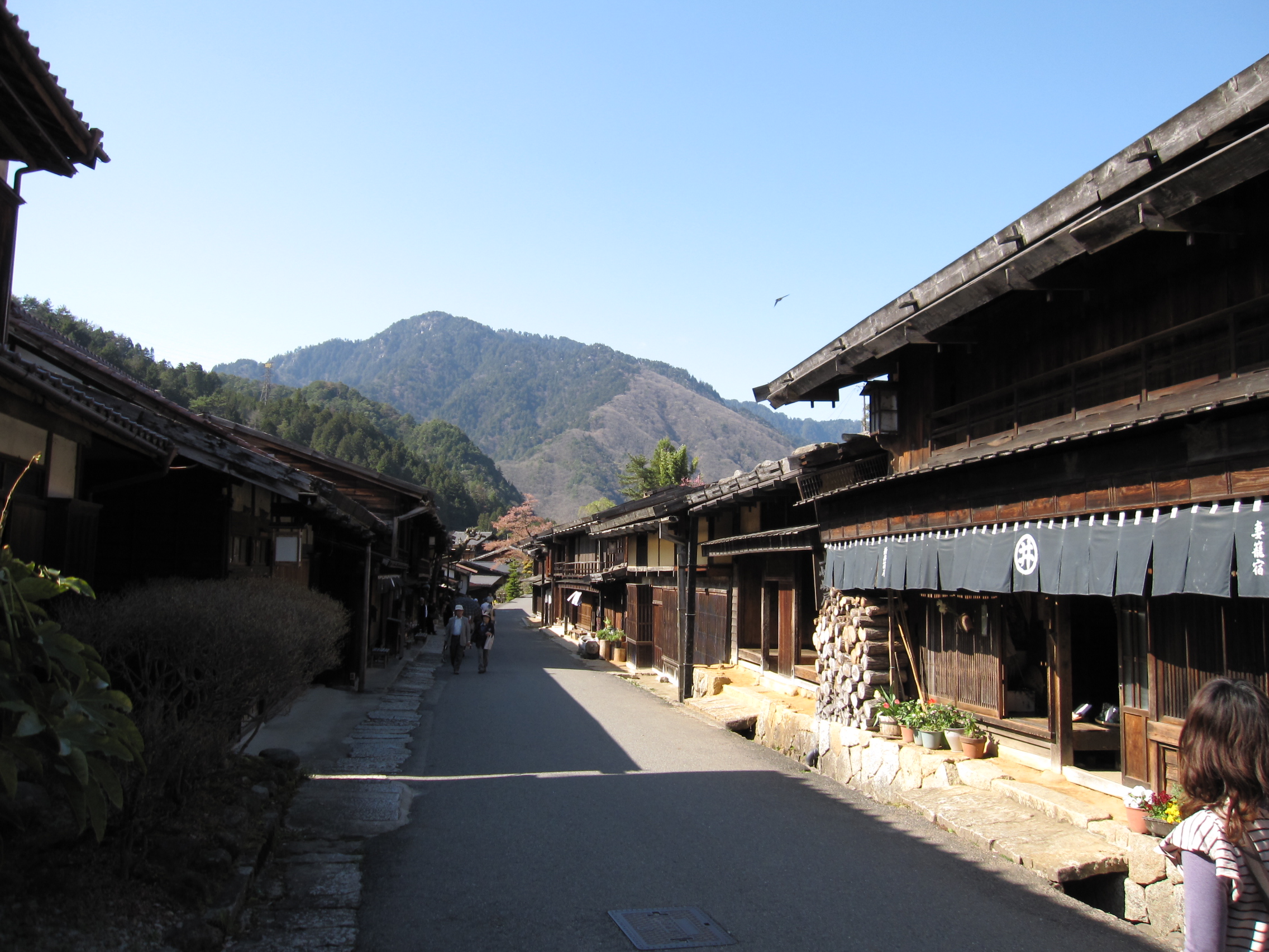
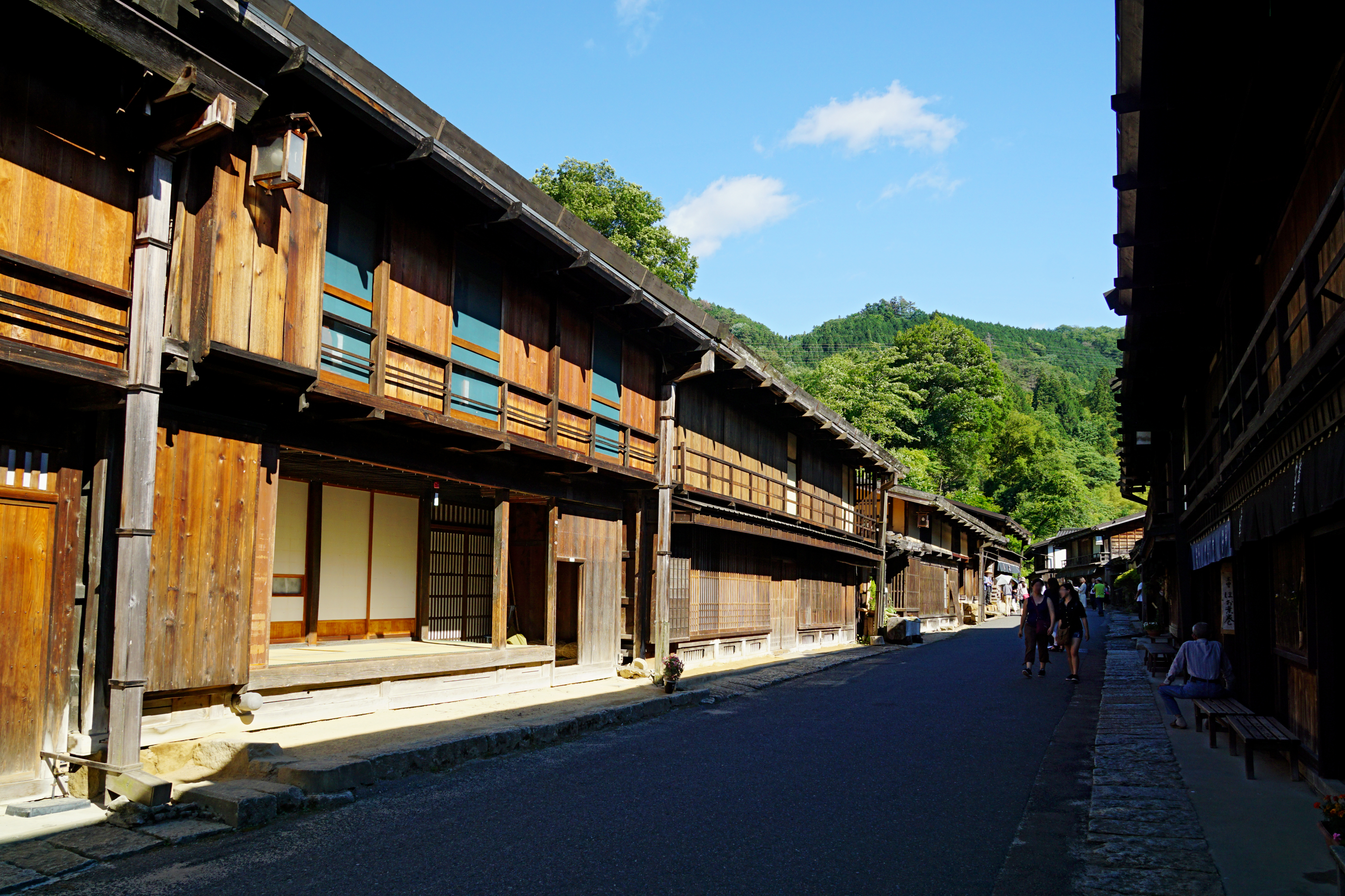
Tsumago 2009 5.JPG on:
[Wikipedia]
[Google]
[Amazon]


 was the forty-second of the sixty-nine post towns on the Nakasendō. It is located in
. Nagiso Town. Accessed November 29, 2007. *The Nagiso Museum of History (歴史資料館) contains information on the areas history, the preservation of row houses and data about row houses throughout the country. *Kabuto Kannon Shrine (かぶと観音) is a small shrine dedicated to Minamoto no Yoshinaka, the "General of the Rising Sun," who built a citadel at Tsumago. The shrine was built around 1180. *Tsumago Castle (妻籠城) is nothing but a few ruins today. During the Edo period, however, its mountaintop location gave it wonderful views of both Tsumago-juku and Midono-juku. It served as the site of a large battle in 1584 and was dismantled in the early 17th century, as a result of the Genna era's "one country, one castle" rule. *Rurisan Kōtoku-ji Temple (光徳寺), with its white walls and stone base, rises one story above the area's buildings. Founded in 1500, its main deity was added in 1599, and is notable for its
. Tsumago Sightseeing Association. Accessed July 10, 2007.
File:Tsumago 2009 17.JPG, Resting station for higher guests such as daimyō
File:150606 Tsumago-juku Nagiso Nagano pref Japan18n.jpg, Okuya, the ''waki-honjin''
File:150606 Tsumago-juku Nagiso Nagano pref Japan24n.jpg, The Nagiso Museum of History
File:Tsumago 2009 15.JPG, Old school building
File:Tsumago 2009 18.JPG, Rurisan Kōtoku-ji Temple
Map of Tsumago (Japanese)
Aerial view (Google Maps)
{{DEFAULTSORT:Tsumago-Juku Stations of the Nakasendō Stations of the Nakasendo in Nagano Prefecture

 was the forty-second of the sixty-nine post towns on the Nakasendō. It is located in
 Nagiso
is a town located in Nagano Prefecture, Japan. , the town had an estimated population of 4,111 in 1751 households, and a population density of 19 persons per km². The total area of the town was . Nagiso is listed as one of The Most Beautiful ...
, Kiso District, Nagano Prefecture
is a landlocked prefecture of Japan located in the Chūbu region of Honshū. Nagano Prefecture has a population of 2,052,493 () and has a geographic area of . Nagano Prefecture borders Niigata Prefecture to the north, Gunma Prefecture to the ...
, Japan
Japan ( ja, 日本, or , and formally , ''Nihonkoku'') is an island country in East Asia. It is situated in the northwest Pacific Ocean, and is bordered on the west by the Sea of Japan, while extending from the Sea of Okhotsk in the north ...
. It has been restored to its appearance as an Edo
Edo ( ja, , , "bay-entrance" or "estuary"), also romanized as Jedo, Yedo or Yeddo, is the former name of Tokyo.
Edo, formerly a ''jōkamachi'' (castle town) centered on Edo Castle located in Musashi Province, became the ''de facto'' capital of ...
-era post town and is now a popular tourist destination.
History
During the Edo period, Tsumago was the forty-second of the sixty-nine post towns, which connectedEdo
Edo ( ja, , , "bay-entrance" or "estuary"), also romanized as Jedo, Yedo or Yeddo, is the former name of Tokyo.
Edo, formerly a ''jōkamachi'' (castle town) centered on Edo Castle located in Musashi Province, became the ''de facto'' capital of ...
(present-day Tokyo) with Kyoto. Prior to becoming part of the Nakasendō, it was the tenth of eleven stations
Station may refer to:
Agriculture
* Station (Australian agriculture), a large Australian landholding used for livestock production
* Station (New Zealand agriculture), a large New Zealand farm used for grazing by sheep and cattle
** Cattle statio ...
along the Kisoji, a minor trade route running through the Kiso Valley
The is a geographical area that centers on the valley of the upper portions of the Kiso River in the southwestern part of Nagano Prefecture in Japan. It is a v-shaped valley with length of approximately 60 km (36 mi) that follows the r ...
. As such, it was a relatively prosperous and cosmopolitan town, with an economy based on currency.
In 1968, local residents began an effort to restore historical sites and structures within the town. By 1971, some 20 houses had been restored, and a charter was agreed to the effect that no place in Tsumago should be "sold, hired out, or destroyed". In 1976, the town was designated by the Japanese government as a Nationally Designated Architectural Preservation Site. Despite its historical appearance, however, Tsumago is fully inhabited, though with tourist shops as the town's main business.
Points of interest
Tsumago contains a number of interesting properties, including: *Tsumago-juku's former ''honjin
The ''honjin'' at Inaba Kaidō's Ōhara-shuku.">Ōhara-shuku.html" ;"title="Inaba Kaidō's Ōhara-shuku">Inaba Kaidō's Ōhara-shuku.
is the Japanese word for an inn for government officials, generally located in post stations (''shukuba'') dur ...
'' and Okuya, the ''waki-honjin'', are both open to visitors today. The ''honjin'', which was the main inn of the post town, was originally destroyed, but it was rebuilt in 1995. The original building of the ''waki-honjin'', which was the secondary inn, however, still remains and was named an Important Cultural Property in 2001.Tsumago-juku Honjin. Nagiso Town. Accessed November 29, 2007. *The Nagiso Museum of History (歴史資料館) contains information on the areas history, the preservation of row houses and data about row houses throughout the country. *Kabuto Kannon Shrine (かぶと観音) is a small shrine dedicated to Minamoto no Yoshinaka, the "General of the Rising Sun," who built a citadel at Tsumago. The shrine was built around 1180. *Tsumago Castle (妻籠城) is nothing but a few ruins today. During the Edo period, however, its mountaintop location gave it wonderful views of both Tsumago-juku and Midono-juku. It served as the site of a large battle in 1584 and was dismantled in the early 17th century, as a result of the Genna era's "one country, one castle" rule. *Rurisan Kōtoku-ji Temple (光徳寺), with its white walls and stone base, rises one story above the area's buildings. Founded in 1500, its main deity was added in 1599, and is notable for its
Nightingale floor
' are floors that make a chirping sound when walked upon. These floors were used in the hallways of some temples and palaces, the most famous example being Nijō Castle, in Kyoto, Japan. Dry boards naturally creak under pressure, but these fl ...
s and a 500-year-old weeping cherry tree out front.
Perhaps its most interesting aspect, however, is the restored row of houses along the former post road. Most were houses built for common people in the mid-18th century, with shops and inns for travelers along the Nakasendō.
A quiet portion of the original highway has been preserved between Tsumago and Magome
was the forty-third of the sixty-nine stations of the Nakasendō connecting Edo with Kyoto in Edo period Japan. It is located in former Mino Province in what is now part of the city of Nakatsugawa, Gifu Prefecture, Japan. It was also the last ...
, the next post town (also restored). It provides for a pleasant walk through the forests and past a waterfall. Also, so guests do not have to walk the path twice to return to the beginning of the hike, bus service is provided between the two ends of the road.Tsumago-juku. Tsumago Sightseeing Association. Accessed July 10, 2007.
Neighboring post towns
;Nakasendō & Kisoji : Midono-juku - Tsumago-juku -Magome-juku
was the forty-third of the sixty-nine stations of the Nakasendō connecting Edo with Kyoto in Edo period Japan. It is located in former Mino Province in what is now part of the city of Nakatsugawa, Gifu Prefecture, Japan. It was also the last ...
Access
Tsumago sits at the south end of the Kiso District at the juncture of Routes 19 and 256. It can also be reached via a nearby railway station at the town ofNagiso
is a town located in Nagano Prefecture, Japan. , the town had an estimated population of 4,111 in 1751 households, and a population density of 19 persons per km². The total area of the town was . Nagiso is listed as one of The Most Beautiful ...
on the Chūō Main Line
The , commonly called the Chūō Line, is one of the major trunk railway lines in Japan. It connects Tokyo and Nagoya, although it is the slowest direct railway connection between the two cities; the coastal Tōkaidō Main Line is slightly faste ...
.
See also
*Groups of Traditional Buildings is a Japanese category of historic preservation introduced by a 1975 amendment of the law which mandates the protection of groups of traditional buildings which, together with their environment, form a beautiful scene. They can be post towns, castl ...
References
External links
Map of Tsumago (Japanese)
Aerial view (Google Maps)
{{DEFAULTSORT:Tsumago-Juku Stations of the Nakasendō Stations of the Nakasendo in Nagano Prefecture