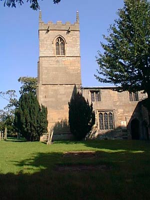
Egmanton church.jpg on:
[Wikipedia]
[Google]
[Amazon]
Egmanton is a small village and
The amenities include an Anglican church, a village hall (formerly the old school) and a pub, 'The Old Plough'. The main economic activity in the village is farming.
 Church of Our Lady of Egmanton, Egmanton church is best known for the Shrine of Our Lady of Egmanton contained within the church itself. A pilgrimage takes place to commemorate the shrine
More information on Egmanton Churc
The official website for the villageThe Egmanton Village Hall websiteMap of Egmanton
courtesy of multimap.com.
More information on the Caunton Ward from the UK Office for National Statistics
{{authority control Shrines to the Virgin Mary Newark and Sherwood Villages in Nottinghamshire
civil parish
In England, a civil parish is a type of administrative parish used for local government. It is a territorial designation which is the lowest tier of local government below districts and counties, or their combined form, the unitary authorit ...
in Nottinghamshire
Nottinghamshire (; abbreviated Notts.) is a landlocked county in the East Midlands region of England, bordering South Yorkshire to the north-west, Lincolnshire to the east, Leicestershire to the south, and Derbyshire to the west. The trad ...
, England, and is located one mile south of Tuxford
Tuxford is a historic market town and a civil parish in the Bassetlaw district of Nottinghamshire, England. At the 2001 census, it had a population of 2,516, increasing to 2,649 at the 2011 census.
Geography
Nearby towns are Ollerton, Ret ...
and one mile north of Laxton. The population of the civil parish taken at the 2011 Census was 286. The name derives from the Old English
Old English (, ), or Anglo-Saxon, is the earliest recorded form of the English language, spoken in England and southern and eastern Scotland in the early Middle Ages. It was brought to Great Britain by Anglo-Saxon settlers in the mid-5th c ...
words for Ecgmund's farm/settlement.
The nearest larger towns are Retford
Retford (), also known as East Retford, is a market town in the Bassetlaw District in Nottinghamshire, England, and one of the oldest English market towns having been granted its first charter in 1105. It lies on the River Idle and the Chesterf ...
and Newark-on-Trent
Newark-on-Trent or Newark () is a market town and civil parish in the Newark and Sherwood district in Nottinghamshire, England. It is on the River Trent, and was historically a major inland port. The A1 road (Great Britain), A1 road bypasses th ...
. It is located approximately 35 metres above sea level.
It is part of the Caunton Ward of the administrative district of Newark and Sherwood
Newark and Sherwood is a local government district and is the largest district in Nottinghamshire, England. The district was formed on 1 April 1974, by a merger of the municipal borough of Newark with Newark Rural District and Southwell R ...
District Council and the county of Nottinghamshire. It lies within the Parliamentary constituency of Newark
Newark most commonly refers to:
* Newark, New Jersey, city in the United States
* Newark Liberty International Airport, New Jersey; a major air hub in the New York metropolitan area
Newark may also refer to:
Places Canada
* Niagara-on-the ...
.
Egmanton was mentioned in the Domesday Survey
Domesday Book () – the Middle English spelling of "Doomsday Book" – is a manuscript record of the "Great Survey" of much of England and parts of Wales completed in 1086 by order of King William I, known as William the Conqueror. The manusc ...
of 1086.
According to the 2001 census it has 254 inhabitants in 101 householdThe amenities include an Anglican church, a village hall (formerly the old school) and a pub, 'The Old Plough'. The main economic activity in the village is farming.
Historical sites
Egmanton Church – 'Our Lady of Egmanton Church'
 Church of Our Lady of Egmanton, Egmanton church is best known for the Shrine of Our Lady of Egmanton contained within the church itself. A pilgrimage takes place to commemorate the shrine
More information on Egmanton Churc
Egmanton Castle
Egmanton Castle consists of the remains of a Motte and Bailey style castle. It is commonly known as Gaddick Hill.Medieval fish ponds
To the west of the village off Kirton road are some earthworks which are the remains of medieval fish ponds, now dry. The following links provide more information on the importance of fish ponds to people in the Middle AgesWindmill
A towerwindmill
A windmill is a structure that converts wind power into rotational energy using vanes called sails or blades, specifically to mill grain (gristmills), but the term is also extended to windpumps, wind turbines, and other applications, in some ...
was located at the southern end of Mill Lane ().
Oil fields
Oil has been produced from the East Midlands oil fields since 1939 with some production wells located around Egmanton. Although many have now closed, some of these wells remain in production to this day. On a national scale the level of production was never significantSee also
* Listed buildings in EgmantonReferences
External links
The official website for the village
courtesy of multimap.com.
{{authority control Shrines to the Virgin Mary Newark and Sherwood Villages in Nottinghamshire