Fangmatan on:
[Wikipedia]
[Google]
[Amazon]
Fangmatan () is an
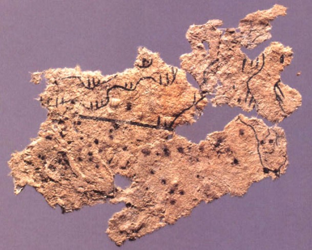
 Tomb 5, which was also excavated in 1986, dates to the early Western Han (early 2nd century BCE). The occupant of the tomb was buried with a paper map laid on his chest, but due to water damage only a single fragment (5.6 × 2.6 cm) of the map has survived. The map, which depicts topographic features such as mountains, waterways and roads, is drawn on the oldest extant piece of paper.
archeological
Archaeology or archeology is the scientific study of human activity through the recovery and analysis of material culture. The archaeological record consists of artifacts, architecture, biofacts or ecofacts, sites, and cultural landsca ...
site located near Tianshui
Tianshui is the second-largest city in Gansu Province, China. The city is located in the southeast of the province, along the upper reaches of the Wei River and at the boundary of the Loess Plateau and the Qinling Mountains. As of the 2020 ce ...
in China
China, officially the People's Republic of China (PRC), is a country in East Asia. It is the world's List of countries and dependencies by population, most populous country, with a Population of China, population exceeding 1.4 billion, slig ...
's Gansu
Gansu (, ; alternately romanized as Kansu) is a province in Northwest China. Its capital and largest city is Lanzhou, in the southeast part of the province.
The seventh-largest administrative district by area at , Gansu lies between the Tibe ...
province. The site was located within the Qin state
Qin () was an ancient Chinese state during the Zhou dynasty. Traditionally dated to 897 BC, it took its origin in a reconquest of western lands previously lost to the Rong; its position at the western edge of Chinese civilization permitted ex ...
, and includes several burials dating from the Warring States
The Warring States period () was an era in ancient Chinese history characterized by warfare, as well as bureaucratic and military reforms and consolidation. It followed the Spring and Autumn period and concluded with the Qin wars of conquest ...
period through to the early Western Han
The Han dynasty (, ; ) was an imperial dynasty of China (202 BC – 9 AD, 25–220 AD), established by Liu Bang (Emperor Gao) and ruled by the House of Liu. The dynasty was preceded by the short-lived Qin dynasty (221–207 BC) and a war ...
.
Tomb 1
The date of the burial of Tomb 1 was approximately 230 to 220 BCE at the very end of theWarring States
The Warring States period () was an era in ancient Chinese history characterized by warfare, as well as bureaucratic and military reforms and consolidation. It followed the Spring and Autumn period and concluded with the Qin wars of conquest ...
period; it was excavated in 1986. The tomb contained a number of long-lost texts written on bamboo slips
Bamboo and wooden slips () were the main media for writing documents in China before the widespread introduction of paper during the first two centuries AD. (Silk was occasionally used, for example in the Chu Silk Manuscript, but was prohibiti ...
, including almanac
An almanac (also spelled ''almanack'' and ''almanach'') is an annual publication listing a set of current information about one or multiple subjects. It includes information like weather forecasts, farmers' planting dates, tide tables, and othe ...
s (Rishu
Rishu ('')'', lit. "Day Book," is a genre of divinatory texts that circulated widely in China from the late Warring States Period to the Western Han dynasty. Rishu is also the name of one of the primary literatures for the schools of orthodox Sh ...
日書), legal texts, medical works, and seven maps. The maps are drawn in black ink on four rectangular pieces of pine wood, 26.7 cm in length and between 15 and 18.1 cm in width, and depict the tributary river systems of the Jialing River
The Jialing River, formerly known by numerous other names, is a major tributary of the Yangtze River in the Sichuan Basin. It is named after the Jialing Valley in Feng County, Shaanxi through which it flows.
The Jialing River's most notable ...
in modern Sichuan
Sichuan (; zh, c=, labels=no, ; zh, p=Sìchuān; alternatively romanized as Szechuan or Szechwan; formerly also referred to as "West China" or "Western China" by Protestant missions) is a province in Southwest China occupying most of t ...
province. The areas covered by the seven maps overlap, but in total they cover 107 × 68 km in area.
Tomb 5
 Tomb 5, which was also excavated in 1986, dates to the early Western Han (early 2nd century BCE). The occupant of the tomb was buried with a paper map laid on his chest, but due to water damage only a single fragment (5.6 × 2.6 cm) of the map has survived. The map, which depicts topographic features such as mountains, waterways and roads, is drawn on the oldest extant piece of paper.
Notes
Bibliography
* *. *. * * {{Prehistoric cultures of China Archaeological sites in China