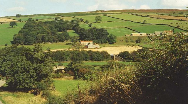
Eskdale, North Yorkshire on:
[Wikipedia]
[Google]
[Amazon]

 Eskdale is a valley running west to east from

 Eskdale is a valley running west to east from
 Westerdale
Westerdale is a village, civil parish and dale within the Scarborough district of North Yorkshire, England. The Esk Valley Walk runs through part of the village. The village is at the confluence of three streams (Esklets) which combine as th ...
on the North York Moors
The North York Moors is an upland area in north-eastern Yorkshire, England. It contains one of the largest expanses of Calluna, heather moorland in the United Kingdom. The area was designated as a national parks of England and Wales, National P ...
to Whitby
Whitby is a seaside town, port and civil parish in the Scarborough borough of North Yorkshire, England. Situated on the east coast of Yorkshire at the mouth of the River Esk, Whitby has a maritime, mineral and tourist heritage. Its East Clif ...
on the Yorkshire Coast
The Yorkshire Coast runs from the Tees estuary to the Humber estuary, on the east coast of England. The cliffs at Boulby are the highest on the east coast of England, rising to above the sea level.
The North York Moors National Park extends u ...
of England
England is a country that is part of the United Kingdom. It shares land borders with Wales to its west and Scotland to its north. The Irish Sea lies northwest and the Celtic Sea to the southwest. It is separated from continental Europe b ...
.
Formed during the last major ice age, it has a classic U-shaped valley
U-shaped valleys, also called trough valleys or glacial troughs, are formed by the process of glaciation. They are characteristic of mountain glaciation in particular. They have a characteristic U shape in cross-section, with steep, straight s ...
formation caused by the action of glaciers carving away the rock.
Eskdale is named after its river which in Celtic means water or stream. The dale carries the River Esk from the "Esklets" above Westerdale to the sea at Whitby. The tops of its steep-sided valleys are noted for their heather moorland, whilst below the land is mainly split between pasture for cows and Swaledale sheep
Swaledale is a breed of domestic sheep named after the Yorkshire valley of Swaledale in England. They are found throughout the more mountainous areas of Great Britain, but particularly in the Yorkshire Dales, County Durham, and around the penni ...
and arable crops such as Oil seed rape
Rapeseed (''Brassica napus ''subsp.'' napus''), also known as rape, or oilseed rape, is a bright-yellow flowering member of the family Brassicaceae (mustard or cabbage family), cultivated mainly for its oil-rich seed, which naturally contains a ...
.
The Esk Valley Walk
The Esk Valley Walk is a long distance footpath in North Yorkshire, England. The route first follows a loop on the North York Moors to the south of Castleton, then shadows the River Esk on its journey to the North Sea. Waymarking uses the ...
is a walk covering starting from the head of the Esk through the valley and down to Whitby. Eskdale School
Eskdale School is a coeducational secondary school located in Whitby, North Yorkshire, England. The school is named after Eskdale, a valley that runs from Whitby to Westerdale.
It is a community school administered by North Yorkshire County ...
in Whitby is named after the valley.
The Esk Valley Line runs through Eskdale from Commondale
Commondale is a village and civil parish in the Scarborough
district of North Yorkshire, England that lies within the North York Moors National Park.
The village is served by Commondale railway station. It has a small pub called The Clevelan ...
eastwards towards Whitby and is named after the dale.
The river flows through the narrow valley that the water has cut into the soft shale of the Jurassic rocks. Because of this, the rainfall can cause rapid flooding like those suffered in 1840, 1930 and in 2000. The 1930 flood caused many problems including destroying the bridge over the river in Sleights
Sleights is a village in North Yorkshire, England. Located in the Esk Valley in the postal region of Whitby, the village is part of the civil parish of Eskdaleside cum Ugglebarnby and the borough of Scarborough (borough), Scarborough. Sleights l ...
. The A169
The A169 is an A road in North Yorkshire, England. It runs from the A64 at Malton on the edge of the Yorkshire Wolds through the Vale of Pickering and across the North York Moors to join the A171 just west of Whitby. It is a single carriage ...
road bridge that runs over the Esk in Sleights village dates from 1937.
A natural gas accumulation is present in the Permian dolomitic limestones at Eskdale. Natural gas from this field was used in the 1960s and 1970s by the former North Eastern Gas Board to supply Whitby and other local towns.
References
Valleys of the North York Moors {{Scarborough-geo-stub